|
Author
Reichspostamt
Full Title
Karte der grossen Postdampfschifflinien im Weltpostverkehr. [Map of the major postal steamship lines in world postal traffic.]
List No
15829.001
Author
Reichspostamt
Full Title
(Covers to) Karte der grossen Postdampfschifflinien im Weltpostverkehr. [Map of the major postal steamship lines in world postal traffic.]
List No
15829.002
Author
Reichspostamt
Full Title
(Text page to) Karte der grossen Postdampfschifflinien im Weltpostverkehr. [Map of the major postal steamship lines in world postal traffic.]
List No
15829.003
Note
Identified the numbered routes on the world map and gives distances from ports to ports.
Author
Millroy & Hayes
Full Title
Route of the Mormon pioneers from Nauvoo to Great Salt Lake. Feb'y 1846-July 1847. Copyright 1899, by Millroy & Hayes.
List No
11143.000
Note
Colored panoramic pictorial map of the region between the Mississippi River and the Great Salt Lake, illustrating the overland trek of the Mormons in 1846 and 1847, which is drawn from Orson' Pratt's record of the trip. Depicting the Mormon settlers' route west from Illinois to Utah, 1846-1847, seeking to escape harassment. The Mormons left their embattled settlement in Nauvoo, Illinois, in 1846, reaching their destination in the Valley of the Great Salt Lake a year later. This map charts the Saints progress across the midwest and plains with four vignettes showing a wagon train, a group of tepees, a buffalo herd, and numerous other scenes from the journey, and miles traveled daily. Each campsite along the route is noted with the dates which the emigrant party stayed at each site. A remarkable depiction of one of the great episodes in American history, produced to commemorate the 50th anniversary of the journey. Includes explanation.
Author
Millroy & Hayes
Full Title
(Covers to) Guide to the route map of the Mormon pioneers from Nauvoo to Great Salt Lake, 1846-1847. Millroy & Hayes, Map publishers. 233 State Street, Salt Lake City, Utah.
List No
11144.001
Note
31 pages guide to the route map of the Mormon pioneers, bound in beige paper covers, with the view of Brigham Young monument, introductory note: In presenting this guide to the "route map of the Mormon Pioneers" we desire to acknowledge the Kindness of Apostle Franklin D. Richards ..." and text. Date taken from the map. "Price 10 cents. Copies of the pictorial map, with guide book, packed in tubes, ready for mailing to any part of the world ..." See our 11143.000 for a copy of the Route map of the Mormon Pioneers.
Author
Millroy & Hayes
Full Title
(Title Page to) Guide to the route map of the Mormon pioneers from Nauvoo to Great Salt Lake, 1846-1847. Millroy & Hayes, Map publishers. 233 State Street, Salt Lake City, Utah.
List No
11144.002
Note
31 pages guide to the route map of the Mormon pioneers, bound in beige paper covers, with the view of Brigham Young monument, introductory note: In presenting this guide to the "route map of the Mormon Pioneers" we desire to acknowledge the Kindness of Apostle Franklin D. Richards ..." and text. Date taken from the map. "Price 10 cents. Copies of the pictorial map, with guide book, packed in tubes, ready for mailing to any part of the world ..." 31 pages guide to the route map of the Mormon pioneers, bound in beige paper covers, with the view of the Brigham Young monument, introductory note: See our 11143.000 for a copy of the Route map of the Mormon Pioneers.
Author
Millroy & Hayes
Full Title
(Text Page to) Guide to the route map of the Mormon pioneers from Nauvoo to Great Salt Lake, 1846-1847. Millroy & Hayes, Map publishers. 233 State Street, Salt Lake City, Utah.
List No
11144.003
Note
31 pages guide to the route map of the Mormon pioneers, bound in beige paper covers, with the view of the Brigham Young monument, introductory note: In presenting this guide to the "route map of the Mormon Pioneers" we desire to acknowledge the Kindness of Apostle Franklin D. Richards ..." and text. Date taken from the map. "Price 10 cents. Copies of the pictorial map, with guide book, packed in tubes, ready for mailing to any part of the world ..." See our 11143.000 for a copy of the Route map of the Mormon Pioneers.
Author
Millroy & Hayes
Full Title
(Composite text) Guide to the route map of the Mormon pioneers from Nauvoo to Great Salt Lake, 1846-1847. Millroy & Hayes, Map publishers. 233 State Street, Salt Lake City, Utah.
List No
11144.004
Note
31 pages guide to the route map of the Mormon pioneers, bound in beige paper covers, with the view of the Brigham Young monument, introductory note: In presenting this guide to the "route map of the Mormon Pioneers" we desire to acknowledge the Kindness of Apostle Franklin D. Richards ..." and text. Date taken from the map. "Price 10 cents. Copies of the pictorial map, with guide book, packed in tubes, ready for mailing to any part of the world ..." See our 11143.000 for a copy of the Route map of the Mormon Pioneers.
Author
Cram, George Franklin, 1841-1928
Full Title
(Title Page to) Cram's standard American railway system atlas of the world. Accompanied with a complete and simple index of the United States showing the true location of all railroads, towns, villages and post offices ... Maps of the United States are the largest scale and clearest print of any maps published. Foreign maps are compiled largely from charts of the Royal Geographical Society and are geographically correct. Published by Geo. F. Cram, 89 Fulton Street, New York; 61-63 Plymouth Place, Chicago, 1899.
List No
14372.002
Note
Title page to Cram's standard American railway system atlas. Includes extended description of maps, as well as imprint. (Page number inferred.)
Author
Cram, George Franklin, 1841-1928
Full Title
(Contents to) Table of contents.
List No
14372.003
Note
Table of contents to Cram's standard American railway system atlas. Lists place names - "Divisions" - with associated page numbers. With note. (Page number inferred.)
Author
Cram, George Franklin, 1841-1928
Full Title
(Composite Map to) New York : Western half. -- New York : Eastern half. 1899, by Geo. F. Cram.
List No
14372.022
Note
Composite map of New York (western and eastern halves). Shows political boundaries, counties, towns, railroads, steamship lines, topography, bodies of water, drainage, coastlines and islands. Relief shown with hachures. Includes keys with explanations, latitudinal and longitudinal lines, as well as bar scales given in miles. With alphanumeric grid corresponding to "Index of New York" on pages 27-29, 32-35, 38-41 and 44. Colored lithograph. Together, maps are 56 x 80 cm, on two double sheets 67 x 90 cm. "Index of maps" and "Index of cities" in margins, providing navigation for atlas as a whole.
Author
Cram, George Franklin, 1841-1928
Full Title
(Composite Map to) Western half of Pennsylvania. -- Eastern half of Pennsylvania. 1899, by Geo. F. Cram.
List No
14372.036
Note
Composite map of Pennsylvania (western and eastern halves). Shows political boundaries, counties, towns, railroads, steamship lines, topography, bodies of water, drainage, coastlines and islands. Relief shown with hachures. Includes keys with explanations, latitudinal and longitudinal lines, as well as bar scales given in miles. With alphanumeric grid corresponding to "Index of Pennsylvania" on pages 45-55, 58-61 and 64-67. Colored lithograph. Together, maps are 54 x 85 cm, on two double sheets 67 x 90 cm. "Index of maps" and "Index of cities" in margins, providing navigation for atlas as a whole.
Author
Cram, George Franklin, 1841-1928
Full Title
(Composite Map to) Western half of Virginia and West Virginia. -- Eastern half of Virginia and West Virginia. 1899, by Geo. F. Cram.
List No
14372.056
Note
Composite map of Virginia and West Virginia (western and eastern halves). Shows political boundaries, counties, towns, railroads, steamship lines, topography, bodies of water, drainage, coastlines and islands. Relief shown with hachures. Includes keys with explanations, latitudinal and longitudinal lines, as well as bar scales given in miles. With alphanumeric grid corresponding to "Index of Virginia" on pages 85-93 and 96-98, and "Index of West Virginia" on pages 99, 102-105 and 108-110. Colored lithograph. Together, maps are 55 x 85 cm, on two double sheets 67 x 90 cm. "Index of maps" and "Index of cities" in margins, providing navigation for atlas as a whole.
Author
Cram, George Franklin, 1841-1928
Full Title
(Composite Map to) Ohio : North half. -- Ohio : [South half]. 1899, by Geo. F. Cram.
List No
14372.067
Note
Composite map of Ohio (northern and southern halves). Shows political boundaries, counties, towns, railroads, steamship lines, topography, bodies of water, drainage, coastlines and islands. Relief shown with hachures. Includes keys with explanations, latitudinal and longitudinal lines, as well as bar scales given in miles. With alphanumeric grid corresponding to "Index of Ohio" on pages 111-113, 116-119, 122-125 and 128. Colored lithograph. Together, maps are 80 x 55 cm, on two double sheets 90 x 67 cm. "Index of maps" and "Index of cities" in margins, providing navigation for atlas as a whole.
Author
Cram, George Franklin, 1841-1928
Full Title
Michigan. 1899, by Geo. F. Cram.
List No
14372.076
Note
Map of Michigan. Shows political boundaries, counties, towns, railroads, steamship lines, topography, bodies of water, drainage, coastlines and islands. Relief shown with hachures. Includes key with explanation, latitudinal and longitudinal lines, as well as a bar scale given in miles. Two inset maps: Lake Superior -- L. Superior. With alphanumeric grid corresponding to "Index of Michigan" on pages 129-137 and 140. Colored lithograph. Map is 55 x 40 cm, on double sheet 67 x 45 cm. "Index of maps" and "Index of cities" in margins, providing navigation for atlas as a whole.
Author
Cram, George Franklin, 1841-1928
Full Title
Colorado. 1899, by Geo. F. Cram.
List No
14372.114
Note
Map of Colorado. Shows political boundaries, counties, towns, railroads, topography, bodies of water, drainage, coastlines and islands. Relief shown with hachures. Includes key with explanation, latitudinal and longitudinal lines, as well as a bar scale given in miles. With alphanumeric grid corresponding to "Index of Colorado" on pages 208-211 and 214-215. Colored lithograph. Map is 40 x 55 cm, on double sheet 45 x 67 cm. "Index of maps" and "Index of cities" in margins, providing navigation for atlas as a whole.
Author
Cram, George Franklin, 1841-1928
Full Title
Minnesota. 1899, by Geo. F. Cram.
List No
14372.124
Note
Map of Minnesota. Shows political boundaries, counties, towns, railroads, steamship lines, topography, bodies of water, drainage, coastlines and islands. Relief shown with hachures. Includes key with explanation, latitudinal and longitudinal lines, as well as a bar scale given in miles. Inset map: St. Paul and Minneapolis. With alphanumeric grid corresponding to "Index of Minnesota" on pages 226-231 and 234. Colored lithograph. Map, divided into two parts, is 55 x 40 cm, on double sheet 67 x 45 cm. "Index of maps" and "Index of cities" in margins, providing navigation for atlas as a whole.
Author
Cram, George Franklin, 1841-1928
Full Title
(Composite Map to) Western half of Texas. -- Eastern half of Texas. 1899, by Geo. F. Cram.
List No
14372.187
Note
Composite map of Texas (western and eastern halves). Shows political boundaries, counties, towns, railroads, steamship lines, topography, bodies of water, drainage, coastlines and islands. Relief shown with hachures. Includes keys with explanations, latitudinal and longitudinal lines, as well as bar scales given in miles. With alphanumeric grid corresponding to "Index of Texas" on pages 341, 344-347, 350-353 and 356. Colored lithograph. Together, map is 57 x 81 cm, on two double sheets 67 x 90 cm. "Index of maps" and "Index of cities" in margins, providing navigation for atlas as a whole.
Author
Cram, George Franklin, 1841-1928
Full Title
Oklahoma and Indianters. 1899, by Geo. F. Cram.
List No
14372.193
Note
Map of Oklahoma and Indiana. Shows political boundaries, counties, towns, railroads, topography, bodies of water, drainage, coastlines and islands. Relief shown with hachures. Includes key with explanation, latitudinal and longitudinal lines, as well as a bar scale given in miles. With alphanumeric grid corresponding to "Index of Indian Territory" on pages 357-358; "Index of Oklahoma Territory" on pages 359 and 362. Colored lithograph. Map, divided into two parts, is 40 x 57 cm, on double sheet 45 x 67 cm. "Index of maps" and "Index of cities" in margins, providing navigation for atlas as a whole.
Author
Cram, George Franklin, 1841-1928
Full Title
San Francisco.
List No
14372.198
Note
Map of San Francisco, California. Shows railroads, streets, parks, hills, bodies of water, drainage, coastlines and islands. Includes key with explanation. With alphanumeric grid corresponding to "Reference to figures" at top. Colored lithograph. Map is 28 x 28 cm, on sheet 45 x 33 cm.
Author
Cram, George Franklin, 1841-1928
Full Title
Nevada. 1899, by Geo. F. Cram.
List No
14372.200
Note
Map of Nevada. Shows political boundaries, counties, towns, railroads, topography, bodies of water, drainage, coastlines and islands. Relief shown with hachures. Includes key with explanation, latitudinal and longitudinal lines, as well as a bar scale given in miles. With alphanumeric grid corresponding to "Index of Nevada" on page 371. Colored lithograph. Map is 55 x 39 cm, on double sheet 67 x 45 cm. "Index of maps" and "Index of cities" in margins, providing navigation for atlas as a whole.
Author
Cram, George Franklin, 1841-1928
Full Title
(Composite Map to) California and Nevada : Northern half. -- California and Nevada : Southern half. 1899, by Geo. F. Cram.
List No
14372.205
Note
Composite map of California and Nevada (northern and southern halves). Shows political boundaries, counties, towns, railroads, topography, bodies of water, drainage, coastlines and islands. Relief shown with hachures. Includes keys with explanations, latitudinal and longitudinal lines, as well as bar scales given in miles. With alphanumeric grid corresponding to "Index of Nevada" on page 371; "Index of California" on pages 374-375, 378-379 and 382. Colored lithograph. Together, maps are 82 x 57 cm, on two double sheets 90 x 67 cm. "Index of maps" and "Index of cities" in margins, providing navigation for atlas as a whole.
Author
Cram, George Franklin, 1841-1928
Full Title
Montana. 1899, by Geo. F. Cram.
List No
14372.211
Note
Map of Montana. Shows political boundaries, counties, towns, railroads, topography, bodies of water, drainage, coastlines and islands. Relief shown with hachures. Includes key with explanation, latitudinal and longitudinal lines, as well as a bar scale given in miles. With alphanumeric grid corresponding to "Index of Montana" on pages 387 and 390. Colored lithograph. Map is 40 x 56 cm, on double sheet 45 x 67 cm. "Index of maps" and "Index of cities" in margins, providing navigation for atlas as a whole.
Author
Cram, George Franklin, 1841-1928
Full Title
(Index Page to) Index to state map of Wyoming. (2) -- Yellowstone National Park, Wyoming. 1899, by Geo. F. Cram.
List No
14372.216
Note
Index to the map of Wyoming on preceding pages, 396-397. Lists railroads, counties and towns (including population) in alphabetical order, with associated alphanumeric coordinate points from grid on map. Includes explanation. Index on pages 395 and 398. Also, map of Yellowstone National Park, Wyoming. Shows political boundaries, topography, plateaus, canyons, basins, bodies of water, hot springs, geysers, drainage, shorelines and islands. Relief shown with hachures. Includes latitudinal and longitudinal lines, as well as a bar scale given in miles. With alphanumeric grid corresponding to "Index of Wyoming" above map and preceding on page 395. Colored lithograph. Map is 26 x 23 cm, on sheet 45 x 33 cm.
Author
Cram, George Franklin, 1841-1928
Full Title
(Composite Map to) Western part of Washington. -- Eastern part of Washington. 1899, by Geo. F. Cram.
List No
14372.223
Note
Composite map of Washington (western and eastern halves). Shows political boundaries, counties, towns, Indian reservations, mines, railroads, topography, bodies of water, drainage, coastlines and islands. Relief shown with hachures. Includes keys with explanations, latitudinal and longitudinal lines, as well as bar scales given in miles. With alphanumeric grid corresponding to "Index of Washington" on pages 403 and 406-407. Colored lithograph. Together, map is 55 x 80 cm, on two double sheets 67 x 90 cm. "Index of maps" and "Index of cities" in margins, providing navigation for atlas as a whole.
Author
Cram, George Franklin, 1841-1928
Full Title
Boston.
List No
14372.227
Note
Map of Boston, Massachusetts. Shows political boundaries, railroads, streets, parks, bodies of water, drainage, shoreline and islands. Includes a bar scale given in miles and compass rose with north oriented toward upper left. Map indexed to indicate businesses, churches and theaters, etc. Colored lithograph. Map is 31 x 24 cm, on sheet 45 x 33 cm.
Author
Cram, George Franklin, 1841-1928
Full Title
Alaska. 1899, by Geo. F. Cram.
List No
14372.238
Note
Map of Alaska. Shows political boundaries, districts, towns, railroads, topography, glaciers, bodies of water, drainage, coastlines and islands. Relief shown with hachures. Includes key with explanation, latitudinal and longitudinal lines, as well as a bar scale given in miles. Three inset maps: Cook Inlet -- Yukon River -- Klondike District. With alphanumeric grid corresponding to "Index of Alaska" on page 427. Colored lithograph. Map is 40 x 56 cm, on double sheet 45 x 67 cm. "Index of maps" and "Index of cities" in margins, providing navigation for atlas as a whole.
Author
Cram, George Franklin, 1841-1928
Full Title
(Composite Map to) Western half of Nova Scotia. -- Eastern half of Nova Scotia. 1899, by Geo. F. Cram.
List No
14372.247
Note
Composite map of Nova Scotia, Canada (western and eastern halves). Shows political boundaries, counties, towns, railroads, topography, bodies of water, drainage, coastlines and islands. Relief shown with hachures. Includes keys with explanations, latitudinal and longitudinal lines, as well as bar scales given in miles. With alphanumeric grid corresponding to "Index of Nova Scotia" on pages 435 and 438-439. Colored lithograph. Together, map is 55 x 80 cm, on double sheet 67 x 90 cm. "Index of maps" and "Index of cities" in margins, providing navigation for atlas as a whole.
Author
Cram, George Franklin, 1841-1928
Full Title
Richmond and Manchester, Virginia.
List No
14372.262
Note
Map of Richmond and Manchester, Virginia. Shows political boundaries, railroads, streets, bridges, parks, bodies of water, drainage, shorelines and islands. Colored lithograph. Map is 25 x 31 cm, on sheet 33 x 45 cm.
Author
Cram, George Franklin, 1841-1928
Full Title
Map of the United States of Mexico, drawn and compiled from the latest Mexican and United States Government authorities, and other reliable sources. 1899, by Geo. F. Cram.
List No
14372.267
Note
Map of Mexico. Shows political boundaries, states, towns, railroads, topography, bodies of water, drainage, coastlines and islands. Relief shown with hachures. Includes key with explanation, latitudinal and longitudinal lines, as well as a scale statement and three bar scales given in Mexican leagues, statute miles and kilometres. With alphanumeric grid corresponding to "Index of Mexico" on pages 472-475. Colored lithograph. Map is 40 x 57 cm, on double sheet 45 x 67 cm. "Index of maps" and "Index of cities" in margins, providing navigation for atlas as a whole.
Author
Cram, George Franklin, 1841-1928
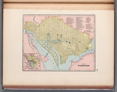
Full Title
Map of Washington.
List No
14372.272
Note
Map of Washington, D.C. Shows political boundaries, railroads, streets, bridges, parks, bodies of water, drainage, shorelines and islands. Map indexed to indicate place names, with index at upper right. Inset map: District of Columbia. Colored lithograph. Map is 22 x 29 cm, on sheet 33 x 45 cm.
Author
Cram, George Franklin, 1841-1928
Full Title
Greater New York.
List No
14372.278
Note
Map of New York City, New York, with all five boroughs and vicinity. Shows political boundaries, cities, railroads, streets, bridges, parks, bodies of water, drainage, coastlines and islands. Includes a bar scale, given in miles. Colored lithograph. Map is 27 x 34 cm, on sheet 33 x 45 cm.
Author
Cram, George Franklin, 1841-1928
Full Title
Council Bluffs.
List No
14372.287
Note
Map of Council Bluffs, Iowa. Shows political boundaries, railroads, streets, bridges, parks, bodies of water, drainage, shorelines and islands. Colored lithograph. Map is 30 x 26 cm, on sheet 45 x 33 cm.
Author
Cram, George Franklin, 1841-1928
Full Title
Map of the United States of America.
List No
14372.291
Note
Map of the United States. Shows political boundaries, cities, railroads, topography, bodies of water, drainage, shorelines and islands. Relief shown with hachures. Includes latitudinal and longitudinal lines. Inset map: Alaska. Colored lithograph. Map is 32 x 49 cm, on double sheet 45 x 67 cm.
Author
Cram, George Franklin, 1841-1928
Full Title
Denver.
List No
14372.292
Note
Map of Denver, Colorado. Shows political boundaries, railroads, streets, bridges, parks, bodies of water, drainage and shorelines. Colored lithograph. Map is 26 x 33 cm, on sheet 33 x 45 cm.
Author
Cram, George Franklin, 1841-1928
Full Title
New Orleans.
List No
14372.302
Note
Map of New Orleans, Louisiana. Shows political boundaries, railroads, streets, bridges, ferry lines, parks, topography, bodies of water and drainage. Relief shown with hachures. Includes a legend, compass rose with north oriented toward top of sheet, as well as a bar scale given in miles. Map indexed to indicate place names. Colored lithograph. Map is 28 x 24 cm, on sheet 45 x 33 cm.
Author
Cram, George Franklin, 1841-1928
Full Title
Chart of the world on Mercator's Projection.
List No
14372.316
Note
Map of the world on Mercator's Projection. Shows political boundaries, cities, railroads, topography, bodies of water, drainage, coastlines, islands and ocean currents. Relief shown with hachures. Maps include latitudinal and longitudinal lines. Provides figures for square milage and population. Six inset maps: Principal cities of the old world : London -- Paris -- Berlin -- St. Petersburg -- Vienna -- Cairo. With statistical tables on national wealth, debts and militaries in margin. Colored lithograph. Map is 38 x 44 cm, on double sheet 45 x 67 cm.
Author
Cram, George Franklin, 1841-1928
Full Title
Chart of the world showing distances saved by the Interoceanic Canal, of Nicaragua and Costa Rica.
List No
14372.361
Note
Map of the world showing the Interoceanic Canal [Nicaraguan Canal], of Nicaragua and Costa Rica. Shows cities, topography, bodies of water, drainage, coastlines, islands and water routes with distances. Relief shown with hachures. Includes a legend, as well as latitudinal and longitudinal lines. Inset map: [Nicaragua]. With table: Table showing distances in miles between commercial ports of the world and distances saved by the Nicaragua Canal. Colored lithograph. Map is 25 x 40 cm, on sheet 33 x 45 cm.
Author
[Geological Survey (U.S.), Sturtevant, William C.]
Full Title
Early Indian tribes, culture areas, and linguistic stocks / William C. Sturtevant, Smithsonian Institution, 1967.
List No
14359.094
Note
Historical map representing the United States, featuring the territories and cultural areas and languages of early indigenous peoples, as of around 1899. Shows both major and minor tribes, political boundaries (present-day), bodies of water, drainage, coastlines and islands. Includes a legend, latitudinal and longitudinal lines, as well as a bar scale and scale statement. Presented with Albers Equal Area Projection. With two inset maps: Principal islands of Hawaii -- Alaska. Colored lithograph. Map is 43 x 66 cm, on double sheet 49 x 71 cm. Also, with bibliography for further reading. Accompanying descriptive text on page 132. Appears in Special subject maps section, subsection History.
Author
[Geological Survey (U.S.), Sturtevant, William C.]
Full Title
Early Indian tribes, culture areas, and linguistic stocks : [Alaska] / William C. Sturtevant, Smithsonian Institution, 1967.
List No
14359.095
Note
Historical map representing Alaska, featuring the territories and cultural areas and languages of early indigenous peoples, as of around 1899. Shows both major and minor tribes, political boundaries (present-day), bodies of water, drainage, coastlines and islands. Includes a legend, latitudinal and longitudinal lines, as well as a bar scale and scale statement. Presented with Albers Equal Area Projection. Colored lithograph. Map is divided into two parts, together 33 x 32 cm, on sheet 49 x 35 cm. Accompanied by descriptive text, with references. Appears in Special subject maps section, subsection History.
Author
[Suomen Maantieteellinen Seura, Tilgmann, Ferdinand, 1832-1911]
Full Title
(Covers to) Atlas öfver Finland. Sällskapet för Finlands geografi.
List No
14366.001
Note
Covers to Atlas öfver Finland. Bound in dark teal board with reinforced spine. Gilded title on front cover. With gilded coat of arms for Finland, as well as floral ornamentation. Versos of covers have decorative end papers.
Author
[Suomen Maantieteellinen Seura, Tilgmann, Ferdinand, 1832-1911]
Full Title
(Title Page to) Atlas öfver Finland. Sällskapet för Finlands geografi, Helsingfors 1899, Aktiebolaget F. Tilgmanns bok- och stentryckeri.
List No
14366.002
Note
Title page to Atlas öfver Finland. Title translates to: Atlas of Finland. Includes imprint. With coat of arms of Finland, printed in red. (Page number inferred.)
Author
[Suomen Maantieteellinen Seura, Tilgmann, Ferdinand, 1832-1911]
Full Title
No. 1. Suomi. = Finland. Aktiebolaget F. Tilgmann, Helsingfors 1897.
List No
14366.010
Note
Map of Finland. Shows political boundaries, cities, boroughs, villages, railways, highways, churches (Lutheran and Greek Catholic), bodies of water, drainage, coastlines and islands in 1897. Includes latitudinal and longitudinal lines, as well as a legend, bar scale and scale statement given in kilometers. Colored lithograph. Map is 59 x 41 cm, on double sheet 60 x 43 cm. Text presented in parallel Finnish and Swedish.
Author
[Suomen Maantieteellinen Seura, Tilgmann, Ferdinand, 1832-1911]
Full Title
No. 2. Korkeussuhteet. = Höjdförhållanden.
List No
14366.011
Note
Topographic map of Finland. Features elevation heights in 1899. Also shows political boundaries, cities, railways, bodies of water, drainage, coastlines and islands. Relief shown with color coding. Includes latitudinal and longitudinal lines, as well as a legend, bar scale and scale statement given in kilometers. Colored lithograph. Map is 58 x 41 cm, on double sheet 60 x 43 cm. Text presented in parallel Finnish and Swedish.
Author
[Suomen Maantieteellinen Seura, Tilgmann, Ferdinand, 1832-1911]
Full Title
No. 3. Vuoriperä. = Bärggrunden. Aktiebolaget F. Tilgmann, Helsingfors 1897.
List No
14366.012
Note
Geologic map of Finland. Features geology in 1897. Also shows political boundaries, cities, railways, bodies of water, drainage, coastlines and islands. Includes latitudinal and longitudinal lines, as well as a legend, bar scale and scale statement given in kilometers. Colored lithograph. Map is 52 x 37 cm, on double sheet 60 x 43 cm. Text presented in parallel Finnish and Swedish.
Author
[Suomen Maantieteellinen Seura, Tilgmann, Ferdinand, 1832-1911]
Full Title
No. 5. Isotermit : Eri kuukausina ja koko vuonna. 1881-1890. = Isotermer : För månaderna och året. 1881-1890. : Vuosi. = Året -- Tammikuu. = Januari. -- Helmikuu. = Februari. -- Maaliskuu. = Mars. -- Huhtikuu. = April. -- Toukokuu. = Maj. -- Kesäkuu. = Juni. -- Heinäkuu. = Juli. -- Elokuu. = Augusti. -- Syyskuu. = September. -- Lokakuu. = Oktober. -- Marraskuu. = November. -- Joulukuu. = December.
List No
14366.014
Note
Thirteen climate maps of Finland. Maps feature isotherms - lines of the same average temperature over time - in different months and throughout the year, from 1881 to 1890. Maps also show cities, railways, bodies of water, drainage, coastlines and islands. Maps include latitudinal and longitudinal lines. Colored lithograph. Together, maps are 51 x 38 cm, on double sheet 60 x 43 cm. Text presented in parallel Finnish and Swedish.
Author
[Suomen Maantieteellinen Seura, Tilgmann, Ferdinand, 1832-1911]
Full Title
No. 15. Väestö sukupuolen ja ijän mukaan. = Befolkningen efter kön och älder. : 1751. 1775. 1800. -- 1825. -- 1850. -- 1865. -- 1870. -- 1875. (1)
List No
14366.027
Note
Six statistical charts of Finland. Charts feature population according to sex and age, comparing across the entire country, and in cities versus the countryside, from 1751 to 1875. Colored lithograph. Together, charts are 35 x 54 cm, on double sheet 43 x 60 cm. Text presented in parallel Finnish and Swedish. Followed by two more charts - 1880 and 1890 - in the same series on following plate.
Author
[Suomen Maantieteellinen Seura, Tilgmann, Ferdinand, 1832-1911]
Full Title
No. 15. Väestö sukupuolen ja ijän mukaan. = Befolkningen efter kön och älder. : 1880. -- 1890. (2) -- No. 16. Väestö sivilisäädyn ja sukupuolen mukaan. = Befolkningen efter civilstånd och kön. : 1880-1890 -- 1890 : Läänien väkiluku. = Länens folkmängd. -- Läänien pinta-ala. = Länens areal. -- Väentiheys. = Folktäthet.
List No
14366.028
Note
Eight statistical charts of Finland. Charts feature population according to sex and age, marital status and the total population in different counties, from 1751 to 1890. Colored lithograph. Together, charts are 37 x 54 cm, on double sheet 43 x 60 cm. Text presented in parallel Finnish and Swedish. Followed by two more charts - 1751-1800, 1825, 1850, 1865, 1870 and 1875 - in the same series (as the first two charts) on previous plate.
Author
[Suomen Maantieteellinen Seura, Tilgmann, Ferdinand, 1832-1911]
Full Title
No. 17. Väentiheys. = Folktätheten. Aktiebolaget F. Tilgmann, Helsingfors 1897.
List No
14366.029
Note
Statistical map of Finland. Features population density in 1897. Also shows political boundaries, cities, railways, bodies of water, drainage, coastlines and islands. Includes latitudinal and longitudinal lines, as well as a legend, bar scale and scale statement. Colored lithograph. Map is 52 x 40 cm, on double sheet 60 x 43 cm. Text presented in parallel Finnish and Swedish.
Author
[Suomen Maantieteellinen Seura, Tilgmann, Ferdinand, 1832-1911]
Full Title
No. 18. Väestö kaupungeissa ja maaseudulla. = Stads- och Landsbefolkning. -- Väestö äidinkielen mukaan. = Befolkningen efter modersmäl. -- Väestö uskontunnustuksen mukaan. = Befolkningen efter trosbekännelse. -- Sokeita, kuuromykkiä. = Blinde, döfstumme och sinnessvage. -- 10:tä vuotta vanhempi väestö sivistyskannan mukaan. = Befolkningen öfver 10 är ester bildningsgrad. -- Väestö ammatin mukaan. = Befolkningen efter yrke och näring. -- Väestö syntymäpaikan mukaan. = Befolkningen efter födelseort. -- Väestö säädyn mukaan. = Befolkningen efter samhällsstånd.
List No
14366.030
Note
Nine statistical charts of Finland. Charts feature population according urban and rural areas, mother tongue, religion, disabilities, education, occupation, place of birth and social status in 1890. Colored lithograph. Together, charts are 35 x 51 cm, on double sheet 43 x 60 cm. Text presented in parallel Finnish and Swedish.
|
![Karte der grossen Postdampfschifflinien im Weltpostverkehr. [Map of the major postal steamship lines in world postal traffic.]](https://www.davidrumsey.com/rumsey/Size2/RUMSEY~8~1/213/15829001.jpg)
![Covers: Karte der grossen Postdampfschifflinien im Weltpostverkehr. [Map of the major postal steamship lines in world postal traffic.]](https://www.davidrumsey.com/rumsey/Size1/RUMSEY~8~1/213/15829002.jpg)
![Text: Karte der grossen Postdampfschifflinien im Weltpostverkehr. [Map of the major postal steamship lines in world postal traffic.]](https://www.davidrumsey.com/rumsey/Size2/RUMSEY~8~1/213/15829003.jpg)


![Composite Map: Ohio : North half. -- Ohio : [South half].](https://www.davidrumsey.com/rumsey/Size2/RUMSEY~8~1/205/14372067.jpg)


![Early Indian tribes, culture areas, and linguistic stocks : [Alaska].](https://www.davidrumsey.com/rumsey/Size2/RUMSEY~8~1/199/14359095.jpg)


