|
Author
García Cubas, Antonio, 1832-1912
Full Title
(Covers/Title Page to) (Carta itineraria de la Republica, construida para la mejor inteligencia de los anteriores derroteros que unen la Capital con los principales puntos extremos del Territorio). Lit. H. Iriate. (Cover title) Itinerarios y derroteros de la Republica Mexicana con expresion de la distancias en leguas y kilometros. Dispoestos por Antonio Garcia Cubas. Mexico, Imprenta de Francisco Diaz de Leon Calle de Lerdo Numero 3. 1881.
List No
9858.001
Note
Uncolored map, 28x41, folded into booklet with heavy pale green paper covers in 56 pages, including text, itineraries and index. Map shows paths linking the capital with the principal cities and towns.
Author
García Cubas, Antonio, 1832-1912
Full Title
(Composite text) (Carta itineraria de la Republica, construida para la mejor inteligencia de los anteriores derroteros que unen la Capital con los principales puntos extremos del Territorio). Lit. H. Iriate. (Cover title) Itinerarios y derroteros de la Republica Mexicana con expresion de la distancias en leguas y kilometros. Dispoestos por Antonio Garcia Cubas. Mexico, Imprenta de Francisco Diaz de Leon Calle de Lerdo Numero 3. 1881.
List No
9858.002
Note
Uncolored map, 28x41, folded into booklet with heavy pale green paper covers in 56 pages, including text, itineraries and index. Map shows paths linking the capital with the principal cities and towns.
Author
García Cubas, Antonio, 1832-1912
Full Title
(Index Page to) (Carta itineraria de la Republica, construida para la mejor inteligencia de los anteriores derroteros que unen la Capital con los principales puntos extremos del Territorio). Lit. H. Iriate. (Cover title) Itinerarios y derroteros de la Republica Mexicana con expresion de la distancias en leguas y kilometros. Dispoestos por Antonio Garcia Cubas. Mexico, Imprenta de Francisco Diaz de Leon Calle de Lerdo Numero 3. 1881.
List No
9858.003
Note
Uncolored map, 28x41, folded into booklet with heavy pale green paper covers in 56 pages, including text, itineraries and index. Map shows paths linking the capital with the principal cities and towns.
Author
García Cubas, Antonio, 1832-1912
Full Title
(Carta itineraria de la Republica, constuida para la mejor inteligencia de loa anteriores derroteros que unen la Capital con los principales puntos extremos del Territorio). Lit. H. Iriate. (Cover title) Itinerarios y derroteros de la Republica Mexicana con expresion de la distancias en leguas y kilometros. Dispoestos por Antonio Garcia Cubas. Mexico, Imprenta de Francisco Diaz de Leon Calle de Lerdo Numero 3. 1881.
List No
9858.004
Note
Uncolored map, 28x41, folded into booklet with heavy pale green paper covers in 56 pages, including text, itineraries and index. Map shows paths linking the capital with the principal cities and towns.
Author
Andriveau-Goujon, E. (Eugène), 1832-1897
Full Title
(Title Page to) Atlas universel de géographie moderne. Publié par E. Andriveau-Goujon, Paris: Rue du Bac, 4.
List No
14008.003
Note
Title page includes table of contents for 25 maps in atlas. Text at bottom of sheet: Paris. - Typ. G. Chamerot. - 8658.
Author
Andriveau-Goujon, E. (Eugène), 1832-1897
Full Title
(1) Mappemonde en deux hémispheres. 1878. Publiée par E. Andriveau-Goujon, Rue du Bac, 4, Paris. Gravé par Ch. Dyonnet; ecrit par P. Rousset; Paris, Impie. de Louis Antoine, Rue des Noyers, 70.
List No
14008.004
Note
Hand-colored, engraved world map in two hemispheres: occidental and oriental (on double plate with decorative border). Includes text at bottom: Colonies Européennes : Angleterre, France, Espagne, Portugal, Hollande, Danemark. "No. 1" in upper right.
Author
Andriveau-Goujon, E. (Eugène), 1832-1897
Full Title
(2) Carte de l'Europe et du Bassin de la Méditerranée. Publiée par E. Andriveau-Goujon, 4, Rue du Bac. Paris, 1879. Paris, Impie. Alfred Chardon Jeune; gravée: la géographie par Smith; les escritures par P. Rousset; les eaux par Mm. Fontaine.
List No
14008.005
Note
Hand-colored, engraved map of Europe and the greater Mediterranean Region, showing political boundaries, roads and railroads (on double plate with decorative border). Includes legend, as well as 10 bar scales and a scale statement. Handwritten annotation in blue ink traces a route in southwestern Germany. "No. 2" in upper right.
Author
Andriveau-Goujon, E. (Eugène), 1832-1897
Full Title
(Composite to) Carte orographique hydrographique et routière de la France comprenant le Bassin du Rhin et la Région des Alpes occidentales réduite de la nouvelle carte de France de l'État-Major dressée au Dépôt de la Guerre. Publiée par E. Andriveau-Goujon, Rue du Bac, 4, Paris, 1881. Gravé sur Acier; le trait par Smith; la topographie par Gérin; les ecritures par P. Rousset; les eaux par Fontaine; Impie. Alfred Chardon Jne.
List No
14008.013
Note
Hand-colored, engraved fold-out map of France, showing political boundaries, roads and railroads (on double plate with decorative border, on two consecutive sheets: 8 and 9). Includes legend, as well as 3 bar scales and a scale statement. With inset: (Bouches de Bonifacio).
Author
Andriveau-Goujon, E. (Eugène), 1832-1897
Full Title
(13) Empire d’Allemagne et pays limitrophes. E. Andriveau-Goujon, éditeur, Rue du Bac, 4, Paris, 1880. Gravé chez L. Wuhrer, rue de l'Abbé de l'Epée 4; Imp. Monroco, Paris.
List No
14008.017
Note
Hand-colored, engraved map of Germany, showing showing political boundaries, roads, railroads and water routes (on double plate). Includes legend, as well as a bar scale and a scale statement. Features a table: Tableau des états de l'Empire d’Allemagne. "Atlas usuel, No. 15" and "Atlas universel, No. 30" in lower left.
Author
Andriveau-Goujon, E. (Eugène), 1832-1897
Full Title
(15) Empire Ottoman et Grèce. Publié par E. Andriveau-Goujon, Rue du Bac, 4, Paris, 1879. Paris, Imp. Alfred Chardon Jne.; gravé: le trait par Smith; la topographie par Gérin; les ecritures par Rousset; les eaux par Mme. Fontaine.
List No
14008.019
Note
Hand-colored, engraved map of the Ottoman Empire and Greece, showing showing political boundaries, roads, railroads and water routes (on double plate with decorative border). Includes legend indicating ethnic divisions, as well 6 bar scales and a scale statement. Features a table: Explication de quelques dénominations géographiques. "No. 15" in upper right. "Atlas usuel, No. 21" and "Atlas universel, No. 54" in lower left.
Author
Andriveau-Goujon, E. (Eugène), 1832-1897
Full Title
(16) Carte physique & politique de l'Asie. Publiée par E. Andriveau-Goujon, 4, Rue du Bac, Paris, 1881. Gravée par Ch. Smith et Gérin; les eaux par Mme. Fontaine; Paris, Impie. Ch. Chardon, ainé, 10, r. de l'Abbaye; la lettre par Isid. Dalmont.
List No
14008.020
Note
Hand-colored, engraved map of Asia, showing showing political boundaries, roads, railroads and water routes (on double plate with decorative border). Includes legend, as well as 10 bar scales. "No. 16" in upper right. "Atlas usuel, No. 21" and "Atlas universel, No. 54" in lower left.
Author
Andriveau-Goujon, E. (Eugène), 1832-1897
Full Title
(18) Palestine ancienne & moderne d'aprés les sources les plus authentiques. Par E. Andriveau-Goujon. Paris, 1876. E. Andriveau-Goujon, éditeur. Rue du Bac, 4. Paris, imprimie. Ch. Chardon; gravé: le trait par Smith; les montagnes par Gérin; les ecritures par P. Rousset; les eaux par Mme. Fontaine.
List No
14008.022
Note
Hand-colored, engraved map of the Holy Land, showing political boundaries, roads and railroads (with decorative border). Includes legend, index, as well as 4 bar scales and a scale statement. Features translations into French. "No. 18" in upper right. "Atlas usuel, No. 23" and "Atlas universel, No. 36" in lower right. With 5 insets: (Egypt; Palestine; Arabie) -- (Golfe de Suez) -- (Niveau de la Méditerranée) -- ([Profile of mountains in vicinity of Jerusalem]) -- Jérusalem d'aprés le plan de G. Williams.
Author
Andriveau-Goujon, E. (Eugène), 1832-1897
Full Title
(19) Carte générale de l'Afrique d'après les derraeres découvertes. Publiée par E. Andriveau-Goujon, 4, Rue du Bac, Paris, 1881. Nouvelle edition. Gravée par Smith et Gérin; les ecritures par P. Rousset.
List No
14008.023
Note
Hand-colored, engraved map of Africa, showing showing political boundaries, roads and railroads (on double plate with decorative border). Includes legend indicating colonies (English, French, Spanish, Portuguese and of the Sultan of Zanzibar), as well as 5 bar scales. "No. 20" in upper right. With 8 insets: (Iles Canaries) -- (Madère) -- (Iles du Cap Vért) -- (Ile de l'Ascension) -- (Ile Ste. Hélène) -- (Ile Mayotte) -- (Iles Nossi-Be) -- (Iles Mascareignes).
Author
Andriveau-Goujon, E. (Eugène), 1832-1897
Full Title
(20) Algérie d'après les cartes de l'état-major et les documents du Ministère de la Guerre. E. Andriveau-Goujon, éditeur. Paris, Rue du Bac, 4, 1880. Paris, Impie. Alfred Chardon jeune; Gravée par Ms. Gérin; Dalmont, Smith et Fontaine.
List No
14008.024
Note
Hand-colored, engraved map of Algeria and greater North Africa, showing showing political boundaries, roads, railroads, water routes and military divisions (on double plate with decorative border). Includes legend, as well as 2 bar scales and a scale statement. "No. 21" in upper right. "Atlas usuel, No. 28" and "Atlas universel, No. 41" in lower right. With inset (indexed to show colonies): Carte d'Ensemble des rapports entre la France, l'Algérie, la Sénégambie et le Nord de l'Afrique.
Author
Andriveau-Goujon, E. (Eugène), 1832-1897
Full Title
(21) Carte de la Basse-Égypte et du Canal Maritime de Suez. Publiée par E. Andriveau-Goujon, éditeur. Rue du Bac, 21, Paris, 1880. Gravé sur pierre et chrom. par P. Méa, 14, r. des Fsés. St. Bernard; Imp. Lemercier et Cie. r. de Seine, 57, Paris.
List No
14008.025
Note
Hand-colored, engraved map of Egypt and greater North Africa, including the Suez Canal, showing showing political boundaries, roads, railroads and water routes (with decorative border). Includes legend, as well as 3 bar scales and a scale statement. "Inauguration du Canal, 17 Novembre 1869" in both upper left and right. With 3 insets: Plan d'Ismaïlia (scale 1:25,000) -- Plan de la Rade de Port Saïd et de l'embouchure du canal dans la Mediterranée (scale 1:60,000) -- Plan de la rade de Suez et de l'embouchure du canal dans la Mer Rouge (scale 1:60,000).
Author
Andriveau-Goujon, E. (Eugène), 1832-1897
Full Title
(22) Carte générale de l'Océanie. Publiée E. Andriveau-Goujon, 4, Rue du Bac, Paris, 1876. Impie. de Louis Antoine; gravé par Ch. Smith et Gérin; les eaux par Mme. Fontaine.
List No
14008.026
Note
Hand-colored, engraved map of Oceania, including the East Indies, Australia, New Zealand, and other others, showing the borders between the seas and oceans (on double plate with decorative border). Includes legend indicating European colonies (English, French, Dutch, Spanish and Portuguese). "No. 22" in upper right. With 3 insets: Iles Nouka-Hiva -- Iles Taïti -- Terres Australes.
Author
Andriveau-Goujon, E. (Eugène), 1832-1897
Full Title
(23) Amérique du Nord. Paris, 1877. E. Andriveau-Goujon, éditeur, Rue du Bac, 4. Gravé chez L. Wuhrer, R. Gay-Lussac, 52, Paris; Imp. Lemercier, Paris.
List No
14008.027
Note
Hand-colored, engraved map of North America, showing railroads, water routes with distances, ocean currents and glaciers (on double plate with decorative border). Includes legend indicating European colonies (English, French, Spanish, Danish, Swedish, Dutch, and American), as well as 4 bar scales and a scale statement. "Longitude ouest du Méridien de Paris". With inset: Iles Aléoutiennes.
Author
Andriveau-Goujon, E. (Eugène), 1832-1897
Full Title
(24) Carte générale des États-Unis et du Mexique comprenant l'Amérique centrale et les Antilles. E. Andriveau-Goujon, éditeur. Paris, Rue du Bac, 4. Nouvelle édition, 1876.
List No
14008.028
Note
Hand-colored, engraved map of the United States, Mexico, Central America and the Antilles, showing railroads and water routes (on double plate with decorative border). Includes legend indicating European colonies (French, English, Dutch, Danish, Spain and Swedish), as well as 4 bar scales. "No. 24" in upper right. With 4 insets: États de l'Amérique Centrale -- Entré de New-York -- Carte des rapports entre l'Europe & l'Amérique -- Petites Antilles et Nord de l'Amérique du Sud.
Author
Andriveau-Goujon, E. (Eugène), 1832-1897
Full Title
(25) Amérique du Sud. E. Andriveau-Goujon, éditeur, 4, Rue du Bac, Paris, 1878. Gravé chez L. Wuhrer, Rue de l'Abbé de l'Epée 4; Paris, Imp. F. Dufrenoy.
List No
14008.029
Note
Hand-colored, engraved map of South America, showing railroads, water routes with distances, ocean currents and glaciers (on double plate with decorative border). Includes legend indicating European colonies (French, English and Dutch), as well as 5 bar scales and a scale statement. "Longitude ouest du Méridien de Paris". With inset: Iles Galapagos (Dépendance de la République de l'Équateur).
Author
[Estéban PICHARDO y Tapia (1799 - 1879), VALDEPARES, Jose]
Full Title
Plano de la Habana por D. Estéban T. Pichardo, agrimensor y maestro de obras. / Editor: D. Jose Valdepares. / 1881.
List No
15447.000
Author
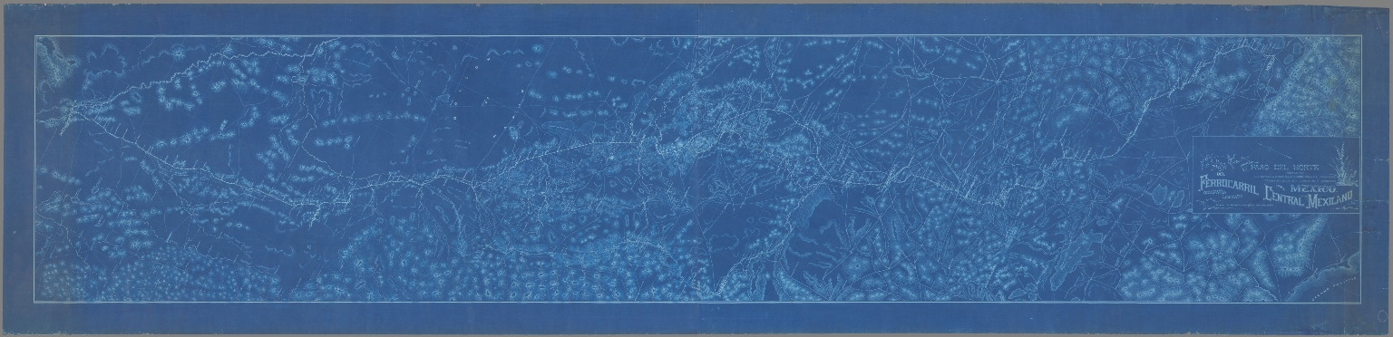
FERROCARRIL CENTRAL MEXICANO COMPAÑIA LIMITADA
Full Title
Mapa del Ferrocarril Central Mexicano desde Paso del Norte pasando por los estados de Chihuahua, Durango, Coahuila, Zacatecas, Aguascalientes, Jalisco, Guanajuato y Queretaro hasta Mexico
List No
15439.000
Note
Date estimated.
Author
[S.F. News Letter, Britton & Rey]
Full Title
The New California Sugar Refinery, San Francisco. Claus Spreckels, President. Issued with the S.F. News Letter, Christmas Number 1881.
List No
15129.000
Author
[France. Ministère des travaux publics. Administration des routes, France. Direction des cartes, plans et archives et de la statistique graphique, École nationale des ponts et chaussées (France)]
Full Title
Wellington, 1881 (Nelle Zélande). 6e Série. Pl. X. Ministère des Travaux Publics. Ecole des Ponts et Chaussées. Lith. A. Simon, 13, R. du Val-de-Grâce. Paris.
List No
14306.153
Note
Map showing the port of Wellington, New Zealand, in 1881. Features topography, railways, streets, bridges, drainage, docks and soundings, with depths given in meters. Relief shown with hachures. Includes a bar scale and compass rose, with north oriented toward top-left of sheet. Descriptive text throughout. Lithograph in black, white and blue. Map is 29 x 46 cm, on sheet 33 x 50 cm. Bookplate title pasted to verso: Pl. X. Wellington. Appears in Sixième livraison.
Author
Spielmann and Brush
Full Title
(Title Page to) Certified copies of original maps of property in New York City, filed in the Register's Office and elsewhere, together with the Register's index to maps and important notes regarding the same. Published by Spielmann & Brush, civil engineers, Hoboken, N.J. 1881.
List No
13338.002
Author
Spielmann and Brush
Full Title
Turtle Bay Farm : filed January 1835 by John Beveridge, D. B. Tallmadge. Published by Spielmann & Brush, civil engineers, Hoboken, N.J. 1881. (to accompany) Certified copies of original maps of property in New York City.
List No
13338.009
Note
Hand colored cadastral map. Includes notes and names of adjoining landholders.
Author
Spielmann and Brush
Full Title
Map of West Bayard Farm : The property of Nicholas and Stephen Bayard. Surveyed and laid out into lots. By Casimir Th. Goerck, City Surveyor; New York 1788. Published by Spielmann & Brush, civil engineers, Hoboken, N.J. 1881. (to accompany) Certified copies of original maps of property in New York City.
List No
13338.010
Note
Hand colored cadastral map. Includes notes and names of adjoining landholders. Oriented with north to the upper right.
Author
Spielmann and Brush
Full Title
Map of a tract of land commonly called the Hermitage : Situated in the ninth ward of the City of New York ... Compiled from authentic surveys February 1825 by Daniel Eiven City Surveyor. Published by Spielmann & Brush, civil engineers, Hoboken, N.J. 1881. Copied in the Registrer's Office January 2nd. 1873. (to accompany) Certified copies of original maps of property in New York City.
List No
13338.011
Note
Hand colored cadastral map. Includes notes and names of adjoining landholders. "Showing the same a subdivided into lots on the intersecting avenues and streets". Oriented with north to the upper center.
Author
Spielmann and Brush
Full Title
Map of property belonging o S. Benson and B. Vredenbergh, Decd. in the Twelfth Ward of the City of New York. Copied in the Registrer's Office, City of New York; Dec. 20nd. 1872. Published by Spielmann & Brush, civil engineers, Hoboken, N.J. 1881. (to accompany) Certified copies of original maps of property in New York City.
List No
13338.012
Note
Hand colored cadastral map. Includes notes and names of adjoining landholders. Oriented with north to the upper left.
Author
Spielmann and Brush
Full Title
3d. Ave. Tract. Published by Spielmann & Brush, civil engineers, Hoboken, N.J. 1881. (to accompany) Certified copies of original maps of property in New York City.
List No
13338.013
Note
Hand colored cadastral map on 2 sheets. Includes notes and names of adjoining landholders. Oriented with north to the upper right.
Author
France. Ministere de l'interieur. Service de la carte de France et de la statistique graphique
Full Title
(Title Page to) Ministere de l'interieur : Service de la carte de France et de la statistique graphique. : Album de statistique graphique. 1881.
List No
13086.002
Note
Statistical atlas of France. Contains 16 maps and 19 diagrams, relating to the enumeration of the population, local roads, transportation, French emigration, hospices and charitable offices, children in attendance, and elections. Covered in quarter bound with linen on tan cardboard boards.
Author
France. Ministere de l'interieur. Service de la carte de France et de la statistique graphique
Full Title
Population ... 1851-1876. Dressee d'apres les renseignements fournis par le 1er. Bureau de la Division de l'Administration generale et departmentale. Grave par Erhard, Paris. Imp. Erhard. (in upper margin) Ministere de l'interieur : Administration departemmentale et communale. Statistique graphique - 1881. (inset) Corse.
List No
13086.004
Note
Color map of France, Shows administrative divisions. With color coded statistical table.
Author
France. Ministere de l'interieur. Service de la carte de France et de la statistique graphique
Full Title
Densite de la population. Dressee d'apres les renseignements fournis par le 1er. Bureau de la Division de l'Administration generale et departmentale. Grave par Erhard, Paris. Imp. Erhard. (in upper margin) Ministere de l'interieur : Administration departemmentale et communale. Statistique graphique - 1881. (inset) Corse.
List No
13086.005
Note
Color map of France, Shows administrative divisions. With color coded statistical table showing population density.
Author
France. Ministere de l'interieur. Service de la carte de France et de la statistique graphique
Full Title
Nombre de communes par departement. Dressee d'apres les renseignements fournis par le 1er. Bureau de la Division de l'Administration generale et departmentale. Grave par Erhard, Paris. Imp. Erhard. (in upper margin) Ministere de l'interieur : Administration departemmentale et communale. Statistique graphique - 1881. (inset) Corse.
List No
13086.006
Note
Color map of France, Shows administrative divisions. With color coded statistical table.
Author
[Firket, Adolphe Georges Auguste, Jochams, Felix]
Full Title
Carte de la production, de la circulation, de la consommation des minerais et de la production des metaux en Belgique pendant l'annee 1878. Dressee a l'aide de documents officiels et de renseignements speciaux recueillis par M. F. Jochams, inspecteur - general de mines, par Adolphe Firket .... Institut Cartographique Militaire 1881.
List No
11709.001
Note
Color map of Belgium 73x87, dissected into 24 sections of 18x14, backed with linen. Showing production, circulation, consumption of minerals and the production of metals in Belgium during 1878. Includes color coded signs showing production, consumption and transportation of minerals, and Table of mines, minerals, factories and production of iron, zinc, lead, copper or pyrite minerals in 1878. Map showing cities, villages, roads, railroads, rivers, canals, etc. Includes legend and text. This flow diagram was likely influenced by the work of Charles Joseph Minard.
Author
Brownell, F.C.
Full Title
(Title page to) How to Use Globes in the School and Family. Thirteenth Edition.
List No
10054.002
Author
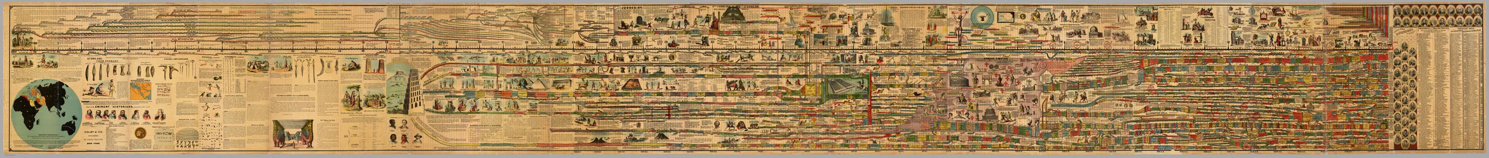
Adams, Sebastian C.
Full Title
(Composite of) Adams' Synchronological Chart of Universal History. Through the Eye to the Mind. A Chronological chart of Ancient, Modern and Biblical History, Synchronized by Sebastian C. Adams. Third Edition and Twelfth-Thousand carefully and critically revised and brought down to 1878. Colby & Co. Publishers, 39 Union Square, New York. The Strowbridge Lithographing Company, Cincinnati, O. Entered According to Act of Congress in the Year A.D. 1871, by S.C. Admas, in the Office of the Librarian of Congress at Washington, D.C. (On the title page) Adams' Synchronological Chart of Universal History...Through the Eye to the Mind.
List No
6000.013
Note
A huge and impressive twenty three foot long chart showing 5,885 years of history, from 4004 B.C.. to 1881 A.D. First issued in 1871, Adams put out several editions in many formats. Rosenberg and Grafton in "Cartographies of Time" say that as a timeline, Adams Synchronological Chart "was ninetheenth-century America's surpassing achievement in complexity and synthetic power."
Author
[Alaskan Boundary Tribunal, Dawson, Wm. Bell]
Full Title
(Facsimile) Geological Survey of Canada, Alfred R.G. Selwyn, LL.D., F.R.S. Director. Map of Part of British Columbia and the North West Territory from the Pacific Ocean to Fort Edmonton (portion). To Illustrate Report by George M. Dawson. D.S., A.R.S.M., F.G.S. 1879-80. Compiled and Drawn by Wm. Bell Dawson, Ma.E., Assoc. M. Inst.C.E. Alaskan Boundary Tribunal, 1903. 41. Andrew B. Graham. Photo-Litho. Washington.D.C.
List No
0009.084
Note
Relief shown by hachures.
Author
Cram, George Franklin
Full Title
(Covers to) Cram's Railroad & County Map Of Virginia, W. Virginia, Maryland & Delaware. Published By Geo. F. Cram. Proprietor Of The Western Map Depot. 262-264 Wabash, Ave. Chicago, Ills. 1881. Entered ... 1878, by G.F. Cram... Washington D.C.
List No
0209.001
Note
From the New Commercial Atlas of the U.S. 1875. Folded into brown cloth covers 14x9 with "Indexed Railroad And County Map Virginia W. Va. Md. & Delaware Published By Geo. F. Cram. Chicago" in gilt. Full color. Relief shown by hachures.
Author
Cram, George Franklin
Full Title
Cram's Railroad & County Map Of Virginia, W. Virginia, Maryland & Delaware. Published By Geo. F. Cram. Proprietor Of The Western Map Depot. 262-264 Wabash, Ave. Chicago, Ills. 1881. Entered ... 1878, by G.F. Cram... Washington D.C.
List No
0209.002
Note
From the New Commercial Atlas of the U.S. 1875. Folded into brown cloth covers 14x9 with "Indexed Railroad And County Map Virginia W. Va. Md. & Delaware Published By Geo. F. Cram. Chicago" in gilt. Full color. Relief shown by hachures.
Author
[Gray, Frank A., Gray, O.W.]
Full Title
Gray's New Map of North Carolina and South Carolina by Frank A. Gray. Entered ... 1881 by O.W. Gray & Son. (insert) Charleston Harbor and its Approaches.
List No
0312.024
Author
[Gray, Frank A., Gray, O.W.]
Full Title
Gray's New Map of Wisconsin by Frank A. Gray. Entered ... 1881 by O.W. Gray & Son.
List No
0312.042
Author
[Gray, Frank A., Gray, O.W.]
Full Title
Gray's New Map of Chicago by Frank A. Gray. Copyright 1881 by O.W. Gray & Son.
List No
0312.043
Author
[Gray, Frank A., Gray, O.W.]
Full Title
Gray's New Map of Kansas by Frank A. Gray. Entered ... 1881 by O.W. Gray & Son.
List No
0312.047
Author
Brownell, F.C.
Full Title
(Covers to) How to Use Globes in the School and Family. Thirteenth Edition.
List No
10054.001
Author
Brownell, F.C.
Full Title
(Coomposite text) How to Use Globes in the School and Family. Thirteenth Edition.
List No
10054.003
Author
[Ministere des Travaux Publics, Cheysson, Émile]
Full Title
(Covers to) Direction des Cartes, Plans et Archives, et de la Statistique Graphique. Juillet 1881. Paris. Imprimerie Nationale. 1881.
List No
12512.001
Note
Pale green paper-covered boards. Title page text in black on front cover. Text in black on spine, "Album de Statistique Graphique - 1881".
Author
[Ministere des Travaux Publics, Cheysson, Émile]
Full Title
(Half Title Page) Album de Statistique Graphique.
List No
12512.002
Author
[Ministere des Travaux Publics, Cheysson, Émile]
Full Title
(Title Page) Ministere des Travaux Publics. Direction des Cartes, Plans et Archives, et de la Statistique Graphique. Juillet 1881. Paris. Imprimerie Nationale. 1881.
List No
12512.003
Author
[Ministere des Travaux Publics, Cheysson, Émile]
Full Title
(Text Page) Notice.
List No
12512.004
Author
[Ministere des Travaux Publics, Cheysson, Émile]
Full Title
(Text Page) Notice (continued).
List No
12512.005
|