|
Author
Arrowsmith, John
Full Title
Cape of Good Hope, by J. Arrowsmith. London, pubd. 15 Feby. 1836 by J. Arrowsmith, 35 Essex Street, Strand.
List No
0036.024
Note
Engraved map. Hand colored boundaries. Relief shown by hachures. Northeastern part on separate sheet, pasted on. "This map is with permission copied from the original M.S. drawing in the Colonial Office, compiled by Mr. Herbert, Senr."
Author
Brue, Adrien Hubert, 1786-1832
Full Title
(Carte detaillee en deux feuilles de l'Afrique et des iles qui en dependent). Afrique meridionale (par A. Brue, Geographe du Roi ... Paris, 1828). (with) Extremite sud de l'Afrique ou Colonie du cap, pays des Hottentots et des Betjouanas. (with) Archipel du nord-est de Madagascar. (Chez l'Auteur, rue des Macons-Sorbonne, no. 9, et chez les principaux marchands de cartes geographiques)
List No
0096.053
Note
Hand colored engraved map. Relief shown by hachures. Also includes insets of Ascension, Tristan de Acuna and Diego Aloarez, Bouvet, Crozet, Amsterdam and Saint Paul, Kerguelen, and Isles Mascareignes. Prime meridian: Paris.
Author
Brue, Adrien Hubert, 1786-1832
Full Title
(Composite of) Carte detaillee en deux feuilles de l'Afrique et des iles qui en dependent ... par A. Brue, Geographe du Roi ... Paris, 1828. (with) Abyssinie et pays des Gallas. (with) Extremite sud de l'Afrique ou Colonie du cap, pays des Hottentots et des Betjouanas. (with) Archipel du nord-est de Madagascar. Chez l'Auteur, rue des Macons-Sorbonne, no. 9, et chez les principaux marchands de cartes geographiques.
List No
0096.054
Note
Digital composite of 2 hand colored engraved maps (north and south sheet). Relief shown by hachures. Includes inset of Cape Verde, Ascension, Tristan de Acuna and Diego Aloarez, Bouvet, Crozet, Amsterdam and Saint Paul, Kerguelen, and Isles Mascareignes. Prime meridian: Paris.
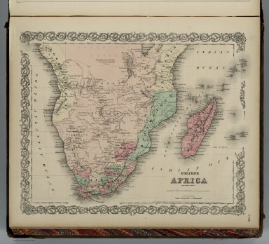
Author
Colton, G.W.
Full Title
Colton's Africa Southern Sheet. Published By J. H. Colton. No. 172 William St. New York.
List No
0151.105
Note
Prime meridians are Greenwich and Washington D.C. Relief shown by hachures.
Author
Colton, G.W.
Full Title
Colton's Africa Southern Sheet. Published By G. W & C. B. Colton & Co. No. 172 William St. New York.
List No
0152.107
Note
Prime meridians are Greenwich and Washington D. C.
Author
Johnston, Alexander Keith, 1804-1871
Full Title
North-western Africa, comprising Marocco, Algeria & Tunis ... Southern Africa, comprising Cape Colony, Natal, &c. By Keith Johnston, F.R.S.E. Engraved & printed by W. & A.K. Johnston, Edinburgh. William Blackwood & Sons, Edinburgh & London, (1861)
List No
0373.043
Note
Two engraved maps on 1 sheet. Boundaries hand col.; hydrography printed in blue. Relief shown by hachures and spot heights. Scales: North-western Africa 1:4,522,426, Southern Africa 1:3,651,858. "Keith Johnston's general atlas 38."
Author
Pinkerton, John, 1758-1826
Full Title
Southern Africa. Drawn under the direction of Mr. Pinkerton by L. Hebert. Neele sculpt. 352 Strand. London: published July 4th, 1809, by Cadell & Davies, Strand & Longman, Hurst, Rees, Orme, & Brown, Paternoster Row.
List No
0732.061
Note
Engraved map. Full hand col. Relief shown by hachures. Includes Madagascar and Comoro Islands. "Pinkerton's modern atlas."
Author
Thomson, John
Full Title
North Africa. South Africa. Engd. by W. Dassauville, Edinr. Drawn and engraved for Thomson's New general atlas, 1815.
List No
1007.054
Note
Two engraved maps on 1 sheet. Hand colored. Relief shown by hachures. Label with "No. 49" affixed to upper left corner.
Full Title
South Africa. (Published at the office of "The Times," London, 1895)
List No
1010.069
Note
Color map with inset. Relief shown by hachures and spot heights. Show settlements, railroads, telegraph lines, etc.
Full Title
Africa, south of the Equator. (Published at the office of "The Times," London, 1895)
List No
1010.072
Note
Color map. Relief shown by hachures and spot heights. Shows settlements, railroads, etc.
Author
[Touring club italiano, Funk & Wagnalls Company.]
Full Title
Colonia del Capo, Cape of Good Hope. Propr. Artistico-letteraria del T.C.I. Ufficio cartografico del T.C.I. (1929)
List No
1012.064
Note
Color map. Relief shown by hachures and spot heights; depths by isolines. Includes insets at 1:250,000 and 1:1,500,000 scale of the Cape Town region.
Author
[Touring club italiano, Funk & Wagnalls Company.]
Full Title
(Legend to) Colonia del Capo. America Settentrionale fisica. Propr. Artistico-letteraria del T.C.I. Ufficio cartografico del T.C.I. (1929)
List No
1012CJ
Note
Explanation to maps (2 facing sheets)
Author
[Ptolemy, Claudius, D'Angelo, Jacopo, Regiomontanus, Joannes, Pirckheimer, Willibald, Grueninger, Johann]
Full Title
(Ta. Mo. Secunda Partis Aphricae.)
List No
10891.112
Author
[Ptolemy, Claudius, Ruscelli,Girolamo, Rosaccio, Giuseppe]
Full Title
Africa Nvova tavola. Descrittione dell' Africa. Libro Secondo. (to accompany) Geographia di Clavdio Tolomeo alessandrino, tradotta di Greco nell'idioma volgare Italiano da Girolamo Ruscelli ... In Venetia, MDXCIX (1599) Appresso gli heredi di M. Sessa.
List No
11299.058
Note
Engraved map of South Africa. Relief shown pictorially.
Author
[Ptolemy, Claudius, Ruscelli, Girolamo, Giuseppe Moletti, M.]
Full Title
Africa Nvova tavola. Africa nvova, Ventesimaseconda nvova tavola. (To accompany) La geografia di Claudio Tolomeo Alessandrino, nuouamente tradotta di Greco in Italiano, da Girolamo Ruscelli ... In Venetia, Appresso Vincenzo Valgrisi, M.D.LXI. (1561).
List No
11311.107
Note
Engraved map of South Africa. Relief shown pictorially.
Author
[Ptolemy, Claudius, Gastaldi, Giacomo, Mattioli, Pietro Andrea, 1500-1577, Pedrezano, Giovanbattista]
Full Title
Africa Nova tabula. (to accompany) Ptolemeo. La geografia di Claudio Ptolemeo alessandrino ... In Venetia, ... per Gioan. Baptista Pedrezano ... Anni x. M.D.XLVIII (1548).
List No
11479.079
Note
Engraved modern map of Southern part of Africa. Shows cities, towns, landmarks, rivers and mountains. Relief shown pictorially.
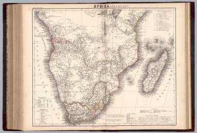
Author
[Sohr, Karl, Berghaus, Heinrich, 1797-1884, Handtke, Friedrich, 1815-1879, Klein, H.J.]
Full Title
Sudliches Afrika. Blatt IV. Druck und Verlag von C. Flemming in Glogau. (to accompany) Sohr-Berghaus Hand-Atlas uber alle Theile der Erde. Neu bearbeitet von F. Handtke, Achte vermehrte und verbesserte Auflage. No. 85. (inset) Togo-Gebiet und Sklavenkuste.
List No
11640.093
Note
Outline color lithograph engraving double page map of Southern Africa, color coded by European possessions. Relief shown by hachures. Prime meridians are Greenwich, Paris and Ferro.
Author
[Sohr, Karl, Berghaus, Heinrich, 1797-1884, Handtke, Friedrich, 1815-1879]
Full Title
Suedliches Afrika. Druck und Verlag von Carl Flemming. (to accompany) Sohr-Berghaus Hand-Atlas ... von F. Handtke, 7. Auflage. Ausgabe. 1884.
List No
11653.095
Note
Engraved lithograph outline hand color map of Southern part of Africa. Relief shown by hachures. Prime meridians are Paris and Ferro.
Author
[Arrowsmith, John, 1790-1873, Stanford, Edward, 1827-1904]
Full Title
South Africa. London: Published 1st. Octr. 1884, by Edward Stanford, 55 Charing Cross. Engraved at Stanfors Geographical Establishment, London. (to accompany) Stanford's London Atlas Of Universal Geography. Folio edition.
List No
11741.045
Note
Outline hand color folded map. Showing political and administrative divisions, cities, towns, railroads, roads, military posts and forts, missionary stations, canals, mountains and rivers. Relief shown by hachures. Prime meridian is Greenwich. Includes legend, reference and abbreviations.
Author
[Wyld, James, 1812-1887, Wyld, James, 1790-1836]
Full Title
Cape District : Cape of Good Hope. London. Published by James Wyld. 1838. (to accompany) A new general atlas of modern geography : consisting of a complete collection of maps of the four quarters of the globe ...
List No
13170.052
Note
Engraved map, hand colored in outline, with decorative title cartouche. Scale in Dutch and British miles, nautical leagues.Shows major cities and towns. Relief shown pictorially and by hachures.
Author
[Meyer, Herrmann Julius, 1826-1909., Ravenstein, Ludwig]
Full Title
Afrika, Sudliches Blatt. Gez. E.G. Revenstein in London. Corr. I. Gest. v. Kern. Stich, Druck und verlag des Bibliographischen Instituts zu Hildburghausen. (to accompany) Meyer's Hand-Atlas ... 1872.
List No
13324.111
Note
Three of 3 sheets. Outline hand colored map. Showing political and administrative boundaries, major cites, towns, roads, rivers and mountains. Relief shown by hachures. Includes legend and color coded key to European possessions in Africa.
Author
[Pasa, Ali Seref, Esref, Hafiz Ali]
Full Title
Kongo hükümeti mustaqilsi = Congo Independent States. 1310 (1894). Tabie ve Nnashiri Hasan Ferid. (to accompany) Yeni cografya atlasi - ىگى جغرافىا آطلسى = New geographical atlas. Dersa'adet (Istanbul), 1307-1309 (1891-1893).
List No
13621.032
Note
Map of Central and South Africa, Covers Congo Democratic Republic, Zanzibar and Mozambique.
Author
[3, Soviet Union. Glavnoe upravlenie geodezii i kartografii]
Full Title
Южная Африка = IUzhnaia Afrika. 206-207. Atlas Mira : 1954.
List No
13682.220
Note
Political and physical map of South Africa and islands of Mascarene. Relief shown by gradient tints and spot heights. Depths shown by gradient tints, isolines and soundings.
Author
[3, Soviet Union. Glavnoe upravlenie geodezii i kartografii]
Full Title
Южно-Африканский Союз (Восток). Южно-Африканский Союз (Юг) = IUzhno-Afrikanskiy Soiuz (Vostok). IUzhno-Afrikanskiy Soiuz (Iug). 208. Atlas Mira : 1954.
List No
13682.221
Note
2 maps on 1 sheet. Relief shown by gradient tints and spot heights. Depths shown by gradient tints, isolines and soundings.
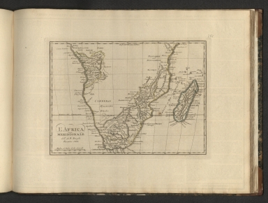
Author
Borghi, Bartolomeo, 1750-1821
Full Title
L'Africa Meridionale, dell'A. B. Borghi. Firenze 1818.
List No
14255.152
Note
Engraved political map of Southern Africa, with hand-colored outlines delineating boundaries. Title translates to: [Southern Africa]. Shows political boundaries, topography, drainage, coastlines, islands and routes of travel. Relief shown pictorially. With latitudinal and longitudinal lines, as well as a bar scale. Imprint beneath title. Map is 21 x 29 cm, on sheet 35 x 47 cm. Descriptive text appears on prior plate (144).
Author
Cram, George Franklin, 1841-1928
Full Title
South Africa, Cape Colony, Natal, Orange Free State and South African Republic.
List No
14372.350
Note
Map of Southern Africa, including South Africa. Shows political boundaries, cities, railroads, submarine telegraph lines, topography, deserts, bodies of water, drainage, coastlines, islands and water routes with distances. Relief shown with hachures and peak heights. Includes latitudinal and longitudinal lines, as well as a bar scale given in miles and explanatory notes throughout. Provides figures for square milage and population. Map indexed to indicate place names. olored lithograph. Map is 23 x 31 cm, on sheet 45 x 33 cm.
Author
[Elwe, Jan Barend, L'Isle, Guillaume de, 1675-1726]
Full Title
Carte de l'Afrique Meridionale ou pays entre la ligne & le cap de Bonne Esperance, et l'Isle de Madagascar. A Amsterdam. Chés J. B. Elwe. MDCCXCII.
List No
14478.050
Note
Map of Southern Africa and vicinity, including the Cape of Good Hope and Madagascar. Shows countries, regions, cities, topography, vegetation, deserts, bodies of water, drainage, coastlines and islands. Relief shown pictorially. Includes a compass rose with north oriented toward top of sheet, a bar scale, latitudinal and longitudinal lines, and descriptive notes throughout. Inset maps Elevation du Port et Mont Table au Cap de Bonne Esperance -- Plan du Port et Mont Table au Cap de Bonne Esperance -- [De Bay Falso]. Hand-colored engraving. Map is 49 x 57 cm, on double sheet 58 x 70 cm. First of three sheets.
Author
[Andree, Richard, Scobel, Albert]
Full Title
Mittel- und Sud- Afrika. Okt. 1905. Bearb. v. K. Tanzler u. G. Jungk. Lithogr. v. H. Anschutz, M. Endlich u. A. Soeder. Flachentreuer azimutaler Entwurf (Hauptpunkt 15 (degree) 30' s. Br., 25 (degree) o. L.). (insets-nebenkarten) Unterer Kongo ; Madagaskar.
List No
1463.092
Note
Outline color map with 2 insets on 2 sheets. Shows settlements, telegraph cables, etc. Colonies shown in color. Includes list of regions, and districts in Congo. Relief shown by hachures and spot heights. Depth shown by bathymetric tints and soundings. Prime meridian is Greenwich.
Full Title
Senegambien. Goldkuste und Kapland: Goldkuste u. Niger Delta, Sud-Afrika. (Richard Andree. Herausgegeben von der Geographischen Anstalt von Velhagen & Klasing in Leipzig. 1881)
List No
1494.072
Note
Three colored maps on 1 sheet. Relief shown by hachures and spot heights. Show settlements, tribes, colonial boundaries, railroads, roads, rivers, missions, etc. Sud-Afrika map at 1:13,250,000 scale.
Author
Colton, G.W.
Full Title
Colton's Africa, Southern Sheet. Published By G. W & C. B. Colton & Co., No. 182 William St. New York.
List No
1550.105
Note
Prime meridians are Greenwich and Washington D. C.
Author
Debenham, Frank
Full Title
The Southern Half of Africa. (Copyright) G.P. Ltd. (inset map and views).
List No
1794.033
Note
Color relief map with text. Relief shown by gradient tints and spot heights. Inset map " Africa lies further away from Antarctica than South America or Australia".
Author
Tanner, Henry Schenck
Full Title
Cape of Good Hope. (to accompany) Atlas Modern. (The Cyclopedia; or, Universal Dictionary of Arts, Sciences, and Literature. 41 vol, 6 vol. of Plates, Ancient and modern atlas.)
List No
2076.036
Note
Engraved double page map. Shows boundaries and division, coastal detail, major cities rivers and mountains. Prime meridian is Greenwich. Relief shown by hachures.
Author
[Geographisches Institut (Weimar, Germany), Kiepert, Heinrich, 1818-1899, Weiland, Carl Ferdinand, 1782 -1847]
Full Title
Nieder-Guinea und das Innere Westlichen Mittel-Africa. (with) Die Insel St. Helena. Gezeichnet von C.F. Weiland, berichtigt 1846 von H. Kiepert. Weimar, im Verlage des geogr. Instituts, 1846.
List No
2077.055
Note
Engraved map. Outline hand col. Prime meridians: Paris and Ferro.
Author
[Geographisches Institut (Weimar, Germany), Kiepert, Heinrich, 1818-1899, Weiland, Carl Ferdinand, 1782 -1847]
Full Title
Die Sudspitze von Africa mit der Colonie am Vorgebirge der guten Hoffnung und dem Kaffern-Lande. (with) Die Halbinsel am Vorgebirge der guten Hoffnung nach Owen u. Vidal. Nach C.F. Weilands, Entwurf, berichtigt von H. Kiepert. Weimar, im Verlage des geograph. Instituts, 1854.
List No
2077.058
Note
Engraved map. Outline hand col. Relief shown by hachures and spot heights. Prime meridians: Paris and Ferro.
Author
[Bartholomew, J. G. (John George), 1860-1920, John Bartholomew and Son]
Full Title
Central & Southern Africa. The Edinburgh Geographical Institute, John Bartholomew & Son, Ltd. "The Times" atlas. (London: The Times, 1922)
List No
2113.079
Note
Col. map. Relief shown by hypsometric tints and spot heights; depths by bathymetric tints. Shows shipping routes with distances, etc.
Author
[Bartholomew, J. G. (John George), 1860-1920, John Bartholomew and Son]
Full Title
South Africa. The Edinburgh Geographical Institute, John Bartholomew & Son, Ltd. "The Times" atlas. (London: The Times, 1922)
List No
2113.081
Note
Col. map. Relief shown by hypsometric tints; depths by bathymetric tints. Shows shipping routes with distances, etc.
Author
[Bartholomew, J. G. (John George), 1860-1920, John Bartholomew and Son]
Full Title
Cape Province, Transvaal, &c. - western section. (with) Cape Town. (with Cape Town Region). The Edinburgh Geographical Institute, John Bartholomew & Son, Ltd. "The Times" atlas. (London: The Times, 1922)
List No
2113.082
Note
Col. map. Relief shown by hypsometric tints and spot heights; depths by bathymetric tints. Shows shipping routes with distances, etc. Scale of insets: Cape Town 1:42,240, Cape Town Region (ca. 1:181,000)
Author
[Bartholomew, J. G. (John George), 1860-1920, John Bartholomew and Son]
Full Title
Cape Province, Transvaal, &c. - eastern section. (with) Port Elizabeth. (with) Durban. The Edinburgh Geographical Institute, John Bartholomew & Son, Ltd. "The Times" atlas. (London: The Times, 1922)
List No
2113.083
Note
Col. map. Relief shown by hypsometric tints and spot heights; depths by bathymetric tints. Shows shipping routes with distances, etc. Scale of insets 1:42,240.
Author
[Bartholomew, J. G. (John George), 1860-1920, John Bartholomew and Son]
Full Title
(Composite of) Cape Province, Transvaal, &c. The Edinburgh Geographical Institute, John Bartholomew & Son, Ltd. "The Times" atlas. (London: The Times, 1922)
List No
2113.084
Note
Composite of 2 col. maps. Relief shown by hypsometric tints and spot heights; depths by bathymetric tints. Shows shipping routes with distances, etc. Includes insets.
Author
Bradford, Thomas G.
Full Title
(Text Page to) Southern Africa. (to accompany) A Comprehensive Atlas, Geographical, Historical & Commercial. By T.G. Bradford. Boston: American Stationers' Company. Entered ... 1835, by Thos. G. Bradford ... Massachusetts.
List No
2120.120
Note
Text includes general description of the region. Includes countries, population, inhabitants, history, etc.
Author
Bradford, Thomas G.
Full Title
Southern Africa. (to accompany) A Comprehensive Atlas, Geographical, Historical & Commercial. By T.G. Bradford. Boston: American Stationers' Company. Entered ... 1835, by Thos. G. Bradford ... Massachusetts.
List No
2120.121
Note
Hand color map. Shows countries, regions, cities and towns, rivers, etc. Relief shown pictorially. Prime meridians are Washington and Greenwich.
Author
Vandermaelen, Philippe, 1795-1869
Full Title
Mononomatapa. Afrique no. 46. (Dresse par Ph. Vandermaelen, lithographie par H. Ode. Troisieme partie. - Afrique. Bruxelles. 1827)
List No
2212.192
Note
Hand col. lithographed map. Relief shown by pictorially. Prime meridian: Paris. Covers parts of Zimbabwe, Zambia and Mozambique.
Author
Vandermaelen, Philippe, 1795-1869
Full Title
Mocaranga. Afrique no. 49. (Dresse par Ph. Vandermaelen, lithographie par H. Ode. Troisieme partie. - Afrique. Bruxelles. 1827)
List No
2212.195
Note
Hand col. lithographed map. Relief shown by pictorially. Prime meridian: Paris. Covers parts of Mozambique, Zimbabwe and South Africa.
Author
Vandermaelen, Philippe, 1795-1869
Full Title
Partie de la Caffrerie. Afrique no. 52. (Dresse par Ph. Vandermaelen, lithographie par H. Ode. Troisieme partie. - Afrique. Bruxelles. 1827)
List No
2212.198
Note
Hand col. lithographed map. Relief shown by pictorially. Prime meridian: Paris. Covers parts of Mozambique, South Africa and Swaziland. Includes text: Note sur la Caffrerie.
Author
[Geographisches Institut (Weimar, Germany), Graf, Adolf]
Full Title
Sud Africa. Bearbeitet von Adolf Graf. Terrain v. G. Dietrich. Gest. v. G. Haubold. Weimar: Geographisches Institut. (to accompany) Hand - Atlas Der Erde Und Des Himmels.
List No
2595.062
Note
Outline hand color map. Color coded by European possessions. Shows the routes followed by the principal explorers from 1831 to 1862. Also shows cities, towns, roads, rivers, etc. Includes legend and notes. Relief shown by hachures. Prime meridians are Greenwich and Paris.
Author
Bradford, Thomas G.
Full Title
Southern Africa. (to accompany) A Comprehensive Atlas, Geographical, Historical & Commercial. By T.G. Bradford. William D. Ticknor, Boston. Wiley & Long, New-York. Entered ... 1835, by Thos. G. Bradford ... Massachusetts.
List No
2643.122
Note
Outline color map. Shows countries, regions, cities and towns, rivers, etc. Relief shown pictorially. Prime meridians are Washington and London.
Author
[Brue, Adrien Hubert, 1786-1832, Picquet, C.]
Full Title
(Carte detaillee en deux feuilles de l'Afrique et des iles qui en dependent) Afrique meridionale (par A. Brue, Geographe du Roi ... Paris, 1828). (with) Extremite sud de l'Afrique ou Colonie du Cap, pays des Hottentots et des Betjouanas. (with) Archipel du nord-est de Madagascar. (Chez Chles. Picquet, Quai Conti No. 17, pres du Pont des Arts. Revue en 1834)
List No
2741.053
Note
Hand colored engraved map. Relief shown by hachures. Also includes insets of Ascension, Tristan de Acuna and Diego Aloarez, Bouvet, Crozet, Amsterdam and Saint Paul, Kerguelen, and Isles Mascareignes. Prime meridian: Paris. In embossed seal: Propriete acquise en 1835.
Author
[Brue, Adrien Hubert, 1786-1832, Picquet, C.]
Full Title
(Composite of) Carte detaillee en deux feuilles de l'Afrique et des iles qui en dependent par A. Brue, Geographe du Roi ... Paris, 1828. (with) Abyssinie et pays des Gallas. (with) Extremite sud de l'Afrique ou Colonie du Cap, pays des Hottentots et des Betjouanas. (with) Archipel du nord-est de Madagascar. Chez Chles. Picquet, Quai Conti No. 17, pres du Pont des Arts. Revue en 1834.
List No
2741.054
Note
Digital composite of 2 hand colored engraved maps (north and south sheets). Relief shown by hachures. Includes inset of Cape Verde, Ascension, Tristan de Acuna and Diego Aloarez, Bouvet, Crozet, Amsterdam and Saint Paul, Kerguelen, and Isles Mascareignes. Prime meridian: Paris. In embossed seal: Propriete acquise en 1835.
Author
[Raynal, G.T., Bonne, R.]
Full Title
Carte du Canal de Mosambique contenant l'isle de Madagascar avec les cotes d'Afrique, depuis le Cap de Bonne Esperance jusqu a Melinde. Par M. Bonne, Ingenieur, Hdrographe de la Marine. Grave par Dien. (on upper margin) Liv. I, II, III, IV : No.11. (on lower margin) 11. (to accompany) Histoire Philosophique et Politique Des Establissements et Du Commerce Des Europeens Dans Les Deux Indes. (inset map covers: "S.Helens Baay to Cap de Bonne Esperance).
List No
3083.026
Note
Uncolored map. Covers Mozambique Channel, containing the Isle of Madagascar from the Cape of Good Hope until Melinde. Relief shown pictorially. Prime meridians are Ferro and Paris.
Author
Rand McNally and Company
Full Title
Rand, McNally & Company's indexed atlas of the world map of South Africa. Copyright 1892, by Rand, McNally & Co. (Chicago, 1897)
List No
3565.036
Note
Col. map. Relief shown by hachures. Title in margin: Rand, McNally & Company's indexed atlas of the world.
|