|
Author
Transkartografiia (Soviet Union)
Full Title
Skhematicheskaiakarta zheleznodorozhnykh, vodnykh i avtomobilʹnykh putei soobshcheniia SSSR. Po dannym na 1 ianvaria 1934 goda. Glavlit no. V-71873. 1-aia Kartograficheskaia F-ka im Dunaeva Moskva b. Polianka, 9.(insets) Leningradski Uzel . (with) Murmanskaia. (with) Donbass. (with) Mskovskiia Uzel.
List No
11427.002
Author
Transkartografiia (Soviet Union)
Full Title
Skhematicheskaiakarta zheleznodorozhnykh, vodnykh i avtomobilʹnykh putei soobshcheniia SSSR. Po dannym na 1 ianvaria 1934 goda. Glavlit no. V-71873. 1-aia Kartograficheskaia F-ka im Dunaeva Moskva b. Polianka, 9.(insets) Leningradski Uzel . (with) Murmanskaia. (with) Donbass. (with) Mskovskiia Uzel.
List No
11427.004
Author
Transkartografiia (Soviet Union)
Full Title
Skhematicheskaiakarta zheleznodorozhnykh, vodnykh i avtomobilʹnykh putei soobshcheniia SSSR. Po dannym na 1 ianvaria 1934 goda. Glavlit no. V-71873. 1-aia Kartograficheskaia F-ka im Dunaeva Moskva b. Polianka, 9.(insets) Leningradski Uzel . (with) Murmanskaia. (with) Donbass. (with) Mskovskiia Uzel.
List No
11427.006
Author
Transkartografiia (Soviet Union)
Full Title
Skhematicheskaiakarta zheleznodorozhnykh, vodnykh i avtomobilʹnykh putei soobshcheniia SSSR. Po dannym na 1 ianvaria 1934 goda. Glavlit no. V-71873. 1-aia Kartograficheskaia F-ka im Dunaeva Moskva b. Polianka, 9.(insets) Leningradski Uzel . (with) Murmanskaia. (with) Donbass. (with) Mskovskiia Uzel.
List No
11427.008
Author
Transkartografiia (Soviet Union)
Full Title
(Composite map) Skhematicheskaiakarta zheleznodorozhnykh, vodnykh i avtomobilʹnykh putei soobshcheniia SSSR. Po dannym na 1 ianvaria 1934 goda. Glavlit no. V-71873. 1-aia Kartograficheskaia F-ka im Dunaeva Moskva b. Polianka, 9.(insets) Leningradski Uzel . (with) Murmanskaia. (with) Donbass. (with) Mskovskiia Uzel.
List No
11427.009
Note
Composite to sheet 1-4 of the railway, water and motor ways of the USSR.
Author
Survey of India Department
Full Title
Railways, telegraphs, and steamship routes. Reg. No. 191, R. & A. Dept. - Aug. 94 - 2,016. Photo., S. I. O., Calcutta.
List No
14252.042
Note
Photolithographed transportation map of India, illustrating railways, telegraphs and steamship routes. Map shows national and international transportation networks, as well as cities, bays, seas, islands, and the boundaries of adjacent countries. Indexed to indicate railway names of canals, such as Bengal Central and Mu Valley, with index in margins. Includes a legend and explanatory note. 26 x 31 cm, on sheet 34 x 43 cm.
Author
[Geographia Map Co., Gross, Alexander, 1879-1958]
Full Title
Panoramic Map of New York. With a Comprehensive Guide to New York, and a Detailed Transit Map to Greater New York.
List No
15838.002
Note
Date estimated.
Author
[Geographia Map Co., Gross, Alexander, 1879-1958]
Full Title
(Text page to) Transportation Map of New York (Subway & Elevated Systems)
List No
15838.003
Note
Date estimated.
Author
Chatelain, Anatole Julien (1817 - 1898)
Full Title
Carte des voies de communication établies dans le Monde entier, au moyen de la vapeur et de l'électricité; "World's Steam and Electric Map" Avec indications des Postes Consulaires de France sur le Globe dressée d’après les documents officiels très récents par Anatole Chatelain Ex-Chef du Bureau de la Statistique au Ministère des Affaires Étrangères et dédiée a S.M. l’Empereur.
List No
15798.002
Author
Schussler, Hermann
Full Title
Rapid Transit Tunnel System Designed by Hermann Schussler
List No
15784.005
Note
Shows existing Street Car lines and the proposed Twin Peaks Tunnel.
Author
Schussler, Hermann
Full Title
Plan for Rapid - Transit Tunnel - System, Which, While Closely Connecting The Mission with Golden Gate Park, At the Same Time Connects Both, Jointly with The Easterly Part of Richmond and the Westerly Part of the Western Addition, with Ocean Avenue, Sloat Boulevard and Great Highway.
List No
15784.006
Note
Shows the route of the proposed Twin Peaks Tunnel.
Author
Schussler, Hermann
Full Title
Continuation of Main Plan of Rapid Trnsit Tunnel System.
List No
15784.007
Note
Details of construction of Open Cuts, Tunnels and of the Transfer Station and 17th and Shrader streets.
Author
Lissitzky, El, 1890-1941
Full Title
[Map of Russia].
List No
14402.009
Note
Map of Russia. Includes imagery of a variety of transportation methods - trains, planes and automobiles - in transit toward Moscow. Map presented in sepia tones. Map is 30 x 45 cm, on double sheet 36 x 48 cm. Map appears in first volume, HOBOE ЛИЦO CCCP.
Author
Highway Travel Service
Full Title
"The Historical Highway" U.S. 40 San Francisco to Atlantic City and New York
List No
15324.002
Author
S.K.P.T. GOSKHROMOLITOGRAFIYA
Full Title
СХЕМАТИЧЕСКАЯ KAPTA ЖЕЛЕЗНЫХ ДОРОГ ВОДНЫХ - ШОССЕЙНЫХ ПУТЕЙ СООБЩЕНИЯ ЕВРОПЕЙСКОЙ ЧАСТИ С. С. С. Р.
List No
15308.001
Note
Geographic grid coordinates Longitude from Pulkovo. Standard time boundaries. Borders of the state, USSR and region. show schematically for 01/01/1930 Communication routes: railway. with permanent and temporary movement, railways under construction. roads, highways, large shopping malls, postal roads, etc. roads, trails, shipping canals and rivers, steamship lines.. List of SSR, ASSR, territories and regions.
Author
S.K.P.T. GOSKHROMOLITOGRAFIYA
Full Title
СХЕМАТИЧЕСКАЯ КАРТА ЖЕЛЕЗНЫХ ДОРОГ, ВОДНЫХ И ШОССЕЙНЫХ ПУТЕЙ СООБЩЕНИЯ АЗИАТСКОЙ ЧАСТИ СЕВЕРНОЕ, ПОЛЯРЬЕ.
List No
15308.002
Note
Extends the map information to Asiatic Russia. SCHEMATIC MAP RAILWAYS, WATERWAYS AND HIGHWAYS IN THE ASIAN PART OF RUSSIA.
Author
[Sydow, Emil von., 1812-1873, Wagner, Hermann, 1840-1929]
Full Title
Europa : Boden, Vegetation, landwirtschaft, Verkehr. Gotha : Justus Perthes. Sydow-Wagners method. Schul-Atlas. XXIII.
List No
13559.045
Note
4 maps of Europe on 1 sheet. Showing Soil classification, natural vegetation, agricultural zoning, roads and transportation.
Author
[Brault, Louis-Deìsireì-Leìon (1839 - 1885), DÉPÔT DES CARTES ET PLANS DE LA MARINE (FRENCH NAVY)]
Full Title
Type No. 1.; Type No.2. Atlantique Nord. Cartes Types Des Movements Plus Generaux De L'Atmosphere Inferieeure...
List No
15646.002
Note
Date estimated.
Author
[Brault, Louis-Deìsireì-Leìon (1839 - 1885), DÉPÔT DES CARTES ET PLANS DE LA MARINE (FRENCH NAVY)]
Full Title
Type No. 3.; Type No.4. Atlantique Nord. Cartes Types Des Movements Plus Generaux De L'Atmosphere Inferieeure...
List No
15646.003
Note
Date estimated.
Author
[Brault, Louis-Deìsireì-Leìon (1839 - 1885), DÉPÔT DES CARTES ET PLANS DE LA MARINE (FRENCH NAVY)]
Full Title
Janvier. Océan Atlantique Nord / Cartes Mensuelles de la Direction des Vents
List No
15646.004
Note
Date estimated.
Author
[Brault, Louis-Deìsireì-Leìon (1839 - 1885), DÉPÔT DES CARTES ET PLANS DE LA MARINE (FRENCH NAVY)]
Full Title
Fevrier> Océan Atlantique Nord / Cartes Mensuelles de la Direction des Vents
List No
15646.005
Note
Date estimated.
Author
[Brault, Louis-Deìsireì-Leìon (1839 - 1885), DÉPÔT DES CARTES ET PLANS DE LA MARINE (FRENCH NAVY)]
Full Title
Mars. Océan Atlantique Nord / Cartes Mensuelles de la Direction des Vents
List No
15646.006
Note
Date estimated.
Author
[Brault, Louis-Deìsireì-Leìon (1839 - 1885), DÉPÔT DES CARTES ET PLANS DE LA MARINE (FRENCH NAVY)]
Full Title
Avril. Océan Atlantique Nord / Cartes Mensuelles de la Direction des Vents
List No
15646.007
Note
Date estimated.
Author
[Brault, Louis-Deìsireì-Leìon (1839 - 1885), DÉPÔT DES CARTES ET PLANS DE LA MARINE (FRENCH NAVY)]
Full Title
Mai. Océan Atlantique Nord / Cartes Mensuelles de la Direction des Vents
List No
15646.008
Note
Date estimated.
Author
[Brault, Louis-Deìsireì-Leìon (1839 - 1885), DÉPÔT DES CARTES ET PLANS DE LA MARINE (FRENCH NAVY)]
Full Title
Juin. Océan Atlantique Nord / Cartes Mensuelles de la Direction des Vents
List No
15646.009
Note
Date estimated.
Author
[Brault, Louis-Deìsireì-Leìon (1839 - 1885), DÉPÔT DES CARTES ET PLANS DE LA MARINE (FRENCH NAVY)]
Full Title
Juillet. Océan Atlantique Nord / Cartes Mensuelles de la Direction des Vents
List No
15646.010
Note
Date estimated.
Author
[Brault, Louis-Deìsireì-Leìon (1839 - 1885), DÉPÔT DES CARTES ET PLANS DE LA MARINE (FRENCH NAVY)]
Full Title
Aout. Océan Atlantique Nord / Cartes Mensuelles de la Direction des Vents
List No
15646.011
Note
Date estimated.
Author
[Brault, Louis-Deìsireì-Leìon (1839 - 1885), DÉPÔT DES CARTES ET PLANS DE LA MARINE (FRENCH NAVY)]
Full Title
Septembre. Océan Atlantique Nord / Cartes Mensuelles de la Direction des Vents
List No
15646.012
Note
Date estimated.
Author
[Brault, Louis-Deìsireì-Leìon (1839 - 1885), DÉPÔT DES CARTES ET PLANS DE LA MARINE (FRENCH NAVY)]
Full Title
Octobre. Océan Atlantique Nord / Cartes Mensuelles de la Direction des Vents
List No
15646.013
Note
Date estimated.
Author
[Brault, Louis-Deìsireì-Leìon (1839 - 1885), DÉPÔT DES CARTES ET PLANS DE LA MARINE (FRENCH NAVY)]
Full Title
Novembre. Océan Atlantique Nord / Cartes Mensuelles de la Direction des Vents
List No
15646.014
Note
Date estimated.
Author
[Brault, Louis-Deìsireì-Leìon (1839 - 1885), DÉPÔT DES CARTES ET PLANS DE LA MARINE (FRENCH NAVY)]
Full Title
Decmbre. Océan Atlantique Nord / Cartes Mensuelles de la Direction des Vents
List No
15646.015
Note
Date estimated.
Author
K.K. ÖSTERREICHISCHE STAATSBAHNEN [IMPERIAL & ROYAL AUSTRIAN RAILWAYS]
Full Title
K.k. Österreichische Staatsbahnen. K.k. Nordwestbahndirektion. / Linien: Nordwestbahnhof – Tetschen Nordwestbahnhof - (Mittelgrund), Iglau Nordwestbahnhof – Iglau Stadtbahnhof, Schreckenstein – Aussig Templitzerbahnhof.
List No
15644.000
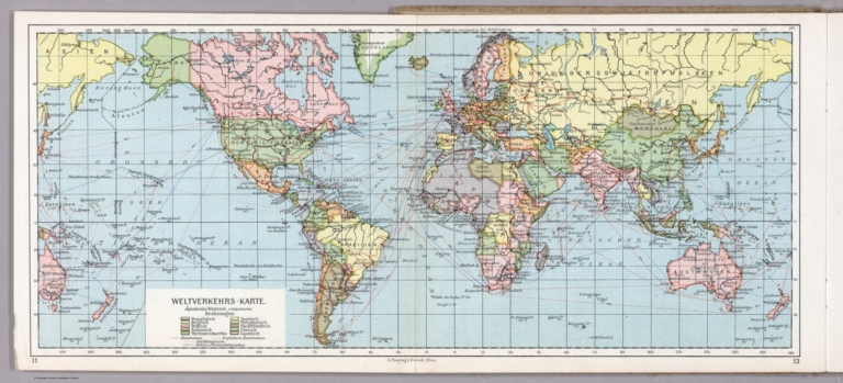
Author
[Hickmann, Anton Leo, 1834-1906, Fischer, Alois, b. 1894]
Full Title
Weltverkehrs - Karte. G. Freytag & Berndt A.G., Wien. (to accompany) Prof. Hickmann's Geographisch-statistischer universal-atlas, 1927.
List No
13687.012
Note
Folded map of the world. Showing transportation routes including shipping lines, railways, overland telegraphs cables and projected railways. Color reference indicating European and United States possessions. Prime meridian: Greenwich.
Author
[Pelet, Paul, 1849-1927, Challamel, Augustin, 1818-1894, Hausermann, R., active 1875-1915]
Full Title
Colonies Françaises. Nouvel atlas des colonies Françaises par Paul Pelet, 1889, No 1. A. Challamel, Éditeur, 5 rue Jacob, Paris. Gravé par R. Hausermann, Paris, Imp. Lemercier et Cie.
List No
14300.011
Note
World map showing French colonies around the world in 1889. Title translates to: French colonies. Features political boundaries, ocean transportation routes, telegraph and cable lines, as well as French consulates. Includes latitudinal and longitudinal lines and a legend. Colored lithograph. Map is 21 x 35 cm, on sheet 26 x 37 cm. Accompanied by descriptive text of the same title, on preceding pages in section I. In first part of atlas.
Author
[Pelet, Paul, 1849-1927, Challamel, Augustin, 1818-1894, Hausermann, R., active 1875-1915]
Full Title
France et Allgérie-Tunisie. Nouvel atlas des colonies Françaises par Paul Pelet, 1891, No 2. A. Challamel, Éditeur, 5 rue Jacob, Paris. Gravé par R. Hausermann, Paris, Imp. Lemercier et Cie.
List No
14300.014
Note
Map of France and Tunisia, including the vicinity. Shows place names, transportation routes, water transportation transportation routes between the two nations via the Mediterranean Sea, cable lines and elevation. Relief shown with shading. Includes latitudinal and longitudinal lines and a legend, as well as a bar scale and a scale statement. With inset map, comparing the distance of the journey - measured in hours - between Paris and Algiers, from 1830 to 1888: Accélération du voyage Paris-Alger, 1830-1888 [= Acceleration of the Paris-Algiers journey 1830-1888]. Colored lithograph. Map is 31 x 25 cm, on sheet 38 x 26 cm. Accompanied by descriptive text of the same title, on preceding pages in section II. In second part of atlas, Afrique.
Author
Anonymous
Full Title
Meridian Highway. U.S. 81 Throughout. The Main Street of North America.
List No
15557.000
Author
Elwe, Jan Barend
Full Title
Poliometria Europae maxime autem Germaniae ac Finitimorum Locorum. Ex offinica Jan Barn. Elwe. Amsteli.
List No
14478.056
Note
Table of travel distances in Europe, especially Germany. Includes descriptive text. Table is 48 x 58 cm, on double sheet 58 x 70 cm.
Author
[IRISH RAILWAY COMMISSION, HARNESS, Henry Drury (1804 - 1883)]
Full Title
IV. Map of Ireland, to accompany the Report of the Railway Commissioners shewing the relative Number of Passengers in different Directions by regular Public Conveyances. Constructed under the Direction of the Commissioners by Henry D. Harness Lt. Royal Engineers 1837.
List No
15443.006
Author
[Greyhound Lines, Groth, John]
Full Title
36,000 Miles of Vacation Highways - Reaching Every Nook and Corner of America - by Luxurious Greyhound Bus Lines.
List No
15440.002
Author
Imhof, Eduard, 1895-1986
Full Title
Politische Gliederung und wichtige Verkehrslinien.
List No
14401.029
Note
Map of Switzerland, featuring the cantons of Switzerland, as well as major transportation routes, in 1969. Also shows topography, bodies of water and drainage. Includes latitudinal and longitudinal lines, and a scale statement. Colored lithograph. Map is 17 x 29 cm, on sheet 22 x 33 cm. Appears in section entitled Schweiz : Thematische Karten [= Switzerland : Thematic Maps].
Author
[Parsons, Brinckerhoff, Hall and Macdonald, San Francisco Bay Area Rapid Transit Commission]
Full Title
(Title Page) Regional Rapid Transit; a Report to the San Francisco Bay Area Rapid Transit Commission, 1953-1955. Parsons, Brinckerhoff, Hall and Macdonald. Engineers. New York.
List No
6344.002
Author
[Parsons, Brinckerhoff, Hall and Macdonald, San Francisco Bay Area Rapid Transit Commission]
Full Title
(Text Page) San Francisco Bay Area Rapid Transit Commission.
List No
6344.003
Author
[Parsons, Brinckerhoff, Hall and Macdonald, San Francisco Bay Area Rapid Transit Commission]
Full Title
Comprehensive Plan for Regional Rapid Transit.
List No
6344.009
Author
[Parsons, Brinckerhoff, Hall and Macdonald, San Francisco Bay Area Rapid Transit Commission]
Full Title
(Text Page) Bay Area Development (con't.) Organization of Urban Activities - 1954
List No
6344.014
Author
[Parsons, Brinckerhoff, Hall and Macdonald, San Francisco Bay Area Rapid Transit Commission]
Full Title
Land Characteristics - 1954.
List No
6344.019
Author
[Parsons, Brinckerhoff, Hall and Macdonald, San Francisco Bay Area Rapid Transit Commission]
Full Title
Land Development Policy. General Zoning Pattern - 1954
List No
6344.021
Author
[Parsons, Brinckerhoff, Hall and Macdonald, San Francisco Bay Area Rapid Transit Commission]
Full Title
Organization of Urban Activities - 1990
List No
6344.023
Author
[Parsons, Brinckerhoff, Hall and Macdonald, San Francisco Bay Area Rapid Transit Commission]
Full Title
Generalized Automobile Traffic Flow - 1954.
List No
6344.025
Author
[Parsons, Brinckerhoff, Hall and Macdonald, San Francisco Bay Area Rapid Transit Commission]
Full Title
Interurban Transit Traffic Flow. Generalized Transit Traffic Flow - 1954.
List No
6344.026
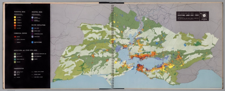
Author
[Parsons, Brinckerhoff, Hall and Macdonald, San Francisco Bay Area Rapid Transit Commission]
Full Title
Existing Land Use - 1954.
List No
6344.028
Note
Full color.
|


![[Map of Russia].](https://www.davidrumsey.com/rumsey/Size2/RUMSEY~8~1/205/14402009.jpg)