|
Author
Survey of India Department
Full Title
Physical configuration. Reg. No. 873, R. & A. Dept. - June 94 - 2,016. Litho. SIO. Calcutta.
List No
14252.007
Note
Lithographed topographic map of India, illustrating elevation in feet with, color coding. Map shows mountain ranges, rivers, bays, seas and islands. Includes a legend and explanatory note, as well as latitudinal and longitudinal lines, a bar scale and scale statement: Scale 1 inch = 192 miles. With inset map: England and Scotland on the same scale. 26 x 31 cm, on sheet 34 x 43 cm.
Author
Astrogeology Science Center (Geological Survey)
Full Title
Hadley Rille : EVA - I. Contour interval 10 Meters. July 19971. Hadley-Apennine Landing Site Apollo 15. U.S.G.S, Center for Astrogeology.
List No
13549.003
Note
Topographic map of EVA - I. Relief shown by contours and spot heights.
Author
Astrogeology Science Center (Geological Survey)
Full Title
Hadley Rille : EVA - II. Contour interval 10 Meters. July 19971. Hadley-Apennine Landing Site Apollo 15. U.S.G.S, Center for Astrogeology.
List No
13549.005
Note
Topographic map of f EVA - II. Relief shown by contours and spot heights.
Author
Astrogeology Science Center (Geological Survey)
Full Title
Hadley Rille : EVA - III. Contour interval 10 Meters. July 19971. Hadley-Apennine Landing Site Apollo 15. U.S.G.S, Center for Astrogeology.
List No
13549.007
Note
Topographic map of f EVA - III. Relief shown by contours and spot heights.
Author
Astrogeology Science Center (Geological Survey)
Full Title
Hadley Rille : Walking transverses : EVA - I, II, III. Contour interval 10 Meters. July 19971. Hadley-Apennine Landing Site Apollo 15. U.S.G.S, Center for Astrogeology.
List No
13549.021
Note
Topographic map of EVA - I, II, III. Relief shown by contours and spot heights.
Author
[Iran Oil Exploration and Production Joint Stock Company, Aero Service Corporation]
Full Title
ایران (Iran) شرکتهای عامل نفت ایران (Iranian Oil Companies) شرکت سهامی اکتشاف و تولید نفت ایران، شرکت سهامی تصفیه نفت ایران) با همکاری شرکت ملی نفت ایران و سازمان نقشه برداری کل (Iran Oil Exploration and Production Joint Stock Company, Iran Oil Refining Joint Stock Company in cooperation with the National Iranian Oil Company and the Mapping Organization of the whole country)
List No
15736.000
Note
3D Plastic relief map. Date estimated.
Author
Aero Service Corporation
Full Title
The Aero Relief Map Of Africa. True Raised Relief Maps.
List No
15737.000
Note
3D plastic relief map.
Author
Aero Service Corporation
Full Title
The Aero Relief Map Of Europe. Published by Aero Service Corporation Photogrammetric Engineers Relief Model Division.
List No
15735.000
Note
3D plastic relief map.
Author
Aero Service Corporation
Full Title
(Greece, Turkey)
List No
15738.000
Note
3D plastic relief map.
Author
Aero Service Corporation
Full Title
The Aero Relief Map Of Canada. Published by Aero Service Corporation Photogrammetric Engineers Relief Model Division.
List No
15739.000
Note
3D plastic relief map.
Author
Aero Service Corporation
Full Title
South America. Published by Aero Service Corporation Photogrammetric Engineers Relief Model Division.
List No
15740.000
Note
3D plastic relief map.
Author
[Sydow, Emil von., 1812-1873, Wagner, Hermann, 1840-1929]
Full Title
Gelandezeichnung. Gezeichn. v. V. Geyer. Gelande gest. v. A. Kramer. Entw. v. H. Wagner. Gotha : Justus Perthes. Sydow-Wagners method. Schul-Atlas XXIII.
List No
13559.019
Note
Maps and diagrams of landscape characterization in variable scales, showing topographic Terrain drawings.
Author
[Sydow, Emil von., 1812-1873, Wagner, Hermann, 1840-1929]
Full Title
Gelandezeichnung. Gezeichn. v. V. Geyer. Gelande gest. v. A. Kramer. Entw. v. H. Wagner. Gotha : Justus Perthes. Sydow-Wagners method. Schul-Atlas. XXI.
List No
13557.020
Note
Maps and diagrams of landscape characterization in variable scales, showing topographic Terrain drawings. Designed by H. Wagner. Drawn. by V. Geyer. Terrain by A. Kramer.
Author
[Ravenstein, August, Berlin Geographisch-Artistische Anstalt Ernst Schotte]
Full Title
Karten-Ideal zur elementaren Darstellung der topischen Verhältnisse von Wasser und Land auf dem Erdboden, nebst der Oestl. & Westl. Erdhälfte, zur Erläuterung mathemat. eintheilung u. physisch-geograph. Verhältnisse. Zeichnung u. Modell von August Ravenstein in Frankfurt a. M. Stich, Prägung, Druck u. Verlag von B. Dondorf in Frankfurt a. M.
List No
14473.003
Note
Relief map of the world, shown as the Western and Eastern Hemispheres, as well as a closer view of the Netherlands and vicinity. Shows geographical regions, topography, vegetation, bodies of water, drainage, coastlines, shoals and islands. Topography shown with raised relief. Includes latitudinal and longitudinal lines, as well as descriptive notes. Legend for map appears on title page. Colored lithograph. Map is 22 x 27 cm, within frame 24 x 28 cm. Within a series of eight maps comprising the school atlas, Plastischer Schul-Atlas.
Author
[Ravenstein, August, Berlin Geographisch-Artistische Anstalt Ernst Schotte]
Full Title
Deutschland nebst den Königreichen Holland, Belgien und der Republik Schweiz. Zeichnung u. Modell von August Ravenstein in Frankfurt a. M. Stich, Prägung, Druck u. Verlag von B. Dondorf in Frankfurt a. M.
List No
14473.004
Note
Relief map of Germany, the Netherlands, Belgium and Switzerland. Shows geographical regions, countries, cities, railways, canals, topography, vegetation, bodies of water, drainage, coastlines, shoals and islands. Topography shown with raised relief. Includes a legend, bar scale given in miles, latitudinal and longitudinal lines, as well as statistical and descriptive notes. Additional legend for map appears on title page. Colored lithograph. Map is 22 x 27 cm, within frame 24 x 28 cm. Within a series of eight maps comprising the school atlas, Plastischer Schul-Atlas.
Author
[Ravenstein, August, Berlin Geographisch-Artistische Anstalt Ernst Schotte]
Full Title
Europa. Zeichnung u. Modell von August Ravenstein in Frankfurt a. M. Stich, Prägung, Druck u. Verlag von B. Dondorf in Frankfurt a. M.
List No
14473.005
Note
Relief map of Europe. Shows geographical regions, countries, cities, railways, topography, vegetation, bodies of water, drainage, coastlines, shoals and islands. Topography shown with raised relief. Includes a legend, bar scale given in miles, latitudinal and longitudinal lines, as well as statistical and descriptive notes. Additional legend for map appears on title page. With a vignette of scenery, figures, fauna and flora. Colored lithograph. Map is 22 x 27 cm, within frame 24 x 28 cm. Within a series of eight maps comprising the school atlas, Plastischer Schul-Atlas.
Author
[Ravenstein, August, Berlin Geographisch-Artistische Anstalt Ernst Schotte]
Full Title
Asien. Zeichnung u. Modell von August Ravenstein in Frankfurt a. M. Stich, Prägung, Druck u. Verlag von B. Dondorf in Frankfurt a. M.
List No
14473.006
Note
Relief map of Asia. Shows geographical regions, countries, cities, railways, topography, vegetation, bodies of water, drainage, coastlines, shoals and islands. Topography shown with raised relief. Includes a legend, bar scale given in miles, latitudinal and longitudinal lines, as well as statistical and descriptive notes. Additional legend for map appears on title page. With an indexed vignette of scenery, indigenous figures, fauna and flora. Colored lithograph. Map is 22 x 27 cm, within frame 24 x 28 cm. Within a series of eight maps comprising the school atlas, Plastischer Schul-Atlas.
Author
[Ravenstein, August, Berlin Geographisch-Artistische Anstalt Ernst Schotte]
Full Title
Nord-u. Mittel-Amerika. Zeichnung u. Modell von August Ravenstein in Frankfurt a. M. Stich, Prägung, Druck u. Verlag von B. Dondorf in Frankfurt a. M.
List No
14473.007
Note
Relief map of North and Central America. Shows geographical regions, countries, cities, railways, topography, vegetation, bodies of water, drainage, coastlines, shoals and islands. Topography shown with raised relief. Includes a legend, bar scale given in miles, latitudinal and longitudinal lines, as well as statistical and descriptive notes. Additional legend for map appears on title page. With an indexed vignette of scenery, figures, fauna and flora. Colored lithograph. Map is 27 x 22 cm, within frame 28 x 24 cm. Within a series of eight maps comprising the school atlas, Plastischer Schul-Atlas.
Author
[Ravenstein, August, Berlin Geographisch-Artistische Anstalt Ernst Schotte]
Full Title
Südamerika. Zeichnung u. Modell von August Ravenstein in Frankfurt a. M. Stich, Prägung, Druck u. Verlag von B. Dondorf in Frankfurt a. M.
List No
14473.008
Note
Relief map of South America. Shows geographical regions, countries, cities, railways, topography, vegetation, bodies of water, drainage, coastlines, shoals and islands. Topography shown with raised relief. Includes a legend, bar scale given in miles, latitudinal and longitudinal lines, as well as statistical and descriptive notes. Additional legend for map appears on title page. With an indexed vignette of scenery, figures, fauna and flora. Colored lithograph. Map is 27 x 22 cm, within frame 28 x 24 cm. Within a series of eight maps comprising the school atlas, Plastischer Schul-Atlas.
Author
[Ravenstein, August, Berlin Geographisch-Artistische Anstalt Ernst Schotte]
Full Title
Afrika. Zeichnung u. Modell von August Ravenstein in Frankfurt a. M. Stich, Prägung, Druck u. Verlag von B. Dondorf in Frankfurt a. M.
List No
14473.009
Note
Relief map of Africa. Shows geographical regions, countries, cities, railways, topography, vegetation, bodies of water, drainage, coastlines, shoals and islands. Topography shown with raised relief. Includes a legend, bar scale given in miles, latitudinal and longitudinal lines, as well as statistical and descriptive notes. Additional legend for map appears on title page. With an indexed vignette of scenery, figures, fauna and flora. Colored lithograph. Map is 22 x 27 cm, within frame 24 x 28 cm. Within a series of eight maps comprising the school atlas, Plastischer Schul-Atlas.
Author
[Ravenstein, August, Berlin Geographisch-Artistische Anstalt Ernst Schotte]
Full Title
Australien und Polynesien. Zeichnung u. Modell von August Ravenstein in Frankfurt a. M. Stich, Prägung, Druck u. Verlag von B. Dondorf in Frankfurt a. M.
List No
14473.010
Note
Relief map of Australia and Polynesia. Shows geographical regions, countries, cities, railways, topography, vegetation, bodies of water, drainage, coastlines, shoals and islands. Topography shown with raised relief. Includes a legend, bar scale given in miles, latitudinal and longitudinal lines, as well as statistical and descriptive notes. Additional legend for map appears on title page. With an indexed vignette of scenery, figures, fauna and flora. Colored lithograph. Map is 22 x 27 cm, within frame 24 x 28 cm. Within a series of eight maps comprising the school atlas, Plastischer Schul-Atlas.
Author
Desjardins, Constant
Full Title
Esquisse des eaux et des montagnes de l'Europe par Ct. Desjardins. Paris. 1843.
List No
14393.005
Note
Hydrographic and topographic map of Europe. Features topography, bodies of water, drainage and coastlines. Relief shown with shading. Includes latitudinal and longitudinal lines. Colored lithograph. Map is 32 x 45 cm, on double sheet 41 x 54 cm.
Author
Desjardins, Constant
Full Title
Carte orographique ou tableau des systèmes, chaines de montagnes ou dos de pays, caps et iles de l'Europe par Ct. Desjardins. Paris, Lithochromie géographique del’Auteur, rue Cadet 5.
List No
14393.006
Note
Orographic map of Europe. Features mountain ranges. Also shows political boundaries, cities, bodies of water, drainage and coastlines. Relief shown with shading. Includes latitudinal and longitudinal lines, as well as explanatory text. With profile view of mountain ranges, which provides elevation. Colored lithograph. Map is 34 x 44 cm, on double sheet 41 x 54 cm. (Date inferred.)
Author
Washburn, Bradford
Full Title
MOUNT WASHINGTON and the heart of THE PRESIDENTIAL RANGE, New Hampshire.
List No
15453.002
Author
[FESCA, Max (1846-1917), HARADA, Toyokichi (1860 - 1894), 農商務省地質局 / NŌSHŌMUSHŌ CHISHITSUKYOKU / GEOLOGICAL BUREAU, MINISTRY OF AGRICULTURE AND COMMERCE]]
Full Title
I. Systems of Mountains and Rivers.
List No
15441.003
Author
Vallardi, Francesco
Full Title
(Composite Map to) Carta orografica ed idrografica dell'Italia Settentrionale (Valle del Pó, Tre Fogli). Casa Edit. Dott. Francesco Vallardi.
List No
14396.019
Note
Composite of three-sheet topographic and hydrographic map of Northern Italy. Features cities, topography, bodies of water, drainage and coastline. Relief shown with hachures. Includes latitudinal and longitudinal lines, as well as a bar scale and scale statement. Colored engraving. Map is 59 x 129 cm, on three double sheets, together 84 x 180 cm. Sheets appear consecutively. (Title taken from Indice [Index].) Followed by second and third sheets. Within section entitled Italia Settentrionale.
Author
Vallardi, Francesco
Full Title
(Composite Map to) Carta dell'Italia, in quindici fogli, ricavata dalle migliori mappe finora publicate nella proporzione di 1. a 600,000. Milano, dalla Casa Editrice Dr. Francesco Vallardi. G. Pozzi scrisse.
List No
14396.097
Note
Composite of 15-sheet topographic map of Italy. Features political boundaries, cities, railways, roads, topography, bodies of water, drainage, coastlines and islands. Relief shown with hachures. Includes latitudinal and longitudinal lines. Title, imprint, two bar scales and a scale statement appear on third sheet. Inset map on thirteenth sheet: Europa. Decorative border. Colored engraving. Map is is 225 x 180 cm, on fifteen double sheets, together 300 x 252 cm. Sheets appear consecutively. Within section entitled Gran Carta topografica dell'Italia in quincici fogli nella proporzione di 1 a 600,000.
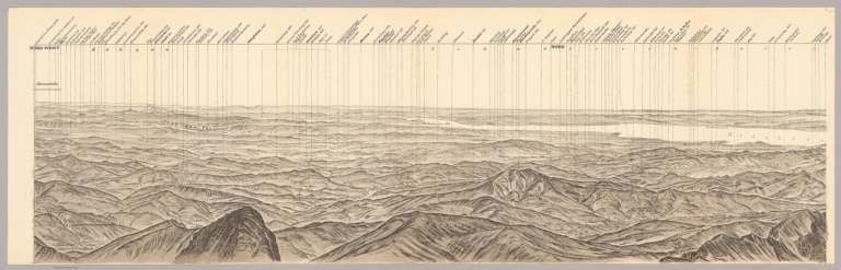
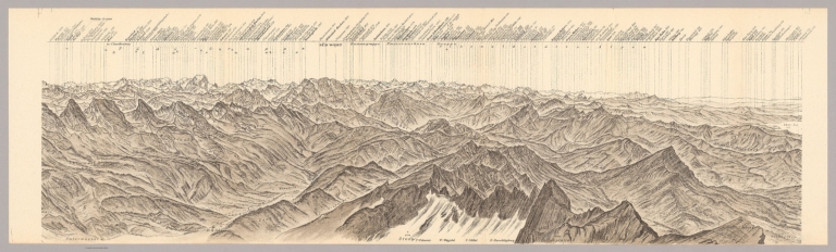
Author
[Heim, Albert, Imhof, Eduard, 1895-1986]
Full Title
BL I Rundsicht vom Gipfel des Santis. VIII Auflage. Revision und Reliefton von Prof. Ed. Imhof.
List No
15397.002
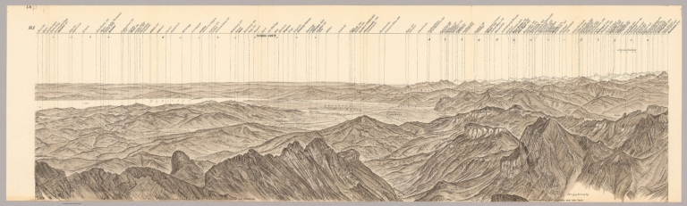
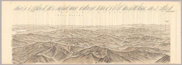
Author
[Heim, Albert, Imhof, Eduard, 1895-1986]
Full Title
BL II Rundsicht vom Gipfel des Santis. VIII Auflage. Revision und Reliefton von Prof. Ed. Imhof.
List No
15397.003
Author
[Heim, Albert, Imhof, Eduard, 1895-1986]
Full Title
BL III Rundsicht vom Gipfel des Santis. VIII Auflage. Revision und Reliefton von Prof. Ed. Imhof.
List No
15397.004
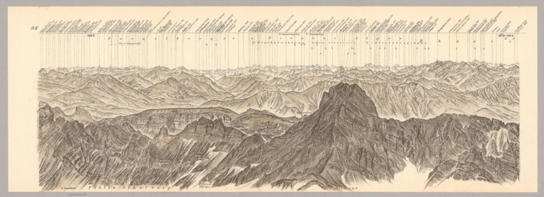
Author
[Heim, Albert, Imhof, Eduard, 1895-1986]
Full Title
BL IV Rundsicht vom Gipfel des Santis. VIII Auflage. Revision und Reliefton von Prof. Ed. Imhof.
List No
15397.005
Author
[Heim, Albert, Imhof, Eduard, 1895-1986]
Full Title
BL V Rundsicht vom Gipfel des Santis. VIII Auflage. Revision und Reliefton von Prof. Ed. Imhof.
List No
15397.006
Author
[Heim, Albert, Imhof, Eduard, 1895-1986]
Full Title
BL VI Rundsicht vom Gipfel des Santis. VIII Auflage. Revision und Reliefton von Prof. Ed. Imhof.
List No
15397.007
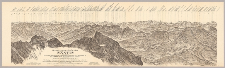
Author
[Heim, Albert, Imhof, Eduard, 1895-1986]
Full Title
(Composite view to) BL I - VI Rundsicht vom Gipfel des Santis. VIII Auflage. Revision und Reliefton von Prof. Ed. Imhof.
List No
15397.008
Author
[Imhof, Eduard, 1895-1986, Leuzinger, Heinz]
Full Title
Graubünden (SW) and Ticino
List No
15373.001
Note
Date estimated. Image downloaded from https://www.shadedreliefarchive.com/
Author
[Imhof, Eduard, 1895-1986, Leuzinger, Heinz]
Full Title
Graubünden (NW)
List No
15373.002
Note
Date estimated. Image downloaded from https://www.shadedreliefarchive.com/
Author
[Imhof, Eduard, 1895-1986, Leuzinger, Heinz, Spiess, Ernst, Speiser, Bruno]
Full Title
Schaffhausen, Switzerland
List No
15374.000
Note
Date estimated. Image downloaded from https://www.shadedreliefarchive.com/
Author
Imhof, Eduard, 1895-1986
Full Title
Northeast Switzerland - South Sheet
List No
15375.001
Note
Date estimated. Image downloaded from https://www.shadedreliefarchive.com/
Author
Imhof, Eduard, 1895-1986
Full Title
Northeast Switzerland - North Sheet
List No
15375.002
Note
Date estimated. Image downloaded from https://www.shadedreliefarchive.com/
Author
[Imhof, Eduard, 1895-1986, Ficker, Kurt]
Full Title
Zurich, Switzerland
List No
15376.000
Note
Date estimated. Image downloaded from https://www.shadedreliefarchive.com/
Author
Imhof, Eduard, 1895-1986
Full Title
Zentralschweiz.
List No
14401.008
Note
Map of central Switzerland, in 1969. Shows cities, railways, roads, topography, valleys, glaciers, bodies of water and drainage. Relief shown with contour lines, shading and spot heights. Includes a bar scale and scale statement. Colored lithograph. Map is 24 x 17 cm, on sheet 33 x 22 cm. Appears in section entitled Schweiz : Einzelne Landschaften [= Individual landscapes].
Author
Imhof, Eduard, 1895-1986
Full Title
Gruyères (Kt. Freiburg) -- Mürtschenstock (Kt. Glarus) : Bergformen im Kalkfels, Karrenfelder.
List No
14401.009
Note
Two maps of Switzerland, featuring the city of Gruyères in the canton of Fribourg, and Mürtschenstock, a mountain massif of the Glarus [Glarner] Alps, in the canton of Glarus, in 1969. Maps also show cities, railways, roads, topography, valleys, glaciers, bodies of water and drainage. Relief shown with contour lines, shading and spot heights. Maps include bar scales (scales differ) and scale statements. Colored lithograph. Together, maps are 29 x 17 cm, on sheet 33 x 22 cm. Maps appear in section entitled Schweiz : Einzelne Landschaften [= Individual landscapes].
Author
Imhof, Eduard, 1895-1986
Full Title
Matterhorn und Z'Muttgletscher : Kristalline Bergformen -- Rhonetal bei Sierre und Leuk : Talstufe und Sprachgrenze zwischen Ober- und Unterwallis.
List No
14401.010
Note
Two maps of Switzerland, featuring the Matterhorn mountain, the Muttgletscher glacier and the Rhône River Valley, near the cities of Sierre and Leuk, in 1969. Maps also show cities, railways, roads, topography, valleys, glaciers, bodies of water and drainage. Relief shown with contour lines, shading and spot heights. Maps include bar scales (scales differ) and scale statements. Colored lithograph. Together, maps are 29 x 17 cm, on sheet 33 x 22 cm. Maps appear in section entitled Schweiz : Einzelne Landschaften [= Individual landscapes].
Author
Imhof, Eduard, 1895-1986
Full Title
Gotthardgebiet -- Luganersee.
List No
14401.011
Note
Two maps of Switzerland, featuring the Gotthard Pass and Lake Lugano, in 1969. Maps also show cities, railways, roads, topography, valleys, glaciers, bodies of water and drainage. Relief shown with contour lines, shading and spot heights. Maps include bar scales (scales differ) and scale statements. Colored lithograph. Together, maps are 29 x 17 cm, on sheet 33 x 22 cm. Maps appear in section entitled Schweiz : Einzelne Landschaften [= Individual landscapes].
Author
Imhof, Eduard, 1895-1986
Full Title
Säntisgruppe und Appenzellerland : (Nördlicher Alpenrand).
List No
14401.012
Note
Map of Switzerland, featuring the mountain of Säntis and the Appenzell Alps, on the northern edge of the Swiss Alps, in 1969. Also shows cities, railways, roads, topography, valleys, glaciers, bodies of water and drainage. Relief shown with contour lines, shading and spot heights. Includes a bar scale and scale statement. Colored lithograph. Map is 29 x 17 cm, on sheet 33 x 22 cm. Appears in section entitled Schweiz : Einzelne Landschaften [= Individual landscapes].
Author
Imhof, Eduard, 1895-1986
Full Title
Jungfraugruppe und Aletschgletscher.
List No
14401.013
Note
Map of Switzerland, featuring the mountain of Jungfrau and the Aletsch Glacier, in 1969. Also shows cities, railways, roads, topography, valleys, glaciers, bodies of water and drainage. Relief shown with contour lines, shading and spot heights. Includes a bar scale and scale statement. Colored lithograph. Map is 29 x 17 cm, on sheet 33 x 22 cm. Appears in section entitled Schweiz : Einzelne Landschaften [= Individual landscapes].
Author
Imhof, Eduard, 1895-1986
Full Title
Oberengadin.
List No
14401.014
Note
Map of Switzerland, featuring the valley of Engadine, in 1969. Shows cities, railways, roads, topography, valleys, glaciers, bodies of water and drainage. Relief shown with contour lines, shading and spot heights. Includes a bar scale and scale statement. Colored lithograph. Map is 17 x 29 cm, on sheet 22 x 33 cm. Appears in section entitled Schweiz : Einzelne Landschaften [= Individual landscapes].
Author
Imhof, Eduard, 1895-1986
Full Title
Napfgruppe -- Waadtländer Faltenjura.
List No
14401.015
Note
Two maps of Switzerland, featuring the mountain of Napf and part of the "folded" Jura Mountains, in 1969. Maps also show cities, railways, roads, topography, valleys, glaciers, bodies of water and drainage. Relief shown with contour lines, shading and spot heights. Maps include bar scales and scale statements. Colored lithograph. Together, maps are 29 x 17 cm, on sheet 33 x 22 cm. Maps appear in section entitled Schweiz : Einzelne Landschaften [= Individual landscapes].
Author
Imhof, Eduard, 1895-1986
Full Title
Berner Faltenjura -- Basler und Aargauer Jura : Übergang vom Tafeljura zum Faltenjura.
List No
14401.016
Note
Two maps of Switzerland, featuring parts of the "folded" Jura Mountains, in 1969. Maps also show cities, railways, roads, topography, valleys, glaciers, bodies of water and drainage. Relief shown with contour lines, shading and spot heights. Maps include bar scales and scale statements. Colored lithograph. Together, maps are 29 x 17 cm, on sheet 33 x 22 cm. Maps appear in section entitled Schweiz : Einzelne Landschaften [= Individual landscapes].
Author
Imhof, Eduard, 1895-1986
Full Title
Glaziallandschaft im Stammheimertal : Das Gebiet der Seen vor der Melioration -- Glaziallandschaft im Glattal : vor der Melioration, Drumlins.
List No
14401.017
Note
Two maps of Switzerland, featuring glacial landscapes in the Stammheimertal area and the Glatt Valley, in 1969. Maps also show cities, railways, roads, topography, valleys, glaciers, bodies of water and drainage. Relief shown with contour lines, shading and spot heights. Maps include bar scales and scale statements. Colored lithograph. Together, maps are 29 x 17 cm, on sheet 33 x 22 cm. Maps appear in section entitled Schweiz : Einzelne Landschaften [= Individual landscapes].
|