|
REFINE
Browse All : Title Page from 1940
1-30 of 30
Author
[Sydow, Emil von., 1812-1873, Wagner, Hermann, 1840-1929]
Full Title
(Title Page to) Sydow-Wagners methodischer Schul-Atlas : 21 Auflage. Bearbeitet von H. Haack und H. Lautensach. 67 haupt - und 232 nebenkarten auf 64 tafeln mit einem namenverzeichnis. Berichtigter Neudruck 1940. Justus Perthes in Gotha.
List No
13557.002
Author
[Budapest (Hungary). Föváros Statisztikai Hivatal, Illyefalvi, Lajos I., 1881-1944]
Full Title
(Title Page to) Dr. Illyefalvi I. Lajos. A székesföváros jelentösége hazánk anyagi és szellemi müvelödésében. = Dr. Ludwig I. Illyefalvi. Die Bedeutung der Hauptstadt Budapest im Wirtschaftlichen und Geistigen Leben Ungarns.
List No
14247.002
Note
Title page to Budapest székesföváros áruforgalma. Includes German translation of the Hungarian. Verso has text: Felelös szerkesztö: Dr. Illyefalvi Il. Lajos ; Budapest székesföváros házinyomdája 1940 - 1937/8560 ; Felelös nyomdavezetö: Kurfürst István vezérigazgató.
Author
Federal Works Agency, Work Projects Administration
Full Title
(Title to) San Francisco Scale Model, Scale 1 inch 100 ft. Constructed by Federal Works Agency, Work Projects Administration. Sponsored by City Planning Commission. 1940.
List No
10261.002
Note
Title to the San Francisco Model in the form of a plaque.
Author
[State Farm Insurance Companies Travel Bureau, Rand McNally and Company]
Full Title
(Title Page to) State Farm Road Atlas: United States, Canada, Mexico,Central and South America. Copyright 1940 by Rand McNally & Company, Chicago, Ill. (opposite title page) The State Farm Insurance Companies Home Office: Bloomington, Illinois ; Pacific Coast Office: Berkeley, California. Cost to Cost Service ...
List No
5969.002
Note
This 1940 State Farm Road Atlas was designed by and published exclusively for distribution by the Travel Bureau of the State Farm Insurance Companies ... Atlas is bound in beige card board 40x30 1/2 printed with title "State farm road atlas: United States, Canada, Mexico, South America, Central America." 124 p. including 89 maps. Most maps printed in full color. Also on back cover: Advertisement for the State Farm Insurance Companies and view of Home office building, Bloomington, Ill.
Author
Oberkommando der Wehrmacht (OKW) (Nazi German Supreme Command of the Armed Forces)
Full Title
(Title Page) Objektbilder zu den Militargeographischen Objektkarten (Images of the Military-Geographic Objectives) 1:250,000 und 1:10,000 der Mappe 1, The Border. Abgeschlossen am (Completed on) 15 Mai 1942... Berlin 1942.
List No
7807.012
Author
Oberkommando der Wehrmacht (OKW) (Nazi German Supreme Command of the Armed Forces)
Full Title
(Title Page) Objektbilder zu den Militargeographischen Objektkarten (Images of the Military-Geographic Objectives) 1:250,000 und 1:10,000 der Mappe 2, Nordliches Zentralgebeit. Abgeschlossen am (Completed on) 15 Mai 1942... Berlin 1942.
List No
7807.072
Author
Oberkommando der Wehrmacht (OKW) (Nazi German Supreme Command of the Armed Forces)
Full Title
(Title Page) Objektbilder zu den Militargeographischen Objektkarten (Images of the Military-Geographic Objectives) 1:250,000 und 1:10,000 der Mappe 3, Nordost-England. Abgeschlossen am (Completed on) 30 April 1942... Berlin 1942.
List No
7807.128
Author
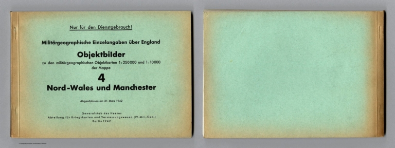
Oberkommando der Wehrmacht (OKW) (Nazi German Supreme Command of the Armed Forces)
Full Title
(Covers to) Objektbilder zu den Militargeographischen Objektkarten (Images of the Military-Geographic Objectives) 1:250,000 und 1:10,000 der Mappe 4, Nord-Wales und Manchester. Abgeschlossen am (Completed on) 31 Marz 1942... Berlin 1942.
List No
7807.207
Author
Oberkommando der Wehrmacht (OKW) (Nazi German Supreme Command of the Armed Forces)
Full Title
(Title Page) Objektbilder zu den Militargeographischen Objektkarten (Images of the Military-Geographic Objectives) 1:250,000 und 1:10,000 der Mappe 4, Nord-Wales und Manchester. Abgeschlossen am (Completed on) 31 Marz 1942... Berlin 1942.
List No
7807.208
Author
Oberkommando der Wehrmacht (OKW) (Nazi German Supreme Command of the Armed Forces)
Full Title
(Title Page) Objektbilder zu den Militargeographischen Objektkarten (Images of the Military-Geographic Objectives) 1:250,000 und 1:10,000 der Mappe 6, Nord-Midlands. Abgeschlossen am (Completed on) 12 Marz 1942... Berlin 1942.
List No
7807.322
Author
Oberkommando der Wehrmacht (OKW) (Nazi German Supreme Command of the Armed Forces)
Full Title
(Title Page) Objektbilder zu den Militargeographischen Objektkarten (Images of the Military-Geographic Objectives) 1:250,000 und 1:10,000 der Mappe 7, Sudwales. Abgeschlossen am (Completed on) 30 November 1941... Berlin 1941.
List No
7807.400
Author
Oberkommando der Wehrmacht (OKW) (Nazi German Supreme Command of the Armed Forces)
Full Title
(Title Page) Objektbilder zu den Militargeographischen Objektkarten (Images of the Military-Geographic Objectives) 1:250,000 und 1:10,000 der Mappe 8, Midlands. Abgeschlossen am (Completed on) 7, Oktober 1941 ... Berlin 1941.
List No
7807.471
Author
Oberkommando der Wehrmacht (OKW) (Nazi German Supreme Command of the Armed Forces)
Full Title
(Title Page) Objektbilder zu den Militargeographischen Objektkarten (Images of the Military-Geographic Objectives) 1:250,000 und 1:10,000 der Mappe 9, Ost-Anglia. Abgeschlossen am (Completed on) 30, September 1941... Berlin 1941.
List No
7807.512
Author
Oberkommando der Wehrmacht (OKW) (Nazi German Supreme Command of the Armed Forces)
Full Title
(Title Page) Objektbilder zu den Militargeographischen Objektkarten (Images of the Military-Geographic Objectives) 1:250,000 und 1:10,000 der Mappe 10, Sudwest-England. Abgeschlossen am (Completed on) 18 September 1941... Berlin 1941.
List No
7807.550
Note
Contents as of 18 September, 1941.
Author
Oberkommando der Wehrmacht (OKW) (Nazi German Supreme Command of the Armed Forces)
Full Title
(Title Page) Objektbilder zu den Militargeographischen Objektkarten (Images of the Military-Geographic Objectives) 1:250,000 und 1:10,000 der Mappe 11, Sud-England. Abgeschlossen am (Completed on) 5 Oktober 1941 ... Berlin 1941.
List No
7807.584
Author
Oberkommando der Wehrmacht (OKW) (Nazi German Supreme Command of the Armed Forces)
Full Title
(Title Page) Objektbilder zu den Militargeographischen Objektkarten (Images of the Military-Geographic Objectives) 1:250,000 und 1:10,000 der Mappe 12, Sudost-England und London. Abgeschlossen am (Completed on) 2 Oktober 1941... Berlin 1941.
List No
7807.629
Author
Oberkommando der Wehrmacht (OKW) (Nazi German Supreme Command of the Armed Forces)
Full Title
(Title Page) Mappe A. (Folder A). Nur fur den Dienstgebrauch! (Only for internal use!) Militargeographische Angaben uber England. (Military - Geographic Information about England). (London siehe auch Mappe B (London See Folder B)). Textheft. 3. Auflage (3rd Edition). Abgeschlossen am 31. August 1941. (Completed on 31 August 1941). Generalstab des Heeres. Abteilung fur Kriegskarten und Vermessungswesen (General Staff of the Army. Department for War Maps and Surveying).(IV. Mil.-Geo Berlin 1941. (Index Page) Anderungen zur 1. bzw. 2. Auflage sind in Klammern vermerkt. (Changes to the 1st or 2nd edition are noted in parentheses).
List No
7808.003
Note
Completed on 31 August 1941.
Author
Oberkommando der Wehrmacht (OKW) (Nazi German Supreme Command of the Armed Forces)
Full Title
(Title Page to) Mappe A. (Folder A). Nur fur den Dienstgebrauch! (Only for internal use!) Militargeographische Angaben uber England. (Military - Geographic Information about England). (London siehe auch Mappe B (London See Folder B)). Ortschaftsverzeichnis (Town Directory). 3. Auflage (3rd Edition). Abgeschlossen am 31. August 1941. (Completed on 31 August 1941). Generalstab des Heeres. Abteilung fur Kriegskarten und Vermessungswesen (General Staff of the Army. Department for War Maps and Surveying).(IV. Mil.-Geo Berlin 1941. (Index Page) Anderungen zur 1. bzw. 2. Auflage sind in Klammern vermerkt. (Changes to the 1st or 2nd edition are noted in parentheses).
List No
7808.071
Note
Completed on 31 August 1941. Each place is described and given a map reference.
Author
Oberkommando der Wehrmacht (OKW) (Nazi German Supreme Command of the Armed Forces)
Full Title
(Covers to and Title Page for) Mappe A. (Folder A). Nur fur den Dienstgebrauch! (Only for internal use!) Militargeographische Angaben uber England. (Military - Geographic Information about England). Bildheft, England insgesamt (Picture Book, England). (London siehe Sonderheft in Mappe B (London See Special Issue in Folder B)). 3. Auflage (3rd Edition). Abgeschlossen am 31. August 1941. (Completed on 31 August 1941). Generalstab des Heeres. Abteilung fur Kriegskarten und Vermessungswesen (General Staff of the Army. Department for War Maps and Surveying).(IV. Mil.-Geo Berlin 1941. (Index Page) Anderungen zur 1. bzw. 2. Auflage sind in Klammern vermerkt. (Changes to the 1st or 2nd edition are noted in parentheses).
List No
7808.075
Author
Oberkommando der Wehrmacht (OKW) (Nazi German Supreme Command of the Armed Forces)
Full Title
(Title Page) Stationsverzeichnis zur Karte Grossbritannien und Irland. (Index of Railway Stations on Map of Great Britain and Ireland). 1:1,000,000. Abgeschlossen am 1. August 1940. (Completed on August 1, 1940). Nur fur den Dienstgebrauch! (Only for Internal Use!). Generalstab des Heeres. Abteilung fur Kriegskarten und Vermessungswesen (General Staff of the Army. Department for War Maps and Surveying). (IV. Mil.-Geo.) Berlin 1941.
List No
7808.259
Author
Oberkommando der Wehrmacht (OKW) (Nazi German Supreme Command of the Armed Forces)
Full Title
(Title Page) Stadtdurchfahrtplane England (ohne) London. (City Transit Plan England (without) London). 2. verbesserte Auflage. (2nd Improved Edition). Abgeschlossen am 1.August 1941. Completed on August 1, 1941). Anlage zu Mil.-Geo.-Angaben uber England (Mappe A). (Appendix to Mil-Geo.-information about England (Folder A)). Generalstab des Heeres. Abteilung fur Kriegskarten und Vermessungswesen (IV. Mil.-Geo.) Berlin 1941. (General Staff of the Army. Department for War Maps and Surveying (IV Mil.-Geo.) Berlin 1941).
List No
7808.271
Note
Paperback with pale green paper covers with black text of title as above.
Author
Oberkommando der Wehrmacht (OKW) (Nazi German Supreme Command of the Armed Forces)
Full Title
(Title Page) Nur fur den Dienstgebrauch! (Only for internal use!) Militargeographische Angaben uber England. (Military - Geographic Information about England). London. Text- und Bildheft. 2. Auflage. (2nd Edition). Abgesschlossen am 31. August 1941. Generalstab des Heeres. Abteilung fur Kriegskarten und Vermessungswesen (General Staff of the Army. Department for War Maps and Surveying).(IV. Mil.-Geo Berlin 1941. (Index Page) Inhalt. (Contents).
List No
7809.003
Note
Completed on 31 August 1941. Collection includes a less detailed version dated 1 September, 1940 that was not scanned.
Author
Oberkommando der Wehrmacht (OKW) (Nazi German Supreme Command of the Armed Forces)
Full Title
(Title Page) Nur fur den Dienstgebrauch! (Only for internal use!) Militargeographische Angaben uber England. (Military - Geographic Information about England). (Nordlicher Teil vom Humber bis zum Firth of Tay). (East Coast - Humber to the Firth of Tay). Text- und Bildheft mit Kartenanlagen. (Text and Picture Booklet with Maps). Abgeschlossen am 15. Oktober 1940. (Completed on October 15, 1940). Generalstab des Heeres. Abteilung fur Kriegskarten und Vermessungswesen (General Staff of the Army. Department for War Maps and Surveying).(IV. Mil.-Geo.) Berlin 1940.
List No
7810.002
Author
Oberkommando der Wehrmacht (OKW) (Nazi German Supreme Command of the Armed Forces)
Full Title
(Title Page) Zu Mappe C. (To Folder C). Nur fur den Dienstgebrauch! (Only for internal use!) Militargeographische Angaben uber England. (Military - Geographic Information about England). Sudkuste. (South Coast). Text- und Bildheft mit Kartenanlagen, mit 1. und 2. Nachtrag. (Text and Picture Booklet with Maps, with 1 and 2. Addendum). Abgeschlossen am 15. August 1940. (Completed on August 15, 1940). Generalstab des Heeres. Abteilung fur Kriegskarten und Vermessungswesen (General Staff of the Army. Department for War Maps and Surveying).(IV. Mil.-Geo.) Berlin 1940.
List No
7810.248
Note
Paperback booklet with pale green paper covers and black text showing the title page text as above.
Author
Oberkommando der Wehrmacht (OKW) (Nazi German Supreme Command of the Armed Forces)
Full Title
(Title Page) Zu Mappe C. (To Folder C). Nur fur den Dienstgebrauch! (Only for internal use!) Militargeographische Angaben uber England/Schottland. (Military - Geographic Information about England/Scotland). Westkuste - Nordlicher Teil (Von Great Ormes Head bis Oban). (West Coast - Northern Portion (from Great Ormes Head to Oban)). Text- und Bildheft mit Kartenanlagen. (Text and Picture Booklet with Maps). Abgeschlossen am 28. February 1941. (Completed on February 28, 1941). Generalstab des Heeres. Abteilung fur Kriegskarten und Vermessungswesen (General Staff of the Army. Department for War Maps and Surveying).(IV. Mil.-Geo.) Berlin 1941.
List No
7811.002
Author
Oberkommando der Wehrmacht (OKW) (Nazi German Supreme Command of the Armed Forces)
Full Title
(Title Page) Zu Mappe C. (To Folder C). Nur fur den Dienstgebrauch! (Only for internal use!) Militargeographische Angaben uber England. (Military - Geographic Information about England). Westkuste - Sudlicher Teil (vom Cornwall bis Anglesey). (West Coast - Cornwall to Anglesey). Text- und Bildheft mit Kartenanlagen. (Text and Picture Booklet with Maps). Abgeschlossen am 27. December 1940. (Completed on December 27, 1940). Generalstab des Heeres. Abteilung fur Kriegskarten und Vermessungswesen (General Staff of the Army. Department for War Maps and Surveying).(IV. Mil.-Geo.) Berlin 1941.
List No
7811.273
Author
Oberkommando der Wehrmacht (OKW) (Nazi German Supreme Command of the Armed Forces)
Full Title
(Title Page) Nur fur den Dienstgebrauch! (Only for internal use!) Militargeographische Angaben uber Irland. Textheft. (Military - Geographic Information about Ireland. Booklet). Abgeschlossen am 30. September 1940. (Completed on September 30, 1940). Generalstab des Heeres. Abteilung fur Kriegskarten und Vermessungswesen (General Staff of the Army. Department for War Maps and Surveying).(IV. Mil.-Geo.) Berlin 1940.
List No
7812.003
Author
Oberkommando der Wehrmacht (OKW) (Nazi German Supreme Command of the Armed Forces)
Full Title
(Title Page) Nur fur den Dienstgebrauch! (Only for internal use!) Militargeographische Angaben uber Irland. (Military - Geographic Information about Ireland). Biltheft (Picture Book). Abgeschlossen am 30. September 1940. (Completed on 30 September 1940). Generalstab des Heeres. Abteilung fur Kriegskarten und Vermessungswesen (General Staff of the Army. Department for War Maps and Surveying).(IV. Mil.-Geo Berlin 1940.
List No
7812.036
Note
From a copy.
Author
Oberkommando der Wehrmacht (OKW) (Nazi German Supreme Command of the Armed Forces)
Full Title
(Title Page) Stadtdurchfahrtplane Irland. (City Transit Plans, Ireland). Nur fur den Dienstgebrauch! (Only for internal use!) Abgeschlossen am 30. September 1940. (Completed on September 20, 1940. Anlage zu Mil.-Geo.-Angaben uber Irland. ( Did you mean: Anlage zu Milgeo.-Angaben ��ber Irland. (Appendix to Mil-Geo.-information about Ireland.) Generalstab des Heeres. Abteilung fur Kriegskarten und Vermessungswesen (General Staff of the Army. Department for War Maps and Surveying).(IV. Mil.-Geo Berlin 1940.
List No
7812.170
Author
Oberkommando der Wehrmacht (OKW) (Nazi German Supreme Command of the Armed Forces)
Full Title
(Title Page) Nur fur den Dienstgebrauch! (Only for internal use!) Militargeographische Angaben uber Irland. (Military - Geographic Information about Ireland). West- und Nordkuste (Von Mizen Head bis Malin Head). (West and North Coast (from Mizen Head to Malin Head). Text- und Biltheft mit Kartenanlagen. Abgeschlossen am 15. Oktober 1941. (Completed on October 15, 1941). Generalstab des Heeres. Abteilung fur Kriegskarten und Vermessungswesen (General Staff of the Army. Department for War Maps and Surveying).(IV. Mil.-Geo Berlin 1941.
List No
7812.200
1-30 of 30
|