|
REFINE
Browse All : Timetable Map of Mexico
1-22 of 22
Author
Houston And Texas Central Railway
Full Title
Texas and Mexico showing Houston and Texas Central system of railways. Rand, McNally & Co, Engr's, Chicago. (inset) Map of United States and Mexico reduced scale; showing the Houston and Texas Central Railway and connections. (1885)
List No
5237.001
Note
Col. map. Includes statistical table: Counties traversed by the Houston & Texas Central Railway
Author
Atchison, Topeka, and Santa Fe Railroad Company
Full Title
(Covers to) Santa Fe. The Atchison, Topeka & Santa Fe Railway and connecting lines. Oct. 10, 1904.
List No
5281A
Author
Atchison, Topeka, and Santa Fe Railroad Company
Full Title
Santa Fe. Poole Bros., Chicago.
List No
5281.001
Note
Relief shown by hachures. Shows the Santa Fe Railway route from Chicago to San Francisco. Includes inset map of part of Mexico and "Profile of the Santa Fe, Chicago to California."
Author
[Pan American World Airways, Inc., Harrison, Richard Edes, Carlton Smith Associates, Pictograph Corporation]
Full Title
Mexico. Pan American World Airways : the system of the Flying Clippers. Copyright 1945 Pan American World Airways, Inc. Basic map by Richard Edes Harrison. Map symbols copyrighted by Pictograph Corp. and Quarrie Corp.
List No
11590.003
Note
Promotional pictorial Pan American World Airways calendar in 28 pages, with 14 maps. Covers February 1945 to January 1946. "Acknowledgment: for much of the source materials used in the preparation of this calendar is given to: U.S. Dept. of Commerce (Bureau of Foreign and Domestic Commerce), Pan American Union, Pictograph Corporation and Quarrie Corporation". Front cover: Map of the world, shows the routes of the flying clipper in the world, view of Flying Clipper and text on both sides. Text on cover: "This 1945 calendar has many unusual features. It is more than a month-to-month time table, it is an authoritative, up-to-date encyclopedia ..." Back cover: "No Fantasy here", map of Latin America and United States, showing Pan American service routes. Each month showing a different destination in Latin America, includes pictorial map, illustrations and views, with information on various cities, populations, landmarks and points of interest on verso. Maps showing capitals, agriculture, industry, and landmarks. Includes views, notes and location map. Relief shown by shadings.
Author
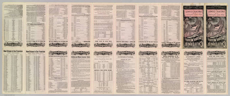
Southern Pacific Company
Full Title
(Covers to:) California, Texas, Mexico And Arizona Southern Pacific Co. "Sunset route" from New Orleans to the Pacific Coast ... January, 1892. American Bank Note Co., N.Y.
List No
3139A
Note
Self wrapper cover in color, illustrated.
Author
Southern Pacific Company
Full Title
California, Texas, Mexico And Arizona Southern Pacific Co. "Sunset route" from New Orleans to the Pacific Coast ... January, 1892. American Bank Note Co., N.Y.
List No
3139B
Note
Timetables and travel information (20 p.) including self wrapper cover in color, illustrated. Folded to 21 x 10 cm.
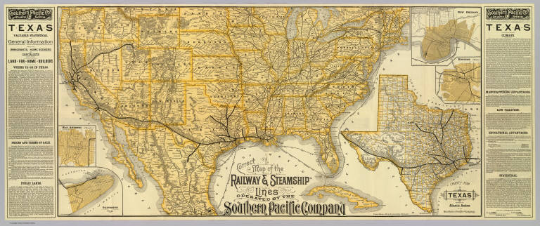
Author
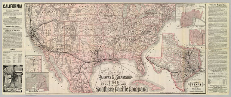
Southern Pacific Company
Full Title
Correct map of the railway & steamship lines operated by the Southern Pacific Company [United States and Mexico]. Poole Bros., Map Engravers, Chicago. (inset) County map of Texas showing the Atlantic System of the Southern Pacific Company. (inset) San Francisco, California. (inset) Los Angeles, California. (inset) New Orleans. (inset) San Antonio, Texas.
List No
3139.001
Note
Col. map with 5 insets. Relief shown by hachures. Shows connecting steamship routes from New York to New Orleans. Text descriptions of California and Texas. Interior view of Sleeping Car.
Author
Atchison, Topeka, and Santa Fe Railroad Company
Full Title
(Covers to) Santa Fe Route. Official guide, main lines, branches and connections. Traffic Department, Topeka, Kansas. August, 1888. Rand, McNally & Co., Printers, Chicago.
List No
3342A
Note
Tan cardboard printed with above title against a dark blue and black background.
Author
Atchison, Topeka, and Santa Fe Railroad Company
Full Title
Santa Fe Route. Official guide, main lines, branches and connections. Traffic Department, Topeka, Kansas. August, 1888. Rand, McNally & Co., Printers, Chicago.
List No
3342.001
Note
Relief shown by hachures. Covers area from Chicago west and south to Veracruz. Profiles: Elevations between San Bernardino and Los Angeles -- Elevations between Barstow and National City -- Elevations between Kansas City and San Francisco -- Elevations between Kansas City and Mexico.
Author
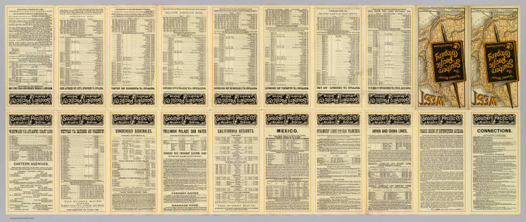
Southern Pacific Company
Full Title
(Covers to) "Sunset Route" The Southern Pacific Company Atlantic System. West. Poole Bros. Printers and Engravers, Chicago. (1884)
List No
5234A
Note
Folded to pocket map size. Verso has timetables. In full printed color, folding, self wrappers.
Author
Southern Pacific Company
Full Title
(Text Page to) "Sunset Route" The Southern Pacific Company Atlantic System. West. Poole Bros. Printers and Engravers, Chicago. (1884)
List No
5234B
Note
(20) p. on 1 sheet. Includes text, timetables and fare information.
Author
Southern Pacific Company
Full Title
Correct map of the railway & steamship lines operated by the Southern Pacific Company. (with) County map of Texas showing the Atlantic System of the Southern Pacific Company. (with) New Orleans. (with) Houston, Texas. (with) San Antonio, Texas. (with) Galveston, Texas. (1884)
List No
5234.001
Note
Relief shown by hachures. Covers most of the United States and northern and central Mexico, with shipping routes to Havana. Texas map at (ca. 1:4,800,000) scale. City maps are small scale showing street patterns, railroad, stations, etc. Text in side panels.
Author
[Missouri Pacific Railway Company, Rand McNally and Company]
Full Title
Map of the South West Railway System. Missouri Pacific Ry., Central Branch U.P. R.R., Missouri, Kansas & Texas Ry., Texas and Pacific Ry., St. Louis, Iron Mountn. and Southern Ry., International & Great Northern R.R., St. Louis, Ft. Scott & Wichita R.R. and their connections. Copyright, 1886, by Rand, McNally & Co., Map Publishers, Chicago ...
List No
5239.001
Note
Col. map. Relief shown by hachures. Covers also northern and central Mexico, and shows steamship routes to Veracruz and Havana. Includes list of agents, Pullman fare table, illus. and text.
Author
Chicago, Milwaukee, and St. Paul Railway Company
Full Title
(Covers to) Chicago Milwaukee and St. Paul Railway. Chicago, Milwaukee, St. Paul & Minneapolis ... Electric-lighted and steam-heated vestibuled trains. Rand, McNally & Co., Printers, Chicago.
List No
5247A
Author
Chicago, Milwaukee, and St. Paul Railway Company
Full Title
(Text Page to) Chicago Milwaukee and St. Paul Railway. Chicago, Milwaukee, St. Paul & Minneapolis ... Electric-lighted and steam-heated vestibuled trains. Rand, McNally & Co., Printers, Chicago.
List No
5247B
Note
30 p. text on 1 sheet. Includes timetables, text, etc.
Author
Chicago, Milwaukee, and St. Paul Railway Company
Full Title
Map of the Chicago-Milwaukee & St. Paul Ry. and connections. Rand, McNally & Co., Printers, Chicago. Matthews-Northrup & Co., Buffalo, N.Y. (with) Map of Mexico. (with inset of world)
List No
5247.001
Note
Relief shown by hachures. State boundaries in outline color. Map of Mexico at (ca. 1:12,400,000) scale.
Author
Atlantic Coast Line Railroad Company
Full Title
(Covers to) The Atlantic Coast Line north and south ... C.G. Crawford, Printer and Stationer, 49 & 51 Park Place N.Y. September 7, 1885.
List No
5274A
Author
Atlantic Coast Line Railroad Company
Full Title
(Text Page to) The Atlantic Coast Line north and south ... C.G. Crawford, Printer and Stationer, 49 & 51 Park Place N.Y. September 7, 1885.
List No
5274B
Note
(10) p. text on 1 sheet. Timetables, directory of agents, self wrappers.
Author
Atlantic Coast Line Railroad Company
Full Title
Map of the Atlantic Coast Line of railways & connections.
List No
5274.001
Note
Relief shown by hachures. Inset maps: (The West, Mexico and Central America) -- (Florida). Also shows steamship routes from New York to Norfolk, and in the Gulf of Mexico. Includes text.
Author
Atchison, Topeka, and Santa Fe Railroad Company
Full Title
(Covers to) The California Limited. Pictures by C.D. Williams. 1903-1904 Santa Fe. Copyright, 1903, by Geo. T. Nicholson.
List No
5277A
Author
Atchison, Topeka, and Santa Fe Railroad Company
Full Title
(Title Page) The California Limited. Pictures by C.D. Williams. 1903-1904 Santa Fe. Copyright, 1903, by Geo. T. Nicholson.
List No
5277B
Note
Illustrated title page printed in yellow and black.
Author
Atchison, Topeka, and Santa Fe Railroad Company
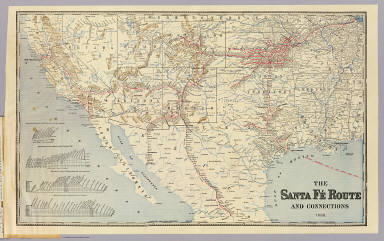
Full Title
Route of the California Limited -- "Santa Fe all the way."
List No
5277.001
Note
Shows route from Chicago to San Francisco and San Diego with connecting routes including those in northern Mexico.
1-22 of 22
|