|
Author
Ethridge Co.
Full Title
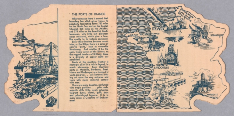
The Ports of France.
List No
9499.002
Note
Date estimated.
Author
Ethridge Co.
Full Title
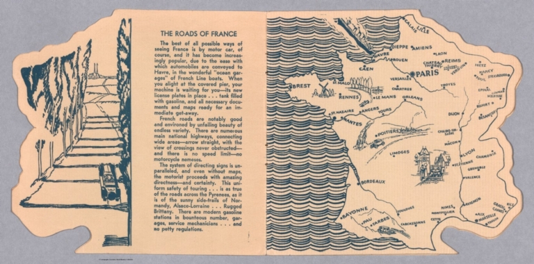
The Roads of France.
List No
9499.003
Note
Date estimated.
Author
Ethridge Co.
Full Title
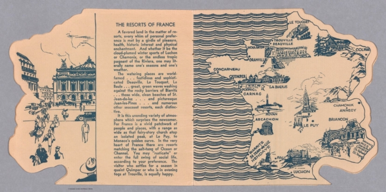
The Resorts of France.
List No
9499.004
Note
Date estimated.
Author
Ethridge Co.
Full Title
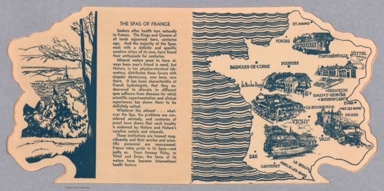
The Spas of France.
List No
9499.005
Note
Date estimated.
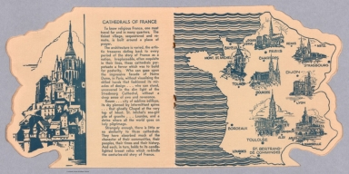
Author
Ethridge Co.
Full Title
Cathedrals of France.
List No
9499.006
Note
Date estimated.
Author
Ethridge Co.
Full Title
The Chateaux of France.
List No
9499.007
Note
Date estimated.
Author
Ethridge Co.
Full Title
The Wines of France.
List No
9499.008
Note
Date estimated.
Author
Ethridge Co.
Full Title
The Fromages of France.
List No
9499.009
Note
Date estimated.
Author
[Apian, Peter, 1495-1552, Gemma, Frisius, 1508-1555, Gaultherot, Vivant]
Full Title
(Text Page to) Prima pars huius libri de cosmographiæ & geographiæ principiis. (28)
List No
14336.038
Note
First part to Cosmographica Petri Apiani. Title translates to: The first part of this book, on cosmographic and geographic principles. Includes nineteenth chapter: De speculo cosmographico : Caput XIX. With woodcut initial letters and a map showing part of France, including Paris. All four sides of the map feature a hands with fingers pinching strings that serve as latitudinal and longitudinal lines. First part spans pages 1-30.
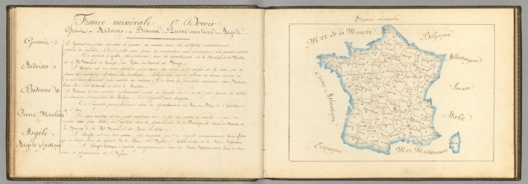
Author
Giraud, Eugénie
Full Title
France minérale (1). (with) (Text Page to) France minérale : 1er devoir.
List No
14321.030
Note
Manuscript map of France, in ink and colored pencil. Title translates to: Minerals of France. Shows international and administrative boundaries, and coastline. Features mineral resources, including grains, slates, asphalt, millstone, clay and plastic clay. Map is 17 x 26 cm, on sheet 21 x 31 cm. Accompanied by descriptive text and a legend on facing page. First map appearing in the second part of atlas, Principale production de la France en général [= Main production of France in general]. (with) Descriptive text for map, France minérale, on facing page. Text title translates to: Minerals of France : 1st part. Includes sections: Grains -- Ardoises -- Bitume -- Piere meuliére -- Argile -- Argile plastique [= Grains -- Slates -- Asphalt -- Millstone -- Clay -- Plastic clay]. Appears in the second part of atlas, Principale production de la France en général [= Main production of France in general].
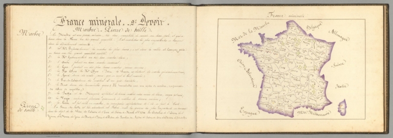
Author
Giraud, Eugénie
Full Title
France minérale (2). (with) (Text Page to) France minérale : 2e devoir.
List No
14321.031
Note
Manuscript map of France, in ink and colored pencil. Title translates to: Minerals of France. Shows international and administrative boundaries, and coastline. Features mineral resources, including marble and cut stone. Map is 17 x 25 cm, on sheet 21 x 31 cm. Accompanied by descriptive text and a legend on facing page. Second map appearing in the second part of atlas, Principale production de la France en général [= Main production of France in general]. (with) Descriptive text for map, France minérale, on facing page. Text title translates to: Minerals of France : 2nd part. Includes sections: Marbre -- Pierre de taille [= Marble -- Cut stone]. Appears in the second part of atlas, Principale production de la France en général [= Main production of France in general].
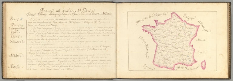
Author
Giraud, Eugénie
Full Title
France minérale (3). (with) (Text Page to) France minérale : 3e devoir.
List No
14321.032
Note
Manuscript map of France, in ink and colored pencil. Title translates to: Minerals of France. Shows international and administrative boundaries, and coastline. Features mineral resources, including chalk, lithographic stone, sandstone, plaster, cement, alabaster and china clay. Map is 17 x 26 cm, on sheet 21 x 31 cm. Accompanied by descriptive text and a legend on facing page. Third map appearing in the second part of atlas, Principale production de la France en général [= Main production of France in general]. (with) Descriptive text for map, France minérale, on facing page. Text title translates to: Minerals of France : 3rd part. Includes sections: Craie -- Pierre lithographique -- Grès -- Plâtze -- Cimens -- Albâtre -- Kaolin [= Chalk -- Lithographic stone -- Sandstone -- Plaster -- Cement - Alabaster - China clay]. Appears in the second part of atlas, Principale production de la France en général [= Main production of France in general].
Author
Giraud, Eugénie
Full Title
France minérale (4). (with) (Text Page to) France minérale : 4e devoir.
List No
14321.033
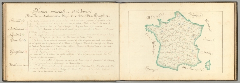
Note
Manuscript map of France, in ink and colored pencil. Title translates to: Minerals of France. Shows international and administrative boundaries, and coastline. Features mineral resources, including coal, anthracite, lignite, graphite and saline matter. Map is 17 x 26 cm, on sheet 21 x 31 cm. Accompanied by descriptive text and a legend on facing page. Fourth map appearing in the second part of atlas, Principale production de la France en général [= Main production of France in general]. (with) Descriptive text for map, France minérale, on facing page. Text title translates to: Minerals of France : 4th part. Includes sections: Houille -- Anthracite -- Lignite-- Courbe -- Graphite -- Matières salines [= Coal -- Anthracite -- Lignite -- Curve -- Graphite -- Saline matter]. Appears in the second part of atlas, Principale production de la France en général [= Main production of France in general].
Author
Giraud, Eugénie
Full Title
France minérale (5). (with) (Text Page to) France minérale : 5e devoir.
List No
14321.034
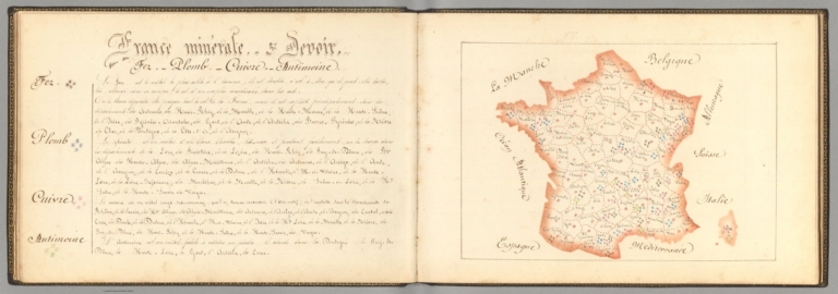
Note
Manuscript map of France, in ink and colored pencil. Title translates to: Minerals of France. Shows international and administrative boundaries, and coastline. Features mineral resources, including iron, lead, copper and antimony. Map is 17 x 25 cm, on sheet 21 x 31 cm. Accompanied by descriptive text and a legend on facing page. Fifth map appearing in the second part of atlas, Principale production de la France en général [= Main production of France in general]. (with) Descriptive text for map, France minérale, on facing page. Text title translates to: Minerals of France : 5th part. Includes sections: Fer -- Plomb -- Cuivre -- Antimoine [= Iron -- Lead -- Copper -- Antimony]. Appears in the second part of atlas, Principale production de la France en général [= Main production of France in general].
Author
Giraud, Eugénie
Full Title
France minérale (6). (with) (Text Page to) France minérale : 6e devoir.
List No
14321.035
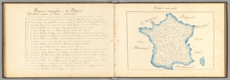
Note
Manuscript map of France, in ink and colored pencil. Title translates to: Minerals of France. Shows international and administrative boundaries, and coastline. Features the main sources of mineral water. Map is 17 x 25 cm, on sheet 21 x 31 cm. Accompanied by descriptive text and a legend on facing page. Sixth map appearing in the second part of atlas, Principale production de la France en général [= Main production of France in general]. (with) Descriptive text for map, France minérale, on facing page. Text title translates to: Minerals of France : 6th part. Includes section: Principales sources d'eaux minérales [= Main sources of mineral water]. Appears in the second part of atlas, Principale production de la France en général [= Main production of France in general].
Author
Giraud, Eugénie
Full Title
France végétale (1). (with) (Text Page to) France végétale : 1er devoir.
List No
14321.036
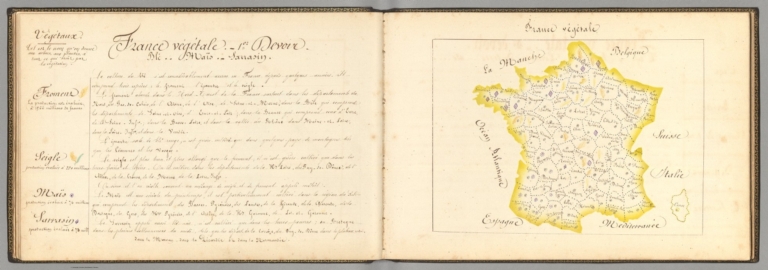
Note
Manuscript map of France, in ink and colored pencil. Title translates to: Vegetables of France. Shows international and administrative boundaries, and coastline. Features agricultural products - with pictorial representation - including wheat, rye, corn and buckwheat. Map is 17 x 23 cm, on sheet 21 x 31 cm. Accompanied by descriptive text and a legend on facing page. Seventh map appearing in the second part of atlas, Principale production de la France en général [= Main production of France in general]. (with) Descriptive text for map, France végétale, on facing page. Text title translates to: Vegetable of France : 1st part. Includes sections: Froment -- Seigle -- Maïs -- Sarrasin [= Wheat -- Rye -- Corn -- Buckwheat]. Appears in the second part of atlas, Principale production de la France en général [= Main production of France in general].
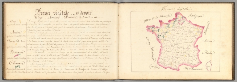
Author
Giraud, Eugénie
Full Title
France végétale (2). (with) (Text Page to) France végétale : 2e devoir.
List No
14321.037
Note
Manuscript map of France, in ink and colored pencil. Title translates to: Vegetables of France. Shows international and administrative boundaries, and coastline. Features agricultural products - with pictorial representation - including barley, oats, potatoes, beet roots and hemp. Map is 17 x 25 cm, on sheet 21 x 31 cm. Accompanied by descriptive text and a legend on facing page. Eighth map appearing in the second part of atlas, Principale production de la France en général [= Main production of France in general]. (with) Descriptive text for map, France végétale, on facing page. Text title translates to: Vegetable of France : 2nd part. Includes sections: Orge -- Avoine -- Pomme de terre -- Betterave -- Chanvre [= Barley -- Oats -- Potato -- Beet root - Hemp]. Appears in the second part of atlas, Principale production de la France en général [= Main production of France in general].
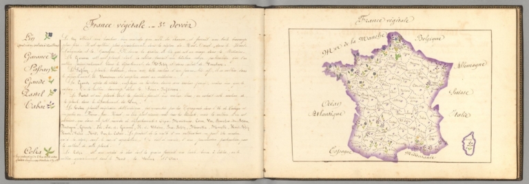
Author
Giraud, Eugénie
Full Title
France végétale (3). (with) (Text Page to) France végétale : 3e devoir.
List No
14321.038
Note
Manuscript map of France, in ink and colored pencil. Title translates to: Vegetables of France. Shows international and administrative boundaries, and coastline. Features agricultural products - with pictorial representation - including flax, saffron and rapeseed. Map is 17 x 25 cm, on sheet 21 x 31 cm. Accompanied by descriptive text and a legend on facing page. Ninth map appearing in the second part of atlas, Principale production de la France en général [= Main production of France in general]. (with) Descriptive text for map, France végétale, on facing page. Text title translates to: Vegetable of France : 3rd part. Includes sections: Lin ... Safran ... Colza [= Flax ... Saffron ... Rapeseed]. Appears in the second part of atlas, Principale production de la France en général [= Main production of France in general].
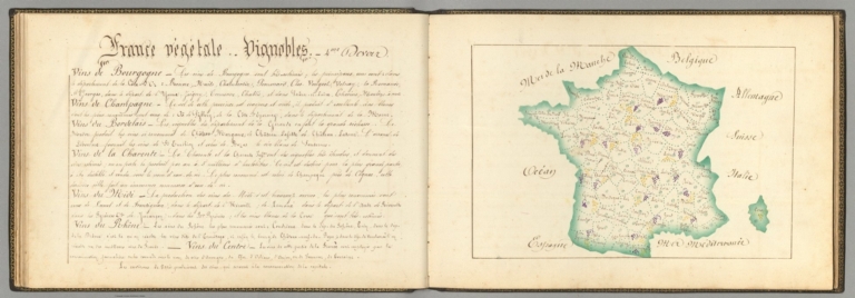
Author
Giraud, Eugénie
Full Title
France végétale (4). (with) (Text Page to) France végétale : Vignobles : 4me devoir.
List No
14321.039
Note
Manuscript map of France, in ink and colored pencil. Title translates to: Vegetables of France. Shows international and administrative boundaries, and coastline. Features vineyards - with pictorial representation - including in the regions of Bourgogne [Burgundy], Champagne, Bordelais and Rhône. Map is 17 x 25 cm, on sheet 21 x 31 cm. Accompanied by descriptive text and a legend on facing page; title taken from text. Tenth map appearing in the second part of atlas, Principale production de la France en général [= Main production of France in general]. (with) Descriptive text for map, France végétale, on facing page. Title translates to: Vegetable of France : Vineyards : 4th part. Includes sections on the regions of Bourgogne [Burgundy], Champagne, Bordelais and Rhône. Appears in the second part of atlas, Principale production de la France en général [= Main production of France in general].
Author
French Geographical Game
Full Title
(Text page to) Jeux Instructifs Depose France Provinces & Departments Geographie. (Entitled) Etude Geographique de la France.
List No
2948B
Note
Four pages of text (one reproduced here) discussing a study of France and one of Europe. Date estimated.
Author
[Dower, John, Higgins, W.M.]
Full Title
(Text Page) France.
List No
0247.032
Author
Levasseur, Victor.
Full Title
(Text Page to) Atlas National Illustre des 86 Departments et des Possessions De La France. Tableau Statistique De La Fance Et De Ses Colonies. Donnant la nomenclature des Cartes contenues dans le Nouvel Atlas illustre. Grave par Burty. rue de la Vielle Estrapade, 3. Paris. Impie. Lemercier rue de Seine 57, Paris. (1856)
List No
0427C
Note
Table of 83 departments and corresponding statistics. Brief discussion of government, physical geography, soil, agricultural products, personages, industry, commerce, and colonies. Steel engraving.
Author
[Ortelius, Abraham, 1527-1598, Vrients, Jan Baptista]
Full Title
(Text Page) Il Ducato Di Borgogna. 38
List No
10001.134
Author
[Touring club italiano, Funk & Wagnalls Company.]
Full Title
(Legend to) Francia. Propr. Artistico-letteraria del T.C.I. Ufficio cartografico del T.C.I. (1929)
List No
1012AT
Note
Explanation to map.
Author
[Touring club italiano, Funk & Wagnalls Company.]
Full Title
(Legend to) Francia, foglio nord. Propr. Artistico-letteraria del T.C.I. Ufficio cartografico del T.C.I. (1929)
List No
1012AU
Note
Explanation to map.
Author
[Touring club italiano, Funk & Wagnalls Company.]
Full Title
(Legend to) Francia, foglio sud. Propr. Artistico-letteraria del T.C.I. Ufficio cartografico del T.C.I. (1929)
List No
1012AV
Note
Explanation to map.
Author
[Touring club italiano, Funk & Wagnalls Company.]
Full Title
(Legend to) Spagna e Portogallo, Espana y Portugal. Propr. Artistico-letteraria del T.C.I. Ufficio cartografico del T.C.I. (1929)
List No
1012AW
Note
Explanation to map.
Author
[Mercator, Gerhard, 1512-1594, Hondius, Iodocus, 1563-1612]
Full Title
L'Isle de France : Parisiensis Ager. (to accompany) Atlas minor Gerardi Mercatoris.
List No
11201.173
Note
Map of the region of France around Paris. Relief shown pictorially.
Author
[LeSage, A., Las Cases, Emmanuel-Auguste-Dieudonne]
Full Title
La France en 1812. (with) Formation du territoire Francois. (to accompany) Atlas historique, genealogique, chronologique et geographique de A. LeSage (Comte de Las Cases). Nouvelle edition ou Reimpression (1829).
List No
11339.017
Note
2 hand colored maps of France, with textual details and tables pertaining to the area on exploration, history, and discoveries at the time. Includes legend. Relief shown by hachures.
Author
[Coronelli, Vincenzo (1650-1718), Accademia cosmografica degli Argonauti.]
Full Title
(Text Page to) Isolario del P. Coronelli. Isole alle Spiagge della Normandia. (with) Dieppe. (to accompany) Isolario descrittione geografico-historica, sacro-profana, antico-moderna ... e in supplimento dei XIV volumi del Bleau. Tomo II dell' Atlante veneto. Opera, e Studio del P. Maestro Vincenzo Coronelli ... A Spese dell Auttore MDCLXXXXVI.
List No
11391.061
Note
Text to Isolario del P. Coronelli. Parte II. Isole alle Spiagge della Normandia. With engraved plan of Dieppe.
Author
[Coronelli, Vincenzo (1650-1718), Accademia cosmografica degli Argonauti.]
Full Title
(Text Page to) Isolario del P. Coronelli. (with) Havre de Grace. (to accompany) Isolario descrittione geografico-historica, sacro-profana, antico-moderna ... e in supplimento dei XIV volumi del Bleau. Tomo II dell' Atlante veneto. Opera, e Studio del P. Maestro Vincenzo Coronelli ... A Spese dell Auttore MDCLXXXXVI.
List No
11391.063
Note
Text to Isolario del P. Coronelli. Parte II. With engraved plan of the city and port of Havre de Grace were officially founded by King Fran��ois I in 1517.
Author
[Coronelli, Vincenzo (1650-1718), Accademia cosmografica degli Argonauti.]
Full Title
(Text Page to) Isolario del P. Coronelli. (with) St. Malo. (with) Le Conquet porto della Bretagna. (to accompany) Isolario descrittione geografico-historica, sacro-profana, antico-moderna ... e in supplimento dei XIV volumi del Bleau. Tomo II dell' Atlante veneto. Opera, e Studio del P. Maestro Vincenzo Coronelli ... A Spese dell Auttore MDCLXXXXVI.
List No
11391.064
Note
Text to Isolario del P. Coronelli. Parte II. With engraved panoramic view of the city of Saint Malo and plan of the city and port of Le Conquet.
Author
[Coronelli, Vincenzo (1650-1718), Accademia cosmografica degli Argonauti.]
Full Title
(Text Page to) Isolario del P. Coronelli. (with) Isola Bouchart. (to accompany) Isolario descrittione geografico-historica, sacro-profana, antico-moderna ... e in supplimento dei XIV volumi del Bleau. Tomo II dell' Atlante veneto. Opera, e Studio del P. Maestro Vincenzo Coronelli ... A Spese dell Auttore MDCLXXXXVI.
List No
11391.066
Note
Text to Isolario del P. Coronelli. Parte II. With engraved panoramic view of Isola Bouchart.
Author
[Coronelli, Vincenzo (1650-1718), Accademia cosmografica degli Argonauti.]
Full Title
(Text Page to) Isolario del P. Coronelli. (with) Isole Su le Spiagge del Poitu. (with) Alle Poci del Fiume Garonna. (to accompany) Isolario descrittione geografico-historica, sacro-profana, antico-moderna ... e in supplimento dei XIV volumi del Bleau. Tomo II dell' Atlante veneto. Opera, e Studio del P. Maestro Vincenzo Coronelli ... A Spese dell Auttore MDCLXXXXVI.
List No
11391.067
Note
Text to Isolario del P. Coronelli. Parte II. With engraved plans of Isola di Narmoustier alle bocche del fiume Loira and Bocca del Fiume Garonna.
Author
[Coronelli, Vincenzo (1650-1718), Accademia cosmografica degli Argonauti.]
Full Title
(Text Page to) Isolario del P. Coronelli. Isola del re. o di S.Martino. (with) Forte di S. Martino. (to accompany) Isolario descrittione geografico-historica, sacro-profana, antico-moderna ... e in supplimento dei XIV volumi del Bleau. Tomo II dell' Atlante veneto. Opera, e Studio del P. Maestro Vincenzo Coronelli ... A Spese dell Auttore MDCLXXXXVI.
List No
11391.069
Note
Text to Isolario del P. Coronelli. Parte II. With engraved plan of fort Saint Martin.
Author
[Coronelli, Vincenzo (1650-1718), Accademia cosmografica degli Argonauti.]
Full Title
(Text Page to) Isolario del P. Coronelli. (with) Isola d'Oleron. (with) La Cittadella d'Oleron. (to accompany) Isolario descrittione geografico-historica, sacro-profana, antico-moderna ... e in supplimento dei XIV volumi del Bleau. Tomo II dell' Atlante veneto. Opera, e Studio del P. Maestro Vincenzo Coronelli ... A Spese dell Auttore MDCLXXXXVI.
List No
11391.070
Note
Text to Isolario del P. Coronelli. Parte II. With engraved panoramic view of Isola d'Oleron and plan of La Cittadella d'Oleron.
Author
[Henry, Jacques (1835-1842), Corbin, Alexandre, Rivaux, Auguste]
Full Title
1. Ain : Bourg (Bresse). Belley. Gex. Nantua.Trevoux. (to accompany) Nouvelle Geographie et statistique de la France. Alger et la Belgique. suivie. d'un traite sur le Monde entier. Orne de 95 cartes et approuvee de l'Universite. Par J. Henry, 4e. edition. Revue, corrigee et augmentee par l'auteur, Rivaux et Corbin, lithographes - editeurs a Tours. (With) Atlas de la France, Tours. Imprimerie Lithographique d'Alexdre. Corbin 1842.
List No
11457.030
Note
Uncolored map of Ain department, surrounded by ornamental cartouche containing illustration and portrait of Michaud. Includes descriptive text "Remarques & curiosites". Shows administrative boundaries, capital, major cities, towns, rivers, mountains, products and industry. Relief shown by hachures.
Author
[Henry, Jacques (1835-1842), Corbin, Alexandre, Rivaux, Auguste]
Full Title
2. Aisne : Laon (Il de France et Picardie). Chateau-Thierry. Soissons. St. Quentin. Vervins. (to accompany) Nouvelle Geographie et statistique de la France. Alger et la Belgique. suivie. d'un traite sur le Monde entier. Orne de 95 cartes et approuvee de l'Universite. Par J. Henry, 4e. edition. Revue, corrigee et augmentee par l'auteur, Rivaux et Corbin, lithographes - editeurs a Tours. (With) Atlas de la France, Tours. Imprimerie Lithographique d'Alexdre. Corbin 1842.
List No
11457.031
Note
Uncolored map of Aisne department, surrounded by ornamental cartouche containing illustration and portrait of La Fontaine. Includes descriptive text "Remarques & curiosites". Shows administrative boundaries, capital, major cities, towns, rivers, mountains, products and industry. Relief shown by hachures.
Author
[Henry, Jacques (1835-1842), Corbin, Alexandre, Rivaux, Auguste]
Full Title
3. Allier. Moulins (Bourbonnais). Montlucon. Gannat. La Palisse. (to accompany) Nouvelle Geographie et statistique de la France. Alger et la Belgique. suivie. d'un traite sur le Monde entier. Orne de 95 cartes et approuvee de l'Universite. Par J. Henry, 4e. edition. Revue, corrigee et augmentee par l'auteur, Rivaux et Corbin, lithographes - editeurs a Tours. (With) Atlas de la France, Tours. Imprimerie Lithographique d'Alexdre. Corbin 1842.
List No
11457.032
Note
Uncolored map of Allier department, surrounded by ornamental cartouche containing illustration and portrait of Villars. Includes descriptive text "Remarques & curiosites". Shows administrative boundaries, capital, major cities, towns, rivers, mountains, products and industry. Relief shown by hachures.
Author
[Henry, Jacques (1835-1842), Corbin, Alexandre, Rivaux, Auguste]
Full Title
4. Basses Alpes. Digne (Provence). Barcelonnette. Castellane. Forcalquier. Sisteron. (to accompany) Nouvelle Geographie et statistique de la France. Alger et la Belgique. suivie. d'un traite sur le Monde entier. Orne de 95 cartes et approuvee de l'Universite. Par J. Henry, 4e. edition. Revue, corrigee et augmentee par l'auteur, Rivaux et Corbin, lithographes - editeurs a Tours. (With) Atlas de la France, Tours. Imprimerie Lithographique d'Alexdre. Corbin 1842.
List No
11457.033
Note
Uncolored map of Basses Alpes Department, surrounded by ornamental cartouche containing illustration and portrait of Cassendi (Piere). Includes descriptive text "Remarques & curiosites". Shows administrative boundaries, capital, major cities, towns, rivers, mountains, products and industry. Relief shown by hachures.
Author
[Henry, Jacques (1835-1842), Corbin, Alexandre, Rivaux, Auguste]
Full Title
5. Hautes Alpes. Gap (Dauphine). Briancon. Embrun. (to accompany) Nouvelle Geographie et statistique de la France. Alger et la Belgique. suivie. d'un traite sur le Monde entier. Orne de 95 cartes et approuvee de l'Universite. Par J. Henry, 4e. edition. Revue, corrigee et augmentee par l'auteur, Rivaux et Corbin, lithographes - editeurs a Tours. (With) Atlas de la France, Tours. Imprimerie Lithographique d'Alexdre. Corbin 1842.
List No
11457.034
Note
Uncolored map of Hautes Alpes department, surrounded by ornamental cartouche containing illustration and portrait of Francois Lesdiguieres. Includes descriptive text "Remarques & curiosites". Shows administrative boundaries, capital, major cities, towns, rivers, mountains, products and industry. Relief shown by hachures.
Author
[Henry, Jacques (1835-1842), Corbin, Alexandre, Rivaux, Auguste]
Full Title
6. Ardeche. Privas (Languedoc). Tournon. L'Argentiere. (to accompany) Nouvelle Geographie et statistique de la France. Alger et la Belgique. suivie. d'un traite sur le Monde entier. Orne de 95 cartes et approuvee de l'Universite. Par J. Henry, 4e. edition. Revue, corrigee et augmentee par l'auteur, Rivaux et Corbin, lithographes - editeurs a Tours. (With) Atlas de la France, Tours. Imprimerie Lithographique d'Alexdre. Corbin 1842.
List No
11457.035
Note
Uncolored map of Ardeche department, surrounded by ornamental cartouche containing illustration and portrait of Boissy D'Anglas. Includes descriptive text "Remarques & curiosites". Shows administrative boundaries, capital, major cities, towns, rivers, mountains, products and industry. Relief shown by hachures.
Author
[Henry, Jacques (1835-1842), Corbin, Alexandre, Rivaux, Auguste]
Full Title
7. Ardennes. Mezieres (Champagne). Rocroy. Sedan. Rethel. Vouziers. (to accompany) Nouvelle Geographie et statistique de la France. Alger et la Belgique. suivie. d'un traite sur le Monde entier. Orne de 95 cartes et approuvee de l'Universite. Par J. Henry, 4e. edition. Revue, corrigee et augmentee par l'auteur, Rivaux et Corbin, lithographes - editeurs a Tours. (With) Atlas de la France, Tours. Imprimerie Lithographique d'Alexdre. Corbin 1842.
List No
11457.036
Note
Uncolored map of Ardennes department, surrounded by ornamental cartouche containing illustration and portrait of Turenne. Includes descriptive text "Remarques & curiosites". Shows administrative boundaries, capital, major cities, towns, rivers, mountains, products and industry. Relief shown by hachures.
Author
[Henry, Jacques (1835-1842), Corbin, Alexandre, Rivaux, Auguste]
Full Title
8. Ariege. Foix (Comte de Foix et Languedoc). Pamiers. St. Girons. (to accompany) Nouvelle Geographie et statistique de la France. Alger et la Belgique. suivie. d'un traite sur le Monde entier. Orne de 95 cartes et approuvee de l'Universite. Par J. Henry, 4e. edition. Revue, corrigee et augmentee par l'auteur, Rivaux et Corbin, lithographes - editeurs a Tours. (With) Atlas de la France, Tours. Imprimerie Lithographique d'Alexdre. Corbin 1842.
List No
11457.037
Note
Uncolored map of Ariege department, surrounded by ornamental cartouche containing illustration and portrait of Clausel. Includes descriptive text "Remarques & curiosites". Shows administrative boundaries, capital, major cities, towns, rivers, mountains, products and industry. Relief shown by hachures.
Author
[Henry, Jacques (1835-1842), Corbin, Alexandre, Rivaux, Auguste]
Full Title
9. Aube. Troyes (Chanmpagne). Nogentsur-Seins. Arcis-Sur-Aube. Bar-Sur-Seine. Bar-Sur-Aube. (to accompany) Nouvelle Geographie et statistique de la France. Alger et la Belgique. suivie. d'un traite sur le Monde entier. Orne de 95 cartes et approuvee de l'Universite. Par J. Henry, 4e. edition. Revue, corrigee et augmentee par l'auteur, Rivaux et Corbin, lithographes - editeurs a Tours. (With) Atlas de la France, Tours. Imprimerie Lithographique d'Alexdre. Corbin 1842.
List No
11457.038
Note
Uncolored map of Aube department, surrounded by ornamental cartouche containing illustration and portrait of Thenard. Includes descriptive text "Remarques & curiosites". Shows administrative boundaries, capital, major cities, towns, rivers, mountains, products and industry. Relief shown by hachures.
Author
[Henry, Jacques (1835-1842), Corbin, Alexandre, Rivaux, Auguste]
Full Title
10. Aude. Carcassonne (Languedoc). Narbonne. Castelnaudary. Limoux. (to accompany) Nouvelle Geographie et statistique de la France. Alger et la Belgique. suivie. d'un traite sur le Monde entier. Orne de 95 cartes et approuvee de l'Universite. Par J. Henry, 4e. edition. Revue, corrigee et augmentee par l'auteur, Rivaux et Corbin, lithographes - editeurs a Tours. (With) Atlas de la France, Tours. Imprimerie Lithographique d'Alexdre. Corbin 1842.
List No
11457.039
Note
Uncolored map of Aude department, surrounded by ornamental cartouche containing illustration and portrait of Andreossy. Includes descriptive text "Remarques & curiosites". Shows administrative boundaries, capital, major cities, towns, rivers, mountains, products and industry. Relief shown by hachures.
Author
[Henry, Jacques (1835-1842), Corbin, Alexandre, Rivaux, Auguste]
Full Title
11. Aveyron. Rodex (Bouergue) Espalion. Miljau. Saint-Affrique. Villefranche. (to accompany) Nouvelle Geographie et statistique de la France. Alger et la Belgique. suivie. d'un traite sur le Monde entier. Orne de 95 cartes et approuvee de l'Universite. Par J. Henry, 4e. edition. Revue, corrigee et augmentee par l'auteur, Rivaux et Corbin, lithographes - editeurs a Tours. (With) Atlas de la France, Tours. Imprimerie Lithographique d'Alexdre. Corbin 1842.
List No
11457.040
Note
Uncolored map of Aveyron department, surrounded by ornamental cartouche containing illustration and portrait of De Belle-Isle. Includes descriptive text "Remarques & curiosites". Shows administrative boundaries, capital, major cities, towns, rivers, mountains, products and industry. Relief shown by hachures.
Author
[Henry, Jacques (1835-1842), Corbin, Alexandre, Rivaux, Auguste]
Full Title
12. Bouches du Rhone. Marseille (Provence). Aix. Arles. (to accompany) Nouvelle Geographie et statistique de la France. Alger et la Belgique. suivie. d'un traite sur le Monde entier. Orne de 95 cartes et approuvee de l'Universite. Par J. Henry, 4e. edition. Revue, corrigee et augmentee par l'auteur, Rivaux et Corbin, lithographes - editeurs a Tours. (With) Atlas de la France, Tours. Imprimerie Lithographique d'Alexdre. Corbin 1842.
List No
11457.041
Note
Uncolored map of Bouches du Rhone department, surrounded by ornamental cartouche containing illustration and portrait of Mirabeau. Includes descriptive text "Remarques & curiosites". Shows administrative boundaries, capital, major cities, towns, rivers, mountains, products and industry. Relief shown by hachures.
Author
[Henry, Jacques (1835-1842), Corbin, Alexandre, Rivaux, Auguste]
Full Title
13. Calvados. Caen (Normandie). Bayeux. Falaise. Lisieux. Pont-Leveque. Vire. (to accompany) Nouvelle Geographie et statistique de la France. Alger et la Belgique. suivie. d'un traite sur le Monde entier. Orne de 95 cartes et approuvee de l'Universite. Par J. Henry, 4e. edition. Revue, corrigee et augmentee par l'auteur, Rivaux et Corbin, lithographes - editeurs a Tours. (With) Atlas de la France, Tours. Imprimerie Lithographique d'Alexdre. Corbin 1842.
List No
11457.042
Note
Uncolored map of Calvados department, surrounded by ornamental cartouche containing illustration and portrait of Malherbe. Includes descriptive text "Remarques & curiosites". Shows administrative boundaries, capital, major cities, towns, rivers, mountains, products and industry. Relief shown by hachures.
Author
[Henry, Jacques (1835-1842), Corbin, Alexandre, Rivaux, Auguste]
Full Title
14. Cantal. Aurillac (Auvergne). Mauriac. Murat. S. Flour. (to accompany) Nouvelle Geographie et statistique de la France. Alger et la Belgique. suivie. d'un traite sur le Monde entier. Orne de 95 cartes et approuvee de l'Universite. Par J. Henry, 4e. edition. Revue, corrigee et augmentee par l'auteur, Rivaux et Corbin, lithographes - editeurs a Tours. (With) Atlas de la France, Tours. Imprimerie Lithographique d'Alexdre. Corbin 1842.
List No
11457.043
Note
Uncolored map of Cantal department, surrounded by ornamental cartouche containing illustration and portrait of Du Belloy. Includes descriptive text "Remarques & curiosites". Shows administrative boundaries, capital, major cities, towns, rivers, mountains, products and industry. Relief shown by hachures.
|