|
Author
[United States. Army Service Forces. Army Information Branch., Harrison, Richard Edes]
Full Title
Newsmap For the Armed Forces. 276th Week of the War - 158th Week of U.S. Participation.
List No
15947.001
Note
Duplicate of 9014.000 but with mailing envelope added.
Author
United States. Army Service Forces. Army Information Branch.
Full Title
South Burma and Thailand. Prepared In The R and A Branch OSS.
List No
15947.002
Note
Duplicate of 9014.000 but with mailing envelope added.
Author
[United States. Army Service Forces. Army Information Branch., Harrison, Richard Edes]
Full Title
(Covers to) NEWSMAP Monday, 25 December, 1944
List No
15947.003
Note
Duplicate of 9014.000 but with mailing envelope added.
Author
News Map of the Week, Inc.
Full Title
World News of the Week : Monday, Apr. 10, 1944. Covering period Mar. 31 to Apr. 6. Volume 6, No. 32. Published and copyrighted (weekly), 1944, by News Map of the Week, Inc., 1512 Orleans Street, Chicago, Illinois. Published in two sections : Section one. Lithographed in U. S. A.
List No
14167.000
Note
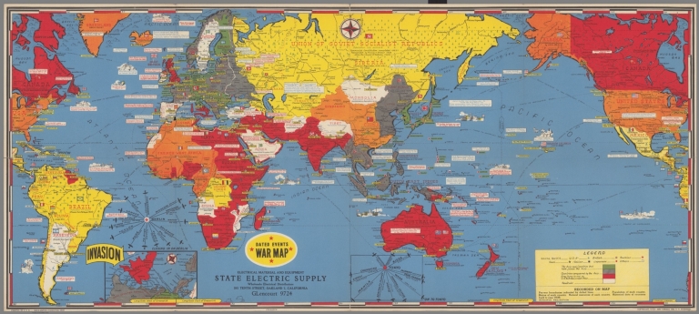
Lithographed world map, in color. Shows political boundaries and military events of World War II, from March 31 to April 6, 1944. Relief illustrated with hachures. Includes a key indicating the alignment of warring nations (United, Axis, and neutral). Descriptive text throughout, e.g.: Budapest bombed by Allied planes. Map indexed according to historical notes beneath map. Features photographs, illustrations, and international time zones. With two inset maps: Reference chart for Pan-American Day, April 14, 1944 -- The Russian battlefront. Map is 56 x 115 cm, on sheet 89 x 120 cm, folded to 31 x 23 cm.
Author
News Map of the Week, Inc.
Full Title
World News of the Week : Monday, Apr. 24, 1944. Covering period Apr. 14 to Apr. 20. Volume 6, No. 34. Published and copyrighted (weekly), 1944, by News Map of the Week, Inc., 1512 Orleans Street, Chicago, Illinois. Published in two sections : Section one. Lithographed in U. S. A.
List No
14168.000
Note
Lithographed world map, in color. Shows political boundaries and military events of World War II, from April 14 to 20, 1944. Relief illustrated with hachures. Descriptive text throughout, e.g.: Where tornado struck. Map indexed according to historical notes beneath map. Features photographs, illustrations, and international time zones. With three inset maps: (Japanese advance in India) -- The size of the United States -- The Army's global airways. Map is 56 x 115 cm, on sheet 89 x 120 cm, folded to 31 x 23 cm.
Author
News Map of the Week, Inc.
Full Title
World News of the Week : Monday, May 8, 1944. Covering period Apr. 28 to May 4. Volume 6, No. 36. Published and copyrighted (weekly), 1944, by News Map of the Week, Inc., 1512 Orleans Street, Chicago, Illinois. Published in two sections : Section one. Lithographed in U. S. A.
List No
14170.000
Note
Lithographed world map, in color. Shows political boundaries and military events of World War II, from April 28 to May 4, 1944. Relief illustrated with hachures. Descriptive text throughout, e.g.: Ft. Norman - Whitehorse oil pipeline opened. Map indexed according to historical notes beneath map. Features photographs, illustrations, and international time zones. With inset map: (European communication networks). Also, with two diagrams: (Photo flash bomb) -- Bombing tons dropped on Axis Europe. Map is 56 x 115 cm, on sheet 89 x 120 cm, folded to 31 x 23 cm.
Author
News Map of the Week, Inc.
Full Title
World News of the Week : Monday, Mar. 13, 1944. Covering period Mar. 3 to Mar. 9. Volume 6, No. 28. Published and copyrighted (weekly), 1944, by News Map of the Week, Inc., 1512 Orleans Street, Chicago, Illinois. Published in two sections : Section one. Lithographed in U. S. A.
List No
14171.000
Note
Lithographed world map, in color. Shows political boundaries and military events of World War II, from March 3 to 9, 1944. Relief illustrated with hachures. Includes a key indicating the alignment of warring nations (United, Axis, and neutral). Descriptive text throughout, e.g.: Reds cut main Nazi supply line. Map indexed according to historical notes beneath map. Features photographs, illustrations, and international time zones. With two inset maps: (South America) -- (Berlin). Also, with diagram: The income tax and federal revenue. Map is 56 x 115 cm, on sheet 89 x 120 cm, folded to 31 x 23 cm.
Author
News Map of the Week, Inc.
Full Title
World News of the Week : Monday, May 15, 1944. Covering period May 5 to May 11. Volume 6, No. 37. Published and copyrighted (weekly), 1944, by News Map of the Week, Inc., 1512 Orleans Street, Chicago, Illinois. Published in two sections : Section one. Lithographed in U. S. A.
List No
14172.000
Note
Lithographed world map, in color. Shows political boundaries and military events of World War II, from May 5 to 11, 1944. Relief illustrated with hachures. Includes a key indicating the alignment of warring nations (United, Axis, and neutral). Descriptive text throughout, e.g.: Nazis note Anzio activities; flood Pontine Marshes. Map indexed according to historical notes beneath map. Features photographs, illustrations, and international time zones. With four inset maps: (Where Allies concentrate bombers in Europe) -- (Pontine Marshes) -- (China) -- Great Britain and Land-Lease in reverse. Map is 56 x 115 cm, on sheet 89 x 120 cm, folded to 31 x 23 cm.
Author
[Harrison, Richard Edes, Industrial Services Division, Bureau of Public Relations, War Department]
Full Title
Newsmap : Monday, November 29, 1943. Week of November 18 to November 25, 220th week of the War - 102th week of U. S. participation. Volume II No. 32. Basemap drawn by Richard Edes Harrison, © Time Inc. 1940. Distributed by Industrial Services Division, Bureau of Public Relations, War Department. Prepared from public sources of information. U. S. Government Printing Office: 1943.
List No
14188.000
Note
Lithographed world map, in black, gray, blue and white. Shows political boundaries and represents military events of World War II, from November 18 to 25, 1943. Relief illustrated with hachures. Includes a distance table: Tokio to ... Accompanying historical notes describe the war fronts: USSR -- New Guinea -- Gilbert and Marshall Islands -- Bougainville -- Air offensive -- Italy. Features photographs. With three inset maps: Berlin -- (Western Hemisphere) -- (Eastern Hemisphere). Map is 85 x 85 cm, on sheet 89 x 120 cm, folded to 31 x 23 cm. Stamp on verso: Received Nov 1 1943 C. E. King.
Author
Industrial Services Division, Bureau of Public Relations, War Department
Full Title
Newsmap : Monday, December 27, 1943. Week of December 16 to December 22, 224th week of the War - 106th week of U. S. participation. Volume II No. 36. Distributed by Industrial Services Division, Bureau of Public Relations, War Department. Prepared from public sources of information. U. S. Government Printing Office: 1943.
List No
14150.000
Note
Three lithographed maps, in black, brown and white. Maps show political boundaries, rivers, railways, trails, and locations of Soviet and German military attacks. Geography selected to depict military events of World War II, from December 16 to 22, 1943. Maps: (East Indies) (29 x 113 cm, scale 1:5,000,000) -- Eastern Front (42 x 27 cm, scale 1:5,000,000) -- Southwest New Britain (17 x 26 cm, scale 1:1,000,000). Each map includes a bar scale; latter two include legends. Accompanying historical notes describe the war fronts: USSR -- Southwest Pacific -- Italy -- Air offensive -- Yugoslavia. Features photographs. Sheet 89 x 120 cm, folded to 31 x 23 cm. Stamp on verso: Received Dec 29 1943 C. E. King.
Author
News Map of the Week, Inc.
Full Title
World News of the Week : Monday, Oct. 4, 1943. Covering period Sept. 24 to Sept. 30. Volume 6, No. 5. Published and copyrighted (weekly), 1943, by News Map of the Week, Inc., 1512 Orleans Street, Chicago, Illinois. Published in two sections : Section one. Lithographed in U. S. A.
List No
14151.000
Note
Lithographed world map, in color. Shows political boundaries and military events of World War II, from September 24 to 30, 1943. Relief illustrated with hachures. Descriptive text throughout, e.g.: Fall of Foggia exposes Nazi industry to air attack. Map indexed according to historical notes beneath map. Features photographs, illustrations, and international time zones. With inset map: (New Guinea). Also, with diagram: Saving lives in air war. Map is 56 x 115 cm, on sheet 89 x 120 cm, folded to 31 x 23 cm.
Author
News Map of the Week, Inc.
Full Title
World News of the Week : Monday, Jan. 3, 1944. Covering period Dec. 24 to Dec. 30. Volume 6, No. 18. Published and copyrighted (weekly), 1944, by News Map of the Week, Inc., 1512 Orleans Street, Chicago, Illinois. Published in two sections : Section one. Lithographed in U. S. A.
List No
14152.000
Note
Lithographed world map, in color. Shows political boundaries and military events of World War II, from December 24 to 30, 1943. Relief illustrated with hachures. Descriptive text throughout, e.g.: Nazis lose three destroyers, other ships in Bay of Biscay. Map indexed according to historical notes beneath map. Features photographs, illustrations, and international time zones. With two inset maps: How New Britain compares in size with Massachusetts -- Scharnhorst. Also, with two diagrams: Total railroad mileage -- Saving the wounded. Map is 56 x 115 cm, on sheet 89 x 120 cm, folded to 31 x 23 cm.
Author
News Map of the Week, Inc.
Full Title
World News of the Week : Monday, Oct. 18, 1943. Covering period Oct. 8 to Oct. 14. Volume 6, No. 7. Published and copyrighted (weekly), 1943, by News Map of the Week, Inc., 1512 Orleans Street, Chicago, Illinois. Published in two sections : Section one. Lithographed in U. S. A.
List No
14140.000
Note
Lithographed world map, in color. Shows political boundaries and military events of World War II, from October 8 to 14, 1943. Relief illustrated with hachures. Descriptive text throughout, e.g.: Guerrillas hold out above Fiume. Map indexed according to historical notes beneath map. Features photographs, illustrations, and international time zones. With diagram: Women in war industries. Map is 56 x 115 cm, on sheet 89 x 120 cm, folded to 31 x 23 cm.
Author
Turner, Stanley
Full Title
Dated Events War Map. 1945. 17th Edition.
List No
15498.000
Author
News Map of the Week, Inc.
Full Title
World News of the Week : Monday, Oct. 25, 1943. Covering period Oct. 15 to Oct. 21. Volume 6, No. 8. Published and copyrighted (weekly), 1943, by News Map of the Week, Inc., 1512 Orleans Street, Chicago, Illinois. Published in two sections : Section one. Lithographed in U. S. A.
List No
14141.000
Note
Lithographed world map, in color. Shows political boundaries and military events of World War II, from October 15 to 21, 1943. Relief illustrated with hachures. Descriptive text throughout, e.g.: Mikhailovitch's army moves toward Danube. Map indexed according to historical notes beneath map. Features photographs, illustrations, and international time zones. With diagram: Growth of the United States Navy. Map is 56 x 115 cm, on sheet 89 x 120 cm, folded to 31 x 23 cm.
Author
News Map of the Week, Inc.
Full Title
World News of the Week : Monday, Nov. 1, 1943. Covering period Oct. 22 to Oct. 28. Volume 6, No. 9. Published and copyrighted (weekly), 1943, by News Map of the Week, Inc., 1512 Orleans Street, Chicago, Illinois. Published in two sections : Section one. Lithographed in U. S. A.
List No
14142.000
Note
Lithographed world map, in color. Shows political boundaries and military events of World War II, from October 22 to 28, 1943. Relief illustrated with hachures. Descriptive text throughout, e.g.: Famine threatens Calcutta. Map indexed according to historical notes beneath map. Features photographs, illustrations, and international time zones. With diagram: Parachutes. Map is 56 x 115 cm, on sheet 89 x 120 cm, folded to 31 x 23 cm.
Author
News Map of the Week, Inc.
Full Title
World News of the Week : Monday, Nov. 8, 1943. Covering period Oct. 29 to Nov. 4. Volume 6, No. 10. Published and copyrighted (weekly), 1943, by News Map of the Week, Inc., 1512 Orleans Street, Chicago, Illinois. Published in two sections : Section one. Lithographed in U. S. A.
List No
14143.000
Note
Lithographed world map, in color. Shows political boundaries and military events of World War II, from October 29 to November 4, 1943. Relief illustrated with hachures. Includes a key indicating the alignment of warring nations (United, Axis, and neutral). Descriptive text throughout, e.g.: Nazis trapped in Crimea. Map indexed according to historical notes beneath map. Features photographs, illustrations, and international time zones. With diagram: What our big cities are spending on children's education. Map is 56 x 115 cm, on sheet 89 x 120 cm, folded to 31 x 23 cm.
Author
News Map of the Week, Inc.
Full Title
World News of the Week : Monday, Nov. 22, 1943. Covering period Nov. 12 to Nov. 18. Volume 6, No. 12. Published and copyrighted (weekly), 1943, by News Map of the Week, Inc., 1512 Orleans Street, Chicago, Illinois. Published in two sections : Section one. Lithographed in U. S. A.
List No
14144.000
Note
Lithographed world map, in color. Shows political boundaries and military events of World War II, from November 12 to 18, 1943. Relief illustrated with hachures. Includes a key indicating the alignment of warring nations (United, Axis, and neutral). Descriptive text throughout, e.g.: Nazis capture Leros island. Map indexed according to historical notes beneath map. Features photographs, illustrations, and international time zones. With two inset maps: Bougainville close-up -- Hitler's headache. Map is 56 x 115 cm, on sheet 89 x 120 cm, folded to 31 x 23 cm.
Author
News Map of the Week, Inc.
Full Title
World News of the Week : Monday, Nov. 29, 1943. Covering period Nov. 19 to Nov. 25. Volume 6, No. 13. Published and copyrighted (weekly), 1943, by News Map of the Week, Inc., 1512 Orleans Street, Chicago, Illinois. Published in two sections : Section one. Lithographed in U. S. A.
List No
14145.000
Note
Lithographed world map, in color. Shows political boundaries and military events of World War II, from November 19 to 25, 1943. Relief illustrated with hachures. Descriptive text throughout, e.g.: Nazis claim capture of Samos. Map indexed according to historical notes beneath map. Features photographs, illustrations, and international time zones. With three diagrams: U. S. warplane production -- Record of American Air Forces - Dec. 7, 1941 to Sept. 1, 1943 -- Detailed record in four theaters. Map is 56 x 115 cm, on sheet 89 x 120 cm, folded to 31 x 23 cm.
Author
News Map of the Week, Inc.
Full Title
World News of the Week : Monday, Dec. 6, 1943. Covering period Nov. 26 to Dec. 2. Volume 6, No. 14. Published and copyrighted (weekly), 1943, by News Map of the Week, Inc., 1512 Orleans Street, Chicago, Illinois. Published in two sections : Section one. Lithographed in U. S. A.
List No
14146.000
Note
Lithographed world map, in color. Shows political boundaries and military events of World War II, from November 26 to December 2, 1943. Relief illustrated with hachures. Descriptive text throughout, e.g.: Roosevelt, Churchill, Chiange meet. Map indexed according to historical notes beneath map. Features photographs, illustrations, and international time zones. With diagram: Don't skid into the junk pile. Map is 56 x 115 cm, on sheet 89 x 120 cm, folded to 31 x 23 cm.
Author
News Map of the Week, Inc.
Full Title
World News of the Week : Monday, Dec. 13, 1943. Covering period Dec. 3 to Dec. 9. Volume 6, No. 15. Published and copyrighted (weekly), 1943, by News Map of the Week, Inc., 1512 Orleans Street, Chicago, Illinois. Published in two sections : Section one. Lithographed in U. S. A.
List No
14147.000
Note
Lithographed world map, in color. Shows political boundaries and military events of World War II, from December 3 to 9, 1943. Relief illustrated with hachures. Includes a table listing conferences, with dates, meeting locations, and conferencing parties (Roosevelt, Churchill, Hitler, Stalin, Mussolini). Descriptive text throughout, e.g.: Bolivia joins war on Axis. Map indexed according to historical notes beneath map. Features photographs, illustrations, and international time zones. With inset map: (Changsha). Also, with diagram: (December 1941 to December 1943 : U. S. airplane production -- U. S. naval strength -- U. S. military manpower -- U. S. casualties -- Japanese - U. S. naval losses. Map is 56 x 115 cm, on sheet 89 x 120 cm, folded to 31 x 23 cm.
Author
News Map of the Week, Inc.
Full Title
World News of the Week : Monday, Dec. 20, 1943. Covering period Dec. 10 to Dec. 16. Volume 6, No. 16. Published and copyrighted (weekly), 1943, by News Map of the Week, Inc., 1512 Orleans Street, Chicago, Illinois. Published in two sections : Section one. Lithographed in U. S. A.
List No
14148.000
Note
Lithographed world map, in color. Shows political boundaries and military events of World War II, from December 10 to 16, 1943. Relief illustrated with hachures. Descriptive text throughout, e.g.: Allies waging successful battle against U-boats. Map indexed according to historical notes beneath map. Features photographs, illustrations, and international time zones. With two inset maps: (Yugoslavia) -- (Rome). Map is 56 x 115 cm, on sheet 89 x 120 cm, folded to 31 x 23 cm.
Author
News Map of the Week, Inc.
Full Title
World News of the Week : Monday, Dec. 27, 1943. Covering period Dec. 17 to Dec. 23. Volume 6, No. 17. Published and copyrighted (weekly), 1943, by News Map of the Week, Inc., 1512 Orleans Street, Chicago, Illinois. Published in two sections : Section one. Lithographed in U. S. A.
List No
14149.000
Note
Lithographed world map, in color. Shows political boundaries and military events of World War II, from December 17 to 23, 1943. Relief illustrated with hachures. Descriptive text throughout, e.g.: Tito's forces cut Nazis' rail line. Map indexed according to historical notes beneath map. Features photographs, illustrations, and international time zones. Map is 56 x 115 cm, on sheet 89 x 120 cm, folded to 31 x 23 cm.
Author
[U.S. Coast and Geodetic Survey, U.S. Army Air Forces]
Full Title
North Polar Region
List No
15328.021
Author
[U.S. Coast and Geodetic Survey, U.S. Army Air Forces]
Full Title
Alaska
List No
15328.015
Author
[U.S. Coast and Geodetic Survey, U.S. Army Air Forces]
Full Title
Canada
List No
15328.016
Author
[U.S. Coast and Geodetic Survey, U.S. Army Air Forces]
Full Title
Greenland
List No
15328.017
Author
[U.S. Coast and Geodetic Survey, U.S. Army Air Forces]
Full Title
Russia
List No
15328.018
Author
[U.S. Coast and Geodetic Survey, U.S. Army Air Forces]
Full Title
Siberia
List No
15328.019
Author
[U.S. Coast and Geodetic Survey, U.S. Army Air Forces]
Full Title
Western North Pacific
List No
15328.004
Author
[U.S. Coast and Geodetic Survey, U.S. Army Air Forces]
Full Title
Eastern North Pacific
List No
15328.005
Author
[U.S. Coast and Geodetic Survey, U.S. Army Air Forces]
Full Title
United States
List No
15328.006
Author
[U.S. Coast and Geodetic Survey, U.S. Army Air Forces]
Full Title
Azores
List No
15328.007
Author
[U.S. Coast and Geodetic Survey, U.S. Army Air Forces]
Full Title
Mediterranian Sea
List No
15328.001
Author
[U.S. Coast and Geodetic Survey, U.S. Army Air Forces]
Full Title
Iran
List No
15328.002
Author
[U.S. Coast and Geodetic Survey, U.S. Army Air Forces]
Full Title
China
List No
15328.003
Author
[U.S. Coast and Geodetic Survey, U.S. Army Air Forces]
Full Title
Caroline Islands
List No
15328.011
Author
[U.S. Coast and Geodetic Survey, U.S. Army Air Forces]
Full Title
Hawaiian Islands
List No
15328.012
Author
[U.S. Coast and Geodetic Survey, U.S. Army Air Forces]
Full Title
Mexico
List No
15328.020
Author
[U.S. Coast and Geodetic Survey, U.S. Army Air Forces]
Full Title
Caribbean Sea
List No
15328.013
Author
[U.S. Coast and Geodetic Survey, U.S. Army Air Forces]
Full Title
Cape Verde Islands
List No
15328.014
Author
[U.S. Coast and Geodetic Survey, U.S. Army Air Forces]
Full Title
North Central Africa
List No
15328.008
Author
[U.S. Coast and Geodetic Survey, U.S. Army Air Forces]
Full Title
Arabian Sea
List No
15328.009
Author
[U.S. Coast and Geodetic Survey, U.S. Army Air Forces]
Full Title
Thailand
List No
15328.010
Author
[U.S. Coast and Geodetic Survey, U.S. Army Air Forces]
Full Title
New Hebrides
List No
15328.022
Author
[Lajos, Kókai, István, Turner]
Full Title
Magyarorszag Légihelyzet Nyilvántartó Térképe [Air Situation Register Map of Hungary]
List No
15295.000
Author
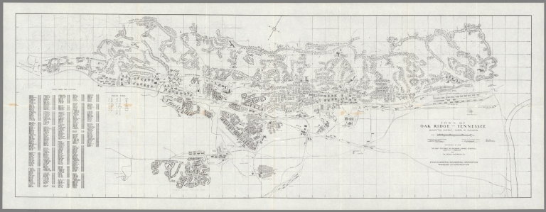
Skidmore, Owings & Merrill
Full Title
Town of Oak Ridge, Tennessee, Manhattan District, Corps of Engineers.
List No
15186.000
Author
Reichsamt fur Landesaufnahme
Full Title
(Covers to) Übersichtskarte der Übergänge im Stromgebiet der Oder und der Küstenflüsse in Pommern in 6 Teilen [Overview map of the crossings in the Oder river basin and the coastal rivers in Pomerania in 6 parts]
List No
15211.001
Author
Reichsamt fur Landesaufnahme
Full Title
Teil I Übersichtskarte der Übergänge im Stromgebiet der Oder und der Küstenflüsse in Pommern in 6 Teilen. Abgeschlossen 1. September 1938.
List No
15211.002
Author
Reichsamt fur Landesaufnahme
Full Title
Teil II Übersichtskarte der Übergänge im Stromgebiet der Oder und der Küstenflüsse in Pommern in 6 Teilen. Abgeschlossen 1. September 1938.
List No
15211.003
|


![Magyarorszag Légihelyzet Nyilvántartó Térképe [Air Situation Register Map of Hungary]](https://www.davidrumsey.com/rumsey/Size2/RUMSEY~8~1/199/15295000.jpg)
![Covers: Übersichtskarte der Übergänge im Stromgebiet der Oder und der Küstenflüsse in Pommern in 6 Teilen [Overview map of the crossings in the Oder river basin and the coastal rivers in Pomerania in 6 parts]](https://www.davidrumsey.com/rumsey/Size2/RUMSEY~8~1/199/15211001.jpg)

