|
Author
Spielmann and Brush
Full Title
Map of a tract of land commonly called the Hermitage : Situated in the ninth ward of the City of New York ... Compiled from authentic surveys February 1825 by Daniel Eiven City Surveyor. Published by Spielmann & Brush, civil engineers, Hoboken, N.J. 1881. Copied in the Registrer's Office January 2nd. 1873. (to accompany) Certified copies of original maps of property in New York City.
List No
13338.011
Note
Hand colored cadastral map. Includes notes and names of adjoining landholders. "Showing the same a subdivided into lots on the intersecting avenues and streets". Oriented with north to the upper center.
Author
Spielmann and Brush
Full Title
Map of property belonging o S. Benson and B. Vredenbergh, Decd. in the Twelfth Ward of the City of New York. Copied in the Registrer's Office, City of New York; Dec. 20nd. 1872. Published by Spielmann & Brush, civil engineers, Hoboken, N.J. 1881. (to accompany) Certified copies of original maps of property in New York City.
List No
13338.012
Note
Hand colored cadastral map. Includes notes and names of adjoining landholders. Oriented with north to the upper left.
Author
Spielmann and Brush
Full Title
3d. Ave. Tract. Published by Spielmann & Brush, civil engineers, Hoboken, N.J. 1881. (to accompany) Certified copies of original maps of property in New York City.
List No
13338.013
Note
Hand colored cadastral map on 2 sheets. Includes notes and names of adjoining landholders. Oriented with north to the upper right.
Author
Spielmann and Brush
Full Title
Map of third Avenue Tract, fromer property of B. P. Benson and Doctor P. Van Arsdale. Surveyed Sept. 1825 by J. F. Bridges, New York. Published by Spielmann & Brush, civil engineers, Hoboken, N.J. 1881. (to accompany) Certified copies of original maps of property in New York City.
List No
13338.014
Note
Hand colored cadastral map on 2 sheets. Includes notes and names of adjoining landholders. Oriented with north to the upper right.
Author
Spielmann and Brush
Full Title
(Composite Map) Map of third Avenue Tract, fromer property of B. P. Benson and Doctor P. Van Arsdale. Surveyed Sept. 1825 by J. F. Bridges, New York. Published by Spielmann & Brush, civil engineers, Hoboken, N.J. 1881. (to accompany) Certified copies of original maps of property in New York City.
List No
13338.015
Note
Composite map of sheets 9-12: Third Avenue Tract.
Author
Spielmann and Brush
Full Title
Map of a part of Louvre Farm, for an exchange of land. New York, Feby, 29 1860. Herring Farm. New York July 29th. 1828 Geo. B. Smith, City Surveyor. Published by Spielmann & Brush, civil engineers, Hoboken, N.J. 1881. (to accompany) Certified copies of original maps of property in New York City.
List No
13338.016
Note
2 hand colored cadastral maps on 1 sheet. Includes notes.
Author
Spielmann and Brush
Full Title
Map of lot 4 of the Louvre Farm. New York, July 1855. Surveyed by Gardner A. Sage, City Surveyor. Published by Spielmann & Brush, civil engineers, Hoboken, N.J. 1881. (to accompany) Certified copies of original maps of property in New York City.
List No
13338.017
Note
Hand colored cadastral map. Includes notes. Oriented with north to the right.
Author
Spielmann and Brush
Full Title
Map of lands in the 12th. Ward of the City of New York commonly known as the Strikers Bay Farm. New York, December 1855. John J. Serrell, City Surveyor. Published by Spielmann & Brush, civil engineers, Hoboken, N.J. 1881. (to accompany) Certified copies of original maps of property in New York City.
List No
13338.018
Note
Hand colored cadastral map. Includes notes. Oriented with north to the upper left.
Author
Spielmann and Brush
Full Title
Map of the Glass House Farm : belonging to George Rapel Je Esq. Situated in the T'welfth Ward of the City of New York. New York, 1833. Surveyed by Dan'l Ewen, City Surveyor. Published by Spielmann & Brush, civil engineers, Hoboken, N.J. 1881. (to accompany) Certified copies of original maps of property in New York City.
List No
13338.019
Note
Hand colored cadastral map on 2 sheets. Continues on pages 21-22. Includes notes. Oriented with north to the upper left.
Author
Spielmann and Brush
Full Title
Map of the Glass House Farm : belonging to George Rapelje Esq. Situated in the T'welfth Ward of the City of New York. New York, 1833. Surveyed by Dan'l Ewen, City Surveyor. Published by Spielmann & Brush, civil engineers, Hoboken, N.J. 1881. (to accompany) Certified copies of original maps of property in New York City.
List No
13338.020
Note
Continues: Hand colored cadastral map on 2 sheets. Includes notes. Oriented with north to the upper left.
Author
Spielmann and Brush
Full Title
(Composite Map) Map of the Glass House Farm : belonging to George Rapelje Esq. Situated in the T'welfth Ward of the City of New York. New York, 1833. Surveyed by Dan'l Ewen, City Surveyor. Published by Spielmann & Brush, civil engineers, Hoboken, N.J. 1881. (to accompany) Certified copies of original maps of property in New York City.
List No
13338.021
Note
Composite map of sheet 19-22: Glass House Farm.
Author
Spielmann and Brush
Full Title
Map of land in the 12th. ward of the City of New-York belonging to the estate of George C. Schroepel decd. Surveyed & laid out into lots, September 15th. 1830, by Geo. B. Smith, City Surveyor. Published by Spielmann & Brush, civil engineers, Hoboken, N.J. 1881. (to accompany) Certified copies of original maps of property in New York City.
List No
13338.022
Note
Hand colored cadastral map. Includes notes. Oriented with north to the upper right.
Author
Spielmann and Brush
Full Title
Map of lands in the 12th Ward of the City of New York belonging to the estate of Cornelius Ray, decd. Surveyed & laid out by Edwin Smith, City Surveyor, New York, Feb. 11th., 1834. Published by Spielmann & Brush, civil engineers, Hoboken, N.J. 1881. (to accompany) Certified copies of original maps of property in New York City.
List No
13338.023
Note
Continues by pages 27-28. Hand colored cadastral map. Includes notes and list of adjoining landholders.
Author
Spielmann and Brush
Full Title
Map of lands in the 12th Ward of the City of New York belonging to the estate of Cornelius Ray, decd. Surveyed & laid out by Edwin Smith, City Surveyor, New York, Feb. 11th., 1834. Published by Spielmann & Brush, civil engineers, Hoboken, N.J. 1881. (to accompany) Certified copies of original maps of property in New York City.
List No
13338.024
Note
Continued pages 25-26. Hand colored cadastral map. Includes notes and list of adjoining landholders.
Author
Spielmann and Brush
Full Title
(Composite Map) Map of lands in the 12th Ward of the City of New York belonging to the estate of Cornelius Ray, decd. Surveyed & laid out by Edwin Smith, City Surveyor, New York, Feb. 11th., 1834. Published by Spielmann & Brush, civil engineers, Hoboken, N.J. 1881. (to accompany) Certified copies of original maps of property in New York City.
List No
13338.025
Note
Composite of Pages 25-28: Lands in the 12th Ward of the City of New York belonging to the estate of Cornelius Ray.
Author
Spielmann and Brush
Full Title
Map of Delancy's Farm : Western part. copied in the Register's Office, January 26th. 1873 from copy certified by G. E. Smith, City Surveyor. Published by Spielmann & Brush, civil engineers, Hoboken, N.J. 1881. (to accompany) Certified copies of original maps of property in New York City.
List No
13338.026
Note
Hand colored cadastral map of West part of De Lancy's Farm, Continued by pages 31-32. Includes notes. Oriented with north to the upper left. Includes a separate maps and list of "Purchasers of the DeLancey's Farm".
Author
Spielmann and Brush
Full Title
Map of Delancy's Farm : Western part. copied in the Register's Office, January 26th. 1873 from copy certified by G. E. Smith, City Surveyor. Published by Spielmann & Brush, civil engineers, Hoboken, N.J. 1881. (to accompany) Certified copies of original maps of property in New York City.
List No
13338.027
Note
Hand colored cadastral map of West part of De Lancy's Farm. Continues pages 29-30. Includes notes. Oriented with north to the upper left. Includes a separate map and list of "Purchasers of the DeLancey's Farm".
Author
Spielmann and Brush
Full Title
(Composite Map) Map of Delancy's Farm : Western part. copied in the Register's Office, January 26th. 1873 from copy certified by G. E. Smith, City Surveyor. Published by Spielmann & Brush, civil engineers, Hoboken, N.J. 1881. (to accompany) Certified copies of original maps of property in New York City.
List No
13338.028
Note
Composite of Pages 29-32: West part of De Lancy's Farm.
Author
Spielmann and Brush
Full Title
Map of Delancy's Farm : Western part. copied in the Register's Office, January 26th. 1873 from copy certified by G. E. Smith, City Surveyor. Published by Spielmann & Brush, civil engineers, Hoboken, N.J. 1881. (to accompany) Certified copies of original maps of property in New York City.
List No
13338.029
Note
Supplement to map of Delancy's Farm. Includes map and list of Purchasers.
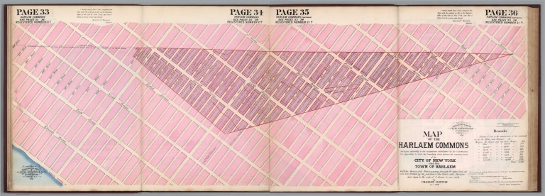
Author
Spielmann and Brush
Full Title
Map of the Harlaem Commons : surveyed agreeably to the boundaries established by the Commissioners appointed to settle the boundary lines between the common lands of the City of New York and the Town of Harlaem ... By Charles Clinton Decr. 1824. Published by Spielmann & Brush, civil engineers, Hoboken, N.J. 1881. (to accompany) Certified copies of original maps of property in New York City.
List No
13338.030
Note
Hand colored cadastral map of West part of Harlaem. Based on an original survey by Charles Clinton completed in December 1824.
Author
Spielmann and Brush
Full Title
Map of the Harlaem Commons : surveyed agreeably to the boundaries established by the Commissioners appointed to settle the boundary lines between the common lands of the City of New York and the Town of Harlaem ... By Charles Clinton Decr. 1824. Published by Spielmann & Brush, civil engineers, Hoboken, N.J. 1881. (to accompany) Certified copies of original maps of property in New York City.
List No
13338.031
Note
Hand colored cadastral map of East part of Harlaem. Based on an original survey by Charles Clinton completed in December 1824. Includes notes and remarks.
Author
Spielmann and Brush
Full Title
(Composite Map) Map of the Harlaem Commons : surveyed agreeably to the boundaries established by the Commissioners appointed to settle the boundary lines between the common lands of the City of New York and the Town of Harlaem ... By Charles Clinton Decr. 1824. Published by Spielmann & Brush, civil engineers, Hoboken, N.J. 1881. (to accompany) Certified copies of original maps of property in New York City.
List No
13338.032
Note
Composite of pages 33-36: Harlaem Commons.
Author
Spielmann and Brush
Full Title
Map of Delancy's Farm : Eastern part. Copied from the map in the Street Commissioners Office, New York Aug. 9th. 1831, Geo. B. Smith. Published by Spielmann & Brush, civil engineers, Hoboken, N.J. 1881. (to accompany) Certified copies of original maps of property in New York City.
List No
13338.033
Note
Hand colored cadastral map of East part of De Lancy's Farm. Includes a separate map and list of "Purchasers of the DeLancey's Farm".
Author
Spielmann and Brush
Full Title
Map of Delancy's Farm : Eastern part. Copied from the map in the Street Commissioners Office, New York Aug. 9th. 1831, Geo. B. Smith. Published by Spielmann & Brush, civil engineers, Hoboken, N.J. 1881. (to accompany) Certified copies of original maps of property in New York City.
List No
13338.034
Note
Supplement to map of Delancy's Farm. Includes map and list of Purchasers.
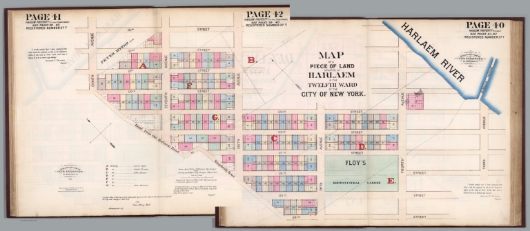
Author
Spielmann and Brush
Full Title
Map of the piece of land situated at Harlaem in the Twelfth Ward of the City of New York. Drawn April 1827 by J. F. Bridges, City Surveyor ... Copied in the Registers Office ... April 1st. 1872. Published by Spielmann & Brush, civil engineers, Hoboken, N.J. 1881. (to accompany) Certified copies of original maps of property in New York City.
List No
13338.035
Note
Hand colored cadastral map. Includes notes. Oriented with north to the upper left.
Author
Spielmann and Brush
Full Title
Map of the piece of land situated at Harlaem in the Twelfth Ward of the City of New York. Drawn April 1827 by J. F. Bridges, City Surveyor ... Copied in the Registers Office ... April 1st. 1872. Published by Spielmann & Brush, civil engineers, Hoboken, N.J. 1881. (to accompany) Certified copies of original maps of property in New York City.
List No
13338.036
Note
Hand colored cadastral map. Includes notes. Oriented with north to the upper left.
Author
Spielmann and Brush
Full Title
(Composite Map) Map of the piece of land situated at Harlaem in the Twelfth Ward of the City of New York. Drawn April 1827 by J. F. Bridges, City Surveyor ... Copied in the Registers Office ... April 1st. 1872. Published by Spielmann & Brush, civil engineers, Hoboken, N.J. 1881. (to accompany) Certified copies of original maps of property in New York City.
List No
13338.037
Note
Composite of pages 39-42: Harlem property.
Author
Spielmann and Brush
Full Title
Map of land in the 16th Ward of the City of New York belonging to the heirs of John Murray. New York Feby. 15th. 1873 Surveyed by Edwin Smith, City Surveyor. Published by Spielmann & Brush, civil engineers, Hoboken, N.J. 1881. (to accompany) Certified copies of original maps of property in New York City.
List No
13338.038
Note
Hand colored cadastral map. Includes notes. Oriented with north to the upper right.
Author
Spielmann and Brush
Full Title
Map of property belonging to E. Wiswall and F. Price and formerly to J. Quackembush. Surveyed by Joseph F. Bridges, July 1825. Published by Spielmann & Brush, civil engineers, Hoboken, N.J. 1881. (to accompany) Certified copies of original maps of property in New York City.
List No
13338.039
Note
Hand colored cadastral map. Includes notes. Oriented with north to the upper left.
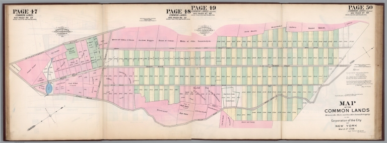
Author
Spielmann and Brush
Full Title
Map of the Common Lands between the three and six mile stones belonging to the Corporation of the City of New York March 1st. 1796. (Sig) Casimir Ph. Goerck, City Surveyor. Published by Spielmann & Brush, civil engineers, Hoboken, N.J. 1881. (to accompany) Certified copies of original maps of property in New York City.
List No
13338.040
Note
Hand colored cadastral map. Includes notes. Oriented with north to the right.
Author
Spielmann and Brush
Full Title
Map of the Common Lands between the three and six mile stones belonging to the Corporation of the City of New York March 1st. 1796. (Sig) Casimir Ph. Goerck, City Surveyor. Published by Spielmann & Brush, civil engineers, Hoboken, N.J. 1881. (to accompany) Certified copies of original maps of property in New York City.
List No
13338.041
Note
Hand colored cadastral map. Includes notes. Oriented with north to the right.
Author
Spielmann and Brush
Full Title
(Composite Map) Map of the Common Lands between the three and six mile stones belonging to the Corporation of the City of New York March 1st. 1796. (Sig) Casimir Ph. Goerck, City Surveyor. Published by Spielmann & Brush, civil engineers, Hoboken, N.J. 1881. (to accompany) Certified copies of original maps of property in New York City.
List No
13338.042
Note
Composite of pages 47-50: Common Lands.
Author
Spielmann and Brush
Full Title
Map of 547 lots in the 12th Ward of the City of New York belonging to John H. Dyckman. New York Janyary 10th. 1860 Andrew Findlay, Surveyor. Published by Spielmann & Brush, civil engineers, Hoboken, N.J. 1881. (to accompany) Certified copies of original maps of property in New York City.
List No
13338.043
Note
Hand colored cadastral map. Includes notes. Oriented with north to the upper left.
Author
Spielmann and Brush
Full Title
Map of residuary Real Estate of Peter Gerard Stuyvesant Decd. City of New York ... Register October 24th. 1848. Published by Spielmann & Brush, civil engineers, Hoboken, N.J. 1881. (to accompany) Certified copies of original maps of property in New York City.
List No
13338.044
Note
Hand colored cadastral map. Includes 6 insets and notes. Oriented with north to the upper left.
Author
Spielmann and Brush
Full Title
Cornelius Ray Decd. New York, November 19 1844 Gardner A. Sage, City Surveyor. Published by Spielmann & Brush, civil engineers, Hoboken, N.J. 1881. (to accompany) Certified copies of original maps of property in New York City.
List No
13338.045
Note
Hand colored cadastral map. Includes notes. Oriented with north to the upper left.
Author
Spielmann and Brush
Full Title
Map of lands in the Twelfth Ward of the City of New York, belonging to the Estate of the late Mrs. Ann Rogers, Decd. New York, November 17th. 1834. Surveyed and laid out by Edwin Smith, City Surveyor. Published by Spielmann & Brush, civil engineers, Hoboken, N.J. 1881. (to accompany) Certified copies of original maps of property in New York City.
List No
13338.046
Note
Hand colored cadastral map. Includes notes. Oriented with north to the upper left.
Author
Spielmann and Brush
Full Title
Map of lands in the Twelfth Ward of the City of New York, belonging to the Estate of the late Mrs. Ann Rogers, Decd. New York, November 17th. 1834. Surveyed and laid out by Edwin Smith, City Surveyor. Published by Spielmann & Brush, civil engineers, Hoboken, N.J. 1881. (to accompany) Certified copies of original maps of property in New York City.
List No
13338.047
Note
Hand colored cadastral map. Includes notes. Oriented with north to the upper left.
Author
Spielmann and Brush
Full Title
(Composite Map) Map of lands in the Twelfth Ward of the City of New York, belonging to the Estate of the late Mrs. Ann Rogers, Decd. New York, November 17th. 1834. Surveyed and laid out by Edwin Smith, City Surveyor. Published by Spielmann & Brush, civil engineers, Hoboken, N.J. 1881. (to accompany) Certified copies of original maps of property in New York City.
List No
13338.048
Note
Composite map of of pages 57-60: Ann Rogers Decd.
Author
Spielmann and Brush
Full Title
Leandert Farm. New York April 1827, Drawn by Thos. R. Ludlam, City Surveyor. Published by Spielmann & Brush, civil engineers, Hoboken, N.J. 1881. (to accompany) Certified copies of original maps of property in New York City.
List No
13338.049
Note
Hand colored cadastral map. Includes notes. Oriented with north to the lower left. Includes color coded list of the landowners.
Author
Spielmann and Brush
Full Title
Leandert Farm. New York April 1827, Drawn by Thos. R. Ludlam, City Surveyor. Published by Spielmann & Brush, civil engineers, Hoboken, N.J. 1881. (to accompany) Certified copies of original maps of property in New York City.
List No
13338.050
Note
Hand colored cadastral map. Includes notes. Oriented with north to the lower left. Includes color coded list of the landowners.
Author
Spielmann and Brush
Full Title
(Composite Map) Leandert Farm. New York April 1827, Drawn by Thos. R. Ludlam, City Surveyor. Published by Spielmann & Brush, civil engineers, Hoboken, N.J. 1881. (to accompany) Certified copies of original maps of property in New York City.
List No
13338.051
Note
Composite map of pages 61-64: Leandert Farm.
Author
Spielmann and Brush
Full Title
Map of the Baker Estate ... New York May 14th. 1852. Published by Spielmann & Brush, civil engineers, Hoboken, N.J. 1881. (to accompany) Certified copies of original maps of property in New York City.
List No
13338.052
Note
Hand colored cadastral map. Includes notes.
Author
Spielmann and Brush
Full Title
Isaac Lawrence & Wm. Astors property 1840. Published by Spielmann & Brush, civil engineers, Hoboken, N.J. 1881. (to accompany) Certified copies of original maps of property in New York City.
List No
13338.053
Note
Hand colored cadastral map. Includes notes.
Author
Spielmann and Brush
Full Title
Map of Mount Vernon. New York : Surveyed September 5, 1826. by Edward Doughty, City Surveyor. Published by Spielmann & Brush, civil engineers, Hoboken, N.J. 1881. (to accompany) Certified copies of original maps of property in New York City.
List No
13338.054
Note
Hand colored cadastral map. Shows part of East River. Includes notes and decorative compass rose oriented with north to the upper center. Includes a supplement map of: The East River. A map of a Farm belonging to Mr. Robinson ...
Author
Spielmann and Brush
Full Title
Map of Mount Vernon. New York : Surveyed September 5, 1826. by Edward Doughty, City Surveyor. Published by Spielmann & Brush, civil engineers, Hoboken, N.J. 1881. (to accompany) Certified copies of original maps of property in New York City.
List No
13338.055
Note
Supplement to the pages 67-68. Mount Vernon. Registered number 58. The East River. A map of a Farm belonging to Mr. Robinson ...
Author
Spielmann and Brush
Full Title
Map of the property of William Wood situated in the Town of Harlem. New York August 19th. 1828, Edward Doughty, City Surveyor. Published by Spielmann & Brush, civil engineers, Hoboken, N.J. 1881. (to accompany) Certified copies of original maps of property in New York City.6
List No
13338.056
Note
Hand colored cadastral map. Includes notes and decorative compass rose oriented with north to the upper center.
Author
Spielmann and Brush
Full Title
Map of the first division of the estate of Saml. I. L. Norton Decd. situated in the 9th. Ward of the City of New York : Surveyed and laid into lots for Henry Lynch October 1824 by Daniel Ewen City Surveyor. Published by Spielmann & Brush, civil engineers, Hoboken, N.J. 1881. (to accompany) Certified copies of original maps of property in New York City.6
List No
13338.057
Note
Hand colored cadastral map. Includes notes and decorative compass rose oriented with north to the upper right.
Author
Spielmann and Brush
Full Title
Map of subdivision No. 3 of Saml. I. L. Norton Decd. Shewing the same as laid and in lots. Published by Spielmann & Brush, civil engineers, Hoboken, N.J. 1881. (to accompany) Certified copies of original maps of property in New York City.
List No
13338.058
Note
Hand colored cadastral map. Includes notes and decorative compass rose oriented with north to the upper center.
Author
Spielmann and Brush
Full Title
Jas. L. Curtis : Registered number 240. New York June 28th 1838, Joseph F. Bridges, City Surveyor. Published by Spielmann & Brush, civil engineers, Hoboken, N.J. 1881. (to accompany) Certified copies of original maps of property in New York City.
List No
13338.059
Note
Hand colored cadastral map. Includes notes and decorative compass rose oriented with north to the right.
Author
Spielmann and Brush
Full Title
Jas. L. Curtis : Registered number 261. Published by Spielmann & Brush, civil engineers, Hoboken, N.J. 1881. (to accompany) Certified copies of original maps of property in New York City.
List No
13338.060
Note
Hand colored cadastral map. Includes notes and decorative compass rose oriented with north to the upper left.
|