|
Author
[Iran Oil Exploration and Production Joint Stock Company, Aero Service Corporation]
Full Title
ایران (Iran) شرکتهای عامل نفت ایران (Iranian Oil Companies) شرکت سهامی اکتشاف و تولید نفت ایران، شرکت سهامی تصفیه نفت ایران) با همکاری شرکت ملی نفت ایران و سازمان نقشه برداری کل (Iran Oil Exploration and Production Joint Stock Company, Iran Oil Refining Joint Stock Company in cooperation with the National Iranian Oil Company and the Mapping Organization of the whole country)
List No
15736.000
Note
3D Plastic relief map. Date estimated.
Author
Lisle, Brian Orchard
Full Title
GSI... marine seismic leader, 23,000 miles of marine seismic traverse shot in 1961. Geophysical Service International ...
List No
14285.003
Note
Colored map of Australasia representing oil resources. Shows national and state boundaries, oil fields, gas fields, refineries, pipelines, railroads, drainage, coastline, islands, and continental shelf. Includes latitudinal and longitudinal markers along perimeter, as well as a legend, two bar scales (in miles and kilometers) and compass roses. Features illustrations throughout, such as of a kangaroo and a kiwi bird. Lists: Owners of concessions, leases & permits. With tables of data, such as: Australasian field operations & proven reserves. Also, with seven inset maps: Carnarvon Basin; one-well field & shows -- Southern Victoria : Gippsland Basin finds -- Lakes Entrance : Shallow stripper yields -- Sydney : Some gas flows -- S. E. Melanesia -- Great Artesian Basin discoveries : Old Permian Shoreline Trend, Queensland -- New Zealand. Map is 94 x 122 cm, on sheet 97 x 127 cm, folded to 30 x 23 cm.
Author
Von Der Nonne, Nikolaus [Nikolai] Augustovich
Full Title
Plan sushestvuyushago i proektirovannago ragpolojenia gubernskago goroda Baku, c' ponazaniem'..., 1898-1900 g. [i.e. Plan of the existing and projected location of Baku]
List No
15269.000
Author
[Smith, Elmer, Wolfson, W.M.]
Full Title
Standard Oil (N.J.): An Expanding Universe.
List No
15247.000
Note
Date estimated.
Author
Union Des Chambres Syndicales De L'Industrie Du Petrole
Full Title
Le Petrole Dans Le Monde
List No
15106.000
Author
Geological Survey (U.S.)
Full Title
Oil production and reserves : 1966 -- Natural gas production and reserves : 1966 -- Natural gas liquids production and reserves : 1966 -- Coal production and reserves, anthracite, bituminous, and lignite : 1966 / compiled by U. S. Geologic Survey, 1968 -- Oil shale and tar sands : 1965 -- Nuclear materials : 1967 -- Organic fuels, production and consumption : Total petroleum production, billion barrels of crude oil equivalent -- Oil production, billion barrels -- Gas production, trillion cubic feet -- Coal production, million short tons -- Oil consumption -- Gas consumption -- Coal consumption.
List No
14359.136
Note
Six mineral maps and seven charts representing the United States, featuring the geographic locations of energy materials - such as oil, natural gas and coal - as of 1967. Maps show the production and reserves of energy materials, as well as political boundaries, bodies of water, coastlines and islands. Maps include legends, as well as bar scales and scale statements. Presented with Albers Equal Area Projection. With two inset maps within each map: Principal islands of Hawaii -- Alaska. Charts show production and consumption. Colored lithograph. Together, maps and charts are 42 x 31 cm, on sheet 49 x 35 cm. Accompanying descriptive text on page 177. Maps and charts appear in Special subject maps section, subsection Economic : Mineral and energy resources.
Author
[Wichita Mapping Engineering Co., Hannaford and Gardner]
Full Title
Index map : Marion County oil fields. Hannaford and Gardner - abstracters, exclusive sales agents. Marion, Kansas.
List No
14342.002
Note
Index map to Township maps of Marion County oil fields, by the Wichita Mapping Engineering Co. Shows producing oil wells, gas wells, light oil wells, dry holes and drilling sites, as well as railroads and rivers. Lists land and lease owners of plots. Sectioned according to township and range. Includes a legend and compass rose, with north oriented toward top of sheet. Map is 27 x 22 cm, on sheet 39 x 35 cm. Blueprint, with text and graphics in white. Index map precedes 17 maps in atlas.
Author
[Wichita Mapping Engineering Co., Hannaford and Gardner]
Full Title
Marion County oil fields : 1.
List No
14342.003
Note
Map "1" in series of 17 maps entitled Marion County oil fields. Shows producing oil wells, gas wells, light oil wells, dry holes and drilling sites, as well as railroads and rivers. Lists land and lease owners of plots. Sectioned according to township and range. Series preceded by Index map, which includes a legend corresponding to all maps in the series. Map is 31 x 31 cm, on sheet 39 x 35 cm. Blueprint, with text and graphics in white.
Author
[Wichita Mapping Engineering Co., Hannaford and Gardner]
Full Title
Marion County oil fields : 2.
List No
14342.004
Note
Map "2" in series of 17 maps entitled Marion County oil fields. Shows producing oil wells, gas wells, light oil wells, dry holes and drilling sites, as well as railroads and rivers. Lists land and lease owners of plots. Sectioned according to township and range. Series preceded by Index map, which includes a legend corresponding to all maps in the series. Map is 31 x 31 cm, on sheet 39 x 35 cm. Blueprint, with text and graphics in white.
Author
[Wichita Mapping Engineering Co., Hannaford and Gardner]
Full Title
Marion County oil fields : 7.
List No
14342.005
Note
Map "7" in series of 17 maps entitled Marion County oil fields. Shows producing oil wells, gas wells, light oil wells, dry holes and drilling sites, as well as railroads and rivers. Lists land and lease owners of plots. Sectioned according to township and range. Series preceded by Index map, which includes a legend corresponding to all maps in the series. Map is 31 x 31 cm, on sheet 39 x 35 cm. Blueprint, with text and graphics in white.
Author
[Wichita Mapping Engineering Co., Hannaford and Gardner]
Full Title
Marion County oil fields : 8.
List No
14342.006
Note
Map "8" in series of 17 maps entitled Marion County oil fields. Shows producing oil wells, gas wells, light oil wells, dry holes and drilling sites, as well as railroads and rivers. Lists land and lease owners of plots. Sectioned according to township and range. Series preceded by Index map, which includes a legend corresponding to all maps in the series. Map is 31 x 31 cm, on sheet 39 x 35 cm. Blueprint, with text and graphics in white.
Author
[Wichita Mapping Engineering Co., Hannaford and Gardner]
Full Title
Marion County oil fields : 9.
List No
14342.007
Note
Map "9" in series of 17 maps entitled Marion County oil fields. Shows producing oil wells, gas wells, light oil wells, dry holes and drilling sites, as well as railroads and rivers. Lists land and lease owners of plots. Sectioned according to township and range. Series preceded by Index map, which includes a legend corresponding to all maps in the series. Map is 31 x 31 cm, on sheet 39 x 35 cm. Blueprint, with text and graphics in white.
Author
[Wichita Mapping Engineering Co., Hannaford and Gardner]
Full Title
Marion County oil fields : 10.
List No
14342.008
Note
Map "10" in series of 17 maps entitled Marion County oil fields. Shows producing oil wells, gas wells, light oil wells, dry holes and drilling sites, as well as railroads and rivers. Lists land and lease owners of plots. Sectioned according to township and range. Series preceded by Index map, which includes a legend corresponding to all maps in the series. Map is 31 x 31 cm, on sheet 39 x 35 cm. Blueprint, with text and graphics in white.
Author
[Wichita Mapping Engineering Co., Hannaford and Gardner]
Full Title
Marion County oil fields : 11.
List No
14342.009
Note
Map "11" in series of 17 maps entitled Marion County oil fields. Shows producing oil wells, gas wells, light oil wells, dry holes and drilling sites, as well as railroads and rivers. Lists land and lease owners of plots. Sectioned according to township and range. Series preceded by Index map, which includes a legend corresponding to all maps in the series. Map is 31 x 31 cm, on sheet 39 x 35 cm. Blueprint, with text and graphics in white.
Author
[Wichita Mapping Engineering Co., Hannaford and Gardner]
Full Title
Marion County oil fields : 12.
List No
14342.010
Note
Map "12" in series of 17 maps entitled Marion County oil fields. Shows producing oil wells, gas wells, light oil wells, dry holes and drilling sites, as well as railroads and rivers. Lists land and lease owners of plots. Sectioned according to township and range. Series preceded by Index map, which includes a legend corresponding to all maps in the series. Map is 31 x 31 cm, on sheet 39 x 35 cm. Blueprint, with text and graphics in white.
Author
[Gorkin, Aleksandr Fedorovich, Motylev, V.E.]
Full Title
Toplivnaia, rudnaia, metallurgicheskaia i khimicheskaia promyshlennost Evropeiskoi chasti Soiuza SSR. (inset) Donbass. (to accompany) Bolshoi Sovietskii Atlas Mira. Moskva 1937.
List No
11008.144
Note
Color maps with inset on 2 sheets. Showing fuel, ore, metallurgical and chemical industries in European Russia. Include explanation to symbols, statistical charts and graphs. Shows oil and gas fields, pipelines, refineries, coal-producing areas, etc.
Author
Sundberg, Edwin L.
Full Title
Oil, the Target of the Axis. July 26, 1942.
List No
12259.000
Author
Beers, F. W. (Frederick W.)
Full Title
(Covers to) Atlas of the oil region of Pennsylvania. From actual surveys under the direction of F.W. Beers, C.E. Assisted by Beach Nichols, J.M. Beers, A. Leavenworth, C.S. Peck, C.A. Curtis & Geo. Stewart. With a few facts relating to petroleum, historically, scientifically, and commercially, reviewed by Ivan C. Michels, Editor of the Philadelphia Coal Oil Circular and Petroleum Price Current. Published by F.W. Beers, A.D. Ellis & G.G. Soule, 43 John St. N.Y. Assistants: W.H. Hubbell, Willard Upton. Assistants: S. Stewart, Jas. Rhynus. Entered ... 1865 ... New York by F.W. Beers & Co. Ferd. Mayer & Co. Lithographers, 96 Fulton St. N.Y.
List No
0062A
Note
The only regional atlas made of the oil regions in Pennsylvania and probably the most complete and detailed mapping done at the time -- it is far more detailed than the general maps that appeared in pocket form or separately -- Colton, Townsend and Dale, Hunt, Howe, and Root, Anthony (see our copies). With the large Venango County map, as issued. Maps hand col. Atlas is rebound in new speckled paper covered boards with quarter faux leather spine and original cover label pasted on the front reading "Beers & Co.'s Atlas of the oil regions. Price $12.50" in gold print. Pages 5-6 listed in contents but lacking in this copy.
Author
Beers, F. W. (Frederick W.)
Full Title
(Title Page to) Atlas of the oil region of Pennsylvania. From actual surveys under the direction of F.W. Beers, C.E. Assisted by Beach Nichols, J.M. Beers, A. Leavenworth, C.S. Peck, C.A. Curtis & Geo. Stewart. With a few facts relating to petroleum, historically, scientifically, and commercially, reviewed by Ivan C. Michels, Editor of the Philadelphia Coal Oil Circular and Petroleum Price Current. Published by F.W. Beers, A.D. Ellis & G.G. Soule, 43 John St. N.Y. Assistants: W.H. Hubbell, Willard Upton. Assistants: S. Stewart, Jas. Rhynus. Entered ... 1865 ... New York by F.W. Beers & Co. Ferd. Mayer & Co. Lithographers, 96 Fulton St. N.Y.
List No
0062B
Note
The only regional atlas made of the oil regions in Pennsylvania and probably the most complete and detailed mapping done at the time -- it is far more detailed than the general maps that appeared in pocket form or separately -- Colton, Townsend and Dale, Hunt, Howe, and Root, Anthony (see our copies). With the large Venango County map, as issued. Maps hand col. Atlas is rebound in new speckled paper covered boards with quarter faux leather spine and original cover label pasted on the front reading "Beers & Co.'s Atlas of the oil regions. Price $12.50" in gold print. Pages 5-6 listed in contents but lacking in this copy.
Author
[Beers, F. W. (Frederick W.), F.W. Beers & Co.]
Full Title
Outline map of Venango Co., Pa. from actual surveys. Published by F.W. Beers & Co., 43 John St., New York. 1865. Entered ... 1865 ... Southern District of New York by F.W. Beers & Co. Ferd. Mayer & Co. Lithographers, 96 Fulton St., N.Y.
List No
0062.001
Note
Hand col. lithographed map. Shows townships, refineries, mills, foundries, etc.
Author
Beers, F. W. (Frederick W.)
Full Title
(Contents to) Atlas of the oil region of Pennsylvania. From actual surveys under the direction of F.W. Beers, C.E. Assisted by Beach Nichols, J.M. Beers, A. Leavenworth, C.S. Peck, C.A. Curtis & Geo. Stewart. With a few facts relating to petroleum, historically, scientifically, and commercially, reviewed by Ivan C. Michels, Editor of the Philadelphia Coal Oil Circular and Petroleum Price Current. Published by F.W. Beers, A.D. Ellis & G.G. Soule, 43 John St. N.Y. Assistants: W.H. Hubbell, Willard Upton. Assistants: S. Stewart, Jas. Rhynus. Entered ... 1865 ... New York by F.W. Beers & Co. Ferd. Mayer & Co. Lithographers, 96 Fulton St. N.Y.
List No
0062C
Note
The only regional atlas made of the oil regions in Pennsylvania and probably the most complete and detailed mapping done at the time -- it is far more detailed than the general maps that appeared in pocket form or separately -- Colton, Townsend and Dale, Hunt, Howe, and Root, Anthony (see our copies). With the large Venango County map, as issued. Maps hand col. Atlas is rebound in new speckled paper covered boards with quarter faux leather spine and original cover label pasted on the front reading "Beers & Co.'s Atlas of the oil regions. Price $12.50" in gold print. Pages 5-6 listed in contents but lacking in this copy.
Author
Beers, F. W. (Frederick W.)
Full Title
(Distance Table to) Atlas of the oil region of Pennsylvania. From actual surveys under the direction of F.W. Beers, C.E. Assisted by Beach Nichols, J.M. Beers, A. Leavenworth, C.S. Peck, C.A. Curtis & Geo. Stewart. With a few facts relating to petroleum, historically, scientifically, and commercially, reviewed by Ivan C. Michels, Editor of the Philadelphia Coal Oil Circular and Petroleum Price Current. Published by F.W. Beers, A.D. Ellis & G.G. Soule, 43 John St. N.Y. Assistants: W.H. Hubbell, Willard Upton. Assistants: S. Stewart, Jas. Rhynus. Entered ... 1865 ... New York by F.W. Beers & Co. Ferd. Mayer & Co. Lithographers, 96 Fulton St. N.Y.
List No
0062D
Note
Includes table of airline distances, and chart of airline distances from Franklin.
Author
Beers, F. W. (Frederick W.)
Full Title
(Text Page to) Atlas of the oil region of Pennsylvania. From actual surveys under the direction of F.W. Beers, C.E. Assisted by Beach Nichols, J.M. Beers, A. Leavenworth, C.S. Peck, C.A. Curtis & Geo. Stewart. With a few facts relating to petroleum, historically, scientifically, and commercially, reviewed by Ivan C. Michels, Editor of the Philadelphia Coal Oil Circular and Petroleum Price Current. Published by F.W. Beers, A.D. Ellis & G.G. Soule, 43 John St. N.Y. Assistants: W.H. Hubbell, Willard Upton. Assistants: S. Stewart, Jas. Rhynus. Entered ... 1865 ... New York by F.W. Beers & Co. Ferd. Mayer & Co. Lithographers, 96 Fulton St. N.Y.
List No
0062E
Author
Beers, F. W. (Frederick W.)
Full Title
(Text Page to) Atlas of the oil region of Pennsylvania. From actual surveys under the direction of F.W. Beers, C.E. Assisted by Beach Nichols, J.M. Beers, A. Leavenworth, C.S. Peck, C.A. Curtis & Geo. Stewart. With a few facts relating to petroleum, historically, scientifically, and commercially, reviewed by Ivan C. Michels, Editor of the Philadelphia Coal Oil Circular and Petroleum Price Current. Published by F.W. Beers, A.D. Ellis & G.G. Soule, 43 John St. N.Y. Assistants: W.H. Hubbell, Willard Upton. Assistants: S. Stewart, Jas. Rhynus. Entered ... 1865 ... New York by F.W. Beers & Co. Ferd. Mayer & Co. Lithographers, 96 Fulton St. N.Y.
List No
0062F
Author
Beers, F. W. (Frederick W.)
Full Title
(Text Page to) Atlas of the oil region of Pennsylvania. From actual surveys under the direction of F.W. Beers, C.E. Assisted by Beach Nichols, J.M. Beers, A. Leavenworth, C.S. Peck, C.A. Curtis & Geo. Stewart. With a few facts relating to petroleum, historically, scientifically, and commercially, reviewed by Ivan C. Michels, Editor of the Philadelphia Coal Oil Circular and Petroleum Price Current. Published by F.W. Beers, A.D. Ellis & G.G. Soule, 43 John St. N.Y. Assistants: W.H. Hubbell, Willard Upton. Assistants: S. Stewart, Jas. Rhynus. Entered ... 1865 ... New York by F.W. Beers & Co. Ferd. Mayer & Co. Lithographers, 96 Fulton St. N.Y.
List No
0062G
Note
Includes statistical table.
Author
Beers, F. W. (Frederick W.)
Full Title
(Text Page to) Atlas of the oil region of Pennsylvania. From actual surveys under the direction of F.W. Beers, C.E. Assisted by Beach Nichols, J.M. Beers, A. Leavenworth, C.S. Peck, C.A. Curtis & Geo. Stewart. With a few facts relating to petroleum, historically, scientifically, and commercially, reviewed by Ivan C. Michels, Editor of the Philadelphia Coal Oil Circular and Petroleum Price Current. Published by F.W. Beers, A.D. Ellis & G.G. Soule, 43 John St. N.Y. Assistants: W.H. Hubbell, Willard Upton. Assistants: S. Stewart, Jas. Rhynus. Entered ... 1865 ... New York by F.W. Beers & Co. Ferd. Mayer & Co. Lithographers, 96 Fulton St. N.Y.
List No
0062H
Note
Includes statistical tables.
Author
[Beers, F. W. (Frederick W.), F.W. Beers & Co.]
Full Title
Franklin. Entered ... 1865 ... Southern District of New York by F.W. Beers & Co. Ferd. Mayer & Co. Lithographers, 96 Fulton St., N.Y.
List No
0062.002
Note
Hand col. lithographed map. Shows lot numbers, buildings, refineries, etc. Includes business directory.
Author
[Beers, F. W. (Frederick W.), F.W. Beers & Co.]
Full Title
Plan of French Creek Township. (with) Utica. (with) Waterloo, Polk P.O. Entered ... 1865 ... Southern District of New York by F.W. Beers & Co. Ferd. Mayer & Co. Lithographers, 96 Fulton St., N.Y.
List No
0062.003
Note
Hand col. lithographed map. Shows landowners, quarries, etc. Includes business directories. Inset maps at (1:9,900) show buildings, owners, etc.
Author
[Beers, F. W. (Frederick W.), F.W. Beers & Co.]
Full Title
Plan of Sandy Creek Township. Entered ... 1865 ... Southern District of New York by F.W. Beers & Co. Ferd. Mayer & Co. Lithographers, 96 Fulton St., N.Y.
List No
0062.004
Note
Hand col. lithographed map. Shows landowners, etc.
Author
[Beers, F. W. (Frederick W.), F.W. Beers & Co.]
Full Title
Plan of Sugar Creek Township. Entered ... 1865 ... Southern District of New York by F.W. Beers & Co. Ferd. Mayer & Co. Lithographers, 96 Fulton St., N.Y.
List No
0062.005
Note
Hand col. lithographed map. Shows landowners, refineries, etc.
Author
[Beers, F. W. (Frederick W.), F.W. Beers & Co.]
Full Title
Plan of Cranberry Township. (with) Plan of H. Bacharach & Co.'s. oil, coal, iron & timber lands ... (with) Allegheny River Coal Oil Company ... Entered ... 1865 ... Southern District of New York by F.W. Beers & Co. Ferd. Mayer & Co. Lithographers, 96 Fulton St., N.Y.
List No
0062.006
Note
Hand col. lithographed map. Shows landowners, saw mills, etc. Inset map at (ca. 11,300).
Author
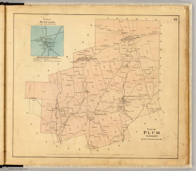
[Beers, F. W. (Frederick W.), F.W. Beers & Co.]
Full Title
Plan of Plum Township. (with) Plan of Sunville ... Entered ... 1865 ... Southern District of New York by F.W. Beers & Co. Ferd. Mayer & Co. Lithographers, 96 Fulton St., N.Y.
List No
0062.007
Note
Hand col. lithographed map. Shows landowners, etc. Inset maps at (ca. 11,880) includes business directory.
Author
[Beers, F. W. (Frederick W.), F.W. Beers & Co.]
Full Title
Plan of Pine Grove Township. Entered ... 1865 ... Southern District of New York by F.W. Beers & Co. Ferd. Mayer & Co. Lithographers, 96 Fulton St., N.Y.
List No
0062.008
Note
Hand col. lithographed map. Shows landowners, etc.
Author
[Beers, F. W. (Frederick W.), F.W. Beers & Co.]
Full Title
Plan of Richland Township. (with) Emlenton. Entered ... 1865 ... Southern District of New York by F.W. Beers & Co. Ferd. Mayer & Co. Lithographers, 96 Fulton St., N.Y.
List No
0062.009
Note
Hand col. lithographed map. Shows landowners, etc. Inset map (1:9,900) shows buildings, owners, etc.; includes business directory.
Author
[Beers, F. W. (Frederick W.), F.W. Beers & Co.]
Full Title
Plan of Oakland Township. (with) Dempseytown. Entered ... 1865 ... Southern District of New York by F.W. Beers & Co. Ferd. Mayer & Co. Lithographers, 96 Fulton St., N.Y.
List No
0062.010
Note
Hand col. lithographed map. Shows landowners, etc. Inset map (1:9,900) shows buildings, owners, etc.; includes business directory.
Author
[Beers, F. W. (Frederick W.), F.W. Beers & Co.]
Full Title
Plan of Rockland Township. (with) Plan of Rockland & Venango Coal Oil Co.'s. lands ... (Entered ... 1865 ... Southern District of New York by F.W. Beers & Co.) Ferd. Mayer & Co. Lithographers, 96 Fulton St., N.Y.
List No
0062.011
Note
Hand col. lithographed map. Shows landowners, etc. Includes 2 inset maps.
Author
[Beers, F. W. (Frederick W.), F.W. Beers & Co.]
Full Title
Plan of Irwin Township. (with) Mechanicsville. Entered ... 1865 ... Southern District of New York by F.W. Beers & Co. Ferd. Mayer & Co. Lithographers, 96 Fulton St., N.Y.
List No
0062.012
Note
Hand col. lithographed map. Shows landowners, etc. Inset map at (1:7,920) shows buildings and owners.
Author
[Beers, F. W. (Frederick W.), F.W. Beers & Co.]
Full Title
Plan of Clinton Township. Entered ... 1865 ... Southern District of New York by F.W. Beers & Co. Ferd. Mayer & Co. Lithographers, 96 Fulton St., N.Y.
List No
0062.013
Note
Hand col. lithographed map. Shows landowners, etc. Includes business directory.
Author
[Beers, F. W. (Frederick W.), F.W. Beers & Co.]
Full Title
Plan of Scrub Grass Township. Entered ... 1865 ... Southern District of New York by F.W. Beers & Co. Ferd. Mayer & Co. Lithographers, 96 Fulton St., N.Y.
List No
0062.014
Note
Hand col. lithographed map. Shows landowners, etc.
Author
[Beers, F. W. (Frederick W.), F.W. Beers & Co.]
Full Title
Plan of Canal Township. Entered ... 1865 ... Southern District of New York by F.W. Beers & Co. Ferd. Mayer & Co. Lithographers, 96 Fulton St., N.Y.
List No
0062.015
Note
Hand col. lithographed map. Shows landowners, etc. Includes Hannaville business directory.
Author
[Beers, F. W. (Frederick W.), F.W. Beers & Co.]
Full Title
Plan of Jackson Township. (with) Coopertown. Entered ... 1865 ... Southern District of New York by F.W. Beers & Co. Ferd. Mayer & Co. Lithographers, 96 Fulton St., N.Y.
List No
0062.016
Note
Hand col. lithographed map. Shows landowners, etc. Inset map at (1:9,900); shows buildings, owners, etc.; includes business directory.
Author
[Beers, F. W. (Frederick W.), F.W. Beers & Co.]
Full Title
Plan of Cherrytree Township. (with) Plan of Cherry Tree Run. (with) Cherrytree. Entered ... 1865 ... Southern District of New York by F.W. Beers & Co. Ferd. Mayer & Co. Lithographers, 96 Fulton St., N.Y.
List No
0062.017
Note
Hand col. lithographed map. Shows landowners, etc. Cherry Tree Run inset at (1:15,840) scale shows lots, etc. Cherrytree inset at (1:11,880) scale shows buildings, owners, etc.; includes business directory.
Author
[Beers, F. W. (Frederick W.), F.W. Beers & Co.]
Full Title
Plan of Allegheny Township. (with) Pleasantville. (with) Plan of Simonds Oil Territory. Entered ... 1865 ... Southern District of New York by F.W. Beers & Co. Ferd. Mayer & Co. Lithographers, 96 Fulton St., N.Y.
List No
0062.018
Note
Hand col. lithographed map. Shows landowners, etc. Pleasantville inset at (1:11,880) scale shows buildings, owners, etc.; includes business directory.
Author
[Beers, F. W. (Frederick W.), F.W. Beers & Co.]
Full Title
Plan of President Township. Entered ... 1865 ... Southern District of New York by F.W. Beers & Co. Ferd. Mayer & Co. Lithographers, 96 Fulton St., N.Y.
List No
0062.019
Note
Hand col. lithographed map. Shows landowners, etc.
Author
[Beers, F. W. (Frederick W.), F.W. Beers & Co.]
Full Title
(Plan of Harmony, Hickory, Kingsley and Tionesta townships). (with) Tionesta Borough. Entered ... 1865 ... Southern District of New York by F.W. Beers & Co. Ferd. Mayer & Co. Lithographers, 96 Fulton St., N.Y.
List No
0062.020
Note
Hand col. lithographed map. Shows landowners, etc.
Author
[Beers, F. W. (Frederick W.), F.W. Beers & Co.]
Full Title
Map of Cornplanter Township. (with) Plan of Pithole Creek. (with) Siverlyville. Entered ... 1865 ... Southern District of New York by F.W. Beers & Co. Ferd. Mayer & Co. Lithographers, 96 Fulton St., N.Y.
List No
0062.021
Note
Hand col. lithographed map. Shows landowners, etc. Pithole Creek inset at (1:31,680) scale. Siverlyville (Siverly, now part of Oil City) inset (scale not given) shows buildings, owners, etc.; includes business directory.
Author
[Beers, F. W. (Frederick W.), F.W. Beers & Co.]
Full Title
Plan of lands on Cherry Run. (with) Plumer. (with) Plan of Keister & Co.'s lands. Entered ... 1865 ... Southern District of New York by F.W. Beers & Co. Ferd. Mayer & Co. Lithographers, 96 Fulton St., N.Y.
List No
0062.022
Note
Hand col. lithographed map. Shows landowners, etc. Includes 3 inset maps and Plumer business directory. Plumer inset at (1:9,900) scale; shows buildings, owners, etc.
Author
[Beers, F. W. (Frederick W.), F.W. Beers & Co.]
Full Title
Sectional plan of Oil Creek. No. 1. Entered ... 1865 ... Southern District of New York by F.W. Beers & Co. Ferd. Mayer & Co. Lithographers, 96 Fulton St., N.Y.
List No
0062.023
Note
Hand col. lithographed map. Shows buildings, lot numbers, landowners, etc. Includes Oil City business directory.
Author
[Beers, F. W. (Frederick W.), F.W. Beers & Co.]
Full Title
Sectional plan of Oil Creek. No. 2. Entered ... 1865 ... Southern District of New York by F.W. Beers & Co. Ferd. Mayer & Co. Lithographers, 96 Fulton St., N.Y.
List No
0062.024
Note
Hand col. lithographed map in 2 segments. Shows buildings, parcel numbers, landowners, etc. Inset map: The McClintock Reserve Oil Co. on J.McClintock farm. Includes McClintockville and Rouseville business directories.
Author
[Beers, F. W. (Frederick W.), F.W. Beers & Co.]
Full Title
Sectional plan of Oil Creek. No. 3. Entered ... 1865 ... Southern District of New York by F.W. Beers & Co. Ferd. Mayer & Co. Lithographers, 96 Fulton St., N.Y.
List No
0062.025
Note
Hand col. lithographed map in 2 segments. Shows buildings, parcel numbers, landowners, etc. Includes Rynd Farm and Tarr Farm business directories.
|


![Plan sushestvuyushago i proektirovannago ragpolojenia gubernskago goroda Baku, c' ponazaniem'..., 1898-1900 g. [i.e. Plan of the existing and projected location of Baku]](https://www.davidrumsey.com/rumsey/Size2/RUMSEY~8~1/199/15269000.jpg)