|
Author
[Gorshkov, Sergei Georgievich, Soviet Union. Voenno-Morskoĭ Flot]
Full Title
Porty Islandii, Iugo-zapadnoy Skandinavii i proliva zund. (to accompany) Atlas okeanov : Atlanticheskiy i Indiyskiy Okeany 1977.
List No
13623.206
Note
10 maps on 1 sheet. showing maps and plans of the islands and major ports of North Atlantic. Including ports of Iceland, Southwest Scandinavia and the Sound.
Author
[Gorshkov, Sergei Georgievich, Soviet Union. Voenno-Morskoĭ Flot]
Full Title
Kil'skiy Kanal i porty Gel'golandskoy bukhty. (to accompany) Atlas okeanov : Atlanticheskiy i Indiyskiy Okeany 1977.
List No
13623.207
Note
Map of Kiel Canal and Helgoland Bay. Includes 6 insets maps and plans of the islands and major ports. Includes tables.
Author
[Gorshkov, Sergei Georgievich, Soviet Union. Voenno-Morskoĭ Flot]
Full Title
Ust'ye Reki Gudzon i N'yu -York. (to accompany) Atlas okeanov : Atlanticheskiy i Indiyskiy Okeany 1977.
List No
13623.219
Note
Map of the Estuary of the Hudson River and New York. Showing shipping routes and distances. Relief shown by gradient tints and spot heights. Depth shown by bathymetric tints, isolines and soundings. Include elevation bar.
Author
[Gorshkov, Sergei Georgievich, Soviet Union. Voenno-Morskoĭ Flot]
Full Title
Yugo-Vostochnaia chasti Indiyskogo Okeana. (to accompany) Atlas okeanov : Atlanticheskiy i Indiyskiy Okeany 1977.
List No
13623.226
Note
1 map on 2 sheets. Showing Southeast part of Indian Ocean. Relief shown by gradient tints and spot heights. Depth shown by bathymetric tints, isolines and soundings. Include elevation bar.
Author
[Gorshkov, Sergei Georgievich, Soviet Union. Voenno-Morskoĭ Flot]
Full Title
Porty Vostochnoy chasti Indiyskogo Okeana i Maskarenskikh Ostrovov. (to accompany) Atlas okeanov : Atlanticheskiy i Indiyskiy Okeany 1977.
List No
13623.227
Note
11 maps on 1 sheet. Ports of the Eastern Indian Ocean and the Mascarene Islands. Relief shown by gradient tints and spot heights. Depth shown by bathymetric tints, isolines and soundings. Include elevation bar.
Author
Andriveau-Goujon, E. (Eugène), 1832-1897
Full Title
Navigation à vapeur dans le bassin de Méditerranée et chemins de der de 'Europe centrale. Publiée par E. Andriveau-Goujon, Rue du Bac, 21. Paris, 1860, Impie. de Louis Antoine; le trait gravé par Smith; les escritures par P. Rousset.
List No
15659.002
Author
[Glavnoe Upravlenie Navigat︠s︡ii i Okeanografii Ministerstva Oborony SSSR., Soviet Union. Voenno-Morskoĭ Flot.]
Full Title
Vazhneyshie Russkiie Ekspeditsii po serediny XIX Veka. (To accompany) Atlas okeanov : Tikhiy Okean = Atlas of the Oceans : Pacific Ocean. 1974.
List No
13622.014
Note
Circular map of the Pacific Ocean. Extending from the Arctic region in the north to Antarctic in the south, between continents of Asia, Australia on the west and Americas on the east. Showing the most important Russian Expeditions in the middle of the 19th century with expedition routes. Includes list of exploration date, explorers and expedition routes in color.
Author
[Glavnoe Upravlenie Navigat︠s︡ii i Okeanografii Ministerstva Oborony SSSR., Soviet Union. Voenno-Morskoĭ Flot.]
Full Title
Vazhneyshie ekspeditsii 1804 - 1871 gg. (To accompany) Atlas okeanov : Tikhiy Okean = Atlas of the Oceans : Pacific Ocean. 1974.
List No
13622.018
Note
Map of the major expedition in Pacific Ocean 1804-1871 gg. Includes legend.
Author
[Glavnoe Upravlenie Navigat︠s︡ii i Okeanografii Ministerstva Oborony SSSR., Soviet Union. Voenno-Morskoĭ Flot.]
Full Title
Vazhneyshie Okeanograficheskie ekspeditsii 1957 - 1960 gg. (To accompany) Atlas okeanov : Tikhiy Okean = Atlas of the Oceans : Pacific Ocean. 1974.
List No
13622.022
Note
Map of the major Oceanographic expedition in Pacific Ocean 1957-1960. Includes legend.
Author
[Glavnoe Upravlenie Navigat︠s︡ii i Okeanografii Ministerstva Oborony SSSR., Soviet Union. Voenno-Morskoĭ Flot.]
Full Title
Vazhneyshie Okeanograficheskie ekspeditsii 1961 - 1970 gg. (To accompany) Atlas okeanov : Tikhiy Okean = Atlas of the Oceans : Pacific Ocean. 1974.
List No
13622.023
Note
Map of the major Oceanographic expedition in Pacific Ocean 1961-1970. Includes legend.
Author
[Glavnoe Upravlenie Navigat︠s︡ii i Okeanografii Ministerstva Oborony SSSR., Soviet Union. Voenno-Morskoĭ Flot.]
Full Title
Porty zaliva p'yudzhet - saund. (To accompany) Atlas okeanov : Tikhiy Okean = Atlas of the Oceans : Pacific Ocean. 1974.
List No
13622.208
Note
Map of the Puget Sound. Includes 7 inset plans of major ports. Includes elevation bars.
Author
[Glavnoe Upravlenie Navigat︠s︡ii i Okeanografii Ministerstva Oborony SSSR., Soviet Union. Voenno-Morskoĭ Flot.]
Full Title
Porty kalifornii. (To accompany) Atlas okeanov : Tikhiy Okean = Atlas of the Oceans : Pacific Ocean. 1974.
List No
13622.209
Note
Map of the ports of California. Includes 3 inset plans of the major ports. Includes elevation bars.
Author
[Glavnoe Upravlenie Navigat︠s︡ii i Okeanografii Ministerstva Oborony SSSR., Soviet Union. Voenno-Morskoĭ Flot.]
Full Title
Porty tokiyskogo zaliva i vnutrennego yaponskogo moria. (To accompany) Atlas okeanov : Tikhiy Okean = Atlas of the Oceans : Pacific Ocean. 1974.
List No
13622.212
Note
Map of the Tokyo Bay and Inland Sea ports. Includes 4 inset maps of major ports. Relief shown by gradient tints and spot heights. Depth shown by bathymetric tints, isolines and soundings. Include elevation bar.
Author
[Glavnoe Upravlenie Navigat︠s︡ii i Okeanografii Ministerstva Oborony SSSR., Soviet Union. Voenno-Morskoĭ Flot.]
Full Title
Gavayskiye Ostrova i Atolly Ueyk i Dzhonston. (To accompany) Atlas okeanov : Tikhiy Okean = Atlas of the Oceans : Pacific Ocean. 1974.
List No
13622.217
Note
Map of the Hawaiian islands and Wake and Johnston Atolls. Includes 5 inset maps of major ports. Relief shown by gradient tints and spot heights. Depth shown by bathymetric tints, isolines and soundings. Include elevation bar.
Author
[Glavnoe Upravlenie Navigat︠s︡ii i Okeanografii Ministerstva Oborony SSSR., Soviet Union. Voenno-Morskoĭ Flot.]
Full Title
Panamskiy Kanal. (To accompany) Atlas okeanov : Tikhiy Okean = Atlas of the Oceans : Pacific Ocean. 1974.
List No
13622.220
Note
Map of the Panama Canal. Showing international boundaries. Includes 2 inset maps of major ports. Relief shown by gradient tints and spot heights. Depth shown by bathymetric tints, isolines and soundings. Include elevation bar.
Author
[Glavnoe Upravlenie Navigat︠s︡ii i Okeanografii Ministerstva Oborony SSSR., Soviet Union. Voenno-Morskoĭ Flot.]
Full Title
Porty zapadnogo poberezh'ya Tsentral'noy i Iuzhnoy Ameriki. (To accompany) Atlas okeanov : Tikhiy Okean = Atlas of the Oceans : Pacific Ocean. 1974.
List No
13622.221
Note
2 maps of the Western ports of the coasts of Central and South America. Relief shown by gradient tints and spot heights. Depth shown by bathymetric tints, isolines and soundings. Include elevation bar.
Author
[Glavnoe Upravlenie Navigat︠s︡ii i Okeanografii Ministerstva Oborony SSSR., Soviet Union. Voenno-Morskoĭ Flot.]
Full Title
More Rossa. (To accompany) Atlas okeanov : Tikhiy Okean = Atlas of the Oceans : Pacific Ocean. 1974.
List No
13622.222
Note
Bathymetric map of the Ross Sea, Antarctica on 2 sheets. Relief shown by hachures and spot heights. Depth shown by bathymetric tints, isolines and soundings. Include elevation bar.
Author
[Glavnoe Upravlenie Navigat︠s︡ii i Okeanografii Ministerstva Oborony SSSR., Soviet Union. Voenno-Morskoĭ Flot.]
Full Title
Ostrova i porty Okeanii. (To accompany) Atlas okeanov : Tikhiy Okean = Atlas of the Oceans : Pacific Ocean. 1974.
List No
13622.224
Note
16 maps of the ports of Oceania. Relief shown by gradient tints and spot heights. Depth shown by bathymetric tints, isolines and soundings. Include elevation bar.
Author
Bellin, Jacques Nicolas, 1703-1772
Full Title
Carte Generale des Costes de Bretagne. (Tom 1)
List No
15613.002
Author
Bellin, Jacques Nicolas, 1703-1772
Full Title
1r. Carte Particuliere des Costes de Bretagne.(with panel upside down) (Tom 1)
List No
15613.003
Author
Bellin, Jacques Nicolas, 1703-1772
Full Title
1r. Carte Particuliere des Costes de Bretagne. (with panel rotated 180 degrees) (Tom 1)
List No
15613.004
Author
Bellin, Jacques Nicolas, 1703-1772
Full Title
2me. Carte Particuliere des Costes de Bretagne. (Tom 1)
List No
15613.005
Author
Bellin, Jacques Nicolas, 1703-1772
Full Title
3. Carte Particuliere des Costes de Bretagne. (Tom 1)
List No
15613.006
Author
Bellin, Jacques Nicolas, 1703-1772
Full Title
4me. Carte Particuliere des Costes de Bretagne. (Tom 1)
List No
15613.007
Author
Bellin, Jacques Nicolas, 1703-1772
Full Title
5e. Carte Particuliere des Costes de Bretagne.(Tom 2)
List No
15613.008
Author
Bellin, Jacques Nicolas, 1703-1772
Full Title
6me. Carte Particuliere des Costes de Bretagne.(Tom 2)
List No
15613.009
Author
Bellin, Jacques Nicolas, 1703-1772
Full Title
7me. Carte Particuliere des Costes de Bretagne.(Tom 2)
List No
15613.010
Author
Bellin, Jacques Nicolas, 1703-1772
Full Title
8eme. Carte Particuliere des Costes de Bretagne.(Tom 2)
List No
15613.011
Author
[Bellin, Jacques Nicolas, 1703-1772, Magin, M.]
Full Title
Carte Geometirque De L'Entree De La Riviere De Loire (Tom 2)
List No
15613.012
Author
Bellin, Jacques Nicolas, 1703-1772
Full Title
Carte Reduite des Isles de Jersey Grenesey et d'Aurigny Avec les Costes de Normandie et de Bretagne qui en sont Voisines . . . M.DCC.LVII
List No
15613.013
Author
[Bellin, Jacques Nicolas, 1703-1772, Magin, M.]
Full Title
Carte Geometrique De L'Entree De La Rivierre De Bordeaux (Tom 3)
List No
15613.014
Author
Bellin, Jacques Nicolas, 1703-1772
Full Title
Carte Reduite De La Manche. (Tom 3)
List No
15613.015
Author
[Bellin, Jacques Nicolas, 1703-1772, De Gaulle, M.]
Full Title
Carte Hydrographique De L'Embouchure De La Seine. (Tom 3)
List No
15613.016
Author
Bellin, Jacques Nicolas, 1703-1772
Full Title
Carte Reduite du Golphe de Gascogne (Tom 3)
List No
15613.017
Author
Bellin, Jacques Nicolas, 1703-1772
Full Title
Carte Reduite Des Costes De France De Portugal Et D'Espagne. (Tom 4)
List No
15613.018
Author
Bellin, Jacques Nicolas, 1703-1772
Full Title
Cotes de France: Departement de Calvados, depuis le Havre de Grace jusqu'a Isigny: d'aprees les Plans leves en 1776, Par Le Couldre-La Bretonnieree . . . . 1792. l'An 1er de la Republique (Tom 4)
List No
15613.019
Author
Bellin, Jacques Nicolas, 1703-1772
Full Title
Cotes de France: Departemens Du Pas De Calais et De La Somme, deupuis Calais jusqu'a l'Entree de la Somme: d'aprees les Plans leves en 1776, Par Le Couldre-La Bretonnieree . . . . 1792. l'An 1er de la Republique (Tom 4)
List No
15613.020
Author
Bellin, Jacques Nicolas, 1703-1772
Full Title
Plan de la Rade De Dunkerque Leve par Ordre du Roi en 1776. Sous le Ministere de M. de Sartine . . . . 1778 (Tom 4)
List No
15613.021
Author
Bellin, Jacques Nicolas, 1703-1772
Full Title
Cotes de France: Departemens Du Nord et Du Pas De Calais depuis Nieuport jusqu'a Ambleteuse: d'aprees les Plans leves en 1776, Par Le Couldre-La Bretonnieree . . . . 1792. l'An 1er de la Republique (Tom 4)
List No
15613.022
Author
Bellin, Jacques Nicolas, 1703-1772
Full Title
Cotes de France: Departement de La Manche, depuis Isigny et le Gd. Vay jusqu'au Cap Cartaret: d'aprees les Plans leves en 1777, Par Le Couldre-La Bretonnieree . . . . 1792. l'An 1er de la Republique (Tom 5)
List No
15613.023
Author
Bellin, Jacques Nicolas, 1703-1772
Full Title
Cotes de France: Departemens De La Manche et De L'Illes e Vilaine, depuis le Cap Carteret jusqu'a l'Ille des Embiez: d'aprees les Plans leves en 1777, Par Le Couldre-La Bretonnieree . . . . 1792. l'An 1er de la Republique (Tom 5)
List No
15613.024
Author
Bellin, Jacques Nicolas, 1703-1772
Full Title
Cotes de France: Departemens De La Somme et de la Seine Inferieure, depuis l'entre de la Somme jusqua'a Fecamp: d'aprees les Plans leves en 1776, Par Le Couldre-La Bretonnieree . . . . 1792. l'An 1er de la Republique (Tom 5)
List No
15613.025
Author
Bellin, Jacques Nicolas, 1703-1772
Full Title
Cotes de France: Departemens De La Seine Inferieure, depuis Fecamp jusqu'a Dives: d'aprees les Plans leves en 1776, Par Le Couldre-La Bretonnieree . . . . 1792. l'An 1er de la Republique (Tom 5)
List No
15613.026
Author
Bellin, Jacques Nicolas, 1703-1772
Full Title
Carte Reduite de Costes de Flandre et de Hollande Depuis la Pas de Calais jusqu'a l'Elbe, et les Costes d'Angleterre Opposees . . . M.DCC.LXIII (Tom 5)
List No
15613.027
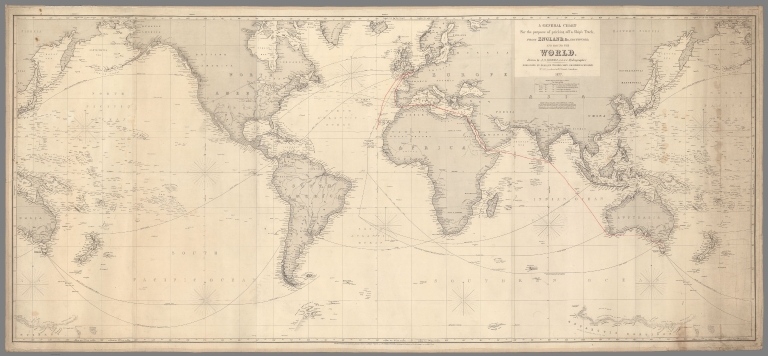
Author
[Hobbs, J.S., Heather, William, 1764-1812, Norie, J.W.]
Full Title
A General Chart For the purpose of pricking off a Ship’s Track from England, &c. Southward, and round the World. Drawn by J.S. Hobbs, F.R.G.S. Hydrographer. 1877.
List No
15548.000
Author
Maury, Matthew Fontaine, 1806-1873
Full Title
Monsoon and Trade Wind Chart of the Indian Ocean.
List No
15547.000
Author
[Nusret, Milford Haven, Louis Alexander Mountbatten, Marquis of, 1854-1921]
Full Title
(Text Page to) [Example 1]. -- [Map 1].
List No
14475.007
Note
Description of navigation in [Martin'in manevra levhasiyla Batenberg'in rota müs'irinin sûret-i istimaline mahsûs talimat], Example 1. Text in Arabic, printed in black and red. With associated circular map on facing page, also printed in black and red. Includes a legend, bar scale and notes. Map features the route of a vessel by Prince Louis Alexander of Battenberg (1854-1921), a British naval officer and the first Marquess of Milford Haven, who commanded the British Atlantic Fleet from 1908 to 1910 and became First Sea Lord in 1912. Text in this volume was translated by Nusret - a lieutenant in the Ottoman Naval Forces - for use by Turkish naval officers. Map is 20 x 20 cm, on sheet 28 x 28 cm.
Author
[Nusret, Milford Haven, Louis Alexander Mountbatten, Marquis of, 1854-1921]
Full Title
(Text Page to) [Example 2]. -- [Map 2].
List No
14475.008
Note
Description of navigation in [Martin'in manevra levhasiyla Batenberg'in rota müs'irinin sûret-i istimaline mahsûs talimat], Example 2. Text in Arabic, printed in black. With associated circular map on facing page, printed in black and red. Includes a legend, bar scale and notes. Map features the route of a vessel by Prince Louis Alexander of Battenberg (1854-1921), a British naval officer and the first Marquess of Milford Haven, who commanded the British Atlantic Fleet from 1908 to 1910 and became First Sea Lord in 1912. Text in this volume was translated by Nusret - a lieutenant in the Ottoman Naval Forces - for use by Turkish naval officers. Map is 20 x 20 cm, on sheet 28 x 28 cm.
Author
[Nusret, Milford Haven, Louis Alexander Mountbatten, Marquis of, 1854-1921]
Full Title
(Text Page to) [Example 3]. -- [Map 3].
List No
14475.009
Note
Description of navigation in [Martin'in manevra levhasiyla Batenberg'in rota müs'irinin sûret-i istimaline mahsûs talimat], Example 3. Text in Arabic, printed in black and red. With associated circular map on facing page, also printed in black and red. Includes a legend, bar scale and notes. Map features the route of a vessel by Prince Louis Alexander of Battenberg (1854-1921), a British naval officer and the first Marquess of Milford Haven, who commanded the British Atlantic Fleet from 1908 to 1910 and became First Sea Lord in 1912. Text in this volume was translated by Nusret - a lieutenant in the Ottoman Naval Forces - for use by Turkish naval officers. Map is 20 x 20 cm, on sheet 28 x 28 cm.
Author
[Nusret, Milford Haven, Louis Alexander Mountbatten, Marquis of, 1854-1921]
Full Title
(Text Page to) [Example 4]. -- [Map 4].
List No
14475.010
Note
Description of navigation in [Martin'in manevra levhasiyla Batenberg'in rota müs'irinin sûret-i istimaline mahsûs talimat], Example 4. Text in Arabic, printed in black and red. With associated circular map on facing page, also printed in black and red. Includes a legend, bar scale and notes. Map features the route of a vessel by Prince Louis Alexander of Battenberg (1854-1921), a British naval officer and the first Marquess of Milford Haven, who commanded the British Atlantic Fleet from 1908 to 1910 and became First Sea Lord in 1912. Text in this volume was translated by Nusret - a lieutenant in the Ottoman Naval Forces - for use by Turkish naval officers. Map is 20 x 20 cm, on sheet 28 x 28 cm.
|


![Text: [Example 1]. ...](https://www.davidrumsey.com/rumsey/Size2/RUMSEY~8~1/205/14475007.jpg)
![Text: [Example 2]. ...](https://www.davidrumsey.com/rumsey/Size2/RUMSEY~8~1/205/14475008.jpg)
![Text: [Example 3]. ...](https://www.davidrumsey.com/rumsey/Size2/RUMSEY~8~1/205/14475009.jpg)
![Text: [Example 4]. ...](https://www.davidrumsey.com/rumsey/Size2/RUMSEY~8~1/205/14475010.jpg)