|
REFINE
Browse All : Nautical Charts of West Indies
1-46 of 46
Author
[Norman, William, -1807, Carleton, Osgood, 1742-1816]
Full Title
A new general chart of the West Indies from the latest marine journals and surveys, regulated and ascertained by astronomical observations ... Printed & sold by W. Norman
List No
14485.009
Note
Nautical chart representing the West Indies. Shows islands, cities, bodies of water, drainage, coastlines, bays, and ports. Includes rhumb lines, latitudinal and longitudinal lines, scale of nautical leagues, as well as a compass rose with north oriented toward top of sheet. Black and white engraving. "I the subscriber do certify that I have carefully examined this chart copied from a London publication agreeable to Act of Parliament and find it a true and accurate copy of the original. Osgood Carleton, Teacher of Navigation and other Branches of the Mathematics. Boston. Decr. 28th 1789." Chart is 69 x 99 cm, on fold-out sheet 71 x 101 cm.
Author
[Faden, William, 1749-1836, Sayer, Robert, 1725-1794]
Full Title
A new general chart of the West Indies from the latest marine journals and surveys, regulated and ascertained by astronomical observations. London, printed fro R. Sayer, print seller No. 53 Fleet Street as the Act directs, July 1st. 1790.
List No
14383.058
Note
Nautical chart of the West Indies, as of 1790. Shows political boundaries, cities, ports, topography, bodies of water, drainage, coastlines, islands, sand banks and depths. Relief shown with hachures. Includes latitudinal and longitudinal lines, as well as rhumb lines and compass roses with north oriented toward top of sheet. With arrows indicating the direction of water flow. Decorative cartouche. Hand-colored engraving. Map is 66 x 100 cm, on fold-out sheet 76 x 106 cm. With stamp: Liverpool Library.
Author
Mount and Davidson
Full Title
A New Generall Chart for the West Indies of E. Wright's Projection.
List No
12434.007
Author
Norie, J.W.
Full Title
A New Chart of the Windward Passages Containing the Islands of Jamaica, St. Domingo, with Part of Cuba, &c. Drawn from the latest English, Spanish & French Surveys, by J.W. Norie, Hydrogr. 1836. A New Edition. Corrected to 1846.
List No
6719.000
Note
Shows the navigation around the east end of Cuba, Jamaica, Haiti, and St. Domingo. With 10 shore profiles.
Author
Jansson, Johannes, 1588-1664
Full Title
Insularum Hispaniolae et Cubae cum insulis circum jacentibus accurata delineatio.
List No
10056.040
Author
Jansson, Johannes, 1588-1664
Full Title
Insula S. Juan de Puerto Rico Caribes vel Canibasum Insulae.
List No
10056.008
Author
Goos, Pieter, 1616-1675
Full Title
Pascaerte van Westindien de Vuste Kusten En de Eylanden.
List No
12179.042
Author
Goos, Pieter, 1616-1675
Full Title
Pascaert Vande Caribes Eylanden.
List No
12179.043
Note
North to the right.
Author
van Keulen, Joannes
Full Title
Pascaerte van Westindien.
List No
12203.018
Author
Mount and Davidson
Full Title
A Correct Chart of the Caribbee Islands.
List No
12434.043
Author
Mount and Davidson
Full Title
A New and Correct Chart of the Trading Part of the West Indies.
List No
12434.067
Note
Foldout
Author
Luffman, John, 1756-1846
Full Title
Porto Bello. Engraved for Luffman's Select plans. Engrav'd & Publish'd Novr. 1. 1801, by J. Luffman. London.
List No
13189.121
Note
Hand colored chart of the port city and fortifications. Prime meridian is London. Depth shown by soundings. Includes historical text at the foot of map.
Author
[Lattre, Jean, 1743 -1793, Rizzi-Zannoni, Giovanni Antonio 1736-1814]
Full Title
Carte geo-hydrographique du Golfe du Mexique et de ses Isles : construite d'apres les memoires le plus recens, et assujeties, pour l'emplacement de ces principales positions aux latitudes et longitudes, determinées par observation. Par M. Rizzi Zannoni ... A Paris, Chez Lattre Graveur ... (to accompany) Atlas moderne ou collection de cartes sur toutes les parties du globe terrestre.
List No
13420.041
Note
Engraved outlined hand color chart. Shows political boundaries and place names. Relief shown pictorially. Includes ornamental title cartouche. Prime meridian is Paris.
Author
[Stanford, Edward, 1827-1904, Arrowsmith, John, 1790-1873]
Full Title
74. West Indies. By J. Arrowsmith. London: Edward Stanford, 55 Charing Cross, S.W.
List No
14053.038
Note
Map of the West Indies, in colored lithograph and on double plate. Shows political boundaries, railways, ocean routes, reefs, banks and shoals. Relief illustrated with hachures. Includes a legend, as well as two bar scales. With Note, beginning: The old Spanish navigators often distinguish the W. India Is. into 2 classes by the terms Bartovento & Sotovento ... 47 x 62 cm, on sheet 56 x 68 cm. In Vol. I.
Author
Masi, Giovanni Tommaso
Full Title
Nuova e corretta Carta dell'Indie Occidentali cavata dalle migliori autorità. D. Veremondo Rossi Monaco Valinise.
List No
14343.028
Note
Map of the West Indies and vicinity. Shows political boundaries, cities, ports, topography, drainage, coastlines, shoals and islands. Relief shown pictorially. Includes latitudinal and longitudinal lines, as well as a compass rose, with north oriented toward top of sheet. Black and white engraving, with title in decorative cartouche. Map is 26 x 33 cm, on fold-out sheet 37 x 48 cm. Descriptive text for map appears on page 9 of Dexcrizione delle carte geografiche, which precedes maps.
Author
[Geological Survey (U.S.), U. S. Coast and Geodetic Survey, United States. Naval Oceanographic Office]
Full Title
General charts : [North America] / adapted from U. S. Naval Oceanographic Office, Catalog of nautical charts and publication, introduction, pt. I, 4th ed., no. 1-N, Washington, 1967 -- Pilot chart : [Bahama Islands] -- General chart : [Great Bahama Bank] -- World bathymetric chart : [West Indies].
List No
14359.226
Note
Four nautical charts representing North America and its adjacent waters, as well the Bahamas and the West Indies, as of 1968. Charts show cities, topography, bodies of water, drainage, coastlines, islands, shoals and water depths. Relief shown with shading. Charts include legends, as well as scale statements (scales differ) and arrows indicating directions of ocean currents. First chart provides an index to other charts with further detail. Colored lithograph. Together, charts are 42 x 31 cm, on sheet 49 x 35 cm. Accompanied by descriptive text. Charts appear in Special subject maps section, subsection Mapping and charting.
Author
Cram, George Franklin, 1841-1928
Full Title
West Indies.
List No
14372.297
Note
Map of the West Indies. Shows political boundaries, cities, railroads, topography, bodies of water, drainage, coastlines and islands. Relief shown with hachures. Includes latitudinal and longitudinal lines, as well as water routes with distances and a bar scale given in miles. Provides figures for square milage and population. Map indexed to indicate place names. Colored lithograph. Map is 40 x 56 cm, on double sheet 45 x 67 cm.
Author
Bellin, Jacques Nicolas, 1703-1772
Full Title
Carte reduite du golphe Mexique et des isles de I'Amerique.
List No
6903.055
Note
Decorative title cartouche. Relief shown pictorially.
Author
Bellin, Jacques Nicolas, 1703-1772
Full Title
Carte de I'isle de Sainte Croix au sud des isles des Vierges. Carte de I'isle de Saint Jean de Portorico.
List No
6903.083
Note
Two maps on one chart. Relief shown pictorially and by hachures. Shows settlements.
Author
Bellin, Jacques Nicolas, 1703-1772
Full Title
Port et ville de Porto-rico dans I'isle de ce nom.
List No
6903.084
Note
Decorative title cartouche. Relief shown pictorially and by hachures. Depth shown by soundings. Shows settlements.
Author
Bellin, Jacques Nicolas, 1703-1772
Full Title
Cartes des isles des Vierges.
List No
6903.085
Note
Decorative title cartouche. Relief shown pictorially. Shows settlements.
Author
Bellin, Jacques Nicolas, 1703-1772
Full Title
Carte de I'isle St Thomas I'une des Vierges.
List No
6903.086
Note
Decorative title cartouche. Relief shown pictorially. Depth shown by soundings. Shows settlements.
Author
Bellin, Jacques Nicolas, 1703-1772
Full Title
Les Petites Antilles ou les isles du Vent. Croisey, aculp.
List No
6903.087
Note
Decorative title cartouche. Relief shown pictorially. Shows towns and ports.
Author
Bellin, Jacques Nicolas, 1703-1772
Full Title
Partie des isles Antilles, 1 partie.
List No
6903.088
Note
Decorative title cartouche. Relief shown pictorially. Shows settlements.
Author
Bellin, Jacques Nicolas, 1703-1772
Full Title
Suite des isles Antilles, 2 partie.
List No
6903.089
Note
Decorative title cartouche. Relief shown pictorially. Shows settlements.
Author
Bellin, Jacques Nicolas, 1703-1772
Full Title
Petites Antilles ou isles du Vent. 3 partie.
List No
6903.090
Note
Decorative title cartouche. Relief shown pictorially. Shows settlements.
Author
Bellin, Jacques Nicolas, 1703-1772
Full Title
Carte de I'isle de St Christophe.
List No
6903.091
Note
Decorative title cartouche. Relief shown pictorially. Shows settlements.
Author
Bellin, Jacques Nicolas, 1703-1772
Full Title
Carte de I'isle de Nieves.
List No
6903.092
Note
Decorative title cartouche. Relief shown pictorially and by hachures. Depth shown by soundings. Shows settlements.
Author
Bellin, Jacques Nicolas, 1703-1772
Full Title
Carte de I'isle d'Antigue.
List No
6903.093
Note
Decorative title cartouche. Relief shown pictorially and by hachures. Depth shown by soundings. Shows settlements.
Author
Bellin, Jacques Nicolas, 1703-1772
Full Title
Isle de la Guadeloupe, les Saintes et Marie Galante. Croisey, sculp.
List No
6903.094
Note
Decorative title cartouche. Relief shown pictorially and by hachures. Shows settlements.
Author
Bellin, Jacques Nicolas, 1703-1772
Full Title
Partie occidentale de I'isle de la Guadeloupe appellee la Basse Terre. Croisey, sculp.
List No
6903.095
Note
Decorative title cartouche. Relief shown pictorially and by hachures. Shows settlements and roads.
Author
Bellin, Jacques Nicolas, 1703-1772
Full Title
Partie orientale de I'isle de la Guadeloupe appellee la Grande Terre. Croisey, sculp.
List No
6903.096
Note
Decorative title cartouche. Relief shown pictorially and by hachures. Shows settlements and roads.
Author
Bellin, Jacques Nicolas, 1703-1772
Full Title
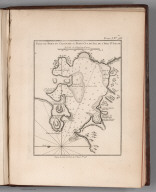
Environs du fort Louis de la Guadeloupe. Croisey Bc[ulp.]
List No
6903.097
Note
Decorative title cartouche. Relief shown pictorially and by hachures. Depth shown by soundings. Shows settlements.
Author
Bellin, Jacques Nicolas, 1703-1772
Full Title
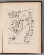
Carte de I'isle de Mari-Galante. Croisey sc[ulp.]
List No
6903.098
Note
Decorative title cartouche. Relief shown pictorially and by hachures. Shows settlements.
Author
Bellin, Jacques Nicolas, 1703-1772
Full Title
Isle de la Martinique.
List No
6903.099
Note
Decorative title cartouche. Relief shown pictorially and by hachures. Shows settlements and roads.
Author
Bellin, Jacques Nicolas, 1703-1772
Full Title
Partie septentrionale de la Martinique. Croisey sc[ulp.]
List No
6903.100
Note
Decorative title cartouche. Relief shown pictorially and by hachures. Shows settlements and roads.
Author
Bellin, Jacques Nicolas, 1703-1772
Full Title
Partie meridionale de la Martinique. Croisey sc[ulp.]
List No
6903.101
Note
Decorative title cartouche. Relief shown pictorially and by hachures. Shows settlements and roads.
Author
Bellin, Jacques Nicolas, 1703-1772
Full Title
Plan du Cul de Sac Royal de la Martinique.
List No
6903.102
Note
Decorative title cartouche. Relief shown pictorially and by hachures. Depth shown by soundings. Shows settlements.
Author
Bellin, Jacques Nicolas, 1703-1772
Full Title
Carte de I'isle Sainte Lucie
List No
6903.103
Note
Decorative title cartouche. Relief shown pictorially and by hachures. Shows settlements and roads.
Author
Bellin, Jacques Nicolas, 1703-1772
Full Title
Plan du port du Carenage oil petit Cul de Sac de I'isle S Lucie.
List No
6903.104
Note
Relief shown pictorially and by hachures. Depth shown by soundings. Shows settlements.
Author
Bellin, Jacques Nicolas, 1703-1772
Full Title
Plan du Cul de Sac des Roseaux dans I'isles de Ste Lucie.
List No
6903.105
Note
Relief shown pictorially and by hachures. Depth shown by soundings. Shows settlements.
Author
Bellin, Jacques Nicolas, 1703-1772
Full Title
Carte de I'isle de la Barbade.
List No
6903.106
Note
Decorative title cartouche. Relief shown pictorially and by hachures. Shows settlements.
Author
Bellin, Jacques Nicolas, 1703-1772
Full Title
Carte de I'isle Saint Vincent.
List No
6903.107
Note
Relief shown pictorially and by hachures. Shows settlements and roads.
Author
Bellin, Jacques Nicolas, 1703-1772
Full Title
Plan du port et du Carenage de Cariacoua situe dans la partie du sud de I'isle de St Vincent.
List No
6903.108
Note
Relief shown pictorially and by hachures. Depth shown by soundings. Shows settlements.
Author
Bellin, Jacques Nicolas, 1703-1772
Full Title
Carte de I'isle de la Grenade
List No
6903.109
Note
Decorative title cartouche. Relief shown pictorially and by hachures. Shows settlements.
Author
Bellin, Jacques Nicolas, 1703-1772
Full Title
Port et fort Royal de la Grenade.
List No
6903.110
Note
Decorative title cartouche. Relief shown pictorially and by hachures. Depth shown by soundings. Shows settlements and roads.
1-46 of 46
|


![Environs du fort Louis de la Guadeloupe. Croisey Bc[ulp.]](https://www.davidrumsey.com/rumsey/Size1/D5005/6903097.jpg)
![Carte de I'isle de Mari-Galante. Croisey sc[ulp.]](https://www.davidrumsey.com/rumsey/Size1/D5005/6903098.jpg)

![Partie septentrionale de la Martinique. Croisey sc[ulp.]](https://www.davidrumsey.com/rumsey/Size2/D5005/6903100.jpg)
![Partie meridionale de la Martinique. Croisey sc[ulp.]](https://www.davidrumsey.com/rumsey/Size2/D5005/6903101.jpg)