|
Author
Duval, Henri (Henri Louis Nicolas), 1783-1854
Full Title
Tableau de géologie et des révolutions du globe. Par Henri Duval, Chevalier de la Légion-d'Honneur; Professeur d'Histoire, de Géographie, de Belles-Lettres, etc., etc. Gravé par Laguillermie rue des Noyers No. 56. Delloye, Libraire, Place de la Bourse, No 13. Tous les Exemplaires ont le Timbre de l'Auteur. Imprimerie de Terzuolo, Successeur de M. Plassan, Rue de Vaugirard, No 11.
List No
14254.045
Note
Engraved, hand-colored view illustrating the tallest mountains from around the world, as well as volcanoes. Mountains indexed in association with a table giving peak heights. Title translates to: Table of geology and revolutions of the globe. Accompanied by descriptive text in tables within margins, covering geological phenomena, such as volcanoes, minerals and animal fossils. With addresses in top corners: L'Auteur, Rue des Martyrs, no 23, Chaussée-d'Antin -- Adopté pour les maisons Royles d'Éducation de la Légion-d'Honneur. View is 22 x 23 cm, on sheet 42 x 61 cm. In third section: Sciences [= Science].
Author
Schwegler & fils
Full Title
Panorama du Pilate prise sur l' Esel, 6532' au dessus de la mer. [Panorama of Pilate taken on the Esel, 6532' above the sea.]
List No
15719.001
Author
[Hickmann, Anton Leo, 1834-1906, Fischer, Alois, b. 1894]
Full Title
Ideale ansichtder bedeutendsten hohen und Tiefen und Tiefen der erde. G. Freytag & Berndt A.G., Wien. (to accompany) Prof. Hickmann's Geographisch-statistischer universal-atlas, 1927.
List No
13687.008
Note
4 views on 1 sheet. Including comparative view of the Heights of the Principal Mountains and depths of seas in the world. With comparative view of the elevations of the Alps and the depth of the Mediterranean Sea. Relief shown by spot heights. Depth shown by soundings.
Author
[Sydow, Emil von., 1812-1873, Wagner, Hermann, 1840-1929]
Full Title
Ungarische Tiefebene und Karpaten. Gotha : Justus Perthes. Sydow-Wagners method. Schul-Atlas. XXI.
List No
13557.095
Note
Map of the Hungarian Plain and Carpatian Mountains. With inset map: Budapest. Vereinfachte Kegelprojektion.
Author
W. & A.K. Johnston Limited
Full Title
Table of the comparative heights of the principal mountains in the world. Edinburgh; W. & A.K. Johnston ; Glasgow; Robert Weir ; Lumsden & Son.
List No
14296.055
Note
Chart of mountain heights around the world. Shows elevations of peaks - in thousands of feet - from tallest to shortest. Peaks indexed with letters; explanatory table at upper right, providing the name of each mountain and its location (according to country), and height in feet. Includes volcanoes, which are indicated by puffs of smoke. Descriptive note, beginning: The region of perpetual snow begins under the equator at 15,747 feet above the level of the sea ... With two inset charts: Passes of the Alps, above the level of the sea -- Altitude of towns, above the level of the sea. Chart is 21 x 29 cm, on sheet 27 x 35 cm. Black and white engraving. Unnumbered plate. In second section of atlas, Modern maps.
Author
Desjardins, Constant
Full Title
Esquisse des eaux et des montagnes de l'Europe par Ct. Desjardins. Paris. 1843.
List No
14393.005
Note
Hydrographic and topographic map of Europe. Features topography, bodies of water, drainage and coastlines. Relief shown with shading. Includes latitudinal and longitudinal lines. Colored lithograph. Map is 32 x 45 cm, on double sheet 41 x 54 cm.
Author
Desjardins, Constant
Full Title
Carte orographique ou tableau des systèmes, chaines de montagnes ou dos de pays, caps et iles de l'Europe par Ct. Desjardins. Paris, Lithochromie géographique del’Auteur, rue Cadet 5.
List No
14393.006
Note
Orographic map of Europe. Features mountain ranges. Also shows political boundaries, cities, bodies of water, drainage and coastlines. Relief shown with shading. Includes latitudinal and longitudinal lines, as well as explanatory text. With profile view of mountain ranges, which provides elevation. Colored lithograph. Map is 34 x 44 cm, on double sheet 41 x 54 cm. (Date inferred.)
Author
Reynolds, James, 1817-1876
Full Title
Physical features of the land. Published by James Reynolds, 174 Strand, London.
List No
14338.003
Note
World map showing physical geography around the globe. Features mountain chains, peaks, plateaus ("table lands"), plains, valleys, lowlands, vegetation, deserts, drainage, coastlines and islands. Relief shown with hachures. Includes latitudinal and longitudinal lines, as well as a legend and explanatory notes throughout. Colored engraving double plate. Map is 43 x 69 cm, on sheet 51 x 77 cm. Descriptive notes in accompanying booklet preceding maps.
Author
Vallardi, Francesco
Full Title
Profilo geometrico delle Alpi Marittime : Tra il Monte dello Schiavo Sopra Albenga e Quello dell'Inciastraja presso le Sorgenti della Stura. Casa Edit. Dottor F. Vallardi.
List No
14396.006
Note
Profile view showing the Maritime Alps of Italy. Features different mountain ranges with peaks labeled. Relief shown with peak heights. Includes coordinate points, three bar scales and descriptive notes. Indexed to indicate valley names. Colored engraving. Map is 50 x 69 cm, on double sheet 60 x 84 cm. Within section entitled Il profilo geometrico delle Alpi.
Author
Vallardi, Francesco
Full Title
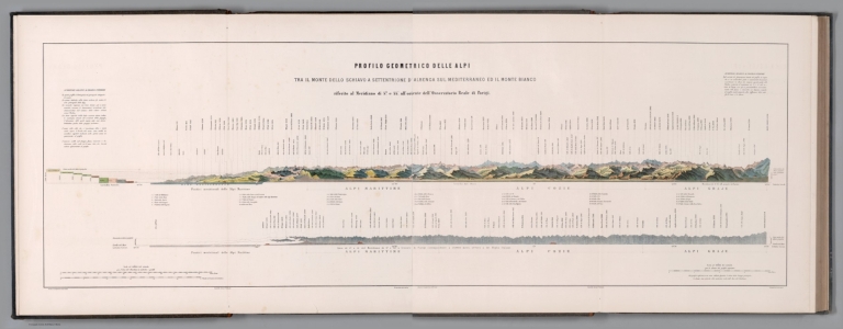
Composite Map: Profilo geometrico delle Alpi : Tra il Monte dello Schiavo a Settentrione d'Albenga sul Mediterraneo ed il Monte Bianco. Casa Edit. Dottor F. Vallardi.
List No
14396.009
Note
Composite of two-sheet profile view showing the Alps of Italy. Features different mountain ranges with peaks labeled. Relief shown with peak heights. Includes coordinate points, three bar scales and descriptive notes. Indexed to indicate valley names. Colored engraving. Map is 49 x 148 cm, on two double sheets, together 60 x 168 cm. Sheets appear consecutively. Within section entitled Il profilo geometrico delle Alpi.
Author
Vallardi, Francesco
Full Title
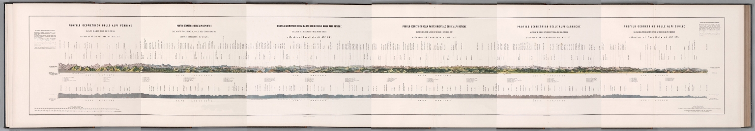
(Composite map of) Six profilo geometrico delle Alpi
List No
14396.098
Note
Composite of six profile views showing the Alps of Italy. Features different mountain ranges with peaks labeled. Relief shown with peak heights. Includes coordinate points, three bar scales and descriptive notes. Indexed to indicate valley names. Colored engraving. Within section entitled Il profilo geometrico delle Alpi.
Author
Imhof, Eduard, 1895-1986
Full Title
Die Grosse Windgellen, Südseite.
List No
15418.000
Author
Imhof, Eduard, 1895-1986
Full Title
Altmann im Säntisgebiet.
List No
15419.000
Author
Imhof, Eduard, 1895-1986
Full Title
Eiger und Mönch.
List No
15420.000
Author
Imhof, Eduard, 1895-1986
Full Title
Piz Bernina, Piz Scerscen, Piz Roseg from Fuorcla Sulaj
List No
15421.000
Author
[Heim, Albert, Imhof, Eduard, 1895-1986]
Full Title
BL I Rundsicht vom Gipfel des Santis. VIII Auflage. Revision und Reliefton von Prof. Ed. Imhof.
List No
15397.002
Author
[Heim, Albert, Imhof, Eduard, 1895-1986]
Full Title
BL II Rundsicht vom Gipfel des Santis. VIII Auflage. Revision und Reliefton von Prof. Ed. Imhof.
List No
15397.003
Author
[Heim, Albert, Imhof, Eduard, 1895-1986]
Full Title
BL III Rundsicht vom Gipfel des Santis. VIII Auflage. Revision und Reliefton von Prof. Ed. Imhof.
List No
15397.004
Author
[Heim, Albert, Imhof, Eduard, 1895-1986]
Full Title
BL IV Rundsicht vom Gipfel des Santis. VIII Auflage. Revision und Reliefton von Prof. Ed. Imhof.
List No
15397.005
Author
[Heim, Albert, Imhof, Eduard, 1895-1986]
Full Title
BL V Rundsicht vom Gipfel des Santis. VIII Auflage. Revision und Reliefton von Prof. Ed. Imhof.
List No
15397.006
Author
[Heim, Albert, Imhof, Eduard, 1895-1986]
Full Title
BL VI Rundsicht vom Gipfel des Santis. VIII Auflage. Revision und Reliefton von Prof. Ed. Imhof.
List No
15397.007
Author
[Heim, Albert, Imhof, Eduard, 1895-1986]
Full Title
(Composite view to) BL I - VI Rundsicht vom Gipfel des Santis. VIII Auflage. Revision und Reliefton von Prof. Ed. Imhof.
List No
15397.008
Author
Union de banques suisses
Full Title
Panorama du signal. Simplon S.A., Lausanne.
List No
14455.002
Note
Pictorial map of Lausanne, Switzerland. Shows railways, roads, buildings, parks, vegetation, bodies of water, drainage and shorelines. Features the Alps on the horizon, indexed to indicate peak names, with key above. With vignettes of statues in top left and right corners of sheet. Map indexed to indicate place names, with key in booklet preceding map. Colored lithograph. Map is 54 x 47 cm, on fold-out sheet 57 x 49 cm.
Author
Boyaciyan Agop Matbaasında
Full Title
(World map, mountains, volcanoes). Manissadjian & Co., Basle, Switzerland.
List No
13685.018
Note
Color map of the world principal mountains. Showing continents and oceans. Title provided by cataloger. Relief shown by hachures. Prime meridian: Greenwich.
Author
Boyaciyan Agop Matbaasında
Full Title
(World map of volcanoes). Manissadjian & Co., Basle, Switzerland.
List No
13685.021
Note
Color map of the world principal mountains and volcanoes. Title provided by cataloger. Relief shown by hachures. Prime meridian: Greenwich.
Author
[Baranov, Anatolij Nikolaevič, Soviet Union. Glavnoe upravlenie geodezii i kartografii]
Full Title
Северная италия, Свободная Территория Триест, Швейцария = Severnaia Italiia, Svobodnaia Territoriia Triyest, Shveytsariia. 115-116. Atlas Mira : 1954.
List No
13682.129
Note
Physical map of Northern Italy, Free Territory of Trieste and Switzerland. Showing political boundaries. Relief shown by gradient tints, contours and spot heights. Depth shown by bathymetric tints, isolines and soundings.
Author
[Darton, William, Butt, J., Mudge, William (1762-1820)]
Full Title
New and Improved View of the Principal Hill & Remarkable Eminences in England & Wales According to the Grand Trigonometrical Survey Made by Coln. Mudge.
List No
12295.002
Author
National Geographic Society
Full Title
The Quest for Everest
List No
15108.001
Note
Copyright National Geographic Society. For copies of this map see https://www.natgeomaps.com/
Author
National Geographic Society
Full Title
Mount Everest
List No
15109.001
Note
Copyright National Geographic Society. For copies of this map see https://www.natgeomaps.com/
Author
National Geographic Society
Full Title
High Himalaya A Computer-Generated Landscape Portrait
List No
15109.002
Note
Copyright National Geographic Society. For copies of this map see https://www.natgeomaps.com/
Author
National Geographic Society
Full Title
Everest
List No
15111.001
Note
Copyright National Geographic Society. For copies of this map see https://www.natgeomaps.com/
Author
National Geographic Society
Full Title
Everest 50
List No
15111.002
Note
Copyright National Geographic Society. For copies of this map see https://www.natgeomaps.com/
Author
[Schneider, E., Freytag - Berndt und Artaria]
Full Title
(Composite map of) Sheets 2-7 East Nepal
List No
15094.000
Author
[Schneider, E., Freytag - Berndt und Artaria]
Full Title
2. Khumbu Himal East Nepal
List No
15016.002
Author
[Schneider, E., Freytag - Berndt und Artaria]
Full Title
(Covers to) 3. Lapchi Kang East Nepal
List No
15017.001
Author
[Schneider, E., Freytag - Berndt und Artaria]
Full Title
3. Lapchi Kang East Nepal
List No
15017.002
Author
[Schneider, E., Freytag - Berndt und Artaria]
Full Title
4. Rolwaling Himal (Gaurisankar) East Nepal
List No
15093.002
Author
[Schneider, E., Freytag - Berndt und Artaria]
Full Title
5. Shorong / Hinku East Nepal
List No
15095.002
Author
[Schneider, E., Freytag - Berndt und Artaria]
Full Title
6. Tamba Kosi-Likhu Khola East Nepal
List No
15096.002
Author
[Schneider, E., Freytag - Berndt und Artaria]
Full Title
7. Dudh Kosi East Nepal
List No
15097.000
Author
Hitchcock, Edward, 1828-1911
Full Title
Outline of the geology of the globe. 1853. W. C. Sharp's Lith. Boston.
List No
2132.010
Note
Hand-colored, lithographed geologic world map. Shows the major mountain ranges, lakes, drainage and deserts, as well as geological forces and the different strata across the globe, including primary fossiliferous strata, alluvial deposits and volcanoes. Relief shown pictorially. Includes latitudinal and longitudinal lines, as well as a legend. With two inset maps: Supposed Antarctic Continent -- Comparative heights of continents & culminating points of mountains. First inset features Antarctic discoveries, with names of explorers and dates of voyages; second inset compares worldwide mountain elevations. Also, with a profile: [Mountain and volcano heights of the globe]. Map is 47 x 59 cm, on sheet 50 x 61 cm, folded to 20 x 11 cm. First of two maps in Hitchock's Geology of the globe.
Author
Giraud, Eugénie
Full Title
Montagnes de France.
List No
14321.007
Note
Manuscript map of France in ink and watercolor. Title translates to: Mountains of France. Shows international boundary, topography, drainage and coastline. Features specific mountain ranges, including the Pyrenees, Alps and Jura. Relief shown with hachures. Map is 17 x 26 cm, on sheet 21 x 31 cm. Accompanied by descriptive text on facing page and following four pages; title taken from text. Second map appearing in the first part of atlas, France : Ses montagnes -- Ses eaux [= France : Its mountains -- Its waters].
Author
Giraud, Eugénie
Full Title
Carte des vessants.
List No
14321.011
Note
Manuscript map of France in ink and watercolor. Title translates to: Map of vessants. Shows international boundary, topography, drainage and coastline. Features major physical divisions based upon mountain ranges. Relief shown with hachures. Map is 17 x 23 cm, on sheet 21 x 31 cm. Accompanied by descriptive text on facing page. Third map appearing in the first part of atlas, France : Ses montagnes -- Ses eaux [= France : Its mountains -- Its waters].
Author
[Perthes, Justus, Chile. Ministerio de Instrucción Pública., Fuenzalida, José del C.]
Full Title
Proyeccion vertical, vista panorámica : Entre Arica i Valle Sajama -- Proyeccion vertical, vista panorámica : Frente a Iquique.
List No
14325.003
Note
Two profile maps of the Arica, Sajama and Iquique areas in Chile. Titles translate to: Vertical projection, panoramic view : Between Arica and Sajama Valley -- Vertical projection, panoramic view : In front of Iquique. Maps show topography (including volcanoes), lakes, drainage and sea level, as well as the underwater slope. Mountain peaks featured, labeled with names and heights. Relief shown pictorially and with hacures. Maps each include coordinate points for latitude, as well as statements for both horizontal and vertical scale. Colored lithograph. Together, maps are 23 x 35 cm, on sheet 27 x 39 cm.
Author
[Perthes, Justus, Chile. Ministerio de Instrucción Pública., Fuenzalida, José del C.]
Full Title
Proyeccion vertical, vista panorámica : Altura de Quillagua -- Proyeccion vertical, vista panorámica : Frente a Antofagasta.
List No
14325.005
Note
Two profile maps of the Antofagasta and Quillagua areas in Chile. Titles translate to: Vertical projection, panoramic view : Quillagua height -- Vertical projection, panoramic view : In front of Antofagasta. Maps show topography (including volcanoes), lakes, drainage and sea level, as well as the underwater slope. Mountain peaks featured, labeled with names and heights. Relief shown pictorially and with hacures. Maps each include coordinate points for latitude, as well as statements for both horizontal and vertical scale. Colored lithograph. Together, maps are 23 x 35 cm, on sheet 27 x 39 cm.
Author
[Perthes, Justus, Chile. Ministerio de Instrucción Pública., Fuenzalida, José del C.]
Full Title
Proyeccion vertical, vista panorámica : Frente a Taltal -- Proyeccion vertical, vista panorámica : Frente a Copiapó.
List No
14325.008
Note
Two profile maps of the Taltal and Copiapó areas in Chile. Titles translate to: Vertical projection, panoramic view : In front of Taltal -- Vertical projection, panoramic view : In front of Copiapó. Maps show topography (including volcanoes), lakes, drainage and sea level, as well as the underwater slope. Mountain peaks featured, labeled with names and heights. Relief shown pictorially and with hacures. Maps each include coordinate points for latitude, as well as statements for both horizontal and vertical scale. Colored lithograph. Together, maps are 23 x 35 cm, on sheet 27 x 39 cm.
Author
[Perthes, Justus, Chile. Ministerio de Instrucción Pública., Fuenzalida, José del C.]
Full Title
Proyeccion vertical, vista panorámica : Entre Zapallar i el Aconcagua -- Proyeccion vertical, vista panorámica : Entre Carlajena, Santiago i Cerro Tupungato.
List No
14325.010
Note
Two profile maps of the Zapallar, Aconcagua, Carlajena and the Tupungato Volcano areas in Chile. Titles translate to: Vertical projection, panoramic view : Between Zapallar and Aconcagua -- Vertical projection, panoramic view : Between Carlajena, Santiago and Cerro Tupungato. Maps show topography (including volcanoes), lakes, drainage and sea level, as well as the underwater slope. Mountain peaks featured, labeled with names and heights. Relief shown pictorially and with hacures. Maps each include coordinate points for latitude, as well as statements for both horizontal and vertical scale. Colored lithograph. Together, maps are 23 x 35 cm, on sheet 27 x 39 cm.
Author
[Perthes, Justus, Chile. Ministerio de Instrucción Pública., Fuenzalida, José del C.]
Full Title
Proyeccion vertical, vista panorámica -- Proyeccion vertical, vista panorámica : Frente a Temuco.
List No
14325.013
Note
Two profile maps of the Temuco area in Chile. Titles translate to: Vertical projection, panoramic view -- Vertical projection, panoramic view : In front of Temuco. Maps show topography (including volcanoes), lakes, drainage and sea level, as well as the underwater slope. Mountain peaks featured, labeled with names and heights. Relief shown pictorially and with hacures. Maps each include coordinate points for latitude, as well as statements for both horizontal and vertical scale. Colored lithograph. Together, maps are 23 x 35 cm, on sheet 27 x 39 cm.
Author
[Perthes, Justus, Chile. Ministerio de Instrucción Pública., Fuenzalida, José del C.]
Full Title
Proyeccion vertical, vista panorámica -- Proyeccion vertical, vista panorámica : Frente a Castro.
List No
14325.015
Note
Two profile maps of the Castro area in Chile. Titles translate to: Vertical projection, panoramic view -- Vertical projection, panoramic view : In front of Castro. Maps show topography (including volcanoes), lakes, drainage and sea level, as well as the underwater slope. Mountain peaks featured, labeled with names and heights. Relief shown pictorially and with hacures. Maps each include coordinate points for latitude, as well as statements for both horizontal and vertical scale. Colored lithograph. Together, maps are 23 x 35 cm, on sheet 27 x 39 cm.
Author
[Imhof, Eduard, Institut Orell Fussli AG]
Full Title
Reisekarte Von Graubunden. Carte De Voyage Des Grisons. Tourist Map of the Grisons.
List No
10509.003
|

![Panorama du Pilate prise sur l' Esel, 6532' au dessus de la mer. [Panorama of Pilate taken on the Esel, 6532' above the sea.]](https://media.davidrumsey.com/MediaManager/srvr?mediafile=/Size4/RUMSEY~8~1/205/15719001.jpg)