|
Full Title
Manufactures, mechanics and mining. Based on returns of the tenth census. Copyright, 1883, by Charles Scribner's Sons.
List No
4521.068
Note
Color lithographed map and 3 graphs. "Occupations."
Full Title
Gold. Mining regions ... (map) Product per capita, by states. Copyright, 1883, by Charles Scribner's Sons.
List No
4521.140
Note
Color lithographed map with 5 charts. Charts: Gold product, per capita, by states, 1880 -- Total gold product, by states, 1880 -- Gold and silver product of the world, 1880 -- Gold and silver deposited at the mints and assay offices, from their organization to June 30, 1880 -- Estimated gold and silver product of the United States, 1845-1880. "Mining."
Full Title
Silver. Mining regions ... Copper. Mining regions ... Product per capita by states. Based on the returns of the tenth census. 1880. Copyright, 1883, by Charles Scribner's Sons.
List No
4521.141
Note
Two color lithographed maps with 5 charts. Charts: Silver: total product, 1880; Product per capita, 1880 -- Copper: Product per capita, 1880; Total product, value, 1880; Total product, ingots, 1880. "Mining."
Full Title
Coal. Mining regions ... (map) Product per capita, by states. Based on the returns of the tenth census. 1880. Copyright, 1883, by Charles Scribner's Sons.
List No
4521.142
Note
Color lithographed map with 5 charts. Charts: Total product, 1880 -- Product per capita, value, 1880 -- Total out-put of coal in 1880 -- Total out-put of anthracite coal, 1820-1880 -- Price-chart of anthracite coal for 56 years, 1825 (to) 1880. Includes table. "Mining."
Full Title
Iron ore. Mining regions ... Product per capita, by states. Based on the returns of the tenth census. 1880. (with) Lead ore. Mining regions. Product per capita. 1880. (with) Salt. Producing regions. Product per capita. 1880. Copyright, 1883, by Charles Scribner's Sons.
List No
4521.143
Note
Color lithographed map with 2 ancillary maps and 6 charts. Charts show total product, value, 1880 and product per capita, value, 1880. Includes table of authorities. "Mining."
Author
Hayden, F.V.
Full Title
Economic Map of Colorado. Department of the Interior, U.S. Geological and Geographical Survey of the Territories, F.V. Hayden, U.S. Geologist in Charge. Sheet III.
List No
4576.003
Note
Map in full color showing agricultural, pasture, sage and "bad" lands. Pine forests, cedars and quaking aspen groves are shown. The gold and silver districts are noted.
Author
Becker, George F.
Full Title
(Title Page to) Department Of The Interior, United States Geological Survey, J.W. Powell Director. Atlas to Accompany a Monograph on The Geology of the Quicksilver Deposits of the Pacific Slope By George F. Becker. Washington 1887. Giles Litho. & Liberty Printing Co. N.Y.
List No
4580B
Author
Becker, George F.
Full Title
(Table of Contents to) Department Of The Interior, United States Geological Survey, J.W. Powell Director. Atlas to Accompany a Monograph an The Geology of the Quicksilver Deposits of the Pacific Slope By George F. Becker. Washington 1887. Giles Litho. & Liberty Printing Co. N.Y.
List No
4580C
Author
Becker, George F.
Full Title
Geological Map of the Sulphur Bank District. U.S. Geological Survey. Monograph XIII, Atlas Sheet IV. S.H. Bodfish 1882, J.D. Hoffman 1884, Topographers. Giles Litho. & Liberty Printing Co. Geo. F. Becker, Geologist in charge.
List No
4580.002
Note
Shows in color three classes of rock. Relief shown by 20-foot contour lines. Shows mines, streams, and settlements.
Author
Becker, George F.
Full Title
Geological Map of the Knoxville District. U.S. Geological Survey. Monograph XIII, Atlas Sheet V. Topography by J.D. Hoffman 1883. Geo. F. Becker, Geologist in charge. Topographical Map of the Region of Clear Lake. Compiled by C.F. Hoffmann. Geo. F. Becker, Geologist in charge.
List No
4580.003
Note
Two maps on one sheet. Knoxville District map relief shown with 25-foot contours. Shows in color five classes of rock. Longitude and latitude shown. Scale 1:15,000. Clear Lake Region map shows topography with shaded relief, streams, mines, settlements, and roads. Scale 1:95,000. Outlines of Sulphur Bank District and Knoxville District shown.
Author
Becker, George F.
Full Title
Geological Map of the New Idria District. U.S. Geological Survey. Monograph XIII, Atlas Sheet VI. J.D. Hoffman, Topographer. Giles Litho. & Liberty Printing Co. N.Y. Geo. F. Becker, Geologist in charge.
List No
4580.004
Note
Shows in color three classes of rock. Relief shown by 40-foot contour lines. Shows streams, settlements, mines, trails, and roads.
Author
Becker, George F.
Full Title
Geological Map of the New Almaden Mining District. U.S. Geological Survey. Monograph XIII, Atlas Sheet VII. Topography by S.W. Bodfish and others. Giles Litho. & Liberty Printing Co. N.Y. Geo. F. Becker, Geologist in charge.
List No
4580.005
Note
Shows in color six classes of rock. Relief shown by 20-foot contour lines. Shows streams, settlements, mines, and roads.
Author
Becker, George F.
Full Title
Ore-Bodies and Topography of Mine-Hill, New Almaden. U.S. Geological Survey. Monograph XIII, Atlas Sheet VIII. Compiled by F. Reade 1885. Giles Litho. & Liberty Printing Co. N.Y. Geo. F. Becker, Geologist in charge.
List No
4580.006
Note
Shows in topography with 10-foot contours, ore bodies with cross-hatching, mine dumps with hachures, +streams, roads, tramways, tunnels and shafts.
Author
Becker, George F.
Full Title
Plan of the New Almaden Mine. U.S. Geological Survey. Monograph XIII, Atlas Sheet IX. Compiled by F. Reade 1885. Giles Litho. & Liberty Printing Co. N.Y. Geo. F. Becker, Geologist in charge.
List No
4580.007
Note
Shows depths, tunnels, drifts, galleries, and shafts in brilliant color.
Author
Becker, George F.
Full Title
Longitudinal Section of the South Ore Channel. New Almaden Mine. U.S. Geological Survey. Monograph XIII, Atlas Sheet X. Compiled by F. Reade 1885. Giles Litho. & Liberty Printing Co. N.Y. Geo. F. Becker, Geologist in charge.
List No
4580.008
Note
Shows depths, tunnels, drifts, galleries, and shafts.
Author
Becker, George F.
Full Title
North and South Section , 550 Feet West of Randol Shaft, New Almaden Mine. North and South Section through the Randol Shaft, New Almaden Mine. U.S. Geological Survey. Monograph XIII, Atlas Sheet XI. Compiled by F. Reade 1885. Geo. F. Becker, Geologist in charge.
List No
4580.009
Note
Two vertical sections on one sheet. Shows depths, tunnels, drifts, galleries, and shafts.
Author
Becker, George F.
Full Title
East and West Vertical Section, New Almaden Mine. U.S. Geological Survey. Monograph XIII, Atlas Sheet XII. Compiled by F. Reade 1885. Geo. F. Becker, Geologist in charge.
List No
4580.010
Note
Shows depths, tunnels, drifts, galleries, and shafts.
Author
Becker, George F.
Full Title
Plan of the Clay Walls, New Almaden Mine. U.S. Geological Survey. Monograph XIII, Atlas Sheet XIII. Compiled by F. Reade 1885. Giles Litho. & Liberty Printing Co. N.Y. Geo. F. Becker, Geologist in charge.
List No
4580.011
Note
Shows alignments of clay walls.
Author
Becker, George F.
Full Title
Steam-Boat Springs, Nevada. U.S. Geological Survey. Monograph XIII, Atlas Sheet XIV. Topography by Eugene Ricksecker, 1885. Giles Litho. & Liberty Printing Co. N.Y. Geo. F. Becker, Geologist in charge.
List No
4580.012
Note
Topography shown by 20-foot contours. Ten classes of rocks shown in color. Streams, structures, railroads, roads, and benchmarks shown.
Author
Church, A. F. (Ambrose F.)
Full Title
Church's mineral map of Nova Scotia. Shewing by symbols the outcrop of the known coal seams, gold-bearing quartz-veins and ore-beds, containing mineral of economic value and importance. Published by A.F. Church & Co., Bedford, Halifax County. [Entered ... 1889, by Ambrose F. Church, of Bedford, Nova Scotia, at the Department of Agriculture.] Canada Bank Note Co. Lim., Photo-Lith., Montreal.
List No
4637.000
Note
Shows the height of coal and gold interest in Nova Scotia. A scarce map not in any listings. Extensive notes on the minerals of Nova Scotia. The printing process is color lithography, and very well done by the Canada Bank Note Co. of Montreal. Maps has pink cloth edging, marbled end sheets, and is dissected into 24 sections. Folds into a new dark blue cloth folding case 32x26.5 with "Mineral Map Of Nova Scotia A.F. Church 1889" stamped in gold on the spine. Full color.
Author
Cram, George Franklin
Full Title
(Statistical Diagrams of production by state for corn, orchard products, wheat, gold, and silver.)
List No
4727.133
Note
With printed color.
Author
Clouet, J. B. L. (Jean-Baptiste Louis), b. 1730
Full Title
La France mineralogique. (1787)
List No
4757.027
Note
Abbot Jean Baptiste Louis Clouet (c. 1730 – 1790) was a French cartographer active in the mid to late 18th century. Clouet held the post of Royal Geographer of the Academie des Sciences de Rouen, he had offices in Paris and Cadiz. Clouet’s most important work is his Geographie Moderne, which was published in various editions from 1776 – 1793. Clouet also produced a series of stunning and highly decorative wall maps depicting the various continents. He followed in the footsteps of Jean-Baptiste Nolin and other French cartographers, reissuing these grand wall-maps in the latter part of the 18th century to decorate the houses of Paris and more unusually Spain.
Author
Dussieux, L.
Full Title
65. 1er. Croquis d'une Carte Mineralogique de la France, 1853. 66. Croquis d'une Carte Eaux Minerales de la France.
List No
4759.065
Author
Dussieux, L.
Full Title
67. 2e. Croquis d'une Carte Mineralogique de la France, Indiquant les principaux gisements des mineraux usuels (Exploitation des Carrieres). 9 Juin 1853.
List No
4759.066
Author
Rand McNally and Company
Full Title
(Covers to) Rand, McNally & Co.'s new geological map of Colorado. Copyright, 1879, by Rand, McNally & Co.
List No
4788A
Note
This is a very unusual map for Rand McNally to issue - geological maps were not common in their catalog and this may be the only one they published. It was probably the interest in mining that motivated publication and the inclusion of "Mineralogical References" in the map key. The main source for the geological formations was Hayden's General Geological Map of Colorado that appeared in his 1877 Atlas of Colorado. But Rand McNally's map has much more detail on towns and railroads than Hayden and is a much superior map in that respect. Ellis 82 is the 1880 edition, which was also issued without geological coloring as "Rand McNally & Co.'s New Sectional Map of Colorado." This map is in printed full color, folded into dark blue cloth covers 16.5x10 titled "Rand, McNally & Co's geological and mineralogical maps Of Colorado" in gold.
Author
Rand McNally and Company
Full Title
Rand, McNally & Co.'s new geological map of Colorado. Copyright, 1879, by Rand, McNally & Co.
List No
4788.001
Note
This is a very unusual map for Rand McNally to issue - geological maps were not common in their catalog and this may be the only one they published. It was probably the interest in mining that motivated publication and the inclusion of "Mineralogical References" in the map key. The main source for the geological formations was Hayden's General Geological Map of Colorado that appeared in his 1877 Atlas of Colorado. But Rand McNally's map has much more detail on towns and railroads than Hayden and is a much superior map in that respect. Ellis 82 is the 1880 edition, which was also issued without geological coloring as "Rand McNally & Co.'s New Sectional Map of Colorado." This map is in printed full color, folded into dark blue cloth covers 16.5x10 titled "Rand, McNally & Co's geological and mineralogical maps Of Colorado" in gold.
Author
Meyer, Joseph, 1796-1856
Full Title
Neueste Karte von Nord Carolina mit seinen Canaelen, Strassen, Eisenbahnen, Entfernungen der Hauptpunkte und Routen fur Dampfschiffe. Nach den bessten Quellen verbessert. 1845. (with Der Neuse Fluss). (with) Gold Region. (with) Profil des Dismal Swamp Canals. Aus der Graviranstalt des Bibliographischen Instituts zu Hildburghausen, Amsterdam, Paris u. Philadelphia, (1860)
List No
4807.149
Note
Engraved map. State boundaries hand col. Relief shown by hachures. Includes distance table. "Meyer's Handatlas No. 78." Prime meridians: Ferro and Washington.
Author
Meyer, Joseph, 1796-1856
Full Title
Neueste Karte von Illinois mit seinen Strassen, Entfernung, der Hauptpunkte und Routen fur Dampfschiffe. Nach den bessten Quellen verbessert. 1845. (with) Lead-, Bley- Region. Aus der Geographischen Graviranstalt des Bibliographischen Instituts zu Hildburghausen, Amsterdam, Paris u. Philadelphia, (1860)
List No
4807.159
Note
Engraved map. State boundaries hand col. Includes distance tables. Inset shows mines, mills, etc. in northwestern Illinois and southwestern Huron District (Wisconsin). "Meyer's Handatlas No. 70." Prime meridians: Ferro and Washington.
Author
Johnson, Alvin Jewett, 1827-1884.
Full Title
Johnson's World, Showing the Distribution of the Characteristic Forest Trees, Principal Useful Plants and Minerals. By Prof. A. Guyot. Published by A.J. Johnson & Son New york. Entered ... 1870, by A.J. Johnson ... New York. (to accompany) Johnson's New Illustrated Family Atlas Of The World ... MDCCCLXXX (1880). (insets) Useful metals. (with) Coal.
List No
4830.060
Note
Engraved world map, with 2 insets. Showing the distribution of plants and minerals over the globe. Include notes.
Author
[Colton, J. H., Warren, Gouverneur Kemble, 1830-1882, Redpath, James, Hinton, Richard J]
Full Title
(Covers to) Hand Book To Kansas Territory And The Rocky Mountains' Gold Region; Accompanied By Reliable Maps and a Preliminary Treatise on the Pre-emption Laws of the United States. By James Redpath and Richard J. Hinton, of Kansas. New York: J.H. Colton, Publisher, 172 William Street. 1859. (on verso) Entered ... in the year 1859, (Published) by J.H. Colton ... New York.
List No
4872.001
Note
An important early guide to the Colorado Gold Region, with three Colton maps on two sheets: "Kansas and Nebraska...1859," which is taken from the 1858 General Atlas, minus the upper half of Nebraska - shows eastern Kansas and Nebraska; "Nebraska and Kanzas, Showing Pikes Peak And The Gold Region...1859," which is the lower half of the 1857 General Atlas map of the same title (without the reference to the Gold Region); and "Military Map of Parts of Kansas, Nebraska and Dakota by Lieut. G.K. Warren Top. Engrs. from the Explorations made by him in 1855, 56 & 57... J.H. Colton... New York," which is derived from the lower half of Warren's 1858/1859 "Military Map of Nebraska and Dakota" (see our #2932). The "Nebraska and Kanzas, Showing Pikes Peak..." map appeared as the only map in J.W. Reed's 1859 "Map of and Guide to the Kansas Gold Region (WC343a), also published by J.H. Colton. Bound in brown linen 15x10, with "Guide to Kansas, The Pike's Peak Gold Region &c. &c. J.H. Colton New York" in gold on the cover. Prime meridians are Washington D.C. and Greenwich.
Author
[Colton, J. H., Warren, Gouverneur Kemble, 1830-1882, Redpath, James, Hinton, Richard J]
Full Title
Catalog) Hand Book To Kansas Territory And The Rocky Mountains' Gold Region; Accompanied By Reliable Maps and a Preliminary Treatise on the Pre-emption Laws of the United States. By James Redpath and Richard J. Hinton, of Kansas. New York: J.H. Colton, Publisher, 172 William Street. 1859. (on verso) Entered ... in the year 1859, (Published) by J.H. Colton ... New York.
List No
4872.002
Note
An important early guide to the Colorado Gold Region, with three Colton maps on two sheets: "Kansas and Nebraska...1859," which is taken from the 1858 General Atlas, minus the upper half of Nebraska - shows eastern Kansas and Nebraska; "Nebraska and Kanzas, Showing Pikes Peak And The Gold Region...1859," which is the lower half of the 1857 General Atlas map of the same title (without the reference to the Gold Region); and "Military Map of Parts of Kansas, Nebraska and Dakota by Lieut. G.K. Warren Top. Engrs. from the Explorations made by him in 1855, 56 & 57... J.H. Colton... New York," which is derived from the lower half of Warren's 1858/1859 "Military Map of Nebraska and Dakota" (see our #2932). The "Nebraska and Kanzas, Showing Pikes Peak..." map appeared as the only map in J.W. Reed's 1859 "Map of and Guide to the Kansas Gold Region (WC343a), also published by J.H. Colton. Bound in brown linen 15x10, with "Guide to Kansas, The Pike's Peak Gold Region &c. &c. J.H. Colton New York" in gold on the cover. Prime meridians are Washington D.C. and Greenwich.
Author
[Colton, J. H., Warren, Gouverneur Kemble, 1830-1882, Redpath, James, Hinton, Richard J]
Full Title
(Title Page to) Hand Book To Kansas Territory And The Rocky Mountains' Gold Region; Accompanied By Reliable Maps and a Preliminary Treatise on the Pre-emption Laws of the United States. By James Redpath and Richard J. Hinton, of Kansas. New York: J.H. Colton, Publisher, 172 William Street. 1859. (on verso) Entered ... in the year 1859, (Published) by J.H. Colton ... New York.
List No
4872.003
Note
An important early guide to the Colorado Gold Region, with three Colton maps on two sheets: "Kansas and Nebraska...1859," which is taken from the 1858 General Atlas, minus the upper half of Nebraska - shows eastern Kansas and Nebraska; "Nebraska and Kanzas, Showing Pikes Peak And The Gold Region...1859," which is the lower half of the 1857 General Atlas map of the same title (without the reference to the Gold Region); and "Military Map of Parts of Kansas, Nebraska and Dakota by Lieut. G.K. Warren Top. Engrs. from the Explorations made by him in 1855, 56 & 57... J.H. Colton... New York," which is derived from the lower half of Warren's 1858/1859 "Military Map of Nebraska and Dakota" (see our #2932). The "Nebraska and Kanzas, Showing Pikes Peak..." map appeared as the only map in J.W. Reed's 1859 "Map of and Guide to the Kansas Gold Region (WC343a), also published by J.H. Colton. Bound in brown linen 15x10, with "Guide to Kansas, The Pike's Peak Gold Region &c. &c. J.H. Colton New York" in gold on the cover. Prime meridians are Washington D.C. and Greenwich.
Author
[Colton, J. H., Warren, Gouverneur Kemble, 1830-1882, Redpath, James, Hinton, Richard J]
Full Title
Kansas and Nebraska. 1859. (inset map) Nebraska and Kansas, Showing Pikes Peak And The Gold Region. 1859. (Published) by J.H. Colton & Co., 172 William St., New York.
List No
4872.004
Note
An important early guide to the Colorado Gold Region, with three Colton maps on two sheets: "Kansas and Nebraska...1859," which is taken from the 1858 General Atlas, minus the upper half of Nebraska - shows eastern Kansas and Nebraska; "Nebraska and Kanzas, Showing Pikes Peak And The Gold Region...1859," which is the lower half of the 1857 General Atlas map of the same title (without the reference to the Gold Region); and "Military Map of Parts of Kansas, Nebraska and Dakota by Lieut. G.K. Warren Top. Engrs. from the Explorations made by him in 1855, 56 & 57... J.H. Colton... New York," which is derived from the lower half of Warren's 1858/1859 "Military Map of Nebraska and Dakota" (see our #2932). The "Nebraska and Kanzas, Showing Pikes Peak..." map appeared as the only map in J.W. Reed's 1859 "Map of and Guide to the Kansas Gold Region (WC343a), also published by J.H. Colton. Bound in brown linen 15x10, with "Guide to Kansas, The Pike's Peak Gold Region &c. &c. J.H. Colton New York" in gold on the cover. Prime meridians are Washington D.C. and Greenwich.
Author
[Colton, J. H., Warren, Gouverneur Kemble, 1830-1882, Redpath, James, Hinton, Richard J]
Full Title
Military Map of Parts of Kansas, Nebraska and Dakota. By Lieut. G.K. Warren Top. Engrs. from the Explorations made by him in 1855, 56 & 57. (Published) by J.H. Colton & Co., 172 William St., New York.
List No
4872.005
Note
An important early guide to the Colorado Gold Region, with three Colton maps on two sheets: "Kansas and Nebraska...1859," which is taken from the 1858 General Atlas, minus the upper half of Nebraska - shows eastern Kansas and Nebraska; "Nebraska and Kanzas, Showing Pikes Peak And The Gold Region...1859," which is the lower half of the 1857 General Atlas map of the same title (without the reference to the Gold Region); and "Military Map of Parts of Kansas, Nebraska and Dakota by Lieut. G.K. Warren Top. Engrs. from the Explorations made by him in 1855, 56 & 57... J.H. Colton... New York," which is derived from the lower half of Warren's 1858/1859 "Military Map of Nebraska and Dakota" (see our #2932). The "Nebraska and Kanzas, Showing Pikes Peak..." map appeared as the only map in J.W. Reed's 1859 "Map of and Guide to the Kansas Gold Region (WC343a), also published by J.H. Colton. Bound in brown linen 15x10, with "Guide to Kansas, The Pike's Peak Gold Region &c. &c. J.H. Colton New York" in gold on the cover. Prime meridians are Washington D.C. and Greenwich.
Author
[Strauch, Geo. B., Cochran, A.B.]
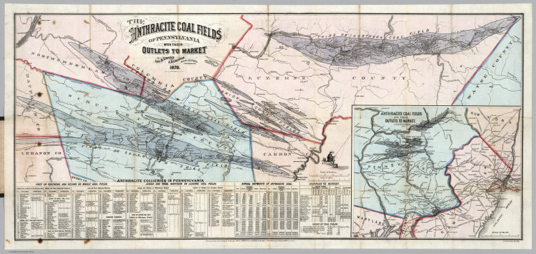
Full Title
(Covers to) The Anthracite Coal Fields Of Pennsylvania With Their Outlets To Market. By Geo. B. Strauch And A.B. Cochran, Mining Engineers, Pottsville, Pa. 1878. Entered ... 1878 by Strauch & Cochran ... Washington D.C. T. Sinclair & Son. lith. Phila. (inset) Anthracite Coal Fields And Their Outlets To Market. Strauch & Cochran 1878
List No
4904.001
Note
Shows the four major coal fields of Eastern Pennsylvania, with an inset map on a smaller scale showing the market outlets to New York, Baltimore and Philadelphia. There is a list of 291 Anthracite Collieries operating in the coal fields, statistics on annual shipments of anthracite coal, list of distances to market, and areas of coal fields. Folded into dark brown cloth covers 15.5x10 with "Anthracite Coal Fields Of Pennsylvania Strauch & Cochran 1878" stamped in gilt.
Author
[Strauch, Geo. B., Cochran, A.B.]
Full Title
The Anthracite Coal Fields Of Pennsylvania With Their Outlets To Market. By Geo. B. Strauch And A.B. Cochran, Mining Engineers, Pottsville, Pa. 1878. Entered ... 1878 by Strauch & Cochran ... Washington D.C. T. Sinclair & Son. lith. Phila. (inset) Anthracite Coal Fields And Their Outlets To Market. Strauch & Cochran 1878
List No
4904.002
Note
Color map. Shows the four major coal fields of Eastern Pennsylvania, with an inset map on a smaller scale showing the market outlets to New York, Baltimore and Philadelphia. There is a list of 291 Anthracite Collieries operating in the coal fields, statistics on annual shipments of anthracite coal, list of distances to market, and areas of coal fields.
Author
[Colton, G. W. & C. B., Swann, John S.]
Full Title
(Covers to) Title Map of the Coal Field Of The Great Kanawha Valley West Virginia, United States of America. By John S. Swann, Attorney at Law, Charleston, Kanawha County W. Va. Engraved, Printed, And Manufactured By G.W. & C.B. Colton & Co. No. 172 Williams St New York. Price of Map $10.00 To Be Procured Of Thomas L. Broun ... and John S. Swann ... Entered ... 1867, by John S. Swann ... Charleston, West Virginia. (inset) West Virginia Showing the rail and water communication Between The Great Kanawha District And Pittsburgh & Cincinnati.
List No
4965A
Note
Huge, large scale map of one of the early and important coal regions of West Virginia. Land owners' holdings are shown in color with dates of original patents (George Washington had large holdings here). Six sections show the amount and kinds of coal found at different parts of the valley. An inset map of West Virginia shows the current and future water and rail connections between the Kanawha Valley and Pittsburgh and Cincinnati. Several columns of text describe the geography, climate, and types of coal to be found. The sheer amount of information is impressive. This must be one of the best coal mining maps of its time, if not the largest. Map folds into embossed dark brown cloth covers 22x15 with "Title Map Of The Great Kanawha Coal Field. John S. Swann." in gilt.
Author
[Colton, G. W. & C. B., Swann, John S.]
Full Title
Title Map of the Coal Field Of The Great Kanawha Valley West Virginia, United States of America. By John S. Swann, Attorney at Law, Charleston, Kanawha County W. Va. Engraved, Printed, And Manufactured By G.W. & C.B. Colton & Co. No. 172 Williams St New York. Price of Map $10.00 To Be Procured Of Thomas L. Broun ... and John S. Swann ... Entered ... 1867, by John S. Swann ... Charleston, West Virginia. (inset) West Virginia Showing the rail and water communication Between The Great Kanawha District And Pittsburgh & Cincinnati.
List No
4965.001
Note
Huge, large scale map of one of the early and important coal regions of West Virginia. Land owners' holdings are shown in color with dates of original patents (George Washington had large holdings here). Six sections show the amount and kinds of coal found at different parts of the valley. An inset map of West Virginia shows the current and future water and rail connections between the Kanawha Valley and Pittsburgh and Cincinnati. Several columns of text describe the geography, climate, and types of coal to be found. The sheer amount of information is impressive. This must be one of the best coal mining maps of its time, if not the largest. Map folds into embossed dark brown cloth covers 22x15 with "Title Map Of The Great Kanawha Coal Field. John S. Swann." in gilt.
Author
[Smith, J.L., Smith, A. DW.]
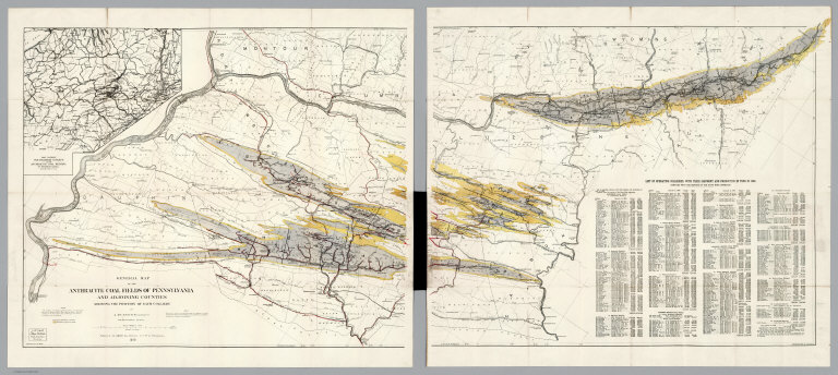
Full Title
(Covers to) General Map Of The Anthracite Coal Fields Of Pennsylvania And Adjoining Counties Showing The Position Of Each Colliery. By A. DW. Smith, Mining Engineer. Wilkes-Barre, Penna. Published by J.L. Smith, Map Publisher, 27 S. 6th St., Philadelphia 1899. Copyrighted 1899 By A. DW. Smith. (inset) Map Showing The Railroad Outlets Of The Anthracite Coal Regions Of Pennsylvania.
List No
5069.001
Note
Late, detailed map of the Pennsylvania coal fields; folded into dark brown cloth covers 19x11 with "Anthracite Coal Fields Of Pennsylvania J.L. Smith 1899" in gilt. On the map is a note: "This map is a revised copy of the 'General Map of the Anthracite Coal Fields' published by the Pennsylvania Geological Survey in 1890; and is republished by permission of the Board of Commissioners."
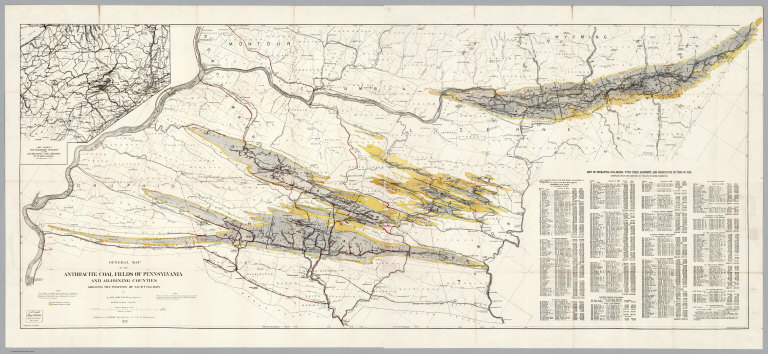
Author
[Smith, J.L., Smith, A. DW.]
Full Title
General Map Of The Anthracite Coal Fields Of Pennsylvania And Adjoining Counties Showing The Position Of Each Colliery. By A. DW. Smith, Mining Engineer. Wilkes-Barre, Penna. Published by J.L. Smith, Map Publisher, 27 S. 6th St., Philadelphia 1899. Copyrighted 1899 By A. DW. Smith. (inset) Map Showing The Railroad Outlets Of The Anthracite Coal Regions Of Pennsylvania.
List No
5069.002
Note
Late, detailed map of the Pennsylvania coal fields. On the map is a note: "This map is a revised copy of the 'General Map of the Anthracite Coal Fields' published by the Pennsylvania Geological Survey in 1890; and is republished by permission of the Board of Commissioners." Includes a "List of operating collieries, with their shipment and production in Tons in 1898". Prime meridian is Washington.
Author
[Smith, J.L., Smith, A. DW.]
Full Title
(Composite of) General Map Of The Anthracite Coal Fields Of Pennsylvania And Adjoining Counties Showing The Position Of Each Colliery. By A. DW. Smith, Mining Engineer. Wilkes-Barre, Penna. Published by J.L. Smith, Map Publisher, 27 S. 6th St., Philadelphia 1899. Copyrighted 1899 By A. DW. Smith. (inset) Map Showing The Railroad Outlets Of The Anthracite Coal Regions Of Pennsylvania.
List No
5069.003
Note
Late, detailed map of the Pennsylvania coal fields. On the map is a note: "This map is a revised copy of the 'General Map of the Anthracite Coal Fields' published by the Pennsylvania Geological Survey in 1890; and is republished by permission of the Board of Commissioners." Includes a "List of operating collieries, with their shipment and production in Tons in 1898". Prime meridian is Washington.
Author
[Gibbes, C.D., Holt, Warren]
Full Title
Map of the States Of California And Nevada. Carefully Compiled from the Latest Authentic Sources. By Chas. Drayton Gibbes, C.E. Comprising Information obtained from the U.S. Coast And Land Surveys ... And Others. Published by Warren Holt. No. 607 Clay Street, San Francisco, Cal. 1873. Entered ... 1873 by Warren Holt ... Washington. S. Blinton Formerly of the U.S. Coast Survey Draughtsman & Lithographer. 148-1/2 S. Fourth Street, Philadelphia, Pa.
List No
5154.001
Note
First edition, second state. Shows mineral deposits by color. Lineal descendent of the 1869 larger map of California and Nevada by Holt, Gibbes, and others. Also shows 10, 20 and 30 mile railroad grants. This is not the first state of the first edition - that has 11 land districts instead of the 14 found on this copy (see our #5154). The "unexplored" area in the Northeastern corner of California has been removed with much topographical detail changed from the first state. Eureka County is added in Nevada. The change of the Land Districts from eleven to fourteen includes a radical change in boundaries, some names changed, and numbering changed, indicating a major restructuring of the General Land Office administration in 1873. Map is folded into red cloth covers 16x10 with "Holt's Map Of California And Nevada." in gilt.
Author
Lapham, I.A.
Full Title
(Covers to) Wisconsin, a Sectional Map With the Most Recent Surveys, by I.A. Lapham, 1846. Scale, 10 miles to an inch. Published by P.C. Hale, Milwaukee, Wisconsin. J.H. Bufford & Cos Lithog Boston. Entered ... 1846 by P.C. Hale ... Territory of Wisconsin.
List No
5208.001
Note
First edition, with Karrow showing later editions in 1849, 1850 and 1851. Eberstadt calls this "perhaps the earliest large scale separately printed sectional map of the Territory." Copper and Lead mines are shown in the area around Mineral Point and counties are colored blue in outline. This is probably Lapham's first published state map - the map he used in his 1844 "Geographical and Topographical Description of Wisconsin" is by Morse and Breese (see our #3077). His earliest city map is the 1845 "Map of Milwaukee" engraved by Sherman and Smith (although Karrow attributes to Lapham the 1836 "City of Milwaukee" by William Burt). Backed on thin linen and folded into dark brown leather covers 14x9, with "Wisconsin." stamped in gilt on the front cover.
Author
Lapham, I.A.
Full Title
Wisconsin, a Sectional Map With the Most Recent Surveys, by I.A. Lapham, 1846. Scale, 10 miles to an inch. Published by P.C. Hale, Milwaukee, Wisconsin. J.H. Bufford & Cos Lithog Boston. Entered ... 1846 by P.C. Hale ... Territory of Wisconsin.
List No
5208.002
Note
First edition, with Karrow showing later editions in 1849, 1850 and 1851. Eberstadt calls this "perhaps the earliest large scale separately printed sectional map of the Territory." Copper and Lead mines are shown in the area around Mineral Point and counties are colored blue in outline. This is probably Lapham's first published state map - the map he used in his 1844 "Geographical and Topographical Description of Wisconsin" is by Morse and Breese (see our #3077). His earliest city map is the 1845 "Map of Milwaukee" engraved by Sherman and Smith (although Karrow attributes to Lapham the 1836 "City of Milwaukee" by William Burt). Backed on thin linen and folded into dark brown leather covers 14x9, with "Wisconsin." stamped in gilt on the front cover.
Author
Wescoatt, N.
Full Title
Map Of Gold Hill Front Lodes On The Comstock Range N.T. Surveyed July 1864. By N. Wescoatt, C.E. Located Sept. & Oct. 1859. Made to accompany Report of Dr. J.A. Veatch. Attenh. N. Wescoatt. C.E. Oakley & Tompson Lith. 46 Water St. Boston.
List No
5297.000
Note
Map is without color. Shows locations of tunnels and mine shafts. Relief shown by hachures. Scale 375 ft. to 1 in.
Author
Stanford's Geographical Establishment
Full Title
Topographical Map Showing the Locations of the Sutro Tunnel And The Comstock Lode State Of Nevada, United States Of America. Reduced and Compiled from U. States Govt. Surveys &c. at Stanford's Geographical Estabt. London, June, 1873. (with) Profile Of Sutro Tunnel ... Lithographed at Stanford's Geogl. Estabt., London. (with) Longitudinal Section Of The Comstock Lode, Shewing The Workings And Their Relative Depths, To The Sutro Tunnel.
List No
5303.001
Note
Color map measuring 42x32.5, with two profiles on one sheet. Relief shown by contour lines.
Author
Read, T.J.
Full Title
Map Of The Golden Rule And Adjacent Mines, Eureka District, Nevada. Drawn By T.J. Read, Supt. Eureka Con. & Deputy U.S. Surveyer. Empire Lith. & Engr. Co. 243-247 Pearl St. N.Y.
List No
5316.000
Note
The Golden Rule Mines are tinted pink and labeled "Golden Rule" Shows boundaries of mining claims, locations of tunnels and mine shafts. Relief shown by hachures.
Author
[Perris, Fred T., Levet, Benj. F.]
Full Title
(Covers to) Perris' Miners Map Of The Desert Region Of Southern California Embracing The Counties Of San Bernardino, Riverside and Orange, and Portions Of The Adjacent Counties, Showing Mining Districts, Forest Reserves, Indian Reservations, and County Boundaries. Compiled And Drawn In The Office Of The Chief Engineer Of The Southern California Railway, By Benj. F. Levet, From Data Acquired By Fred T. Perris, Chief Engineer, From All Authentic Sources, 1896. Approved By Boards of Supervisors of Los Angeles, San Bernardino, and Riverside Counties. Copyright, 1896, By Fred T. Perris. Assigned To Rand, McNally & Co. Map Publishers, Chicago.
List No
5408.001
Note
Enclosed in paper covers 16x9 with "Perris' Miners Map Of The Desert Region Of Southern California Embracing Counties of San Bernardino, Riverside, Orange, and Portions of Adjacent Counties. Rand, McNally & Company, Publishers, Chicago." printed on the cover. Map has the mining districts shown in printed color. Prime meridian is Greenwich. Relief shown by hachures.
Author
[Perris, Fred T., Levet, Benj. F.]
Full Title
Perris' Miners Map Of The Desert Region Of Southern California Embracing The Counties Of San Bernardino, Riverside and Orange, and Portions Of The Adjacent Counties, Showing Mining Districts, Forest Reserves, Indian Reservations, and County Boundaries. Compiled And Drawn In The Office Of The Chief Engineer Of The Southern California Railway, By Benj. F. Levet, From Data Acquired By Fred T. Perris, Chief Engineer, From All Authentic Sources, 1896. Approved By Boards of Supervisors of Los Angeles, San Bernardino, and Riverside Counties. Copyright, 1896, By Fred T. Perris. Assigned To Rand, McNally & Co. Map Publishers, Chicago.
List No
5408.002
Note
Enclosed in paper covers 16x9 with "Perris' Miners Map Of The Desert Region Of Southern California Embracing Counties of San Bernardino, Riverside, Orange, and Portions of Adjacent Counties. Rand, McNally & Company, Publishers, Chicago." printed on the cover. Map has the mining districts shown in printed color. Prime meridian is Greenwich. Relief shown by hachures.
Author
[Ebert, Frederick J., Gilpin, William, 1822-1894]
Full Title
Map of Colorado Territory, embracing the Central Gold Region. Drawn by Frederick J. Ebert under direction of the Governor Wm. Gilpin. Published by G.W. and C.B. Colton & Co., 172 William St., New York. 1870. Entered according to Act of Congress in the year 1866 by G.W. & C.B. Colton & Co. ... Southern District of New York.
List No
5609.002
Note
Hand col. lithographic map. Counties in full color. Ornamental border. Relief shown by hachures. Shows public land survey system townships. Cover in embossed brown cloth with gold stamping: Topographical map of Colorado. G.W. & C.B. Colton & Co. Advertisement for the company inside cover. An ed. of 1865 published by Jacob Monk with title: Map of the Colorado Territory, showing the system of parks -- almost identical, but specially colored to emphasize the parks. Some place names not appearing on that 1865 ed. include Fort Collins, Greeley, Valmont, Ore City, Cash Creek, San Luis, Costilla, Conejos; others have been changed: Colorado to Colorado City, Frank's town to Franktown, Costilla Co. to Saguache Co. First ed. published in 1862 by Jacob Monk. Wheat: "the first 'indigenous' (Colorado) map of importance...a truly imposing map, a credit to all who had a hand in it..." Ellis lists the 1862 map under Monk, has the copyright which was issued in 1862 (when he published the first ed.). Streeter mentions that the 1862 edition was the first separate map of Colorado and that it also appeared on a smaller scale (18 miles/inch) as an inset in the huge Pratt and Buell "Map of the Gold Regions in...Colorado Territory" of 1862. See note in Rumsey Collection's copy of the 1865 "parks" ed. for additional information.
|