|
Author
King, Clarence
Full Title
Plate 1. Part of the U.S. Engineer Department's Map of the Western States and Territories, Showing Location of Mining Districts.
List No
0407.003
Note
Relief shown in hachures. Mining Districts underlined in red.
Author
King, Clarence
Full Title
Plate 2. Geological Map of the Washoe Mining District, Geology: C. King. Topography: J.T. Gardner.
List No
0407.004
Note
Oriented north to right. Full color. Relief shown in contours.
Author
King, Clarence
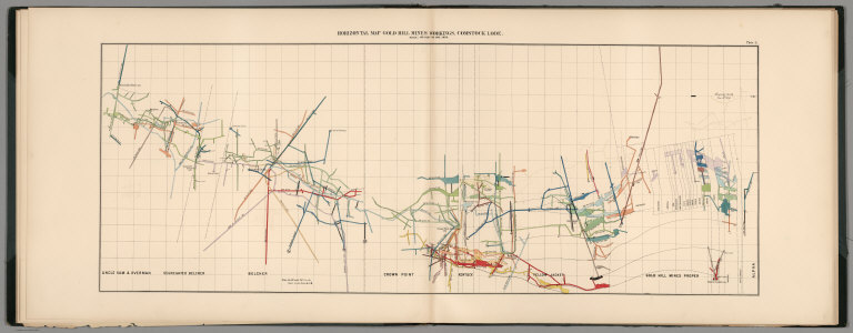
Full Title
Plate 3. Horizontal Map Gold Hill Mines Workings, Comstock Lode.
List No
0407.005
Note
Oriented north to right. Hand colored. Drifts color-coded to depth.
Author
King, Clarence
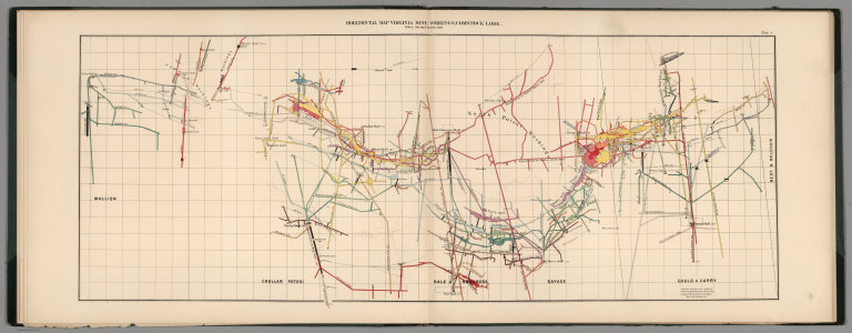
Full Title
Plate 4. Horizontal Map Virginia Mines Workings, Comstock Lode.
List No
0407.006
Note
Oriented north to right. Hand colored. Drifts color-coded to depth.
Author
King, Clarence
Full Title
Plate 5. Horizontal Map North Virginia Mines Workings, Comstock Lode.
List No
0407.007
Note
Oriented north to right. Hand colored. Drifts color-coded to depth.
Author
King, Clarence
Full Title
Plate 6. Longitudinal Elevation Gold Hill Mines, Comstock Lode.
List No
0407.008
Author
King, Clarence
Full Title
Plate 7. Longitudinal Elevation Virginia Mines, Comstock Lode.
List No
0407.009
Note
Printed color and hand colored. Drifts or levels colored to correspond with depth.
Author
King, Clarence
Full Title
Plate 8. Cross Sections Gold Hill Mines, Comstock Lode.
List No
0407.010
Author
King, Clarence
Full Title
Plate 9. Cross Sections Virginia Mines, Comstock Lode.
List No
0407.011
Author
King, Clarence
Full Title
Plate 10. Cross Sections Virginia Mines, Comstock Lode.
List No
0407.012
Author
King, Clarence
Full Title
Plate 11. Cross Sections Virginia Mines, Comstock Lode.
List No
0407.013
Author
King, Clarence
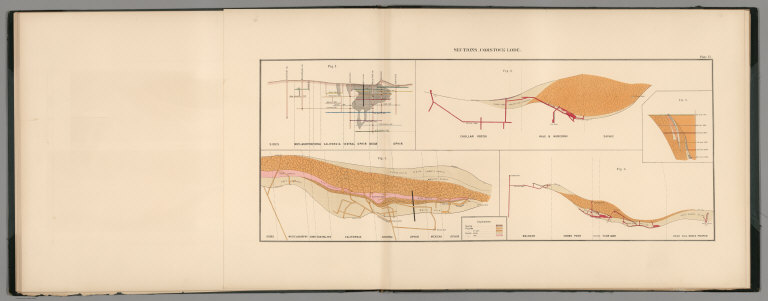
Full Title
Plate 12. Sections, Comstock Lode.
List No
0407.014
Author
King, Clarence
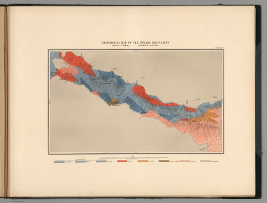
Full Title
Plate 13. Geological Map of the Toyabe (Toiyabe) Mountains. Geology: S.F. Emmons. Topography: A.D. Wilson.
List No
0407.015
Note
Full color. Relief shown as contours. North to the left.
Author
King, Clarence
Full Title
Plate 14. Geological Map of the White Pine Mining District. Geology: A. Hague. Topography: F.A. Clark.
List No
0407.016
Note
Relief depicted with contours. Full color. North to the right.
Author
Spurr, Josiah Edward
Full Title
(Covers to) Department Of The Interior, United States Geological Survey, Charles D. Walcott, Director. Atlas To Accompany Monograph XXXI On The Geology Of The Aspen District Colorado By Josiah Edward Spurr, Samuel Franklin Emmons, Geologist In Charge. Washington 1898. Julius Bien & Co. Lith. N.Y.
List No
0942A
Note
Bound in original dark brown cloth covered boards with "United States Geological Survey, Charles D. Walcott, Director. Atlas To Accompany Monograph XXXI On The Geology Of The Aspen District Colorado. Josiah Edward Spurr" stamped in gilt.
Author
Spurr, Josiah Edward
Full Title
(Title Page to) Department Of The Interior, United States Geological Survey, Charles D. Walcott, Director. Atlas To Accompany Monograph XXXI On The Geology Of The Aspen District Colorado By Josiah Edward Spurr, Samuel Franklin Emmons, Geologist In Charge. Washington 1898. Julius Bien & Co. Lith. N.Y.
List No
0942B
Author
Spurr, Josiah Edward
Full Title
(Table of Contents to) Department Of The Interior, United States Geological Survey, Charles D. Walcott, Director. Atlas To Accompany Monograph XXXI On The Geology Of The Aspen District Colorado By Josiah Edward Spurr, Samuel Franklin Emmons, Geologist In Charge. Washington 1898. Julius Bien & Co. Lith. N.Y.
List No
0942C
Author
Spurr, Josiah Edward
Full Title
(Legend to) Department Of The Interior, United States Geological Survey, Charles D. Walcott, Director. Atlas To Accompany Monograph XXXI On The Geology Of The Aspen District Colorado By Josiah Edward Spurr, Samuel Franklin Emmons, Geologist In Charge. Washington 1898. Julius Bien & Co. Lith. N.Y.
List No
0942D
Note
Provides a description of the atlas and geology of the Aspen Mining District, Colorado.
Author
Spurr, Josiah Edward
Full Title
Aspen District Sheet. Geology Sheet VI . U. S. Geological Survey, Charles D. Walcott, Director. Monograph XXXI. A.H. Thompson, Geographer. Morris Bien, Topographer in charge. Triangulation by Morris Bien. Topography by F.F. Grove. Surveyed in 1891. S.F. Emmons, Geologist in charge. Geology by J.E. Spurr. Assistant, G.W. Tower. Julius Bien & Co. Lith. N.Y. (1898)
List No
0942.003
Note
Topography shown by 100-foot contours. Shows streams, mines, roads, trails, and settlements. Geology shown in 16 colored classes, and faults. Shows alignment of cross-sections presented on the subsequent sheet.
Author
Spurr, Josiah Edward
Full Title
Sheet VII Sections. U. S. Geological Survey, Charles D. Walcott, Director. Monograph XXXI. Julius Bien & Co. Lith. N.Y. (1898)
List No
0942.004
Note
Geology shown in 16 colored classes, and faults.
Author
Spurr, Josiah Edward
Full Title
Aspen Special Sheet. Geology Sheet IX. U. S. Geological Survey, Charles D. Walcott, Director. Monograph XXXI. A.H. Thompson, Geographer. Morris Bien, Topographer in charge. Triangulation by Morris Bien. Topography by F.F. Grove. Surveyed in 1891. S.F. Emmons, Geologist in charge. Geology by J.E. Spurr. Assistant, G.W. Tower. Julius Bien & Co. Lith. N.Y. (1898)
List No
0942.006
Note
Geology shown in color in 11 classes, and faults. Cross section alignments provided in next sheet shown here.
Author
Spurr, Josiah Edward
Full Title
Aspen Special Sheet. Sheet X Sections. U. S. Geological Survey, Charles D. Walcott, Director. Monograph XXXI. Julius Bien & Co. Lith. N.Y. (1898)
List No
0942.007
Note
Geologic cross-sections shown in color in 11 classes, and faults.
Author
Spurr, Josiah Edward
Full Title
Tourtelotte Park Special. Geology Sheet XII. U. S. Geological Survey, Charles D. Walcott, Director. Monograph XXXI. A.H. Thompson, Geographer. Morris Bien, Topographer in charge. Triangulation by Morris Bien. Topography by F.F. Grove. Surveyed in 1891. S.F. Emmons, Geologist in charge. Geology by J.E. Spurr. Assistant, G.W. Tower. Julius Bien & Co. Lith. N.Y. (1898)
List No
0942.009
Note
Geology shown in color with 10 classes of rock, and faults. Shows alignment of cross-sections on following sheets.
Author
Spurr, Josiah Edward
Full Title
Tourtelotte Park Special Sheet. Sheet XIII Sections. U. S. Geological Survey, Charles D. Walcott, Director. Monograph XXXI. Julius Bien & Co. Lith. N.Y. (1898)
List No
0942.010
Note
Geologic cross-sections shown in color in 9 classes, and faults.
Author
Spurr, Josiah Edward
Full Title
Tourtelotte Park Special Sheet. Sheet XIV Sections. U. S. Geological Survey, Charles D. Walcott, Director. Monograph XXXI. Julius Bien & Co. Lith. N.Y. (1898)
List No
0942.011
Note
Geologic cross-sections shown in color in 9 classes, and faults.
Author
Spurr, Josiah Edward
Full Title
Tourtelotte Park Special Sheet. Sheet XV Sections. U. S. Geological Survey, Charles D. Walcott, Director. Monograph XXXI. Julius Bien & Co. Lith. N.Y. (1898)
List No
0942.012
Note
Geologic cross-sections shown in color in 9 classes, and faults.
Author
Spurr, Josiah Edward
Full Title
Hunter Park Special Sheet. Geology Sheet XVII . U. S. Geological Survey, Charles D. Walcott, Director. Monograph XXXI. A.H. Thompson, Geographer. F.M Douglas, Topographer in charge. Triangulation by E.M. Douglas. Topography by (R.C. McKinney). S.F. Emmons, Geologist in Charge. Geology by J.E. Spurr. Assistant, G.W. Tower. Surveyed in 1893. Julius Bien & Co. Lith. N.Y. (1898)
List No
0942.014
Note
Geology shown in color in 8 classes of rock, and faults. Alignment of cross-sections on next sheet shown.
Author
Spurr, Josiah Edward
Full Title
Hunter Park Special Sheet. Sheet XVIII Sections. U. S. Geological Survey, Charles D. Walcott, Director. Monograph XXXI. Julius Bien & Co. Lith. N.Y. (1898)
List No
0942.015
Note
Geologic cross-sections shown in color in 8 classes, and faults.
Author
Spurr, Josiah Edward
Full Title
Lenado Special Sheet. Geology Sheet XX . U. S. Geological Survey, Charles D. Walcott, Director. Monograph XXXI. A.H. Thompson, Geographer. F.M Douglas, Topographer in charge. Triangulation by E.M. Douglas. Topography by W.B. Gorse and R.H. Chapman. Surveyed in 1893. S.F. Emmons, Geologist in Charge. Geology by J.E. Spurr. Assistant, G.W. Tower. Julius Bien & Co. Lith. N.Y. (1898)
List No
0942.017
Note
Geology shown in color in 8 classes of rock, and faults. Map and cross sections on one sheet.
Author
Spurr, Josiah Edward
Full Title
Tourtelotte Park Mining District Sheet. Geology Sheet XXI. U. S. Geological Survey, Charles D. Walcott, Director. Monograph XXXI. A.H. Thompson, Geographer. Morris Bien, Topographer in charge. Triangulation by Morris Bien. Topography by F.F. Grove. Surveyed in 1891. S.F. Emmons, Geologist in charge. Geology by J.E. Spurr. Assistant, G.W. Tower. Julius Bien & Co. Lith. N.Y. (1898)
List No
0942.018
Note
Geology shown in color with 10 classes of rock, and faults. Shows alignment of cross-sections on following sheets.
Author
Spurr, Josiah Edward
Full Title
Tourtelotte Park Mining District Sheet. Sheet XXII Sections. U. S. Geological Survey, Charles D. Walcott, Director. Monograph XXXI. Julius Bien & Co. Lith. N.Y. (1898)
List No
0942.019
Note
Geologic cross-sections shown in color in 9 classes, and faults.
Author
Spurr, Josiah Edward
Full Title
Tourtelotte Park Mining District Sheet. Sheet XXIII Sections. U. S. Geological Survey, Charles D. Walcott, Director. Monograph XXXI. Julius Bien & Co. Lith. N.Y. (1898)
List No
0942.020
Note
Geologic cross-sections shown in color in 9 classes, and faults.
Author
Spurr, Josiah Edward
Full Title
Tourtelotte Park Mining District Sheet. Sheet XXIV Sections. U. S. Geological Survey, Charles D. Walcott, Director. Monograph XXXI. Julius Bien & Co. Lith. N.Y. (1898)
List No
0942.021
Note
Geologic cross-sections shown in color in 9 classes, and faults.
Author
Spurr, Josiah Edward
Full Title
Aspen Mountain Sheet. Geology Sheet XXV. U. S. Geological Survey, Charles D. Walcott, Director. Monograph XXXI. A.H. Thompson, Geographer. Morris Bien, Topographer in charge. Triangulation by Morris Bien. Topography by F.F. Grove. Surveyed in 1891. S.F. Emmons, Geologist in charge. Geology by J.E. Spurr. Assistant, G.W. Tower. Julius Bien & Co. Lith. N.Y. (1898)
List No
0942.022
Note
Geology shown in color with 10 classes of rock, and faults. Shows alignment of cross-sections on following sheet.
Author
Spurr, Josiah Edward
Full Title
Aspen Mountain Sheet. Sheet XXVI Sections. U. S. Geological Survey, Charles D. Walcott, Director. Monograph XXXI. Julius Bien & Co. Lith. N.Y. (1898)
List No
0942.023
Note
Geologic cross-sections shown in color in 10 classes, and faults.
Author
Spurr, Josiah Edward
Full Title
Smuggler Mountain. Geology Sheet XXVII. U. S. Geological Survey, Charles D. Walcott, Director. Monograph XXXI. A.H. Thompson, Geographer. Morris Bien, Topographer in charge. Triangulation by Morris Bien. Topography by F.F. Grove. Surveyed in 1891. S.F. Emmons, Geologist in charge. Geology by J.E. Spurr. Assistant, G.W. Tower. Julius Bien & Co. Lith. N.Y. (1898)
List No
0942.024
Note
Geology shown in color with 9 classes of rock, and faults. Shows alignment of cross-sections on following sheets.
Author
Spurr, Josiah Edward
Full Title
Smuggler Mountain Sheet. Sheet XXVIII Sections. U. S. Geological Survey, Charles D. Walcott, Director. Monograph XXXI. Julius Bien & Co. Lith. N.Y. (1898)
List No
0942.025
Note
Geologic cross-sections shown in color in 9 classes, and faults.
Author
Spurr, Josiah Edward
Full Title
Smuggler Mountain Sheet. Sheet XXIX Sections. U. S. Geological Survey, Charles D. Walcott, Director. Monograph XXXI. Julius Bien & Co. Lith. N.Y. (1898)
List No
0942.026
Note
Geologic cross-sections shown in color in 9 classes, and faults.
Author
Spurr, Josiah Edward
Full Title
Lenado Mining District Sheet. Sheet XXX Sections. U. S. Geological Survey, Charles D. Walcott, Director. Monograph XXXI. Julius Bien & Co. Lith. N.Y. (1898)
List No
0942.027
Note
Geologic map and cross-sections shown in color in 7 classes, and faults.
Author
Becker, George F.
Full Title
(Covers to) Department Of The Interior, United States Geological Survey, Clarence King Director. Atlas To Accompany The Monograph On The Geology Of The Comstock Lode And The Washoe District By George F. Becker. Washington 1882. Julius Bien & Co. Lith. New York.
List No
1566A
Author
Becker, George F.
Full Title
(Title Page to) Department Of The Interior, United States Geological Survey, Clarence King Director. Atlas To Accompany The Monograph On The Geology Of The Comstock Lode And The Washoe District By George F. Becker. Washington 1882. Julius Bien & Co. Lith. New York.
List No
1566B
Note
An important atlas of the mining activity in the Comstock Lode. With printed color. Bound in brown cloth covered boards with "United States Geological Survey, Clarence King, Director. Atlas To Accompany The Geology Of The Comstock Lode And The Washoe District. Becker" stamped in gilt.
Author
Becker, George F.
Full Title
(Index to) Department Of The Interior, United States Geological Survey, Clarence King Director. Atlas To Accompany The Monograph On The Geology Of The Comstock Lode And The Washoe District By George F. Becker. Washington 1882. Julius Bien & Co. Lith. New York.
List No
1566C
Author
Becker, George F.
Full Title
Map of the Washoe District Showing Mining Claims. United States Geological Survey. Geology of the Comstock Lode, &c. Atlas Sheet III. Claims Mapped by Hoffman and Craven, 1881. Topography by U.S. Geographical Surveys West of the 100th Meridian. G.F. Becker, Geologist in Charge. Julius Bien & Co. Lith. N.Y.
List No
1566.001
Note
Map in color showing the mining claims in Washoe county. The dark blue lines indicate patented claims, and the dotted lines show claims for which patents have been applied. U.S. Survey and private survey lines are also included. Base map is topographic with contour intervals at 50 feet.
Author
Becker, George F.
Full Title
Geological Map of the Washoe District. United States Geological Survey. Geology of the Comstock Lode, &c. Atlas Sheet IV. Topography by U.S. Geographical Surveys West of the 100th Meridian. Geology by G.F. Becker, Geologist in Charge. Julius Bien & Co. Lith. N.Y.
List No
1566.002
Note
Map in full color showing geology of the same area as shown on the mining district map. Legend sits below the map.
Author
Becker, George F.
Full Title
Vertical Cross Sections of the Lode. United States Geological Survey. Geology of the Comstock Lode, &c. Atlas Sheet V. Mapping by R.H. Stretch. Geology by G.F. Becker, Geologist in Charge. Julius Bien & Co. Lith. N.Y.
List No
1566.003
Note
Four cross sections included: 1) Section through the Utah shaft; 2) Section through the Union shaft; 3) Section through the Sierra Nevada shaft; 4) Section through the C. and C. shaft. In full color with a legend explaining the diagrams.
Author
Becker, George F.
Full Title
Vertical Cross Sections of the Lode. United States Geological Survey. Geology of the Comstock Lode, &c. Atlas Sheet VI. Mapping by R.H. Stretch. Geology by G.F. Becker, Geologist in Charge. Julius Bien & Co. Lith. N.Y.
List No
1566.004
Note
Page includes the vertical section on line of Sutro Tunnel and through Baltimore and Forman Shafts. In full color with accompanying legend.
Author
Becker, George F.
Full Title
Vertical Cross Sections of the Lode. United States Geological Survey. Geology of the Comstock Lode, &c. Atlas Sheet VII. Mapping by R.H. Stretch. Geology by G.F. Becker, Geologist in Charge. Julius Bien & Co. Lith. N.Y.
List No
1566.005
Note
In full color and showing four maps: 1) Section through Hale and Northcross shaft; 2) Section through Belcher Mine; 3) Section through Yellow Jacket shafts; 4) Faulted structure on the Sutro tunnel section (at a scale of 1:9,600). With accompanying legend.
Author
Becker, George F.
Full Title
Horizontal Section of the Comstock Lode at the Sutro Tunnel Level (1900 ft.) and below. Horizontal Section of the Lode. North End. United States Geological Survey. Geology of the Comstock Lode, &c. Atlas Sheet VIII. Mapping by R.H. Stretch. Geology by G.F. Becker, Geologist in Charge. Julius Bien & Co. Lith. N.Y.
List No
1566.006
Note
In full color with the names of the shaft owners included on the map. An inset map shows the Comstock Lode at the 2,500 foot level.
Author
Becker, George F.
Full Title
Horizontal Section of the Comstock Lode at the Sutro Tunnel Level (1900 ft.) and below. Horizontal Section of the Lode. South End. United States Geological Survey. Geology of the Comstock Lode, &c. Atlas Sheet IX. Mapping by R.H. Stretch. Geology by G.F. Becker, Geologist in Charge. Julius Bien & Co. Lith. N.Y.
List No
1566.007
Note
In full color with an uncolored inset map showing the Comstock Lode at 2,400 feet and below. The owners of the shafts are shown.
Author
Becker, George F.
Full Title
Longitudinal Vertical Projection of the Comstock Lode. Number I. United States Geological Survey. Geology of the Comstock Lode, &c. Atlas Sheet X. Mapping by R.H. Stretch. G.F. Becker, Geologist in Charge. Julius Bien & Co. Lith. N.Y.
List No
1566.008
Note
Map without color. Map depicts mine shafts with areas of ore body extraction shown in gray.
|