|
Author
Shane, Ralph M.
Full Title
Historical Map Warm Springs Indian Reservation. Warm Springs, Oregon. Revised edition...1974
List No
15874.000
Author
Cram, George Franklin, 1841-1928
Full Title
(Composite Map to) Western part of Washington. -- Eastern part of Washington. 1899, by Geo. F. Cram.
List No
14372.223
Note
Composite map of Washington (western and eastern halves). Shows political boundaries, counties, towns, Indian reservations, mines, railroads, topography, bodies of water, drainage, coastlines and islands. Relief shown with hachures. Includes keys with explanations, latitudinal and longitudinal lines, as well as bar scales given in miles. With alphanumeric grid corresponding to "Index of Washington" on pages 403 and 406-407. Colored lithograph. Together, map is 55 x 80 cm, on two double sheets 67 x 90 cm. "Index of maps" and "Index of cities" in margins, providing navigation for atlas as a whole.
Author
[Ravenstein, August, Berlin Geographisch-Artistische Anstalt Ernst Schotte]
Full Title
Nord-u. Mittel-Amerika. Zeichnung u. Modell von August Ravenstein in Frankfurt a. M. Stich, Prägung, Druck u. Verlag von B. Dondorf in Frankfurt a. M.
List No
14473.007
Note
Relief map of North and Central America. Shows geographical regions, countries, cities, railways, topography, vegetation, bodies of water, drainage, coastlines, shoals and islands. Topography shown with raised relief. Includes a legend, bar scale given in miles, latitudinal and longitudinal lines, as well as statistical and descriptive notes. Additional legend for map appears on title page. With an indexed vignette of scenery, figures, fauna and flora. Colored lithograph. Map is 27 x 22 cm, within frame 28 x 24 cm. Within a series of eight maps comprising the school atlas, Plastischer Schul-Atlas.
Author
Pistacchi, Andre
Full Title
America Septentrionale. America map by Andrea Pistacchi.
List No
14405.003
Note
Pictorial map of North America, depicting adventures of the character Corto Maltese. Also shows indigenous territories, cities, routes, topography, deserts, bodies of water, drainage, coastlines and islands. Relief shown pictorially. Features illustrations of people, animals and plants. Includes numerous inset maps of various types, as well as images of stamps and other ephemera surrounding the continent. With vignette portraits of historical figures, such as Emiliano Zapata and Billie Holiday. Descriptive text throughout, including notes on colonial explorations. Colored lithograph. Map is 67 x 63 cm, on sheet 74 x 69 cm, folded to 23 x 19 cm. "Allegato al n. 10 di Corto Maltese 1986."
Author
[Shope, Irvin, Fletcher, Bob]
Full Title
[Hittin' the high spots in Montana].
List No
14466.002
Note
Pictorial map of Montana. Appears as a montage of photographic imagery featuring representative sites, animals and vegetation for the state. Margins filled with silhouette images of horse-drawn wagons and indigenous people. With decorative border. Map printed in black and white. Map is 43 x 56 cm, on sheet 44 x 57 cm.
Author
Faden, William, 1749-1836
Full Title
The United States of North America, with the British Territories, and those of Spain, according to the Treaty, of 1784. Engrav'd by Wm. Faden. 1793. Published as the Act directs, Feby. 11, 1793, by Willm. Faden, Geographer to the King, Charing Cross.
List No
14383.057
Note
Map of the United States, as of 1793. Shows political boundaries (including colonial possessions), cities, topography, bodies of water, drainage, coastlines, islands and sand banks. Marks territories inhabited by indigenous peoples, such as the "Western Sioux". Relief shown pictorially. Includes latitudinal and longitudinal lines, as well as a legend and two bar scales. Descriptive text throughout, including notes on exploration. Decorative cartouche. Hand-colored engraving. Map is 53 x 61 cm, on double sheet 55 x 75 cm. With stamp: Liverpool Library.
Author
Weiland, C. F. (Carl Ferdinand), 1782-1847
Full Title
Die Vereinigten Staaten von Nord America entworfen von C. F. Weiland. Weimar, im Verlag des Geograph. Instituts, 1828.
List No
14365.059
Note
Map of the United States, as of 1828. Shows political boundaries, cities, population, topography, bodies of water, drainage, coastlines, islands and territories of indigenous peoples. Relief shown with hachures. Includes latitudinal and longitudinal lines, as well as a legend and two bar scales. With hand-drawn annotation in blue colored pencil. Hand-colored engraving. Map is 30 x 43 cm, on sheet 45 x 57 cm. (Plate number taken from table of contents.)
Author
Burr, David H., 1803-1875
Full Title
Michigan. Drawn and published by David H. Burr. New-York.
List No
14341.003
Note
Map of Michigan and vicinity, including the Great Lakes. Shows political boundaries, cities, roads, water routes, topography, vegetation, drainage, shorelines and islands. Relief shown with hachures. Features the "Indian boundary line according to the Saginaw Treaty." Includes a bar scale, given in American miles, as well as latitudinal and longitudinal lines. Hand-colored engraving. Map is 31 x 25 cm, on sheet 43 x 35 cm. "Entered according to act of Congress in the year 1831 by David H. Burr, in the Clerk's office of the District Court for the Southern District of New-York."
Author
Burr, David H., 1803-1875
Full Title
Ohio. Drawn and published by David H. Burr. New-York.
List No
14341.004
Note
Map of Ohio and vicinity. Shows political boundaries, cities, roads, canals, water routes, drainage, shorelines and islands. Features the Seneca Indian Reservation, in Seneca County. Includes a bar scale, given in American miles, as well as latitudinal and longitudinal lines. Hand-colored engraving. Map is 25 x 30 cm, on sheet 35 x 43 cm. "Entered according to act of Congress in the year 1831 by David H. Burr, in the Clerk's office of the District Court for the Southern District of New-York."
Author
Geological Survey (U.S.)
Full Title
Central Pacific states.
List No
14359.026
Note
Map representing the Central Pacific States within the United States, as of 1970. Shows political boundaries, cities, railways, roads, ferry lines, Indian reservations, national forests and parks, mountains, mesas, valleys, deserts, bodies of water, drainage, coastlines and islands. Relief shown with labeling of mountain names and peak heights. Features population density for each city. Includes latitudinal and longitudinal lines, bar scale and scale statement. Presented with Albers Equal Area Projection. Colored lithograph. Map is 42 x 68 cm, on double sheet 49 x 71 cm. Index map and legend appear on page 5. Appears in General reference maps section.
Author
Geological Survey (U.S.)
Full Title
Urban areas : Seattle, Wash. -- San Francisco, Calif. -- Los Angeles, Calif. -- Denver, Colo. -- Minneapolis - St. Paul, Minn. -- St. Louis, Mo. -- Fort Worth - Dallas, Tex. -- Kansas City, Mo. -- San Diego, Calif. -- Houston, Tex.
List No
14359.034
Note
Eleven maps representing urban areas in the United States, as of 1970. Maps show political boundaries, cities, railways, roads, ferry lines, Indian reservations, national forests, mountains, bodies of water, swamps, drainage, coastlines and islands. Relief shown with labeling of mountain names and peak heights. Features population density for each city. Maps include latitudinal and longitudinal lines and scale statements. Colored lithograph. Together, maps are 42 x 65 cm, on double sheet 49 x 71 cm. Index map and legend appear on page 5. Maps appear in General reference maps section.
Author
[Geological Survey (U.S.), Sturtevant, William C.]
Full Title
Early Indian tribes, culture areas, and linguistic stocks / William C. Sturtevant, Smithsonian Institution, 1967.
List No
14359.094
Note
Historical map representing the United States, featuring the territories and cultural areas and languages of early indigenous peoples, as of around 1899. Shows both major and minor tribes, political boundaries (present-day), bodies of water, drainage, coastlines and islands. Includes a legend, latitudinal and longitudinal lines, as well as a bar scale and scale statement. Presented with Albers Equal Area Projection. With two inset maps: Principal islands of Hawaii -- Alaska. Colored lithograph. Map is 43 x 66 cm, on double sheet 49 x 71 cm. Also, with bibliography for further reading. Accompanying descriptive text on page 132. Appears in Special subject maps section, subsection History.
Author
[Geological Survey (U.S.), Sturtevant, William C.]
Full Title
Early Indian tribes, culture areas, and linguistic stocks : [Alaska] / William C. Sturtevant, Smithsonian Institution, 1967.
List No
14359.095
Note
Historical map representing Alaska, featuring the territories and cultural areas and languages of early indigenous peoples, as of around 1899. Shows both major and minor tribes, political boundaries (present-day), bodies of water, drainage, coastlines and islands. Includes a legend, latitudinal and longitudinal lines, as well as a bar scale and scale statement. Presented with Albers Equal Area Projection. Colored lithograph. Map is divided into two parts, together 33 x 32 cm, on sheet 49 x 35 cm. Accompanied by descriptive text, with references. Appears in Special subject maps section, subsection History.
Author
[Geological Survey (U.S.), Goetzmann, William H.]
Full Title
Exploration and settlement : 1850-1890 / compiled from information provided by William H. Goetzmann, Univertsity of Texas, 1966.
List No
14359.102
Note
Historical map representing the United States, featuring voyages of exploration and settlement from 1850 to 1890. Maps show the routes of explorers, settlements (including both colonial and indigenous), forts, railways, roads, trails, canals, mines, the extent of colonized area, topography, bodies of water, coastlines and islands. Relief shown with shading. Includes legends, as well as a bar scale and scale statement. With inset map: Alaska. Colored lithograph. Map is 20 x 30 cm, on sheet 49 x 35 cm. Accompanied by descriptive text, with references. Appears in Special subject maps section, subsection History.
Author
[Geological Survey (U.S.), U.S. Census Bureau]
Full Title
American Indian population : 1960 / adapted from U. S. Bureau of the Census, American Indians in the United States: 1960, GE-50, no. 14, Washington, U. S. Govt. Print Off., 1967, map 1:5,000,000.
List No
14359.193
Note
Statistical map representing the United States, featuring the geographic density of the indigenous population, as of 1960. Map also shows political boundaries, bodies of water, drainage, coastlines and islands. Includes a legend, as well as a bar scale and scale statement. Presented with Albers Equal Area Projection. With two inset maps: Principal islands of Hawaii -- Alaska. Colored lithograph. Map is 43 x 66 cm, on double sheet 49 x 71 cm. Appears in Special subject maps section, subsection Socio-Cultural.
Author
[National U. S. 66 Highway Association, Andrews, Willard]
Full Title
Follow U. S. 66 across Arizona through the southwest's scenic wonderland. Willard Andrews.
List No
14283.003
Note
Road map of Highway 66, from Yucca, Arizona to the Petrified Forest of Arizona. Includes a panoramic illustration featuring scenery along the way. With photographs in top and bottom margins, highlighting tourist sites, such as Meteor Crater. Unfolded to 23 x 41 cm.
Author
[National U. S. 66 Highway Association, Andrews, Willard]
Full Title
Follow U. S. 66 across New Mexico ... the land of enchantment. Willard Andrews.
List No
14283.004
Note
Road map of Highway 66, from Gallup to San Jon, New Mexico. Includes a panoramic illustration featuring scenery along the way. With photographs in top and bottom margins, highlighting tourist sites, such as Ice Caves. Also shows images of a Navajo silversmith and a weaver. Unfolded to 23 x 41 cm.
Author
[National U. S. 66 Highway Association, Andrews, Willard]
Full Title
Follow U. S. 66 across the Texas Panhandle and beautiful Oklahoma. Willard Andrews.
List No
14283.005
Note
Road map of Highway 66, from Glenrio, Texas to Bristow, Oklahoma. Includes a panoramic illustration featuring scenery along the way. With photographs in top and bottom margins, highlighting tourist sites, such as Light House, Palo Duro Canyon. Unfolded to 23 x 41 cm.
Author
[National U. S. 66 Highway Association, Andrews, Willard]
Full Title
Follow U. S. 66 across Missouri, the "Show Me State" ... Play in the Ozarks ... See Illinois. Willard Andrews.
List No
14283.006
Note
Road map of Highway 66, from Sapulpa, Oklahoma to Chicago, Illinois. Includes a panoramic illustration featuring scenery along the way. With photographs in top and bottom margins, highlighting tourist sites, such as Underland Wonderland. Unfolded to 23 x 41 cm.
Author
Amerine & Wilson
Full Title
Amerine & Wilson's indexed township & county map of California. Compiled and published by Amerine and Wilson, Map Publishers and Mounters, 815 Montgomery St., San Francisco Cal, 1892. Copyrighted by Amerine & Wilson 1892. Photo. lith. Britton & Rey, S.F.
List No
14267.002
Note
Colored photo-lithographed map of California with townships and counties, as of 1892. Shows political boundaries, topography, lakes, drainage, marshlands, coastline, islands, ports, cities and towns, railroads (completed, under construction and proposed), wagon roads, trails and "Indian Reservations", such as "Mission" in the San Jacinto Mountains and "Round Valley" near Mendocino. Relief shown with hachures. Eastern part of San Bernadino and San Diego Counties depicted on right of sheet. Includes a legend and a bar scale. Additional explanation appears on verso of front cover. Indexed to indicate towns, counties, post offices, and population according to the latest census. Lake Tahoe also labeled Bigler. Map is 86 x 65 cm, on sheet 92 x 70 cm.
Author
[Nolin, Jean Baptiste, 1648-1708, Du Tralage, Jean Nicolas, -169, Coronelli, Vincenzo (1650-1718)]
Full Title
L'Amerique Septentrionale, ou la Partie Septentrionale des Indes Occidentales. Dressée sur les Memoires les plus Nouveaux. Corrigée et augmentée par le Sr. Tillemon; et dediée a son Excellence Monseigneur Pierre Venier, Ambassadeur ordinaire de la Serenissime Republique de Venise, pres de la Majesté tres Chrestienne Lovis le Grand. Par le P. Coronelli, Cosmographe de la Serme. Republique de Venise. A Paris, Chez J. B. Nolin, sur le Quay de l’Horloge du Palais, Vers le Pont Neuf, a l'enseigne de la Place des Victoires. Avec Privilege du Roy. 1689.
List No
14353.046
Note
Map of North America. Title translates to: North America, or the northern part of the West Indies, built on the newer memories. Shows political boundaries, cities, topography, volcanos, lakes, drainage, coastlines, shoals, islands and ocean routes. Features the territories of indigenous peoples therein. California shown as an island. Relief shown pictorially. Includes latitudinal and longitudinal lines, as well as a legend, six bar scales and explanatory notes. Decorative cartouche with an indigenous figure and a colonizer. Black and white engraving with hand-colored borders. Map is 43 x 59 cm, on double sheet 50 x 67 cm. (Plate number handwritten in ink on verso.)
Author
[Nolin, Jean Baptiste, 1648-1708, Coronelli, Vincenzo (1650-1718), Du Tralage, Jean Nicolas, -169]
Full Title
Partie Orientale du Canada ou de la Nouvelle France ou sont les Provinces, ou Pays de Sagvenay, Canada, Acadie etc. les Peuples, ou Nations des Etechemins, Iroquois, Attiquameches etc. Avec la Nouvelle Angleterre, la Nouvelle Ecosse, la Nouvelle Yorck, et la Virginie, les Isles de Terre Neuve, de Cap Breton etc. le Grand Banc etc. Dressee sur les Memoires les plus Nouveaux. Par le P. Coronelli Cosmographe de la Serenisme. Rep. de Venise. Corrigée et augmentée par le Sr. Tillemon; et dediée a Monsieur l'Abbé Baudrand. Par son tres humble Serviteur J. B. Nolin. A Paris, Chez J. B. Nolin, sur le Quay de l’Horloge du Palais, proche le Pont Neuf, a l'enseigne de la Place des Victoires. Avec Privilege du Roy. 1689.
List No
14353.048
Note
Map of eastern Canada. Title translates to: Eastern part of Canada or New France, with the Provinces, of Saguenay, Canada, Acadia etc., and the peoples, or nations of Etechemins, Iroquois, Attiquameches etc, and with New England, Nova Scotia, New York, and Virginia, the Isles of Newfoundland, Cape Breton etc. Shows political boundaries, cities, forts, topography, lakes, drainage, coastlines, shoals, islands and sea monsters. Features the territories of indigenous peoples therein. Relief shown pictorially. Includes latitudinal and longitudinal lines, as well as a legend, four bar scales and explanatory notes. Decorative cartouche with indigenous figures, flora and fauna. Black and white engraving with hand-colored borders. Map is 43 x 58 cm, on double sheet 50 x 67 cm. (Plate number handwritten in ink on verso.)
Author
[Nolin, Jean Baptiste, 1648-1708, Coronelli, Vincenzo (1650-1718), Du Tralage, Jean Nicolas, -169]
Full Title
Partie Occidentale du Canada ou de la Nouvelle France ou sont les Nations des Ilinois, de Tracy, les Iroquois, et plusieurs autres Peuples; avec la Louisiane Nouvellement decouverte etc. Dressée sur les Memoires les plus Nouveaux. Par le P. Coronelli Cosmographe de la Serme. Repub. de Venise. Corrigée et augmentée par le Sr. Tillemon; et dediée a Monsieur l'Abbé Baudrand. A Paris, Chez J. B. Nolin, sur le Quay de l’Horloge du Palais Vers le Pont Neuf, a l'enseigne de la Place des Victoires. Avec Privilege du Roy. 1688.
List No
14353.049
Note
Map of western Canada. Title translates to: Western part of Canada or New France, with the Nations of the Illinois, Tracy, the Iroquois, and several other peoples; with newly discovered Louisiana etc. Shows political boundaries, cities, forts, topography, lakes, drainage, shorelines and islands. Features the territories of indigenous peoples therein. Relief shown pictorially. Includes latitudinal and longitudinal lines, as well as five bar scales and explanatory notes. Decorative cartouche with indigenous figures, flora and fauna. Black and white engraving with hand-colored borders. Map is 44 x 59 cm, on double sheet 50 x 67 cm. (Plate number handwritten in ink on verso.)
Author
[Nolin, Jean Baptiste, 1648-1708, Coronelli, Vincenzo (1650-1718), Du Tralage, Jean Nicolas, -169]
Full Title
Le Nouveau Mexique appelé aussi Nouvelle Grenade et Marata. Avec Partie de Californie. Selon les Memoires les plus Nouveaux. Par le Pere Coronelli Cosmographe de la Ssme. Republique de Venise. Corrigée et augmentée par le Sr. Tillemon. A Paris, Chez J. B. Nolin, sur le Quay de l’Horloge à l'enseigne de la Place des Victoires. Vers le Pont Neuf. Avec Privilege du Roy. 168.
List No
14353.050
Note
Map of the western United States. Title translates to: New Mexico, also called New Granada and Marata, with part of California, according to the newer memories. Shows political boundaries, cities, topography, lakes, drainage, coastlines and islands. Features the territories of indigenous peoples therein. California shown as an island. Relief shown pictorially. Includes latitudinal and longitudinal lines, as well as five bar scales and explanatory notes. Decorative cartouche with indigenous figures and colonizers. Black and white engraving with hand-colored borders. Map is 43 x 58 cm, on double sheet 50 x 67 cm. (Plate number handwritten in ink on verso.)
Author
[Nolin, Jean Baptiste, 1648-1708, Coronelli, Vincenzo (1650-1718), Du Tralage, Jean Nicolas, -169]
Full Title
L'Amerique Meridionale, ou la Partie Meridionale des Indes Occidentales. Dressée sur les Memoires les plus Nouveaux et dediée a Monseigneur Jacques Colombo Secretaire de la Serenissime Republique de Venise. Par le P. Coronelli, Geographe de la Serme. Rep. de Venise, corrigée et augmentée par le Sr. Tillemon. A Paris, Chez J. B. Nolin, sur le Quay de l’Horloge du Palais proche le Pont Neuf à l'enseigne de la Place des Victoires. Avec Privilege du Roy. 1689.
List No
14353.051
Note
Map of South America. Title translates to: South America, or the southern part of the West Indies, drawn upon the most recent memories. Shows political boundaries, cities, topography, lakes, drainage, coastlines, shoals, islands and ocean routes. Features the territories of indigenous peoples therein. Relief shown pictorially. Includes latitudinal and longitudinal lines, as well as a legend, six bar scales and explanatory notes. Decorative cartouches with figures. Black and white engraving with hand-colored borders. Map is 44 x 58 cm, on double sheet 50 x 67 cm. (Plate number handwritten in ink on verso.)
Author
Pittman, Philip, active 1760-1770
Full Title
Draught of the R. Ibbevelle, being a short communication from the sea to the first of the English settlements on the Mississippi. Thos. Kitchin sculp.
List No
14327.025
Note
Map of the Ibbeville River [Manchac Bayou] and the Massiac River, part of the Amit [Amite] River, as well as Lake Maurepas, Louisiana. Shows towns, lakes, channels, shorelines and depths, in fathoms. Features part of the Mississippi River, where it meets the Ibbeville River, at the top of the map. The Ibbeville links the Amit and Mississippi Rivers. Includes a scale statement - "Scale French league to 1 inch" - and a compass rose, with north oriented toward top right side of sheet. Descriptive text throughout, such as: Indian encampment, some canoes come up as far as this. Black and white engraving. Map is 53 x 23 cm, on fold-out sheet 54 x 36 cm. Accompanied by descriptive text, spanning pages 26-32.
Author
[Pawley, Neele, Samuel John, 1758-1824, Neele, George, Pinnock and Maunder]
Full Title
N. America. Neele sculp. Published Jany. 1st. 1819, by Pinnock & Maunder Strand.
List No
14326.040
Note
Map of North America and vicinity. Shows political boundaries, cities, railroads, topography, major lakes and drainage, coastlines and islands. Features the indigenous peoples living therein, such as the Pawnees and Osages. Relief shown with hachures. Includes latitudinal and longitudinal lines, as well as a compass rose and bar scale, given in British miles. Hand-colored engraving, including illustration of clouds behind title. Map is 27 x 21 cm, on sheet 34 x 26 cm.
Author
[Pawley, Neele, Samuel John, 1758-1824, Neele, George, Pinnock and Maunder]
Full Title
Canada. Neele sculp. Published Jany. 1st. 1819, by Pinnock & Maunder Strand.
List No
14326.041
Note
Map of Canada and vicinity. Shows political boundaries, cities, railroads, topography, major lakes and drainage, coastlines and islands. Features the indigenous peoples living therein, such as the Mohawk. Relief shown with hachures. Includes latitudinal and longitudinal lines, as well as a compass rose and bar scale, given in British statute miles. Hand-colored engraving, including illustration of clouds behind title. Map is 27 x 21 cm, on sheet 34 x 26 cm.
Author
[Pawley, Neele, Samuel John, 1758-1824, Neele, George, Pinnock and Maunder]
Full Title
United States. Neele sculp. Published Jany. 1st. 1819, by Pinnock & Maunder Strand.
List No
14326.042
Note
Map of the United States and vicinity. One of the few 19th century maps to show the proposed state of Franklinia in eastern Tennessee. Shows political boundaries, cities, railroads, topography, major lakes and drainage, coastlines and islands. Features the indigenous peoples living therein, such as the Chicasaw. Relief shown with hachures. Includes latitudinal and longitudinal lines, as well as a compass rose and bar scale, given in British miles. Hand-colored engraving, including illustration of clouds behind title. Map is 22 x 27 cm, on sheet 26 x 34 cm.
Author
American Airlines Inc.
Full Title
American Airlines. Copyright, General Drafting Co., Inc., 21 West Street, New York 6, N.Y. Lithographed in U.S.A.
List No
14277.002
Note
Colored lithograph map of North America representing air routes across the continent. Shows topography, major lakes and drainage, coastlines and airport locations for American Airlines. Relief shown pictorially. Globular map projection. Includes a decorative title cartouche. Map is 23 x 31 cm, folded to 23 x 11 cm. Verso features a map of air routes from North America across the Atlantic Ocean to Europe and Northern Africa. (Date estimated.)
Author
Shane, Ralph M.
Full Title
Early history, Blackfeet Indian Reservation, Montana. Compiled and drawn by Ralph M. Shane. 1966.
List No
13654.000
Author
Shane, Ralph M.
Full Title
Historical map of the Crow Indian Reservation : home of the Crows or Absarokee "children of the large beaked bird". Ralph M. Shane.
List No
13655.000
Author
Shane, Ralph M.
Full Title
Historical map of the Fort Belknap Indian Reservation : Gros Ventres & Assiniboines. Compiled and drawn by Ralph M. Shane. 1974
List No
13656.000
Author
Shane, Ralph M.
Full Title
History of the Indian tribes of Montana. Compiled and drawn by Ralph M. Shane. 1974
List No
13657.000
Author
Shane, Ralph M.
Full Title
Recreation and historical map, Fort Peck Reservation : home of the Assiniboine and Sioux. Drawn by Ralph M. Shane. 1978.
List No
13658.000
Author
Shane, Ralph M.
Full Title
Early history of the Northern Cheyennes, the Morning Star people. The Northern Cheyenne Indian Reservation Agency Headquarters: Lame Deer, Montana. Compiled and drawn by Ralph M. Shane. 1966.
List No
13659.000
Author
Shane, Ralph M.
Full Title
Historical map of the Rocky Boy's Reservation, Montana : home of the Chippewa-Cree, Montana. Compiled and drawn by Ralph M. Shane.
List No
13660.000
Author
Shane, Ralph M.
Full Title
Centennial historical map, Wind River Indian Reservation, 1868-1968 : home of the Shoshones and Arapahoes. Compiled and drawn by Ralph M. Shane. 1968.
List No
13661.000
Author
Shane, Ralph M.
Full Title
Historical map, confederated Salish and Kootenai tribes of the Flathead Reservation, Montana. Compiled and drawn by Ralph M. Shane. 1974.
List No
13662.000
Author
[Chatelain Henri, 1684-1743, Gueudeville, Nicolas]
Full Title
Carte Contenant le Royaume du Mexique et la Floride dressez sur les meilleures observations & sur les memoires les plus nouveaux. Tom. VI. No. 27. Pag. 101. (to accompany) Atlas Historique ... Tome VI. A Amsterdam, chez L'Honore & Chatelain Libraires. M DCC XIX (1719).
List No
13272.698
Note
Engraved map of North America and the West Indies, from Newfoundland and the Great Lakes to northern South America, based on de L'Isle's map of the southern part of North America. Covers New Mexico, Louisiana, from Florida through present-day Texas and the Gulf Coast region. Shows political boundaries, Indian settlements, cities, towns, ports, rivers, and notes the discoveries along the Gulf Coast and Mississippi River. Includes text. Relief shown pictorially.
Author
[Chatelain Henri, 1684-1743, Gueudeville, Nicolas]
Full Title
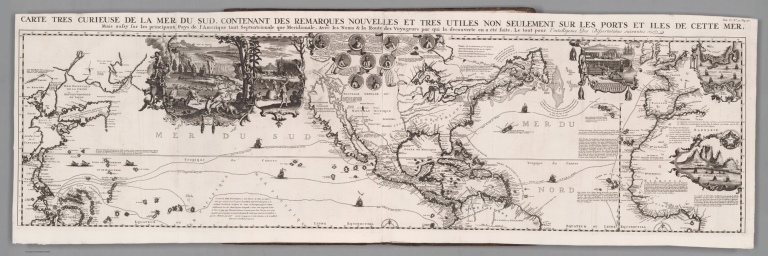
(Composite Map) Carte tres curieuse de la Mer du Sud, contenant des remarques nouvelles et tres utiles non seulement sur les ports et iles de cette mer, mais aussy sur les principaux pays de l'Amerique tant Septentroinale que Meridionale, Avec les noms & la route des voyageurs par qui la decouverte en a ete faite. Tom. VI. No. 30. Pag. 117. (to accompany) Atlas Historique ... Tome VI. A Amsterdam, chez L'Honore & Chatelain Libraires. M DCC XIX (1719).
List No
13272.713
Note
Composite map of the Pacific Ocean, centered on America.North and South sheets.
Author
[Chatelain Henri, 1684-1743, Gueudeville, Nicolas]
Full Title
Description de la peche, habillemens, habitations, manieres de vivre, superstitions et autres usages des Indiens de la Virginie; le tout fidellement extrait des mémoires et des desseins qui en out ete tirez sur les lieux. Tom. VI. No. 25. Pag. 100. (to accompany) Atlas Historique ... Tome VI. A Amsterdam, chez L'Honore & Chatelain Libraires. M DCC XIX (1719).
List No
13272.696
Note
Engraved views and description of native American way of life in Virginia. Including worshipping, burial practices and ceremonies, farming, hunting, villages and costumes. The descriptions and illustrations are taken from Theodor de Bry's America.
Author
[Chatelain Henri, 1684-1743, Gueudeville, Nicolas]
Full Title
Carte qui contient une description des iles & terres que les Anglois possedent dans l'Amerique Septentrionale : et en particulier de la Jamaique, des iles Barbades ... Tom. VI. No. 26. Pag. 100. (to accompany) Atlas Historique ... Tome VI. A Amsterdam, chez L'Honore & Chatelain Libraires. M DCC XIX (1719).
List No
13272.697
Note
7 engraved maps on 1 sheet, Including: Carte de la Jamaique, with inset: Partie de la Mer de Sud. Ile des Barbades. Nouvelle Angreterre et Nouvel. York. Barmudes. Nouvelle Carte de la Caroline. Nouvelle carte de la Pensylvanie. Maryland, Virginie et Nouvelle Jarsey. Partie de l'Amerique Septentrionale. Includes descriptive text. Relief shown pictorially.
Author
[Chatelain Henri, 1684-1743, Gueudeville, Nicolas]
Full Title
Carte tres curieuse de la Mer du Sud, contenant des remarques nouvelles et tres utiles non seulement sur les ports et iles de cette mer, mais aussy sur les principaux pays de l'Amerique tant Septentroinale que Meridionale, Avec les noms & la route des voyageurs par qui la decouverte en a ete faite. Tom. VI. No. 30. Pag. 117. (to accompany) Atlas Historique ... Tome VI. A Amsterdam, chez L'Honore & Chatelain Libraires. M DCC XIX (1719).
List No
13272.711
Note
1 engraved map on 2 sheets. Covers the Pacific Ocean, centered on America. Includes portion of Europe, western Africa, and eastern coast of Asia. With decorative vignettes illustrations of tribal life and Native American costums, mining, hunting grounds, native industry and, fishery/ Includes maps and plans detailing the Spice Islands, Strait of Gibraltar, Cape of Good Hope, Isthmus of Panama, and ports of Baldavia, Veracruz, Conception, Buenos Aires, Havana and San Sabastian and Aztec Pyramid. At the top center portraits of important explorers including Columbus, Vespucci, Magellan, Drake, and Dampier, various trade and exploration routes in the Pacific and Atlantic shown on the map.
Author
[Chatelain Henri, 1684-1743, Gueudeville, Nicolas]
Full Title
Carte tres curieuse de la Mer du Sud, contenant des remarques nouvelles et tres utiles non seulement sur les ports et iles de cette mer, mais aussy sur les principaux pays de l'Amerique tant Septentroinale que Meridionale, Avec les noms & la route des voyageurs par qui la decouverte en a ete faite. Tom. VI. No. 30. Pag. 117. (to accompany) Atlas Historique ... Tome VI. A Amsterdam, chez L'Honore & Chatelain Libraires. M DCC XIX (1719).
List No
13272.712
Note
1 engraved map on 2 sheets. Covers the Pacific Ocean, centered on America. Includes portion of Europe, western Africa, and eastern coast of Asia. With decorative vignettes illustrations of tribal life and Native American costums, mining, hunting grounds, native industry and, fishery/ Includes maps and plans detailing the Spice Islands, Strait of Gibraltar, Cape of Good Hope, Isthmus of Panama, and ports of Baldavia, Veracruz, Conception, Buenos Aires, Havana and San Sabastian and Aztec Pyramid. At the top center portraits of important explorers including Columbus, Vespucci, Magellan, Drake, and Dampier, various trade and exploration routes in the Pacific and Atlantic shown on the map.
Author
[Canada. Department of Mines and Technical Surveys, Nicholson, N. L. (Norman Leon), Comtois, Paul]
Full Title
(Text Page to) (52) Aboriginal population. Compiled from information supplied by the National Museum of Canada and the Dominion Bureau of Statistics. (Canada Department of Mines and Technical Surveys.)
List No
14001.109
Note
Descriptive text on verso of (52) Aboriginal population: The main map is an attempt to depict the aboriginal ethnic and linguistic situation as it existed when the various natives were first met by Europeans. It is based on a similar one which accompanied Bulletin 65 of the National Museum of Canada - The Indians of Canada by Diamond Jenness, which was first published in 1932 and republished in 1934 and 1955.
Author
[Canada. Department of Mines and Technical Surveys, Nicholson, N. L. (Norman Leon), Comtois, Paul]
Full Title
(52) Aboriginal population. Compiled from information supplied by the National Museum of Canada and the Dominion Bureau of Statistics. (Canada Department of Mines and Technical Surveys.)
List No
14001.110
Note
Map shows aboriginal population in Canada. Main map 46 x 64 cm. Includes a legend. Features a diagram: Indian and Eskimo population by linguistic families, 1951. Scale 1:10,000,000 or one inch to 157.8 miles. Lambert Conformal Conic Projection Standard Parallels 49˚N and 77˚N. With inset (13 x 18 cm): Distribution of Indians and Eskimos, 1951. Descriptive text on verso: The main map is an attempt to depict the aboriginal ethnic and linguistic situation as it existed when the various natives were first met by Europeans. It is based on a similar one which accompanied Bulletin 65 of the National Museum of Canada - The Indians of Canada by Diamond Jenness, which was first published in 1932 and republished in 1934 and 1955.
Author
Duval, Henri (Henri Louis Nicolas), 1783-1854
Full Title
Tableau historique et géographique de l'Amérique Septentrionale. Par Henri Duval, Chevalier de la Légion-d'Honneur; Professeur d'Histoire, de Géographie, de Belles-Lettres, etc., etc. Gravé par Laguillermie rue des Noyers No. 56. Delloye, Libraire, Place de la Bourse, No 13. Tous les Exemplaires ont le Timbre de l'Auteur. Imprimerie de Terzuolo, Successeur de M. Plassan, Rue de Vaugirard, No 11.
List No
14254.038
Note
Engraved, hand-colored map of North America, and vicinity, showing political boundaries, cities, topography, coastlines and routes of travel. Title translates to: Historical and geographical table of North America. Includes latitudinal and longitudinal lines. Accompanied by descriptive text in tables within margins. Tables are color-coded in association with each region shown, such as yellow for Indigenous peoples. Also features a broader text on the entire area shown: Bornes, situation, superficie, montagnes, volcans, lacs, fleuves [= Bounds, location, area, mountains, volcanoes, lakes, rivers]. With addresses in top corners: L'Auteur, Rue des Martyrs, no 23, Chaussée-d'Antin -- Adopté pour les maisons Royles d'Éducation de la Légion-d'Honneur. Map is 22 x 21 cm, on sheet 42 x 61 cm. In second section: Histoire et géographie modernes [= Modern history and geography].
Author
Turner, Stanley
Full Title
Brading's vacation map published to show the tourist attractions of the Ottawa Valley and Eastern Ontario. Copyright 1946. Brading's Capital Brewery Limited, Ottawa, Canada. Stanley Turner.
List No
14274.002
Note
Colored lithograph pictorial map of Ottawa, with the surrounding Ottawa Valley and Eastern Ontario. Shows political boundaries, cities and towns, highways and roads, bridges and ferry routes, game and fishing districts, historical battlefields, golf clubs, lakes, drainage, shorelines and historical sites, such as the location of the "Iroquois mission captured by the Americans 1812". Features illustrations of flora, fauna and historical figures. Includes a decorative title cartouche, compass rose, bar scale and legend. Historical text throughout. With extended statement of responsibility: Sketched by Stanley Turner; historical information supplied by Dr. L. Brault, Director of Research, Public Archives of Canada; fish and game data courtesy of the Provincial Game Wardens; edited by Clifford W. Hale. Map is 56 x 42 cm, on sheet 58 x 45 cm, folded to 23 x 10 cm. Verso of map has mileage from Ottawa to other nearby cities.
Author
[Morden, Robert, approximately 1650-1703, Cockerill, Thomas, active 1674-1702]
Full Title
(Text Page to) Of the Caribbe Ilands (3).
List No
14323.194
Note
On left - descriptive text for map, The Island of Barbados, on prior page (397). Includes section: Of the Lucayes Isles. Text spans pages 396-372 [402]. On right - map of the Barmudas [Bermuda Islands]. Map includes title cartouche: Æstivarum Insulæ at Barmudas ... , by R. Morden. Shows cities, drainage, coastlines and islands. Features names of the indigenous peoples. Indexed and contains a bar scale and compass rose, as well as latitudinal and longitudinal lines. With a descriptive note. Map is 10 x 13 cm, on sheet 15 x 20 cm.
|


![[Hittin' the high spots in Montana].](https://www.davidrumsey.com/rumsey/Size2/RUMSEY~8~1/199/14466002.jpg)


![Early Indian tribes, culture areas, and linguistic stocks : [Alaska].](https://www.davidrumsey.com/rumsey/Size2/RUMSEY~8~1/199/14359095.jpg)