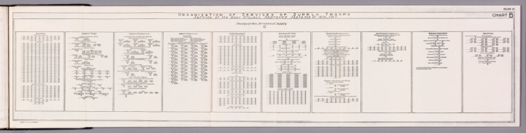
|
Author
Pershing, John J. (John Joseph), 1860-1948
Full Title
Organization of services of supply troops : Service of the Rear Project, approved September 18th, 1917. H. Doc. 626, 66-2.
List No
14379.017
Note
Military diagram of the general organization of army, corps and divisional troops during World War I. Features headquarters services of supply in 1917. Includes explanatory notes. Black and white engraving. Diagram is 21 x 96 cm, on sheet 23 x 97 cm.
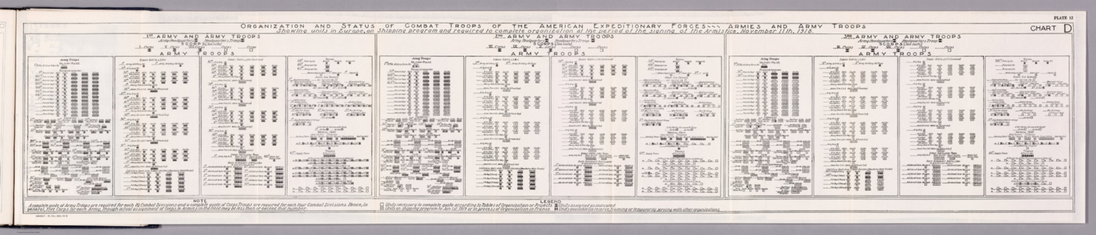
Author
Pershing, John J. (John Joseph), 1860-1948
Full Title
Organization and status of combat troops of the American Expeditionary Forces : Showing units in Europe, on Shipping Program and required to complete organization of the period of the signing of the Armistice. H. Doc. 626, 66-2.
List No
14379.018
Note
Military diagram of the organization and status of combat troops of the American Expeditionary Forces during World War I. Features the Commander in Chief and staff, as well as the First, Second and Third Armies. Includes a legend and explanatory notes. Black and white engraving. Diagram is 21 x 29 cm, on sheet 23 x 32 cm.
Author
Pershing, John J. (John Joseph), 1860-1948
Full Title
Organization and status of combat troops of the American Expeditionary Forces, armies and army troops : Showing units in Europe, on Shipping Program and required to complete organization of the period of the signing of the Armistice, November 11th, 1918. H. Doc. 626, 66-2.
List No
14379.019
Note
Military diagram of the organization and status of army combat troops within the American Expeditionary Forces during World War I. Features units in Europe, in the Shipping Program and those required to complete organization during the period of the Armistice signing in 1918. Includes a legend and explanatory notes. Black and white engraving. Diagram is 21 x 29 cm, on sheet 23 x 32 cm.
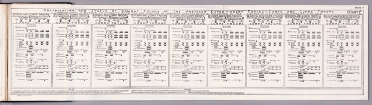
Author
Pershing, John J. (John Joseph), 1860-1948
Full Title
Organization and status of combat troops of the American Expeditionary Forces, crops and corps troops : Showing units in Europe, on Shipping Program and required to complete organization of the period of the signing of the Armistice, November 11th, 1918. H. Doc. 626, 66-2.
List No
14379.020
Note
Military diagram of the organization and status of crops combat troops within the American Expeditionary Forces during World War I. Features units in Europe, in the Shipping Program and those required to complete organization during the period of the Armistice signing in 1918. Includes a legend and explanatory notes. Black and white engraving. Diagram is 21 x 83 cm, on sheet 23 x 86 cm.
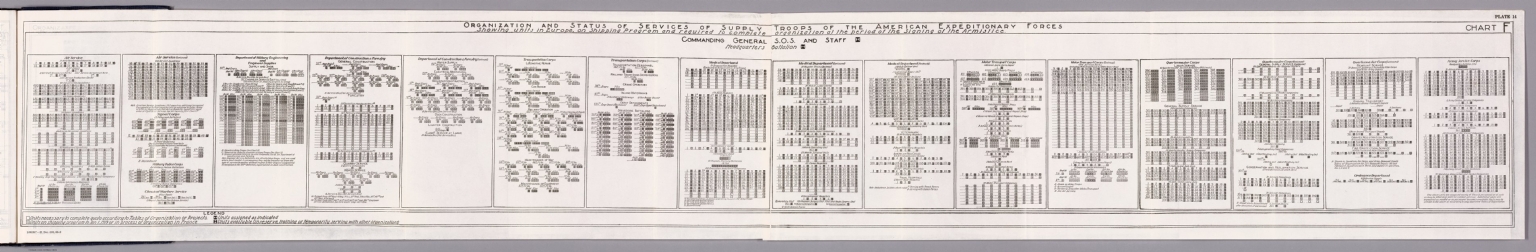
Author
Pershing, John J. (John Joseph), 1860-1948
Full Title
Organization and status of services of supply troops of the American Expeditionary Forces : Showing units in Europe, on Shipping Program and required to complete organization of the period of the signing of the Armistice. H. Doc. 626, 66-2.
List No
14379.021
Note
Military diagram of the organization and status of services of supply troops within the American Expeditionary Forces during World War I. Features units in Europe, in the Shipping Program and those required to complete organization during the period of the Armistice signing in 1918. Includes a legend and explanatory notes. Black and white engraving. Diagram is 21 x 149 cm, on sheet 23 x 151 cm.
Author
Pershing, John J. (John Joseph), 1860-1948
Full Title
Organization and status of combat troops of the American Expeditionary Forces : Showing units in Europe, on Shipping Program and required to complete organization of the period of the signing of the Armistice. H. Doc. 626, 66-2.
List No
14379.022
Note
Military diagram of the organization and status of combat troops within the American Expeditionary Forces during World War I. Features units in Europe, in the Shipping Program and those required to complete organization during the period of the Armistice signing in 1918. Includes a legend and explanatory notes. Black and white engraving. Diagram is 21 x 29 cm, on sheet 23 x 32 cm.
Author
[Pershing, John J. (John Joseph), 1860-1948, Geological Survey (U.S.)]
Full Title
Map of France superimposed on that of the United States : Showing relative distances and the extent of railroad systems used by the American Expeditionary Forces. House Doc. No. 626; 66th Cong., 2d Sess. Engraved and printed by the U. S. Geological Survey.
List No
14379.023
Note
Military map of France, overlaid upon the United States in order to show the relative distances between different cities. Features the railroad systems used by the American Expeditionary Forces during World War I. Shows political boundaries, cities, drainage, coastlines and islands. Includes a legend, explanatory notes and two bar scales given in kilometers and miles, as well as a compass rose with north oriented toward top of sheet (for the United States). Colored engraving. Map is 20 x 24 cm, on fold-out sheet 23 x 27 cm.
Author
Air Ministry
Full Title
(Covers to) The approach towards a system of imperial air communications. Air Ministry. London : Printed and published by His Majesty's Stationary Office. 1926.
List No
14344.001
Note
Covers to The approach towards a system of imperial air communications. Bound in board, covered in light blue paper, with darker blue tape reinforcing the spine. Front cover includes title and statement of responsibility, as well as the original price: 5s. "Memorandum by the secretary of state for air, laid before the Imperial conference, 1926, together with the Report of the Imperial Air Communications Special Sub-Committee."
Author
[Air Ministry, Hoare, Samuel]
Full Title
(Text Page to) Prefatory note. Samuel Hoare.
List No
14344.004
Note
Preface to The approach towards a system of imperial air communications. Text begins: So much interest has been aroused by the discussions on the development of civil aviation within the Empire which took place at the Imperial Conference, that a demand has arisen for the memorandum circulated by the Air Ministry to the Conference to be made available to the general public.
Author
[Air Ministry, Great Britain. War Office, Great Britain. Ordnance Survey]
Full Title
Aeroplane services of Northern Europe : Services operating in July, 1902 -- Services operating in July, 1926. O.R. 295. War Office, Augst. 1926.
List No
14344.015
Note
Two maps showing air routes in Northern Europe, in July of 1920 and 1926. Features international air routes between major cities. Colored lithograph. Together, maps are 27 x 18 cm, on sheet 33 x 21 cm. Accompanied by descriptive text on pages 5-8.
Author
[Air Ministry, Great Britain. War Office, Great Britain. Ordnance Survey]
Full Title
The first imperial aeroplane routes. O.R. 304. Ordnance Survey 1926. Printed at the War Office, 1926.
List No
14344.019
Note
Map showing the first imperial air routes across North Africa, the Middle East and South Asia in 1926. Shows political boundaries, cities, railways, topography, drainage, coastlines and islands. Relief shown with hachures. Includes latitudinal and longitudinal lines, as well as a legend. Colored lithograph. Map is 29 x 48 cm, on fold-out sheet 33 x 54 cm. Accompanied by descriptive text on pages 5-8.
Author
Air Ministry
Full Title
Comparison of airship lengths. H. M. S. O., Cr.
List No
14344.024
Note
Diagram of airships. Shows a comparison of two different sizes, the R.33 and R.101 models. Includes dimensions. With a horizon line below, and a tower and figure to provide scale. Diagram is 17 x 29 cm, on sheet 21 x 33 cm. Black and white drawing. Followed by a diagram comparing the transverse frames of each airship pictured here.
Author
Air Ministry
Full Title
Comparison of transverse frames. H. M. S. O., Cr.
List No
14344.025
Note
Diagram of transverse frames for the airships pictured in the previous diagram. Shows a comparison of two different sizes, the R.33 and R.101 models. Includes dimensions. With a horizon line below, and figures to provide scale. Black and white drawing. Diagram is 17 x 29 cm, on sheet 21 x 33 cm.
Author
Air Ministry
Full Title
An airship being brought to her shed by a landing party of 250-300 men -- An airship landing to a mooring mast operated by a crew of ten men -- The old mast at Pulham -- the new mast at Cardington.
List No
14344.029
Note
Four views of airships and masts. With buildings and figures to provide scale. Views include explanatory note. Black and white photographs. Together, views are 30 x 39 cm, on fold-out sheet 33 x 43 cm.
Author
[Air Ministry, Great Britain. War Office, Great Britain. Ordnance Survey]
Full Title
Map showing the frequency of thunderstorms during the month of June on the England-Egypt section of the England-India airship route. O.R. 293. War Office, August, 1926.
List No
14344.032
Note
Map showing thunderstorms across Europe and North Africa in June, 1926. Shows thunderstorm frequency (within circled numbers), topography, coastlines and islands. Relief shown with shading. Features international air routes between Cardington, England, and Ismailia, Egypt. Includes a legend and explanatory notes. Colored lithograph. Map is 30 x 38 cm, on fold-out sheet 33 x 42 cm. Accompanied by descriptive text on pages 18-20.
Author
[Air Ministry, Great Britain. War Office, Great Britain. Ordnance Survey]
Full Title
Map showing the percentage frequency of winds of different directions & speeds at 1,500 feet above the ground over Lower Egypt, trans Jordania & Irak in July. O.R. 292. War Office, August, 1926.
List No
14344.033
Note
Map showing winds across North Africa and the Middle East in July, 1926. Shows wind frequency, direction and speed (within circled numbers, which include arrows), topography, coastlines and islands. Relief shown with shading. Features "desirable" international air routes, based upon wind. Includes a legend and explanatory notes. Colored lithograph. Map is 18 x 23 cm, on fold-out sheet 33 x 28 cm. Accompanied by descriptive text on pages 18-20.
Author
[Air Ministry, Great Britain. War Office, Great Britain. Ordnance Survey]
Full Title
Map showing the actual wind and weather over the whole of the England-India airship route on the morning of February 16th 1925. O.R. 308. War Office, 1926.
List No
14344.036
Note
Map showing wind and other weather across Europe, North Africa and the Middle East on the morning of February 16, 1925. Shows wind, temperature and weather, such as clear skies, rain and snow, as well as coastlines and islands. Features international air routes between Cardington, England, and Ismailia, Egypt. Includes latitudinal and longitudinal lines, as well as isobars, a legend and explanatory notes. Colored lithograph. Map is 29 x 43 cm, on fold-out sheet 33 x 48 cm. Accompanied by descriptive text on pages 18-20.
Author
[Air Ministry, Great Britain. War Office, Great Britain. Ordnance Survey]
Full Title
Map showing British air services in 1926. O.R. 306a. Drawn at O.S.O. Printed at the War Office, 1926.
List No
14344.043
Note
Map showing British and other international air routes across Europe, North Africa and the Middle East in 1926. Shows political boundaries, cities, coastlines and islands. Includes latitudinal and longitudinal lines, as well as a legend. Colored lithograph. Map is 28 x 39 cm, on fold-out sheet 33 x 43 cm. Accompanied by descriptive text on pages 23-29.
Author
[Air Ministry, Great Britain. War Office, Great Britain. Ordnance Survey]
Full Title
Map of Australia showing existing and proposed air routes. O.R. 301. War Office, 1926.
List No
14344.048
Note
Map showing both existing and proposed air routes in Australia in 1926. Shows political boundaries, cities, railways, topography, lakes, drainage, coastlines and islands. Relief shown with hachures. Includes latitudinal and longitudinal lines, as well as a legend. Colored lithograph. Map is 32 x 45 cm, on fold-out sheet 33 x 48 cm. Accompanied by descriptive text on pages 29-31.
Author
[Air Ministry, Great Britain. War Office, Great Britain. Ordnance Survey]
Full Title
Map showing existing and proposed aeroplane services in Southern Africa. O.R. 296. War Office, 1926.
List No
14344.051
Note
Map showing both existing and proposed air routes in Southern Africa in 1926. Features British and Belgian routes. Shows political boundaries, cities, railways, topography, lakes, drainage, coastlines and islands. Relief shown with hachures and spot heights. Includes latitudinal and longitudinal lines, as well as a legend, two bar scales and a scale statement. Colored lithograph. Map is 27 x 24 cm, on fold-out sheet 33 x 28 cm. Accompanied by descriptive text on page 32.
Author
[Air Ministry, Great Britain. War Office, Great Britain. Ordnance Survey]
Full Title
Map showing French air services in 1926. O.R. 306b. Drawn at O.S.O. Printed at the War Office, 1926.
List No
14344.054
Note
Map showing both existing and proposed French air routes across Europe, North Africa and the Middle East in 1926. Shows political boundaries, cities, coastlines and islands. Includes latitudinal and longitudinal lines, as well as a legend. Colored lithograph. Map is 28 x 38 cm, on fold-out sheet 33 x 44 cm. Accompanied by descriptive text on pages 34-35.
Author
[Air Ministry, Great Britain. War Office, Great Britain. Ordnance Survey]
Full Title
Map showing German air services in 1926. O.R. 306c. Drawn at O.S.O. Printed at the War Office, 1926.
List No
14344.057
Note
Map showing both existing and proposed German air routes across Europe, North Africa and the Middle East in 1926. Shows political boundaries, cities, coastlines and islands. Includes latitudinal and longitudinal lines, as well as a legend. Colored lithograph. Map is 28 x 38 cm, on fold-out sheet 33 x 44 cm. Accompanied by descriptive text on pages 36-37.
Author
[Air Ministry, Great Britain. War Office, Great Britain. Ordnance Survey]
Full Title
Map showing the United States of America : Air routes in the U.S.A. shown in blue. O.R. 303. Ordnance Survey, 1926. Printed at the War Office, 1926.
List No
14344.060
Note
Map showing both existing and proposed American air routes across the United States in 1926. Shows political boundaries, cities, railways, topography, lakes, drainage, coastlines and islands. Relief shown pictorially. Includes latitudinal and longitudinal lines, as well as a legend. Colored lithograph. Map is 27 x 40 cm, on fold-out sheet 33 x 44 cm. Accompanied by descriptive text on pages 38-39.
Author
[Air Ministry, Great Britain. War Office, Great Britain. Ordnance Survey]
Full Title
Map showing existing and proposed air routes in Soviet Russia and adjacent areas. O.R. 305. Ordnance Survey, 1926. Printed at the War Office, 1926.
List No
14344.064
Note
Map showing both existing and proposed air routes across Soviet Russia and the vicinity in 1926. Features Soviet Russian, German and British routes. Shows political boundaries, cities, railways, topography, lakes, drainage, coastlines and islands. Relief shown pictorially. Includes latitudinal and longitudinal lines, as well as a legend. Colored lithograph. Map is 26 x 34 cm, on fold-out sheet 33 x 41 cm. Accompanied by descriptive text on pages 40-42.
Author
[Air Ministry, Great Britain. War Office, Great Britain. Ordnance Survey]
Full Title
Map showing miscellaneous air services in 1926. O.R. 306d. Drawn at O.S.O. Printed at the War Office, 1926.
List No
14344.067
Note
Map showing both existing and proposed air routes across Europe, North Africa and the Middle East in 1926. Features air routes by different nations, such as Hungary, Sweden and Spain. Shows cities, coastlines and islands. Includes latitudinal and longitudinal lines, as well as a legend. Colored lithograph. Map is 28 x 38 cm, on fold-out sheet 33 x 44 cm. Accompanied by descriptive text on pages 44-45.
Author
[Air Ministry, Great Britain. War Office, Great Britain. Ordnance Survey]
Full Title
Map showing meteorological stations on air routes over South-East England. O.R. 307. War Office, 1926.
List No
14344.078
Note
Map showing meteorological stations along air routes across southeastern England in 1926. Shows political boundaries, cities, railways, topography, drainage, coastlines and islands. Includes a legend. Colored lithograph. Map is 13 x 17 cm, on sheet 21 x 30 cm. Accompanied by descriptive text on pages 57-62.
Author
[Air Ministry, Great Britain. War Office, Great Britain. Ordnance Survey]
Full Title
Map showing areas in which main imperial airship routes will probably develop. Based on a preliminary survey of meteorological conditions & topography. O.R. 291. War Office, August, 1926.
List No
14344.094
Note
World map showing projected areas of development for imperial airship routes, as of 1926. Colored lithograph. Includes latitudinal and longitudinal lines. Map is 19 x 30 cm, on fold-out sheet 30 x 35 cm. Accompanied by descriptive text on pages 74-77.
Author
[Air Ministry, Great Britain. War Office, Great Britain. Ordnance Survey]
Full Title
Map of the area of the England-India airship route showing meteorological stations from which observations are circulated daily, and high land which airships will normally avoid. O.R. 300. War Office, August, 1926.
List No
14344.099
Note
Map showing meteorological stations along the England-India airship route, which covers Europe, North Africa and the Middle East in 1926. Shows meteorological station locations, topography, coastlines and islands. Relief shown with shading. Colored lithograph. Includes latitudinal and longitudinal lines. Map is 32 x 48 cm, on fold-out sheet 34 x 53 cm. Accompanied by descriptive text on pages 77-81.
Author
[Air Ministry, Great Britain. War Office, Great Britain. Ordnance Survey]
Full Title
Map of Canada : Areas in Canada covered by aerial photograhps taken prior to July 1st 1926, shown in red. O.R. 302. Ordnance Survey, 1926. Printed at the War Office, 1926.
List No
14344.103
Note
Map showing the areas in Canada covered by aerial photographs taken prior to July 1, 1926. Shows political boundaries, cities, railways, topography, lakes, drainage, coastlines and islands. Relief shown with hachures. Colored lithograph. Includes latitudinal and longitudinal lines. Map is 28 x 42 cm, on fold-out sheet 34 x 46 cm. Accompanied by descriptive text on pages 82-86.
Author
[Air Ministry, Great Britain. War Office, Great Britain. Ordnance Survey]
Full Title
Map of the world showing existing and proposed air transport routes. O.R. 299. War Office, 1926.
List No
14344.114
Note
World map showing existing and proposed air routes in 1926. Shows political boundaries, cities, lakes, drainage, coastlines, islands and steamship routes. Colored lithograph. Includes latitudinal and longitudinal lines, as well as a legend. Map is 34 x 61 cm, on fold-out sheet 44 x 66 cm.
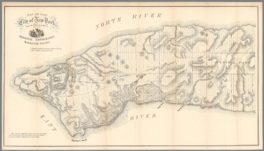
Author
Viele, Egbert L.
Full Title
(Covers to) State of New York. No. 49. In Senate, Feb. 3, 1859. Report of the Select Committee appointed to investigate the Health Department of the City of New York.
List No
10157.001
Note
This map is an early version of the larger map that became Viele's 1865 "Topographical Map of the City of New York. Showing Original Water Courses and Made Land" (see our various copies). It only shows lower Manhattan and has less detail than the later expanded map, but it does show Viele's methodology and the beginnings of what would become his great historical drainage map of the city. It was published in a New York State Senate government document and was prepared by Viele to show before the Senate during his testimony on the sanitary conditions of the city.
Author
Viele, Egbert L.
Full Title
(Title page to) State of New York. No. 49. In Senate, Feb. 3, 1859. Report of the Select Committee appointed to investigate the Health Department of the City of New York.
List No
10157.002
Note
This map is an early version of the larger map that became Viele's 1865 "Topographical Map of the City of New York. Showing Original Water Courses and Made Land" (see our various copies). It only shows lower Manhattan and has less detail than the later expanded map, but it does show Viele's methodology and the beginnings of what would become his great historical drainage map of the city. It was published in a New York State Senate government document and was prepared by Viele to show before the Senate during his testimony on the sanitary conditions of the city.
Author
Viele, Egbert L.
Full Title
Improved Sanitary arrangement of Receiving Basins and Dumping Stations At the Terminal of Sewers and River Fronts.
List No
10157.003
Note
Diagram accompanying the report.
Author
Viele, Egbert L.
Full Title
Map of the City of New York from the Battery to 80th St. showing the Original Topography of Manhattan Island. Prepared to accompany the testimony of Egbert L. Viele Esq. before the Sanitary committee of the Senate. Note: This map is compiled from old Surveys and records, and is intended to exhibit the general localities of the original drainage streams, without defining the precise points at which they would intersect the Streets and Avenues.
List No
10157.004
Note
This map is an early version of the larger map that became Viele's 1865 "Topographical Map of the City of New York. Showing Original Water Courses and Made Land" (see our various copies). It only shows lower Manhattan and has less detail than the later expanded map, but it does show Viele's methodology and the beginnings of what would become his great historical drainage map of the city. It was published in a New York State Senate government document and was prepared by Viele to show before the Senate during his testimony on the sanitary conditions of the city.
Author
U.S. Department of Commerce, Office of Area Development, Business and Defense Services Administration
Full Title
Plate 21. Areas Susceptible of Reclamation in San Francisco Bay Area.
List No
9494.033
Note
Black and white.
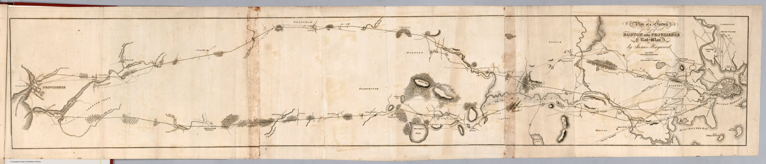
Author
Hayward, James
Full Title
(Title Page to) Report of the Board of Commissioners, of Internal Improvement in Relation to the Examination of Sundry Routes for a Railway from Boston to Providence. With a Memoir of the Survey. Senate No. 4. Boston: Dutton & Wentworth...Printers to the State ... 1828. (with) Plan of A Survey For the Proposed Boston and Providence Rail-Way. by James Hayward. Jan. 1828. Annin & Smith.
List No
0324.001
Note
Earliest Rairoad map in LOC collection. Sabin provides report publication data. Map is uncolored and measures 19x106 at a scale of 1:63,360 (1 inch=1 mile).
Author
Hayward, James
Full Title
(Text Page to) Commonwealth of Massachusetts. Paul Willard, Clerk. Jan. 26, 1828. To His Excellency Levi Lincoln, Joshiah J. Fiske, Chairman, Boston, January 24, 1828. (to accompany) Report of the Board of Commissioners, of Internal Improvement in Relation to the Examination of Sundry Routes for a Railway from Boston to Providence.
List No
0324.002
Note
Text on 2 pages. Earliest Rairoad map in LOC collection. Sabin provides report publication data. Map is uncolored and measures 19x106 at a scale of 1:63,360 (1 inch=1 mile).
Author
Hayward, James
Full Title
(Text Page to) Message. (to accompany) Report of the Board of Commissioners, of Internal Improvement in Relation to the Examination of Sundry Routes for a Railway from Boston to Providence.
List No
0324.003
Note
Message to the Senate and House of Representatives by Levi Lincoln. Jan 25, 1828. Earliest Rairoad map in LOC collection. Sabin provides report publication data. Map is uncolored and measures 19x106 at a scale of 1:63,360 (1 inch=1 mile).
Author
Hayward, James
Full Title
(Text Page to) Message. (to accompany) Report of the Board of Commissioners, of Internal Improvement in Relation to the Examination of Sundry Routes for a Railway from Boston to Providence.
List No
0324.004
Note
Message to the Senate and House of Representatives by Levi Lincoln. Jan 25, 1828. Earliest Rairoad map in LOC collection. Sabin provides report publication data. Map is uncolored and measures 19x106 at a scale of 1:63,360 (1 inch=1 mile).
Author
Hayward, James
Full Title
(Text Page to) Message. (to accompany) Report of the Board of Commissioners, of Internal Improvement in Relation to the Examination of Sundry Routes for a Railway from Boston to Providence.
List No
0324.005
Note
Message to the Senate and House of Representatives by Levi Lincol. Jan 25, 1828. Earliest Rairoad map in LOC collection. Sabin provides report publication data. Map is uncolored and measures 19x106 at a scale of 1:63,360 (1 inch=1 mile).
Author
Hayward, James
Full Title
Plan of a survey for the proposed Boston and Providence rail way. By James Hayward. Jan. 1828. (engraved by) Annin & Smith. (to accompany) Report of the Board of Commissioners, of Internal Improvement in Relation to the Examination of Sundry Routes for a Railway from Boston to Providence.
List No
0324.006
Note
Map is uncolored. Shows 2 possible routes between Boston and Providence. Relief shown by hachures.
Author
[Bennett, Edward H., Committee of Forty, on the Reconstruction of San Francisco, Burnham, Daniel Hudson, 1846-1912]
Full Title
(Covers to) Plan of Proposed Street Changes in the Burned District and Other Sections of San Francisco. Joint Report of Committee on Extending, Widening and Grading Streets and Committee on Burnham Plans. Subcommittees of the Committee of Forty, on the Reconstruction of San Francisco. Submitted to Board of Supervisors May, 1906.
List No
0872.001
Note
Dark brown worn and damaged cover with gilt text on front, "Plan of Proposed Street Changes in the Burned District and Other Sections of San Francisco".
Author
[Bennett, Edward H., Committee of Forty, on the Reconstruction of San Francisco, Burnham, Daniel Hudson, 1846-1912]
Full Title
San Francisco. Plan of Proposed Steet Changes in the Burned District and Other Sections.
List No
0872.002
Note
In pocket.
Author
[Bennett, Edward H., Committee of Forty, on the Reconstruction of San Francisco, Burnham, Daniel Hudson, 1846-1912]
Full Title
(Title Page) Plan of Proposed Street Changes in the Burned District and Other Sections of San Francisco. Joint Report of Committee on Extending, Widening and Grading Streets and Committee on Burnham Plans. Subcommittees of the Committee of Forty, on the Reconstruction of San Francisco. Submitted to Board of Supervisors May, 1906.
List No
0872.003
Author
[Bennett, Edward H., Committee of Forty, on the Reconstruction of San Francisco, Burnham, Daniel Hudson, 1846-1912]
Full Title
(Text Page) The Hicks-Judd Company (Logo). Preface.
List No
0872.004
Author
[Bennett, Edward H., Committee of Forty, on the Reconstruction of San Francisco, Burnham, Daniel Hudson, 1846-1912]
Full Title
(Text Page) Subcommittees of the Committee of Forty - on the Reconstruction of San Francisco.
List No
0872.005
Author
[Bennett, Edward H., Committee of Forty, on the Reconstruction of San Francisco, Burnham, Daniel Hudson, 1846-1912]
Full Title
(Index Page) Index.
List No
0872.006
Author
[Bennett, Edward H., Committee of Forty, on the Reconstruction of San Francisco, Burnham, Daniel Hudson, 1846-1912]
Full Title
(Index Page) Index.
List No
0872.007
Author
[Bennett, Edward H., Committee of Forty, on the Reconstruction of San Francisco, Burnham, Daniel Hudson, 1846-1912]
Full Title
Fifty Vara Survey.
List No
0872.008
Author
[Bennett, Edward H., Committee of Forty, on the Reconstruction of San Francisco, Burnham, Daniel Hudson, 1846-1912]
Full Title
Fifty Vara Survey (continued).
List No
0872.009
|