|
Author
[Bouchette, Joseph Jun., Cauchon, Joseph, Canada Crown Lands Department]
Full Title
(Covers to) Appendix to report of the Commissioner of Crown Lands, part II : Maps of Canada
List No
15897.001
Author
[Bouchette, Joseph Jun., Cauchon, Joseph, Canada Crown Lands Department]
Full Title
(Title page to) Appendix to report of the Commissioner of Crown Lands, part II : Maps of Canada
List No
15897.002
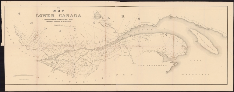
Author
[Bouchette, Joseph Jun., Cauchon, Joseph, Canada Crown Lands Department]
Full Title
No. 1 Map of Lower Canada : shewing the proposed land agencies and the townships distinct from the seigniories
List No
15897.003
Author
[Bouchette, Joseph Jun., Cauchon, Joseph, Canada Crown Lands Department]
Full Title
No. 2 Map of Upper Canada Shewing the Proposed Land Agency Divisions.
List No
15897.004
Author
[Bouchette, Joseph Jun., Cauchon, Joseph, Canada Crown Lands Department]
Full Title
No. 3 Map of the counties of Gaspe and Bonaventure : exhibiting the lands adjudicated, unsurveyed, Clergy Reserves &c. &c. &c.
List No
15897.005
Author
[Bouchette, Joseph Jun., Cauchon, Joseph, Canada Crown Lands Department]
Full Title
No. 4 Plan of the River Saguenay
List No
15897.006
Author
[Bouchette, Joseph Jun., Cauchon, Joseph, Canada Crown Lands Department]
Full Title
No. 5 Plan of the St. Maurice Territory
List No
15897.007
Author
[Bouchette, Joseph Jun., Cauchon, Joseph, Canada Crown Lands Department]
Full Title
No. 6 Map of the Ottawa and Huron Territory
List No
15897.008
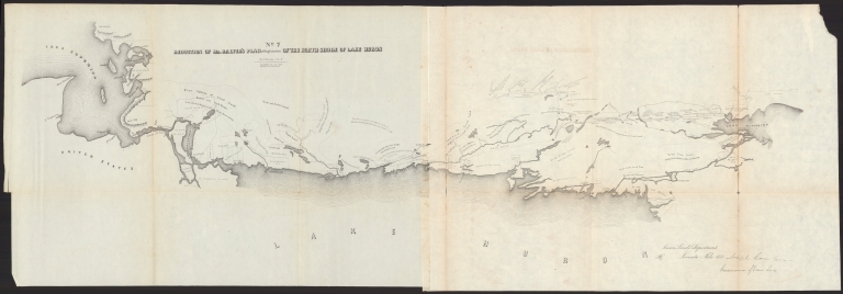
Author
[Bouchette, Joseph Jun., Cauchon, Joseph, Canada Crown Lands Department]
Full Title
No. 7.Reduction of Mr. Salter's plan of exploration of the north shore of Lake Huron
List No
15897.009
Note
Shows Indian reserves, with notes about surface features, soils and forests
Author
[Devine, Thomas, Cauchon, Joseph, Canada Crown Lands Department]
Full Title
(No. 8) Map of the North West Part of Canada Indian Territories & Hudson's Bay.
List No
15897.010
Note
See our 15873.000 for a geologically colored copy.
Author
Espy, James P.
Full Title
Covers to) Espy's report on meteorology, to the Secreatary of the Navy.
List No
15876.001
Author
Espy, James P.
List No
15876.002
Author
Espy, James P.
Full Title
(Composite text to) Espy's report on meteorology, to the Secreatary of the Navy.
List No
15876.003
Author
Espy, James P.
Full Title
April 1st 1843. 3.P.M. Chart Illustrating The Weather 1843
List No
15876.004
Author
Espy, James P.
Full Title
April 2d. 1843 3 P.M. Chart Illustrating The Weather 1843
List No
15876.005
Author
Espy, James P.
Full Title
21st. April 1843 3 P.M. Chart Illustrating The Weather 1843
List No
15876.006
Author
Espy, James P.
Full Title
22d. April 1843 3 P.M. Chart Illustrating The Weather 1843
List No
15876.007
Author
Espy, James P.
Full Title
23d. April 1843 3 P.M. Chart Illustrating The Weather 1843
List No
15876.008
Author
Espy, James P.
Full Title
24th. April 1843 3 P.M. Chart Illustrating The Weather 1843
List No
15876.009
Author
Espy, James P.
Full Title
25th. April 1843 3 P.M. Chart Illustrating The Weather 1843
List No
15876.010
Author
Espy, James P.
Full Title
26th. April 1843 3 P.M. Chart Illustrating The Weather 1843
List No
15876.011
Author
Espy, James P.
Full Title
April 27th 3 P.M. 1843 Chart Illustrating The Weather 1843
List No
15876.012
Author
Espy, James P.
Full Title
April 28th 3 P.M. 1843 Chart Illustrating The Weather 1843
List No
15876.013
Author
District of Columbia. Board of Education.
Full Title
(Title Page to) 57th congress, 1st session. House of Representatives. Document no. 7. Report of the Commissioners of the District of Columbia for the year ended June 30, 1901. Vol. IV. [Report of the Board of Education.] Washington: Government printing office, 1902.
List No
14492.001
Note
Title page to 57th congress, 1st session. House of Representatives. Document no. 7. Report of the Commissioners of the District of Columbia for the Year Ended June 30, 1901. Sewn binding. No cover. (Page number inferred.)
Author
District of Columbia. Board of Education.
Full Title
Map of the District of Columbia showing location of schools. The Norris Peters Co. Photolitho. Washington, D.C.
List No
14492.005
Note
Map representing the locations of "white" and "colored" schools, as well as unoccupied schools and lots in Washington D.C. Shows topography, cities, railways, roads, bridges, parks, bodies of water, drainage, shoreline and islands. Relief shown by contour lines. Includes a legend, bar scale given in feet, and compass rose with north oriented toward upper left of sheet. With informational text and citations. Colored lithograph. Map is 54 x 72 cm, on fold-out sheet 58 x 77 cm.
Author
United States. Office of War Information
Full Title
(Title Page to) Japanese evacuation from the West Coast, 1942 : Final report. United States Government Printing Office, Washington : 1943.
List No
14375.003
Note
Title page to Japanese evacuation from the West Coast, 1942 : Final report. Includes seal of the United States of America War Office. "For sale by the Superintendent of Documents, U. S. Government Printing Office, Washington, D. C. (Page number inferred.)
Author
[United States. Office of War Information, United States. Army. Western Defense Command, United States. Wartime Civil Control Administration]
Full Title
Geographical distribution : Japanese population, United States : 1940. Western Defense Command and Fourth Army, Wartime Civil Control Administration.
List No
14375.026
Note
Map of the United States, featuring the geographical distribution of the Japanese American population in the United States in 1940. Shows political boundaries and the number of Japanese Americans in each state, utilizing data visualization to illustrate population density. Includes explanatory note. In color. Map is 15 x 23 cm. Figure 5-b. Appears in Part IV : Evacuation - its operational technique, Chapter VIII : Development and execution of the evacuation plan. (Page number inferred.)
Author
[United States. Office of War Information, United States. Army. Western Defense Command, United States. Wartime Civil Control Administration]
Full Title
Japanese population : Western defense command area : 1940. Western Defense Command and Fourth Army, Wartime Civil Control Administration.
List No
14375.027
Note
Map of the western United States, featuring the Japanese population in the Western Defense Command Area in 1940. Shows political boundaries and the approximate number of Japanese Americans in each state, utilizing data visualization to illustrate population density. Includes a legend. With four inset maps: Seattle metropolitan area -- Portland metropolitan area -- San Francisco Bay Area -- Los Angeles metropolitan area. Black and white. Map is 14 x 12 cm, on sheet 23 x 15 cm. "Source: U. S. Bureau of the Census." Figure 6. Appears in Part IV : Evacuation - its operational technique, Chapter VIII : Development and execution of the evacuation plan.
Author
United States. Office of War Information
Full Title
Age and nativity of Japanese in Arizona, California, Oregon and Washington : 1940.
List No
14375.028
Note
Chart featuring the age and place of birth (foreign vs. native) for Japanese Americans in Arizona, California, Oregon and Washington, as of 1940. Figure 7. Appears in Part IV : Evacuation - its operational technique, Chapter VIII : Development and execution of the evacuation plan.
Author
[United States. Office of War Information, United States. Army. Western Defense Command, United States. Wartime Civil Control Administration]
Full Title
Exclusion areas : Japanese evacuation program. Western Defense Command and Fourth Army, Wartime Civil Control Administration.
List No
14375.030
Note
Map of the western United States, featuring the exclusion areas during the evacuation of the Japanese population from the Pacific Coast. Shows political boundaries and the assembly and relocation centers. Includes a legend. With four inset maps: Seattle and vicinity -- Portland and vicinity -- San Francisco and vicinity -- Los Angeles and vicinity. Black and white. Map is 15 x 12 cm, on sheet 23 x 15 cm. Figure 9. Appears in Part IV : Evacuation - its operational technique, Chapter VIII : Development and execution of the evacuation plan.
Author
[United States. Office of War Information, United States. Army. Western Defense Command, United States. Wartime Civil Control Administration]
Full Title
Net voluntary movement of Japanese : Western Defense Command Area, March 12th to June 5th, 1942. Western Defense Command and Fourth Army, Wartime Civil Control Administration.
List No
14375.033
Note
Map of the United States, featuring the allegedly voluntary migration of Japanese Americans in the Western Defense Command Area, from March 12th to June 5th, 1942. Shows political boundaries and utilizes data visualization to illustrate population density within the migration to different places. Includes a legend and explanatory note. Black and white. Map is 11 x 16 cm, on sheet 15 x 23 cm. Figure 11. Appears in Part IV : Evacuation - its operational technique, Chapter IX : Voluntary migration.
Author
United States. Office of War Information
Full Title
Assembly center sites.
List No
14375.042
Note
Map featuring assembly center sites in the western United States. Shows political boundaries, cities, roads, national parks, bodies of water, drainage and coastline. Includes a table: Maximum Japanese population and dates of occupation of assembly centers. In color. Map is 28 x 19 cm, on double sheet 31 x 23 cm. Figure 15. Appears in Part V : Assembly center operations, Chapter XIII : Assembly center location, construction and equipment.
Author
United States. Office of War Information
Full Title
Location of assembly center : Tanforan.
List No
14375.043
Note
Map featuring the assembly center location in Tanforan of San Bruno, California. Shows the vicinity's political boundaries, cities, railways, roads, topography, bodies of water and drainage. Relief shown with hachures and spot heights. Includes a legend, explanatory notes and bar scale given in miles. In color. Map is 14 x 11 cm, on sheet 23 x 15 cm. Figure 14-f. Appears in Part V : Assembly center operations, Chapter XIII : Assembly center location, construction and equipment.
Author
United States. Office of War Information
Full Title
Tanforan Assembly Center.
List No
14375.062
Note
Photograph featuring the Tanforan Assembly Center of San Bruno, California. Shows the site with its surrounding buildings, roads, topography and vegetation. Bird's-eye view in black and white. View is 11 x 16 cm, on sheet 15 x 23 cm. Figure 16-m. Appears in Part V : Assembly center operations, Chapter XIII : Assembly center location, construction and equipment.
Author
United States. Office of War Information
Full Title
War relocation project sites.
List No
14375.076
Note
Map of the United States featuring the war relocation project sites. Shows political boundaries, cities and roads. Includes a legend. In color. Map is 14 x 18 cm, on sheet 15 x 23 cm. Figure 21. With descriptive text on facing page. Appears in Part VI : Relocation of evacuees, Chapter XXI : The construction and equipment of relocation centers.
Author
United States. Office of War Information
Full Title
Location of war relocation center : Manzanar.
List No
14375.078
Note
Map featuring the war relocation center in Manzanar of Owens Valley, California. Shows the vicinity's political boundaries, cities, railways, roads, topography, bodies of water and drainage. Relief shown with hachures. Includes a legend, explanatory notes and bar scale given in miles. In color. Map is 14 x 9 cm, on sheet 23 x 15 cm. Figure 20-g. Appears in Part VI : Relocation of evacuees, Chapter XXI : The construction and equipment of relocation centers.
Author
[United States. Office of War Information, United States. Army. Western Defense Command, United States. Wartime Civil Control Administration]
Full Title
Japanese evacuation program : Exclusion areas. Western Defense Command and Fourth Army, Wartime Civil Control Administration, Statistical Division.
List No
14375.090
Note
Map of the western United States, featuring the "exclusion areas" for Japanese Americans during World War II. Shows political boundaries, assembly and relocation centers, bodies of water, coastline and islands. Includes a legend and explanatory note. With four inset maps: Seattle and vicinity -- Portland and vicinity -- San Francisco and vicinity -- Los Angeles and vicinity -- Sacramento and vicinity. In color. Map is 32 x 32 cm, on fold-out sheet 45 x 36 cm. Figure 27. Appears in Part VI : Relocation of evacuees, Chapter XXII : Transfer of evacuees from assembly to relocation centers.
Author
[United States. Office of War Information, United States. Army. Western Defense Command, United States. Wartime Civil Control Administration]
Full Title
Japanese evacuation program : Assembly center destinations. Western Defense Command and Fourth Army, Wartime Civil Control Administration, Statistical Division.
List No
14375.091
Note
Map of the western United States, featuring the assembly center destinations for Japanese Americans during World War II. Shows political boundaries, assembly and relocation centers, bodies of water, coastline and islands. Includes a legend and explanatory note. With five inset maps: Seattle and vicinity -- Portland and vicinity -- San Francisco and vicinity -- Los Angeles and vicinity -- Sacramento and vicinity. In color. Map is 32 x 32 cm, on fold-out sheet 45 x 36 cm. Figure 27. Appears in Part VI : Relocation of evacuees, Chapter XXII : Transfer of evacuees from assembly to relocation centers.
Author
[United States. Office of War Information, United States. Army. Western Defense Command, United States. Wartime Civil Control Administration]
Full Title
Japanese evacuation program : Relocation center destinations. Western Defense Command and Fourth Army, Wartime Civil Control Administration, Statistical Division.
List No
14375.092
Note
Map of the western United States, featuring the relocation center destinations for Japanese Americans during World War II. Shows political boundaries, assembly and relocation centers, bodies of water, coastline and islands. Includes a legend and explanatory note. With five inset maps: Seattle and vicinity -- Portland and vicinity -- San Francisco and vicinity -- Los Angeles and vicinity -- Sacramento and vicinity. In color. Map is 32 x 32 cm, on fold-out sheet 45 x 36 cm. Figure 27. Appears in Part VI : Relocation of evacuees, Chapter XXII : Transfer of evacuees from assembly to relocation centers.
Author
[United States. Office of War Information, United States. Army. Western Defense Command, United States. Wartime Civil Control Administration]
Full Title
Japanese population, assembly and relocation centers : Western Defense Command Area : June 7, 1942. Western Defense Command and Fourth Army, Wartime Civil Control Administration, Statistical Division.
List No
14375.101
Note
Map featuring the Japanese American population at assembly and relocation centers in the Western Defense Command Area, as of June 7, 1942. Shows political boundaries, bodies of water, drainage, coastline and islands. Includes a legend. Map is 16 x 12 cm, on sheet 23 x 15 cm. Figure 36. Appears in Part VIII : Statistical and fiscal summary, Chapter XXVIII : Statistical summary.
Author
Pershing, John J. (John Joseph), 1860-1948
Full Title
(Title Page to) Final report of Gen. John J. Pershing, Commander-In-Chief, American Expeditionary Forces.
List No
14379.002
Note
Title page to Final report of Gen. John J. Pershing. Includes imprint. With the seal of the United States of America War Office. (Page number inferred.)
Author
[Pershing, John J. (John Joseph), 1860-1948, Geological Survey (U.S.)]
Full Title
"The Second Battle of the Marne" : Map showing sectors held and grounds advanced over by American divisions. House Doc. No. 626; 66th Cong., 2d Sess. Engraved and printed by the U. S. Geological Survey.
List No
14379.008
Note
Military map of Marne, France, during World War I. Features areas held and grounds advanced by American troops in the "The Second Battle of the Marne" of 1918. Shows cities, battle lines, military jurisdictions and drainage. Includes a legend, explanatory notes and bar scale given in kilometres. With inset map: [27 Div]. Colored engraving. Map is 18 x 24 cm, on fold-out sheet 23 x 27 cm. "Information from data available in records of G-3, G.H.Q."
Author
[Pershing, John J. (John Joseph), 1860-1948, Geological Survey (U.S.)]
Full Title
St. Mihiel Offensive, September, 1918 : Map showing daily position of front line. House Doc. No. 626; 66th Cong., 2d Sess. Engraved and printed by the U. S. Geological Survey.
List No
14379.009
Note
Military map of Saint-Mihiel, France, during World War I. Features the daily position of the front line in the "St. Mihiel Offensive" of 1918. Shows political boundaries, cities, forts, churches, mills, railways, roads, canals, topography, forests, bodies of water and drainage. Includes a legend, explanatory notes and two bar scales given in kilometres and miles. Indexed to indicate military jurisdictions. Colored engraving. Map is 23 x 33 cm, on fold-out sheet 30 x 42 cm.
Author
[Pershing, John J. (John Joseph), 1860-1948, Geological Survey (U.S.)]
Full Title
Map showing successive German defensive systems. House Doc. No. 626; 66th Cong., 2d Sess. Engraved and printed by the U. S. Geological Survey.
List No
14379.010
Note
Military map of France, Germany and Belgium during World War I. Features German defensive systems of 1918. Shows political boundaries, cities, battle lines, military jurisdictions, bodies of water, drainage and coastline. Includes a legend, explanatory notes and bar scale given in kilometres. Colored engraving. Map is 20 x 20 cm, on fold-out sheet 23 x 23 cm.
Author
[Pershing, John J. (John Joseph), 1860-1948, Geological Survey (U.S.)]
Full Title
Meuse-Argonne Offensive, September 26 to November 11, 1918 : Map showing daily position of front line. House Doc. No. 626; 66th Cong., 2d Sess. Engraved and printed by the U. S. Geological Survey.
List No
14379.011
Note
Military map of Meuse and Argonne, France, during World War I. Features the daily position of the front line in the "Meuse-Argonne Offensive" of 1918. Shows political boundaries, cities, forts, churches, mills, railways, roads, canals, topography, forests, bodies of water and drainage. Includes a legend, explanatory notes and two bar scales given in kilometres and miles. Indexed to indicate military jurisdictions. Colored engraving. Map is 65 x 57 cm, on fold-out sheet 69 x 70 cm. "Map Room G-3, G.H.Q."
Author
[Pershing, John J. (John Joseph), 1860-1948, Geological Survey (U.S.)]
Full Title
Map showing sectors held and ground advanced over by American divisions. House Doc. No. 626; 66th Cong., 2d Sess. Engraved and printed by the U. S. Geological Survey.
List No
14379.012
Note
Military map of France, Germany and Belgium during World War I. Features areas held and grounds advanced by American troops of 1918. Shows political boundaries, cities, drainage and coastline. Includes a legend, explanatory notes and bar scale given in kilometres. Indexed to indicate military jurisdictions. Colored engraving. Map is 35 x 34 cm, on fold-out sheet 40 x 36 cm. "Information from data available in records of G-3, G.H.Q."
Author
[Pershing, John J. (John Joseph), 1860-1948, Geological Survey (U.S.)]
Full Title
Diagram illustrating the flow of supplies in the American expeditionary forces. House Doc. No. 626; 66th Cong., 2d Sess. Engraved and printed by the U. S. Geological Survey.
List No
14379.013
Note
Military diagram of the flow of supplies in France by the American expeditionary forces during World War I. Features base depots, intermediate depots and advance depots. Includes explanatory notes. Diagram indexed. Colored engraving. Diagram is 21 x 17 cm, on fold-out sheet 23 x 20 cm.
Author
Pershing, John J. (John Joseph), 1860-1948
Full Title
Absorbtion of German divisions by American Meuse-Argonne Offensive. H. Doc. 626, 66-2.
List No
14379.014
Note
Military diagram of the absorbtion of German divisions by the American Meuse-Argonne Offensive during World War I. Features British, French and Eastern fronts. Includes explanatory notes. Black and white engraving. Diagram is 10 x 12 cm, on sheet 23 x 14 cm.
Author
[Pershing, John J. (John Joseph), 1860-1948, Geological Survey (U.S.)]
Full Title
Principal French ports and railroads used by American expeditionary forces. House Doc. No. 626; 66th Cong., 2d Sess. Engraved and printed by the U. S. Geological Survey.
List No
14379.015
Note
Military map of France during World War I. Features the principal French ports and railroads used by American expeditionary forces. Shows political boundaries, cities, military headquarters and lines, bodies of water, drainage and coastlines. Includes a legend, explanatory note and bar scale given in miles. Colored engraving. Map is 18 x 18 cm, on fold-out sheet 23 x 22 cm.
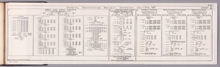
Author
Pershing, John J. (John Joseph), 1860-1948
Full Title
General organization project, approved July 11th, 1917 : Army troops -- Corps troops -- Divisional troops. H. Doc. 626, 66-2.
List No
14379.016
Note
Military diagram of the general organization of army, corps and divisional troops during World War I. Features artillery, cavalry and infantry in 1917. Includes explanatory notes. Black and white engraving. Diagram is 21 x 77 cm, on sheet 23 x 79 cm.
|