|
Author
[Arrowsmith, John, 1790-1873, Franklin, John, 1786-1847, Parry, William Edward, Sir, 1790-1855, M'Clintock, Francis Leopold, Sir, 1819-1907]
Full Title
Sir John Franklin's Arctic discoveries, between Baffin Bay & Cape Bathurst, combined with those of Sir Edward Parry in 1819 and the several searching expeditions, concluding with that of Sir Francis L.M. Clintock in 1859. Constructed by John Arrowsmith. London. Published Jan. 17, 1860, by J. Arrowsmith, 10 Soho Square.
List No
14506.098
Note
Map representing the Arctic Archipelago, also known as Nunavat and the Northwest Territories, Canada. Shows cities, topography, bodies of water, drainage, coastlines, and islands. Relief shown with hachures. Includes a legend, informational and historical text, expedition routes, latitudinal and longitudinal lines, as well as bar scales given in geographical and English miles. With two inset maps: Sketch of Bellot Strait by Capt. Allen Young. -- [Union Bay]. Hand-colored engraving. Map is 52 x 65 cm, on double sheet 56 x 68 cm.
Author
[Arrowsmith, John, 1790-1873, Franklin, John, 1786-1847, Parry, William Edward, Sir, 1790-1855, M'Clintock, Francis Leopold, Sir, 1819-1907]
Full Title
The Arctic Shores of America and part of Asia; shewing the tracks & discoveries of H.M.S. Hela & Griper, from Baffin Bay to Melville Island, commanded by Sir Edw Party 1819 & 20. & of H.M.S. Investigator, from Behring Strait to Mercy Bay, commanded by Capt. McClure, 1850, 51, 52 & 53. Completing the discovery of the North West Passage. also the coasts discovered or examined by the officers of the expeditions sent in search of Sir John Franklin. Drawn from official documents by John Arrowsmith, 10 Soho Square. London, pubd. 1859 by J. Arrowsmith, 10 Soho Square. -- Discoveries in the Arctic Sea, between Baffin Bay & Cape Bathurst, from Official documents. Drawn by J. Arrowsmith. London, pubd. 1859 by J. Arrowsmith, 10 Soho Square.
List No
14506.099
Note
Two maps representing the Arctic, joined at the center. Shows cities, bodies of water, drainage, coastlines, and islands. Includes a legend, informational and historical text, expedition routes, latitudinal and longitudinal lines. Hand-colored engraving. Together, maps are 21 x 64 cm, on double sheet 56 x 68 cm.
Author
[Arrowsmith, John, 1790-1873, Rae, John, 1813-1893, Parry, William Edward, Sir, 1790-1855]
Full Title
Discoveries of the honble. Hudson's Bay Cos. Arctic expedition, to the north of Repulse Bay; conducted by John Rae Esq 1846 & 1847; also his late journey from Repulse Bay, crossing by Franklin Isthmus to Rae Strait 1853-4. Shewing in connection, the discoveries made by Parry, Ross, Back, & the honble. Company's expedition conducted by Dease & Simpson 1838-1839. Adjusted & drawn by John Arrowsmith. London, Pub Jany. 1st 1848, by John Arrowsmith, 10 Soho Square - additions to 1854.
List No
14506.100
Note
Map representing the Arctic Archipelago, also known as Nunavat and the Northwest Territories, Canada. Shows cities, topography, bodies of water, drainage, coastlines, and islands. Relief shown with hachures. Includes a legend, informational and historical text, expedition routes, latitudinal and longitudinal lines, as well as a bar scale given in English miles. With ancillary map: Continuation of the River Quoich to Chesterfield Inlet Discovered & Surveyed by Dr. Rae 1853. Hand-colored engraving. Map is 51 x 61 cm, on double sheet 56 x 68 cm.
Author
[Arrowsmith, John, 1790-1873, Rae, John, 1813-1893]
Full Title
Chart of the Arctic coast, examined by Rae in Spring & Summer 1851. London, Pubd. June 10th 1852 by John Arrowsmith 10 Soho Square. J. Arrowsmith.
List No
14506.101
Note
Map representing the Southern part of the Arctic Archipelago, also known as Nunavat and the Northwest Territories, Canada. Shows cities, topography, bodies of water, drainage, coastlines, and islands. Relief shown with hachures. Includes a legend, historical text, expedition routes, as well as latitudinal and longitudinal lines. Hand-colored engraving. Map is 32 x 72 cm, on fold-out sheet 56 x 80 cm.
Author
Anonymous
Full Title
(Apollo 11 Moon Landing) Le 1er Pas: Ou et Comment (The first pass - where and how)
List No
15968.000
Author
Astrogeology Science Center (Geological Survey)
Full Title
Hadley Rille : EVA - I. Grid interval 250 Meters. July 19971. Hadley-Apennine Landing Site Apollo 15. U.S.G.S, Center for Astrogeology.
List No
13549.002
Note
Geologic image of EVA - I
Author
Astrogeology Science Center (Geological Survey)
Full Title
Hadley Rille : EVA - I. Contour interval 10 Meters. July 19971. Hadley-Apennine Landing Site Apollo 15. U.S.G.S, Center for Astrogeology.
List No
13549.003
Note
Topographic map of EVA - I. Relief shown by contours and spot heights.
Author
Astrogeology Science Center (Geological Survey)
Full Title
Hadley Rille : EVA - II. Grid interval 250 Meters. July 19971. Hadley-Apennine Landing Site Apollo 15. U.S.G.S, Center for Astrogeology.
List No
13549.004
Note
Geologic image of EVA - II.
Author
Astrogeology Science Center (Geological Survey)
Full Title
Hadley Rille : EVA - II. Contour interval 10 Meters. July 19971. Hadley-Apennine Landing Site Apollo 15. U.S.G.S, Center for Astrogeology.
List No
13549.005
Note
Topographic map of f EVA - II. Relief shown by contours and spot heights.
Author
Astrogeology Science Center (Geological Survey)
Full Title
Hadley Rille : EVA - III. Grid interval 250 Meters. July 19971. Hadley-Apennine Landing Site Apollo 15. U.S.G.S, Center for Astrogeology.
List No
13549.006
Note
Geologic image of EVA - III.
Author
Astrogeology Science Center (Geological Survey)
Full Title
Hadley Rille : EVA - III. Contour interval 10 Meters. July 19971. Hadley-Apennine Landing Site Apollo 15. U.S.G.S, Center for Astrogeology.
List No
13549.007
Note
Topographic map of f EVA - III. Relief shown by contours and spot heights.
Author
Astrogeology Science Center (Geological Survey)
Full Title
Hadley Rille : EVA - I, I of 2; EVA - II, I of 3. Grid interval 125 Meters. July 19971. Hadley-Apennine Landing Site Apollo 15. U.S.G.S, Center for Astrogeology.
List No
13549.008
Note
Geologic image of EVA - I, 2 of 2; EVA - II, 1 of 3. Showing geological contacts in white solid and broken lines.
Author
Astrogeology Science Center (Geological Survey)
Full Title
Hadley Rille : EVA - I, 2 of 2; EVA - II, 2 of 3. Grid interval 125 Meters. July 19971. Hadley-Apennine Landing Site Apollo 15. U.S.G.S, Center for Astrogeology.
List No
13549.009
Note
Geologic image of EVA - I, 2 of 2; EVA - II, 2 of 3. Showing geological contacts in white solid and broken lines.
Author
Astrogeology Science Center (Geological Survey)
Full Title
Hadley Rille : EVA - I, 1 of 2; EVA - II, 1 of 3. Grid interval 125 Meters. July 19971. Hadley-Apennine Landing Site Apollo 15. U.S.G.S, Center for Astrogeology.
List No
13549.010
Note
Geologic image of EVA - I, 1 of 2; EVA - II, 1 of 3. Shows nominal LRV transverse and nominal LM sites.
Author
Astrogeology Science Center (Geological Survey)
Full Title
Hadley Rille : EVA - I, 2 of 2; EVA - II, 2 of 3. Grid interval 125 Meters. July 19971. Hadley-Apennine Landing Site Apollo 15. U.S.G.S, Center for Astrogeology.
List No
13549.011
Note
Geologic image of EVA - I, 2 of 2; EVA - II, 2 of 3. Shows nominal LRV transverse and nominal LM sites.
Author
Astrogeology Science Center (Geological Survey)
Full Title
Hadley Rille : EVA - II, 3 of 3. Grid interval 125 Meters. July 19971. Hadley-Apennine Landing Site Apollo 15. U.S.G.S, Center for Astrogeology.
List No
13549.012
Note
Geologic image of EVA - II, 3 of 3. Showing crater Rim and geological contacts in white solid and broken lines.
Author
Astrogeology Science Center (Geological Survey)
Full Title
Hadley Rille : EVA - II, 3 of 3. Grid interval 125 Meters. July 19971. Hadley-Apennine Landing Site Apollo 15. U.S.G.S, Center for Astrogeology.
List No
13549.013
Note
Geologic image of EVA - II, 3 of 3. Shows transverse symbols.
Author
Astrogeology Science Center (Geological Survey)
Full Title
Hadley Rille : South Cluster I of I. Grid interval 125 Meters. July 19971. Hadley-Apennine Landing Site Apollo 15. U.S.G.S, Center for Astrogeology.
List No
13549.014
Note
Geologic image of South Cluster I of I. Shows geological contacts in white solid and broken lines.
Author
Astrogeology Science Center (Geological Survey)
Full Title
Hadley Rille : South Cluster I of I. Grid interval 125 Meters. July 19971. Hadley-Apennine Landing Site Apollo 15. U.S.G.S, Center for Astrogeology.
List No
13549.015
Note
Geologic image of South Cluster I of I.
Author
Astrogeology Science Center (Geological Survey)
Full Title
Hadley Rille : EVA - III, 1 of 2. Grid interval 125 Meters. July 19971. Hadley-Apennine Landing Site Apollo 15. U.S.G.S, Center for Astrogeology.
List No
13549.016
Note
Geologic image of EVA - III, 1 of 2. Shows geological contacts in white solid and broken lines.
Author
Astrogeology Science Center (Geological Survey)
Full Title
Hadley Rille : EVA - III, 1 of 2. Grid interval 125 Meters. July 19971. Hadley-Apennine Landing Site Apollo 15. U.S.G.S, Center for Astrogeology.
List No
13549.017
Note
Geologic image of EVA - III, 1 of 2. Shows Nominal LRV transverse and Nominal LM sites.
Author
Astrogeology Science Center (Geological Survey)
Full Title
Hadley Rille : EVA - III, 2 of 2. Grid interval 125 Meters. July 19971. Hadley-Apennine Landing Site Apollo 15. U.S.G.S, Center for Astrogeology.
List No
13549.018
Note
Geologic image of EVA - III, 2 of 2. Shows geological contacts in white solid and broken lines.
Author
Astrogeology Science Center (Geological Survey)
Full Title
Hadley Rille : EVA - III, 2 of 2. Grid interval 125 Meters. July 19971. Hadley-Apennine Landing Site Apollo 15. U.S.G.S, Center for Astrogeology.
List No
13549.019
Note
Geologic image of EVA - III, 2 of 2. Shows Nominal LRV transverse .
Author
Astrogeology Science Center (Geological Survey)
Full Title
Hadley Rille : Walking transverses : EVA - I, II, III. Grid interval 250 Meters. July 19971. Hadley-Apennine Landing Site Apollo 15. U.S.G.S, Center for Astrogeology.
List No
13549.020
Note
Geologic image of Walking transverses. Shows contingency walking Nominal transverse in broken black lines and geological contacts in white solid and broken white lines.
Author
Astrogeology Science Center (Geological Survey)
Full Title
Hadley Rille : Walking transverses : EVA - I, II, III. Contour interval 10 Meters. July 19971. Hadley-Apennine Landing Site Apollo 15. U.S.G.S, Center for Astrogeology.
List No
13549.021
Note
Topographic map of EVA - I, II, III. Relief shown by contours and spot heights.
Author
Astrogeology Science Center (Geological Survey)
Full Title
Hadley Rille : Walking transverses : EVA - I, III : 1 of 2. EVA - II. Grid interval 125 Meters. July 19971. Hadley-Apennine Landing Site Apollo 15. U.S.G.S, Center for Astrogeology.
List No
13549.022
Note
Geologic image of Walking transverses. Shows contingency walking Nominal transverse in broken black lines and geological contacts in white solid and broken white lines.
Author
Astrogeology Science Center (Geological Survey)
Full Title
Hadley Rille : Walking transverses : EVA - I, III : 1 of 2. EVA - II. Grid interval 125 Meters. July 19971. Hadley-Apennine Landing Site Apollo 15. U.S.G.S, Center for Astrogeology.
List No
13549.023
Note
Geologic image of Walking transverses. Shows contingency walking Nominal transverse and Nominal LM site.
Author
Astrogeology Science Center (Geological Survey)
Full Title
Hadley Rille : Walking transverses : EVA - I, III : 2 of 2. Grid interval 125 Meters. July 19971. Hadley-Apennine Landing Site Apollo 15. U.S.G.S, Center for Astrogeology.
List No
13549.024
Note
Geologic image of Walking transverses. Shows contingency walking Nominal transverse in broken black lines and geological contacts in white solid and broken white lines.
Author
Astrogeology Science Center (Geological Survey)
Full Title
Hadley Rille : Walking transverses : EVA - I, III : 2 of 2. Grid interval 125 Meters. July 19971. Hadley-Apennine Landing Site Apollo 15. U.S.G.S, Center for Astrogeology.
List No
13549.025
Note
Geologic image of Walking transverses. Shows contingency walking Nominal transverse.
Author
Lisle, Brian Orchard
Full Title
GSI... marine seismic leader, 23,000 miles of marine seismic traverse shot in 1961. Geophysical Service International ...
List No
14285.003
Note
Colored map of Australasia representing oil resources. Shows national and state boundaries, oil fields, gas fields, refineries, pipelines, railroads, drainage, coastline, islands, and continental shelf. Includes latitudinal and longitudinal markers along perimeter, as well as a legend, two bar scales (in miles and kilometers) and compass roses. Features illustrations throughout, such as of a kangaroo and a kiwi bird. Lists: Owners of concessions, leases & permits. With tables of data, such as: Australasian field operations & proven reserves. Also, with seven inset maps: Carnarvon Basin; one-well field & shows -- Southern Victoria : Gippsland Basin finds -- Lakes Entrance : Shallow stripper yields -- Sydney : Some gas flows -- S. E. Melanesia -- Great Artesian Basin discoveries : Old Permian Shoreline Trend, Queensland -- New Zealand. Map is 94 x 122 cm, on sheet 97 x 127 cm, folded to 30 x 23 cm.
Author
[Glavnoe Upravlenie Navigat︠s︡ii i Okeanografii Ministerstva Oborony SSSR., Soviet Union. Voenno-Morskoĭ Flot.]
Full Title
Vazhneyshie Russkiie Ekspeditsii po serediny XIX Veka. (To accompany) Atlas okeanov : Tikhiy Okean = Atlas of the Oceans : Pacific Ocean. 1974.
List No
13622.014
Note
Circular map of the Pacific Ocean. Extending from the Arctic region in the north to Antarctic in the south, between continents of Asia, Australia on the west and Americas on the east. Showing the most important Russian Expeditions in the middle of the 19th century with expedition routes. Includes list of exploration date, explorers and expedition routes in color.
Author
[Glavnoe Upravlenie Navigat︠s︡ii i Okeanografii Ministerstva Oborony SSSR., Soviet Union. Voenno-Morskoĭ Flot.]
Full Title
Vazhneyshie ekspeditsii 1804 - 1871 gg. (To accompany) Atlas okeanov : Tikhiy Okean = Atlas of the Oceans : Pacific Ocean. 1974.
List No
13622.018
Note
Map of the major expedition in Pacific Ocean 1804-1871 gg. Includes legend.
Author
[Glavnoe Upravlenie Navigat︠s︡ii i Okeanografii Ministerstva Oborony SSSR., Soviet Union. Voenno-Morskoĭ Flot.]
Full Title
Vazhneyshie Okeanograficheskie ekspeditsii 1957 - 1960 gg. (To accompany) Atlas okeanov : Tikhiy Okean = Atlas of the Oceans : Pacific Ocean. 1974.
List No
13622.022
Note
Map of the major Oceanographic expedition in Pacific Ocean 1957-1960. Includes legend.
Author
[Glavnoe Upravlenie Navigat︠s︡ii i Okeanografii Ministerstva Oborony SSSR., Soviet Union. Voenno-Morskoĭ Flot.]
Full Title
Vazhneyshie Okeanograficheskie ekspeditsii 1961 - 1970 gg. (To accompany) Atlas okeanov : Tikhiy Okean = Atlas of the Oceans : Pacific Ocean. 1974.
List No
13622.023
Note
Map of the major Oceanographic expedition in Pacific Ocean 1961-1970. Includes legend.
Author
W. & A.K. Johnston Limited
Full Title
Polar regions shewing the recent discoveries. Edinburgh; W. & A.K. Johnston ; Glasgow; Robert Weir ; Lumsden & Son.
List No
14296.054
Note
Map of the Arctic Regions, including the Arctic Ocean. Shows political boundaries, cities, topography, drainage, coastlines and islands, as well as routes of exploration, with names of explorers and dates of voyages, such as "Capt. Parry going out 1821 ... returning 1822. Relief shown pictorially. Includes latitudinal and longitudinal lines. "Long. West from Greenwich." Map is 29 x 43 cm, on sheet 35 x 54 cm. Hand-colored engraving on double plate. In second section of atlas, Modern maps.
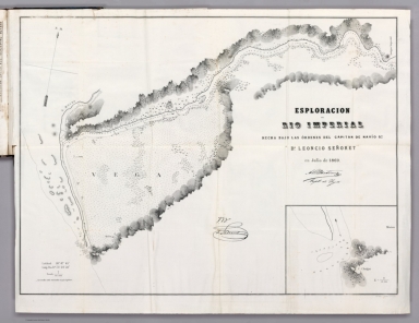
Author
[Gormaz, Francisco Vidal, 1837-1907, Señoret, Leoncio]
Full Title
Esploracion del Rio Imperial hecha bajo las órdenes del capitan de navío go. dn. Leoncio Señoret en Julio de 1869. Lit. Cadot I Brandt, Santiago.
List No
14329.017
Note
Nautical chart of the Río Imperial [Imperial River], Chile, in July, 1869. Shows cities, roads, topography, drainage, shorelines, shoals, islands, soundings and anchorage. Relief illustrated with hachures. Includes coordinate points, a scale statement and a compass rose with north oriented toward top of sheet. Descriptive note beneath title. Text: Las sondas están marcadas en pies ingleses [= Probes are marked in English feet]. With inset chart: [C. Cholgui]. Black and white lithograph. Chart is 46 x 63 cm, on fold-out sheet 51 x 66 cm. In third section of atlas, Reconocimientos de la costa comprendida entre la rada de Los Vilos i el Rio Chopa ...
Author
[Gormaz, Francisco Vidal, 1837-1907, Simpson, Enrique]
Full Title
Esploracion de la costa occidental de la Patagonia. Plano levantado por los Oficiales de la corbeta Chacabuco. al mando del capitan de fragato graduado dn. Enrique Simpson. durante los meses de Marzo in Abril de 1870. Lit. A. Vega ...
List No
14329.020
Note
Nautical chart of the exploration of the Patagonian west coast, Argentina and Chile, in March and April, 1870. Shows cities, roads, topography, vegetation, drainage, shorelines, shoals, islands and soundings. Relief illustrated with hachures. Includes latitudinal and longitudinal lines, a scale statement and a compass rose with north oriented toward top of sheet. Black and white lithograph. With three inset charts: Puerto Laguna -- Puerto Perez -- Puerto Chacabuco. Chart is 34 x 56 cm, on fold-out sheet 44 x 61 cm. In third section of atlas, Reconocimientos de la costa comprendida entre la rada de Los Vilos i el Rio Chopa ...
Author
Elwe, Jan Barend
Full Title
De Golf van Mexico, de eilanden en het omleggende land. Zaamengesteld, en op nieuw gecorrigeerd volgens de beste Waarnemingen. Te Amsterdam, by Jan Barend Elwe, MDCCXCII.
List No
14478.055
Note
Map of the Gulf of Mexico and vicinity. Shows countries, regions, cities, topography, vegetation, bodies of water, drainage, coastlines and islands. Features routes of exploration. Relief shown pictorially. Includes a compass rose with north oriented toward top of sheet, two bar scales, latitudinal and longitudinal lines, and descriptive notes throughout. With a decorative cartouche. Map is 47 x 56 cm, on double sheet 58 x 70 cm.
Author
[Gorshkov, Sergei Georgievich, Soviet Union. Voenno-Morskoĭ Flot]
Full Title
Geograficheskiye otkrytiia Pervye opisi beregov. (to accompany) Atlas okeanov : Severnyy ledovityy Okean. 1980.
List No
13624.013
Note
Map of Arctic region colored in outline on 2 sheets. Showing exploration of the Arctic region. Insets: showing Russian's first coasts and islands geographical discoveries.
Author
[Gorshkov, Sergei Georgievich, Soviet Union. Voenno-Morskoĭ Flot]
Full Title
Vazhneyshie Plavaniia i Ekspeditsii do XVIII veka. (to accompany) Atlas okeanov : Severnyy ledovityy Okean. 1980.
List No
13624.014
Note
Map of Arctic region colored in outline on 2 sheets. Showing major voyages and expeditions until the ХVIIII century by Russian, English Dutch and Norman.
Author
[Gorshkov, Sergei Georgievich, Soviet Union. Voenno-Morskoĭ Flot]
Full Title
Vazhneyshie Plavaniia i okeanograficheskie ekspeditsii ot nachala XVIII veka do serediny XIX veka. (to accompany) Atlas okeanov : Severnyy ledovityy Okean. 1980.
List No
13624.015
Note
Map of Arctic Ocean, colored in outline on 2 sheets. with 2 insets. Showing major Russian's voyages and oceanographic expeditions from the early 18th century to the mid-19th. century.
Author
[Gorshkov, Sergei Georgievich, Soviet Union. Voenno-Morskoĭ Flot]
Full Title
Vazhneyshie Plavaniia i okeanograficheskie ekspeditsii c serediny XIX veka po 1914 god. (to accompany) Atlas okeanov : Severnyy ledovityy Okean. 1980.
List No
13624.016
Note
Map of Arctic Ocean, colored in outline on 2 sheets. with 2 insets. Showing the most important voyages and oceanographic expeditions from the middle of the 19th. century to 1914.
Author
[Gorshkov, Sergei Georgievich, Soviet Union. Voenno-Morskoĭ Flot]
Full Title
Vazhneyshie okeanograficheskie ekspeditsii 1919-1939 gg.. (to accompany) Atlas okeanov : Severnyy ledovityy Okean. 1980.
List No
13624.017
Note
Map of Arctic Ocean, colored in outline on 2 sheets. with inset. Showing the most important voyages and oceanographic expeditions from 1919-1939.
Author
[Gorshkov, Sergei Georgievich, Soviet Union. Voenno-Morskoĭ Flot]
Full Title
Vazhneyshie okeanograficheskie ekspeditsii 1946-1960 gg. (to accompany) Atlas okeanov : Severnyy ledovityy Okean. 1980.
List No
13624.018
Note
Map of Arctic Ocean, colored in outline on 2 sheets. with inset. Showing the most important voyages and oceanographic expeditions from 1946-1960.
Author
[Gorshkov, Sergei Georgievich, Soviet Union. Voenno-Morskoĭ Flot]
Full Title
Issledovaniye Arktiki 1961-1979 gg. (to accompany) Atlas okeanov : Severnyy ledovityy Okean. 1980.
List No
13624.019
Note
Map of Arctic Ocean on 2 sheets. with inset. Showing Arctic exploration 1961-1979.
Author
[Gorshkov, Sergei Georgievich, Soviet Union. Voenno-Morskoĭ Flot]
Full Title
Vozdushnoye osvoyeniye Arktiki. (to accompany) Atlas okeanov : Severnyy ledovityy Okean. 1980.
List No
13624.020
Note
2 maps on 1 sheet, with 2 insets. Showing Aerial exploration of the Arctic.
Author
Herrera y Tordesillas, Antonio de, -1625
Full Title
(Title Page to) Descriptio Indiæ Occidentalis per Antonium de Herrera regium Indiarum et Castellæ historiographum.
List No
14476.005
Note
Title page to Descriptio Indiæ Occidentalis per Antonium de Herrera regium Indiarum et Castellæ historiographum, the first part of Nieuwe werelt anders ghenaempt West-Indien. Title translates to: A description of the West Indies by Antonius de Herrera, the royal historian of the Indies and Castile. Includes an engraved map of the Western Hemisphere, which features the earliest known published image California as an island, a cartographic myth that persisted until the 18th century. Decorated with engraved Castilian coat of arms, and eight vignettes showing Aztec gods and scenes of Nova Hispania [Mexico], including a temple.
Author
Herrera y Tordesillas, Antonio de, -1625
Full Title
Descripcion de las Indias Ocidentalis.
List No
14476.006
Note
Map of the Western Hemisphere, featuring the West Indies. Shows countries, cities, topography, bodies of water, drainage, coastlines and islands. Relief shown pictorially. Includes latitudinal lines and longitudinal lines, as well as a descriptive note. Black and white engraving. Map is 23 x 32 cm, on double sheet 29 x 36 cm. Appears in Descriptio Indiae Occidentalis per Antonium de Herrera regium Indiarum et Castellae historiographum, the first part of Nieuwe werelt anders ghenaempt West-Indien. (Plate number inferred.)
Author
Herrera y Tordesillas, Antonio de, -1625
Full Title
Descripçion de las Indias del Norte.
List No
14476.007
Note
Map of the West Indies. Shows countries, audiencias (royal courts in Spanish colonial America), bodies of water, drainage, coastlines and islands. Includes latitudinal lines and longitudinal lines, as well as descriptive notes. Black and white engraving. Map is 21 x 29 cm, on double sheet 29 x 36 cm. Appears in Descriptio Indiae Occidentalis per Antonium de Herrera regium Indiarum et Castellae historiographum, the first part of Nieuwe werelt anders ghenaempt West-Indien.
Author
Herrera y Tordesillas, Antonio de, -1625
Full Title
Description del destricto del audiencia de la Española.
List No
14476.008
Note
Map of Hispaniola. Shows countries, regions, cities, bodies of water, drainage, coastlines, shoals and islands. Includes latitudinal lines and longitudinal lines. Indexed to indicate city names. Black and white engraving. Map is 21 x 29 cm, on double sheet 29 x 36 cm. Appears in Descriptio Indiae Occidentalis per Antonium de Herrera regium Indiarum et Castellae historiographum, the first part of Nieuwe werelt anders ghenaempt West-Indien.
|