|
Author
Muassasah i Jughrafiay i va Kartugrafi i Sahab
Full Title
Shabakeh toleed, enteghal va tozie nirooye bargh = generation-transmission & distribution system of electricity power. (to accompany) Atlas of Iran : white revolution = Atlas-i Enqelab-e Sefid-e Iran. Sahab G. D. I.
List No
13114.145
Note
Color map of Iran. Shows power stations and transmission lines, etc. Includes legend.
Author
[Arutiunian, Aramais Bagratovich, Bagdasarian, A. B.]
Full Title
Energeticheskiye resursy. (to accompany) Atlas Armi︠a︡nskoĭ Sovetskoĭ Sot︠s︡ialisticheskoĭ Respubliki. Erevan - Moskva 1961.
List No
13361.059
Note
2 color energy resources maps on 1 sheet. Includes legend, and diagrams. Relief shown by contours and spot heights.
Author
[Arutiunian, Aramais Bagratovich, Bagdasarian, A. B.]
Full Title
Elektrostantsii. (to accompany) Atlas Armi︠a︡nskoĭ Sovetskoĭ Sot︠s︡ialisticheskoĭ Respubliki. Erevan - Moskva 1961.
List No
13361.072
Note
Color map. Shows power plants and energy production. Includes 2 inset maps, legend, charts and graphs. Relief shown by shadings and spot heights.
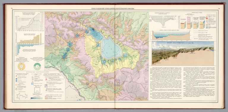
Author
[Arutiunian, Aramais Bagratovich, Bagdasarian, A. B.]
Full Title
Sevan-razdanskiy irrigatsionno-energeticheskiy kompleks. (to accompany) Atlas Armi︠a︡nskoĭ Sovetskoĭ Sot︠s︡ialisticheskoĭ Respubliki. Erevan - Moskva 1961.
List No
13361.078
Note
Color map of Sevan–Hrazdan hydroelectric complex on 2 sheets. Includes profile view of Sevan–Hrazdan Cascade, descriptive text, cross section, legend, charts and graphs. Relief shown by shadings and spot heights.
Author
[Arutiunian, Aramais Bagratovich, Baghdasaryan, Andranik Bakhsii]
Full Title
Energetik rresursner. (to accompany) Neratsakan bazhin. Haykakan Sovetakan Sotsʻialistakan Rhespowblikayi atlas. Erevan – Moskovyan 1961.
List No
13362.059
Note
2 color energy resources maps on 1 sheet. Includes legend, and diagrams. Relief shown by contours and spot heights.
Author
[Arutiunian, Aramais Bagratovich, Baghdasaryan, Andranik Bakhsii]
Full Title
Elektrakayanner. (to accompany) Neratsakan bazhin. Haykakan Sovetakan Sotsʻialistakan Rhespowblikayi atlas. Erevan – Moskovyan 1961.
List No
13362.072
Note
Color map. Shows power plants and energy production. Includes 2 inset maps, legend, charts and graphs. Relief shown by shadings and spot heights.
Author
Libya. Maslahat al-Misahah
Full Title
Electricity = Kahraba'. (to accompany) Atlas al-watani lil-Jamahiriyah al-ʻArabiyah al-Libiyah al-Shabiyah al-Ishtirakiyah = National atlas of the Socialist People's Libyan Arab Jamahiriya.
List No
13405.047
Note
Color map, with 2 insets. Showing electricity production, consumption of electricity and power stations. Includes color coded reference to symbols and charts.
Author
Ohashi, Mitsuyoshi
Full Title
(Electric power). (to accompany) 東京市勢圖表 = Tōkyo Shisei Zuhyo = Graphic Illustration of Tokyo City. 東京市, Tokyo shi, Showa 10 (1935).
List No
13438.042
Note
Map showing electric power transmission lines. Includes legend and descriptive text.
Author
Ohashi, Mitsuyoshi
Full Title
(Electric power). (to accompany) 東京市勢圖表 = Tōkyo Shisei Zuhyo = Graphic Illustration of Tokyo City. 東京市, Tokyo shi, Showa 10 (1935).
List No
13438.043
Note
Map and diagrams, showing production and consumption of electricity. Includes legend and descriptive text.
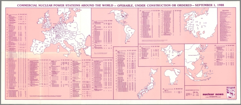
Author
[American Nuclear Society, Nuclear News]
Full Title
Commercial nuclear power stations around the world : operable, under construction or ordered. September 1, 1988. Nuclear News . La Grange Park, Illinois. Copyright by American Nuclear Society.
List No
13514.000
Author
[Glavnoe Upravlenie Navigat︠s︡ii i Okeanografii Ministerstva Oborony SSSR., Soviet Union. Voenno-Morskoĭ Flot.]
Full Title
Turbulentnyi teploobmen mezhdu poverkhnost'iu okeana i atmosferoy. (To accompany) Atlas okeanov : Tikhiy Okean = Atlas of the Oceans : Pacific Ocean. 1974.
List No
13622.052
Note
Map of the Pacific Ocean. Shows turbulent heat transfer between the ocean surface and the atmosphere. Includes chart showing turbulent heat exchange in Kilocalories per cm per year, and Diagrams showing annual variation of turbulent heat transfer between ocean surface and atmosphere in various climatic zones. Prime meridian: Greenwich.
Author
[Glavnoe Upravlenie Navigat︠s︡ii i Okeanografii Ministerstva Oborony SSSR., Soviet Union. Voenno-Morskoĭ Flot.]
Full Title
Teploobmen poverkhnosti okeana s nizhelezhashchimi sloiami. (To accompany) Atlas okeanov : Tikhiy Okean = Atlas of the Oceans : Pacific Ocean. 1974.
List No
13622.053
Note
Map of the Pacific Ocean. Shows Heat exchange of the ocean surface with the underlying layers. Includes chart showing heat exchange from ocean surface to the underlying layers and from underlying layers to the ocean surface. Prime meridian: Greenwich.
Author
[Grigorovich, Alexander S., Sautin, Ivan V., Ivanitsky, Ivan P., Podgornova, Valentina M., Lissitzky, Lazar M.]
Full Title
Mechanizationof labor proceses in industry. (to accompany) USSR. Soiuz Sovetskikh Sotsialisticheskikh Respublik = Union of Soviet Socialist Republics. Scientific Publishing Institute of Pictorial Statistics.
List No
13675.025
Note
Color statistical diagram and graphs, showing consumption of mechanical and electrical energy.
Author
[Grigorovich, Alexander S., Sautin, Ivan V., Ivanitsky, Ivan P., Podgornova, Valentina M., Lissitzky, Lazar M.]
Full Title
Electrification. (to accompany) USSR. Soiuz Sovetskikh Sotsialisticheskikh Respublik = Union of Soviet Socialist Republics. Scientific Publishing Institute of Pictorial Statistics.
List No
13675.029
Note
Color statistical diagram, showing production of electrical energy. Inset vignette showing all the electrical produced in all the stations in 1913 and production in single hydraulic station in 1937.
Author
[Grigorovich, Alexander S., Sautin, Ivan V., Ivanitsky, Ivan P., Podgornova, Valentina M., Lissitzky, Lazar M.]
Full Title
The biggest electrical stations newly constructed by Soviets. (to accompany) USSR. Soiuz Sovetskikh Sotsialisticheskikh Respublik = Union of Soviet Socialist Republics. Scientific Publishing Institute of Pictorial Statistics.
List No
13675.030
Note
Colored map, overlaid with data visualization, showing the power stations, including hydraulic power coal and peat.
Author
[Grigorovich, Alexander S., Sautin, Ivan V., Ivanitsky, Ivan P., Podgornova, Valentina M., Lissitzky, Lazar M.]
Full Title
Coal mining industry. (to accompany) USSR. Soiuz Sovetskikh Sotsialisticheskikh Respublik = Union of Soviet Socialist Republics. Scientific Publishing Institute of Pictorial Statistics.
List No
13675.031
Note
Color statistical diagram, showing output of coal from 1913-1937. Inset map: overlaid with data visualization and accompanied by a legend, showing coal output of basins.
Author
[Grigorovich, Alexander S., Sautin, Ivan V., Ivanitsky, Ivan P., Podgornova, Valentina M., Lissitzky, Lazar M.]
Full Title
Oil industry. (to accompany) USSR. Soiuz Sovetskikh Sotsialisticheskikh Respublik = Union of Soviet Socialist Republics. Scientific Publishing Institute of Pictorial Statistics.
List No
13675.032
Note
Color statistical diagrams, showing the extraction and production of petroleum refineries in 1913 and 1937. Inset map: overlaid with data visualization and accompanied by a legend, showing production of petroleum in various regions.
Author
[Grigorovich, Alexander S., Sautin, Ivan V., Ivanitsky, Ivan P., Podgornova, Valentina M., Lissitzky, Lazar M.]
Full Title
Iron and steel industry. (to accompany) USSR. Soiuz Sovetskikh Sotsialisticheskikh Respublik = Union of Soviet Socialist Republics. Scientific Publishing Institute of Pictorial Statistics.
List No
13675.033
Note
Color statistical diagrams, showing the production of rolled iron from 1913 to 1937. Inset map: overlaid with data visualization, showing coal output of basins.
Author
[Berezin, A.D., 9]
Full Title
Elektrifikatsiia SSSR. 2. Promyshlennost'. (to accompany) Sotsialisticheskoe Stroitel'stvo Soyuza Sovetskikh Sotsialisticheskikh Respublik.
List No
13676.038
Note
Statistical pictograms on 2 sheets, showing electrification of the USSR. Includes text and legend.
Author
[Berezin, A.D., 9]
Full Title
Elektrifikatsiia SSSR set' i moshchnost' v tys. kvt. elektrostantsiy, po rayonam evropeyskoy chasti SSSR. 2. Promyshlennost'. (to accompany) Sotsialisticheskoe Stroitel'stvo Soyuza Sovetskikh Sotsialisticheskikh Respublik.
List No
13676.039
Note
Color map of European part of the USSR, with illustration. Showing power plants and the electrification network. Includes text and legend.
Author
[Berezin, A.D., 9]
Full Title
Kamennougol'naia promyshlennost'. 2. Promyshlennost'. (to accompany) Sotsialisticheskoe Stroitel'stvo Soyuza Sovetskikh Sotsialisticheskikh Respublik.
List No
13676.040
Note
Statistical diagram, showing coal industry, 1913-1935.
Author
[Berezin, A.D., 9]
Full Title
Dobycha uglya po basseynam v 1935 g. v sravnenii s 1913 g. 2. Promyshlennost'. (to accompany) Sotsialisticheskoe Stroitel'stvo Soyuza Sovetskikh Sotsialisticheskikh Respublik.
List No
13676.041
Note
Map of the Soviet Union on 2 sheets, showing coal mining basins in 1935 versus 1913.
Author
[Berezin, A.D., 9]
Full Title
Udel'nyy ves mekhanizirovannoy dobychi kamennogo uglya. 2. Promyshlennost'. (to accompany) Sotsialisticheskoe Stroitel'stvo Soyuza Sovetskikh Sotsialisticheskikh Respublik.
List No
13676.042
Note
Comparative statistical pictograms and illustrations, showing mechanized and non mechanized coal mining production, 1932-1936.
Author
[Berezin, A.D., 9]
Full Title
Tekhnicheskoe vooruzhenie kamennougol'noy promyshlennosti. 2. Promyshlennost'. (to accompany) Sotsialisticheskoe Stroitel'stvo Soyuza Sovetskikh Sotsialisticheskikh Respublik.
List No
13676.043
Note
Statistical pictograms, showing technical equipment of the coal industry. Includes legend.
Author
[Berezin, A.D., 9]
Full Title
(Text Page to) Initsiatory Stakhnovskogo dvizheniia v ugol'noy pro myshlennosti ... 2. Promyshlennost'. (to accompany) Sotsialisticheskoe Stroitel'stvo Soyuza Sovetskikh Sotsialisticheskikh Respublik.
List No
13676.044
Note
text with 8 portrait of the initiators of the Stakhanovithe movement in coal industry.
Author
[Berezin, A.D., 9]
Full Title
Organizatsiya i proizvoditel'nost' truda pri Stakhanovskoy rabote. 2. Promyshlennost'. (to accompany) Sotsialisticheskoe Stroitel'stvo Soyuza Sovetskikh Sotsialisticheskikh Respublik.
List No
13676.045
Note
Statistical pictograms, with views, showing organization and productivity of labor in Stakhanovithe movement.
Author
[Berezin, A.D., 9]
Full Title
Dobycha torfa i slantsev. 2. Promyshlennost'. (to accompany) Sotsialisticheskoe Stroitel'stvo Soyuza Sovetskikh Sotsialisticheskikh Respublik.
List No
13676.049
Note
Statistical diagrams, with view. Showing growth of extraction of peat mining and oil shale, 1913-1936.
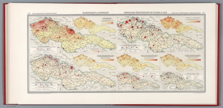
Author
[Pantoflíček, Jaroslav, Česká akademie věd a umění.]
Full Title
Elektrarny à plynarny = Centrales électriques et usines a gaz. Jos. Mraz. 40. Atlas Republiky Československé = Atlas de la Republique Tchecoslovaque. Vydala Ceska akademie ved a umeni -1934- Editeur Nakladatelstvi Orbis, Praha : Tiskne Vojenskyì zeměpisnyì uìstav.
List No
13678.046
Note
7 maps of Czech Republic, with 3 insets on 2 sheets. Showing power plants and gas stations. Includes color coded reference.
Author
Miṣr. al-Jihāz al-Markazī lil-Taʻbiʼah al-ʻĀmmah wa-al-Iḥṣāʼ,
Full Title
الطاقة الكهربائية ببعض دول العالم عام ١٩٦٤ = al-ṭāqah al-kahrabāʼīyah bibaed duwal al'alam aam 1964. aam 1964. (to accompany) الأطلس الإحصائي الجمهورية العربية المتحدة = al-Aṭlas al-iḥṣāʼ al-Jumhūrīyah al-ʻArabīyah al-Muttaḥidah. July 23, 1967.
List No
13681.067
Note
Statistical diagrams, presenting electrical energy in some of the countries in the world in 1964 and development of electrical energy in Egypt.
Author
[Hickmann, Anton Leo, 1834-1906, Fischer, Alois, b. 1894]
Full Title
Erzeugung von elektrischer Energie 1924. G. Freytag & Berndt A.G., Wien. (to accompany) Prof. Hickmann's Geographisch-statistischer universal-atlas, 1927.
List No
13687.058
Note
Statistical tables. Showing electrical energy generation in billion kWh. Fully electric railways in some major countries.
Author
Neurath, Otto, 1882-1945
Full Title
Die Energieveersorgung der Erde. Angefertigt für das Bibliographische Institut AG., Leipzig. Gesellschafts- und Wirtschaftsmuseum in Wien. ©
List No
14080.053
Note
Colored map showing the energy supply across the world. Includes a legend. Map is 21 x 40, on sheet 31 x 46 cm. Information depicted with Isotype (International system of typographic picture education), a method for assembling, configuring and disseminating information and statistics through pictorial means, invented by Otto and Marie Neurath.
Author
[Budapest (Hungary). Föváros Statisztikai Hivatal, Illyefalvi, Lajos I., 1881-1944]
Full Title
Gázellátás. = Gasversorgung. : A gáztermelés és fogyasztás alakulása. = Gestaltung der Gasproduktion und des Gasverbrauches. : a) Általában. = Im allgemeinen. 1856-1931. -- b) A fogyasztók (gázmérök) száma. = Anzahl der Verbraucher (Gasmesser). 1901-1931. -- c) A fejenkinti gázfogyasztás alakulása. = Gestaltung des Gasverbrauches pro Kopf. -- -- A gázfogyasztás megoszlása fogyasztók szerint. = Verteilung des Gasverbrauches nach den Verbrauchern. 1913-1931. : 1913 -- 1921 -- 1931. -- -- Szénfelhasználás és koksztermelés. = Kohlenverbrauch und Koksproduktion. 1911-1931. -- -- A föcsöhálózat hosszának fejlödése. = Entwicklung der Länge des Hauptröhrennetzes. 1874-1931. -- -- A gázmüvek pénzügyi eredményei. = Finanzergebnisse der Gaswerke. 1913-1931. -- -- A gáz egységárának alakulása. = Gestaltung des Gaseinheitspreises. 1858-1931.
List No
14245.121
Note
Ten colored diagrams representing the gas supply in Budapest, over time. First diagram shows gas production and consumption (in general), from 1856 to 1931; second shows the number of gas consumers, from 1901 to 1931; third shows gas consumption per capita, from 1869 to 1930; fourth shows the distribution of gas consumption according to consumers, in 1913; fifth shows the distribution of gas consumption according to consumers, in 1921; sixth shows the distribution of gas consumption according to consumers, in 1931; seventh shows coal consumption and coke production, from 1911 to 1931; eighth shows the development - in length - of the main tube network, from 1874 to 1931; ninth shows the finances of the gas works, from 1913 to 1931; and tenth shows gas unit prices, from 1858 to 1931. Diagrams include legends. Together, diagrams are 23 x 30 cm, on sheet 26 x 35 cm.
Author
[Budapest (Hungary). Föváros Statisztikai Hivatal, Illyefalvi, Lajos I., 1881-1944]
Full Title
Gázvezetékkel ellátott terület. = Mit Gasleitung Versehene Gebiete. 1932.
List No
14245.122
Note
Colored map representing areas provided with gas pipes within Budapest, in 1932. Includes an explanation. In both Hungarian and German. Map is 23 x 30 cm, on sheet 26 x 35 cm.
Author
[Budapest (Hungary). Föváros Statisztikai Hivatal, Illyefalvi, Lajos I., 1881-1944]
Full Title
A gázchöhálózat fejlödése. = Entwicklung des Gasröhrennetzes. 1910-1932.
List No
14245.123
Note
Colored map representing the development of the gas pipe network within Budapest, from 1910 to 1932. Includes a legend and an explanation. In both Hungarian and German. Map is 23 x 30 cm, on sheet 26 x 35 cm.
Author
[Budapest (Hungary). Föváros Statisztikai Hivatal, Illyefalvi, Lajos I., 1881-1944]
Full Title
Villamos áramellátás. = Elektrische Stromversorgung. : Az áramtermelés és fogyasztás alakulása. = Gestaltung der Stromerzeugung und des Stromverbrauches. 1918-1932. -- -- Az áramfogyasztás részletezése. = Spezifikation des Stromverbrauches. 1920-1932. : 1920 -- 1932. -- -- A fogyasztók számának alakulása. = Gestaltung der Anzahl der Verbraucher. 1894-1932. -- -- A fejenkinti áramfogyasztás. = Stromverbrauch pro Kopf. 1920-1932. -- -- A bekapcsolt terhelés. = Eingeschalterte Belastung. 1918-1932. -- -- Bekapcsolt mótorok száma. = Anzahl der Eingeschalteten Motoren. 1926-1932. -- -- A kábel- és légvezetékhálózat fejlödése. = Entwicklung des Kabel- und Luftleitungsnetzes. 1918-1932. -- -- Az árambevétel alakulása. = Gestaltung der Einnahmen für Strom. 1918-1932. -- -- A villamos áram egységárának alakulása. = Gestaltung des Einheitspreises des Elektrischen Stromes. 1914-1932.
List No
14245.124
Note
Ten colored diagrams representing the electrical power supply in Budapest, over time. First diagram shows electricity generation and consumption, from 1918 to 1932; second shows the specification of power consumption, in 1920; third shows the specification of power consumption, in 1932; fourth shows the number of consumers, from 1894 to 1932; fifth shows power consumption per capita, from 1920 to 1932; sixth shows the activated load, from 1918 to 1932; seventh shows the number of motors switched on, from 1926 to 1932; eighth shows the development of the cable and air line network, from 1918 to 1932; ninth shows the income for electricity, from 1918 to 1932; and tenth shows the unit price of electric current, from 1914 to 1932. Diagrams include legends. Together, diagrams are 23 x 30 cm, on sheet 26 x 35 cm.
Author
[Budapest (Hungary). Föváros Statisztikai Hivatal, Illyefalvi, Lajos I., 1881-1944]
Full Title
Villamos áramszolgáltatással ellátott terület. = Mit Elektrischem Strom Versehene Gebiete. 1932. -- -- A termelt áram mennyiségének megoszlása áramfejlestötel szerint. = Verteilung der erzeugten Stommenge nach Elektrizitätsanlagen. : 1914 -- 1918 -- 1932.
List No
14245.125
Note
Colored map representing areas provided with electricity within Budapest, in over time. Includes a legend and an explanation. With three diagrams representing the amount of electricity generated by electricity systems in 1914, 1918 and 1932. Also includes a legend pertaining to the diagrams. In both Hungarian and German. Together, map and diagrams are 23 x 30 cm, on sheet 26 x 35 cm.
Author
[Budapest (Hungary). Föváros Statisztikai Hivatal, Illyefalvi, Lajos I., 1881-1944]
Full Title
A fütö- és világítóanyagok felhozatalának megoszlása vármegyék szerint.¹) = Verteilung der Zufuhr von Heiz- und Leuchtmaterialien nach Komitaten.¹)
List No
14246.103
Note
Colored map, overlaid with data visualization, representing the distribution of the domestic supply of heating and lighting materials within counties in Hungary, in 1933. Includes a legend, as well as explanatory text. In both Hungarian and German. Map is 23 x 30 cm, on sheet 26 x 35 cm.
Author
[Budapest (Hungary). Föváros Statisztikai Hivatal, Illyefalvi, Lajos I., 1881-1944]
Full Title
Tüzifa. = Brennholz ...
List No
14246.104
Note
Colored map, overlaid with data visualization and accompanied by nine diagrams, representing the domestic supply of firewood within counties in Hungary, from 1926 to 1934. Includes legends, as well as explanatory text. In both Hungarian and German. Together, map and diagrams are 23 x 30 cm, on sheet 26 x 35 cm.
Author
[Budapest (Hungary). Föváros Statisztikai Hivatal, Illyefalvi, Lajos I., 1881-1944]
Full Title
Belföldi szén. = Inländische Kohle ...
List No
14246.105
Note
Colored map, overlaid with data visualization and accompanied by nine diagrams, representing the domestic supply of coal within counties in Hungary, from 1926 to 1934. Includes legends, as well as explanatory text. In both Hungarian and German. Together, map and diagrams are 23 x 30 cm, on sheet 26 x 35 cm.
Author
[Budapest (Hungary). Föváros Statisztikai Hivatal, Illyefalvi, Lajos I., 1881-1944]
Full Title
Faszén. = Holzkohle ...
List No
14246.106
Note
Colored map, overlaid with data visualization and accompanied by nine diagrams, representing the domestic supply of charcoal within counties in Hungary, from 1926 to 1934. Includes legends, as well as explanatory text. In both Hungarian and German. Together, map and diagrams are 23 x 30 cm, on sheet 26 x 35 cm.
Author
[Budapest (Hungary). Föváros Statisztikai Hivatal, Illyefalvi, Lajos I., 1881-1944]
Full Title
Ásványolajok. = Mineralöle ...
List No
14246.107
Note
Colored map, overlaid with data visualization and accompanied by nine diagrams, representing the domestic supply of mineral oils within counties in Hungary, from 1926 to 1934. Includes legends, as well as explanatory text. In both Hungarian and German. Together, map and diagrams are 23 x 30 cm, on sheet 26 x 35 cm.
Author
[Budapest (Hungary). Föváros Statisztikai Hivatal, Illyefalvi, Lajos I., 1881-1944]
Full Title
Gyáripari telepek: II/b. Közhasználatú villamos áramfejlesztötelepek. = Fabrikindustrieanlagen: II/b. Gemeinnützige Elektrizitätsanlagen ...
List No
14247.088
Note
Colored map, overlaid with data visualization and accompanied by seven diagrams, representing factory sites of public power generating plants in Budapest and greater Hungary, from 1921 to 1936. Third in a series of twelve plates of maps and diagrams on industry (73-84). Includes legends, as well as explanatory text. In both Hungarian and German. Together, map and diagrams are 23 x 30 cm, on sheet 26 x 35 cm.
Author
[Imhof, Eduard, 1895-1986, Eidgenössische Landestopographie, Wüger, Hans]
Full Title
Energiewirtschaft : Elektrizität = Economie énergétique : électricité. Bearbeitung ... : Hans Wüger. Kartographische Gestaltung: Redaktion Atlas der Schweiz, Eidgenössischen Technische Hochschule, Zürich ... © Atlas der Schweiz. Eidg. Landestopographie, Wabern-Bern, 1972 ...
List No
14256.223
Note
Colored energy map of Switzerland, numbered 59 within Atlas der Schweiz. On second and third pages of fifty-ninth (numbered) folio. Title - in German and French - translates to: [Energy industry : Electricity]. Map shows the international border, topography, lakes, drainage, and the sites of electricity manufacturing. Relief shown with shading. Includes legends, explanatory notes and a scale statement. Map is 45 x 70 cm, on sheet 52 x 76 cm. "59" in upper left and right corners. One related map and one chart follow on subsequent page. Accompanied by descriptive text on first page of folio.
Author
[Imhof, Eduard, 1895-1986, Eidgenössische Landestopographie, Wüger, Hans]
Full Title
Energiewirtschaft = Economie énergétique = Economia dell'energia : Gas und Öl = Gaz et pétrole -- Bedarf an Rohenergie in der Schweiz = Besoins d'énergie brute en Suisse = Fabbisogno d'energia greggia in Svizzera. Bearbeiter ... : Dr. phil. Hans Bührer, Rüschlikon, Dipl. Ing. Hans Wüger, Kilchberg-ZH.
List No
14256.224
Note
Colored energy map and chart of Switzerland, numbered 59 within Atlas der Schweiz. On fourth page - back cover - of fifty-ninth (numbered) folio. Titles - in German, French and Italian - translate to: [Energy industry : Gas and oil -- Demand for raw energy in Switzerland]. Map shows the international border, topography, lakes, drainage, and the sites of gas and oil extraction; chart shows the demand for raw energy, over time. Relief shown with shading. Includes legends, explanatory notes and a scale statement. Together, map and diagram are 45 x 33 cm, on sheet 52 x 38 cm. With bibliographic citations at bottom of sheet. "59" in upper left corner. One related map on second and third pages of folio. Accompanied by descriptive text on first page.
Author
[Geological Survey (U.S.), United States. Federal Power Commission]
Full Title
Oil, gas and coal consumption, 1960-1964 average / compiled by U. S. Geologic Survey, 1966 -- Hydroelectric potential, developed and undeveloped : 1966 / compiled from information provided by Federal Power Commission, 1967.
List No
14359.138
Note
Two mineral maps representing the United States, featuring the geographic locations of oil, gas and coal consumption, as well as hydroelectric power potential (both developed and undeveloped), as of 1966. Maps also show political boundaries, bodies of water, coastlines and islands. Maps include legends, as well as bar scales and scale statements. Presented with Albers Equal Area Projection. With two inset maps within each map: Principal islands of Hawaii -- Alaska. Colored lithograph. Maps are each 20 x 31 cm, on sheet 49 x 35 cm. Accompanying descriptive text on page 177. Maps appear in Special subject maps section, subsection Economic : Mineral and energy resources.
Author
[Geological Survey (U.S.), United States. Federal Power Commission, U.S. Atomic Energy Commission]
Full Title
Power generation and transmission : 1968 / adapted from Federal Power Commission, Principal electric facilities in the United States: 1966, M-78, Washington, 1966, map 1:3,484,300 and information provided by Atomic Energy Commission and Federal Power Commission.
List No
14359.140
Note
Mineral map representing the United States, featuring the geographic locations of power generation and transmission, as of 1968. Shows power sources such as hydroelectricity, fossil fuels and nuclear, as well as political boundaries, bodies of water, drainage, coastlines and islands. Includes a legend, as well as a bar scale and scale statement. Presented with Albers Equal Area Projection. With three inset maps: New York City area -- Principal islands of Hawaii -- Alaska. Also, with inset chart: Electric energy production, by power sources. Colored lithograph. Map is 43 x 66 cm, on double sheet 49 x 71 cm. Accompanying descriptive text on page 177. Appears in Special subject maps section, subsection Economic : Mineral and energy resources.
Author
[Geological Survey (U.S.), American Petroleum Institute]
Full Title
Crude oil and products pipelines : 1966 / adapted from 1:1,500,000-scale maps, Crude Oil Pipeline Map of the United States and Southern Canada, and Products Pipeline Map of the United States and Southern Canada, by the American Petroleum Institute, 1967.
List No
14359.176
Note
Transportation map representing the United States, featuring the geographic locations of oil refineries and pipelines for crude oil and related products, as of 1966. Map also shows political boundaries, topography, bodies of water, drainage, coastlines and islands. Relief shown with shading. Includes a legend, as well as a bar scale and scale statement. Presented with Albers Equal Area Projection. With four inset maps: Crude oil flow : 1966 -- Products pipelines flow : 1966 -- Principal islands of Hawaii -- Alaska. Colored lithograph. Map is 43 x 66 cm, on double sheet 49 x 71 cm. Appears in Special subject maps section, subsection Economic : Transportation.
Author
[Geological Survey (U.S.), United States. Federal Power Commission, United States. Bureau of Mines]
Full Title
Natural gas pipelines : 1967 / adapted from a Federal Power Commission map, Principal Natural Gas Pipelines in the United States, 1960, M-57, scale 1:3,801,600; revised by the U. S. Geological Survey, 1967.
List No
14359.177
Note
Transportation map representing the United States, featuring the geographic locations of natural gas fields and pipelines, as of 1967. Map also shows political boundaries, topography, bodies of water, drainage, coastlines and islands. Relief shown with shading. Includes a legend, as well as a bar scale and scale statement. Presented with Albers Equal Area Projection. With three inset maps: Natural gas flow : 1965 ; compiled from U. S. Bureau of Mines Minerals Year Book, 1965, v. II, table 9 -- Principal islands of Hawaii -- Alaska. Colored lithograph. Map is 43 x 66 cm, on double sheet 49 x 71 cm. Appears in Special subject maps section, subsection Economic : Transportation.
Author
[Association universitaire de recherches cartographiques et géographiques, France. Délégation à l'aménagement du territoire et à l'action régionale, Association universitaire de recherches et d'études géographiques]
Full Title
Consommation d'électricité en 1965 -- Consommation d'électricité par habitant, 1965 -- Principaux consommateurs d'électricité, 1961 -- Consommation de gaz en 1965 -- Équipement en gaz des logements, 1962. A.U.R.E.G.
List No
14397.041
Note
Seven maps of energy consumption in the Région Parisienne [Île-de-France], or the Paris Region, France, from 1962 to 1965. Maps show total electricity consumption in 1965, electricity consumption per inhabitant in 1965, the main consumers of electricity in 1961, gas consumption in 1965, and gas equipment in dwellings. Maps include legends and bar scales (scales differ). Colored lithograph. Together, maps are 51 x 64 cm, on sheet 56 x 69 cm. "Transports et énergie 52-1".
Author
[Association universitaire de recherches cartographiques et géographiques, France. Délégation à l'aménagement du territoire et à l'action régionale, Association universitaire de recherches et d'études géographiques]
Full Title
Approvisionnement en énergie et en eau : Charbon et produits pétroliers, 1965 -- Gaz, 1965 -- Électricité, 1965 -- Eau, 1966 -- Approvisionnement en produits alimentaires : Beurre - œufs - fromage - volaille - gibier - poisson -- Légumes : Artichauts - choux fleurs - pommes de terre -- Tomates - salades -- Fruits : Pêches - poires - pommes -- Viande, 1965 : Approvisionnement des marchés de la villette et de vaugirard -- Approvisionnement des pavillons des halles de Paris -- Lait : 12 avril au 5 mai 1963 -- Vin : Campagne 1964-1965. A.U.R.E.G.
List No
14397.090
Note
Eleven maps of the energy, water and food supplies in France, including within the Région Parisienne [Île-de-France], or the Paris Region, from 1963 to 1966. Maps show coal and petroleum products in France, as well as gas, electricity and water in the Paris Region in 1966. Maps also show the food supply in France, including butter, eggs, cheese, vegetables, salad greens, fruits, meats, milk and wine, as well as the suppliers of markets and restaurants of Paris, from 1963 to 1965. Maps include legends and bar scales (scales differ). Colored lithograph. Together, maps are 64 x 51 cm, on sheet 69 x 56 cm. "Rôle national et international de Paris 91-3".
|