|
Author
The Century Press
Full Title
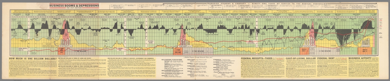
Busines Booms & Depressions The 1947 Edition.
List No
15073.000
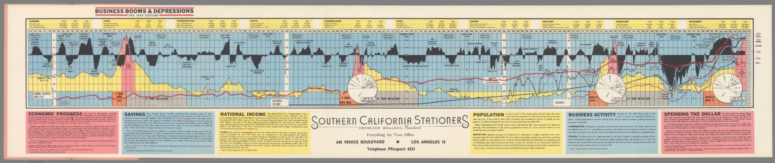
Author
The Century Press
Full Title
Busines Booms & Depressions The 1949 Edition.
List No
15074.002
Author
Anonymous
Full Title
Arpanet Logical Map, March 1977
List No
10442.000
Author
United Communication
Full Title
Herb and Ailment Cross Reference Chart.
List No
15222.000
Note
2nd edition.
Author
Jazwinski, Antoni
Full Title
Tableau Muet Servant aux Exercises Chronologiques et autres de la Methode Dite Polonaise Inventee par A. Jazwinski.
List No
10588.000
Note
Sign by the inventor of this memory system, Antoni Jazwinski. This system of teaching student memorization of large amounts of information was called the Polish system and it was popular in Europe and the United States in the mid 19th century. The system uses the grind of squares and colors to represent dates and character of events over time.
Author
Noichl, Maximilian
Full Title
The Structure of Recent Philosophy from the 1950s to this day. Visualized by Maximilian Noichl. Noichl, 4/5'19.
List No
13519.000
Author
Andrews, RJ
Full Title
(Text page to) Cross-Sections Through California. Elevation and land cover data illustrated across 17 profiles and charts showing Valuable Crops, Sources of Electricity, Population Growth, In an Isotype Style. Copyright RJ Andrews 2020. All rights reserved.
List No
10537.002
Author
Andrews, RJ
Full Title
Cross-Sections Through California. 14x vertical exaggeration USGS elevations with symbols showing MLRC National Land Cover Database (2016) in an Isotype style. Copyright RJ Andrews 2020. All rights reserved.
List No
10537.003
Author
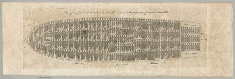
Carey, Mathew
Full Title
Plan of an African Ship's Lower Deck, with Negroes in the Proportion of Not Quite One to a Ton. (May, 1789 issue of the Philadelphia magazine the American Museum)
List No
15180.000
Author
Maury, Matthew Fontaine, 1806-1873
Full Title
Storm and Rain Chart of the North Pacific, Sheet 1 by M.F. Maury, L.L.D. Commander U.S. Navy. Superin'd't of U.S.N. . .
List No
15120.000
Author
Boys' Life
Full Title
Map Symbols. Boys' Life Program Aid Reprint.
List No
15124.000
Note
Date estimated.
Author
Schilling, Felton Dubose
Full Title
Three Centuries Of Great Music
List No
15127.000
Author
[Smith, Elmer, Wolfson, W.M.]
Full Title
Standard Oil (N.J.): An Expanding Universe.
List No
15247.000
Note
Date estimated.
Author
Horn, R.E.
Full Title
Can Computers Think? - The History and Status of the Debate...,
List No
15268.001
Author
Harris & Mills
Full Title
A Chart Of 187 Mechanical Movements, With Description Of Each.
List No
15290.002
Note
Date estimated.
Author
Maury, Matthew Fontaine, 1806-1873
Full Title
Monsoon and Trade Wind Chart of the Indian Ocean.
List No
15547.000
Author
Kahn, Fritz
Full Title
(Text page to) Der Mensch Als Industriepalast (Man As Industrial Palace)
List No
15817.002
Note
This is a separate second issue of Kahn's poster diagram on the workings of the human body, including a reproduction of the 8 text pages that explain it, taken from the five volume work. This poster was also folded and included in the back pocket of volume five, the final volume of Kahn's "Das Leben des Menschen," a pioneering work on the human body as interpreted through info graphics - the body as a machine. The book illustrates the body's different functions through images of technical processes.
Author
Kahn, Fritz
Full Title
Der Mensch Als Industriepalast (Man As Industrial Palace)
List No
15817.001
Note
This is a separate second issue of Kahn's poster diagram on the workings of the human body, including a reproduction of the 8 text pages that explain it, taken from the five volume work. This poster was also folded and included in the back pocket of volume five, the final volume of Kahn's "Das Leben des Menschen," a pioneering work on the human body as interpreted through info graphics - the body as a machine. The book illustrates the body's different functions through images of technical processes.
Author
Priestley, Joseph (1733–1804)
Full Title
A Specimen of a Chart of Biography.
List No
15812.005
Note
A copy of the 1807 edition of the Description is attached. For the full test of the description see https://www.google.com/books/edition/A_Description_of_a_Chart_of_Biography_A/RB7m5jHPeTYC?hl=en&gbpv=1&pg=PA1&printsec=frontcover
Author
K.K. ÖSTERREICHISCHE STAATSBAHNEN [IMPERIAL & ROYAL AUSTRIAN RAILWAYS]
Full Title
K.k. Österreichische Staatsbahnen. K.k. Nordwestbahndirektion. / Linien: Nordwestbahnhof – Tetschen Nordwestbahnhof - (Mittelgrund), Iglau Nordwestbahnhof – Iglau Stadtbahnhof, Schreckenstein – Aussig Templitzerbahnhof.
List No
15644.000
Author
Roth, Chrétien Frédéric Guillaume
Full Title
Essai d’une Distribution généalogique des sciences et des arts principaux.
List No
15811.000
Author
Priestley, Joseph (1733–1804)
Full Title
A Chart of Biography
List No
15812.001
Note
A copy of the 1807 edition of the Description is attached. For the full test of the description see https://www.google.com/books/edition/A_Description_of_a_Chart_of_Biography_A/RB7m5jHPeTYC?hl=en&gbpv=1&pg=PA1&printsec=frontcover
Author
[Hoefler, Don, Yelverton, Jack]
Full Title
Silicon Valley Genealogy. Complementary Copy Silicon/West 1983. SEMI.
List No
15791.000
Author
[Dingle, Edwin J., Institute Of Mentalphysics]
Full Title
Guide To Correct Diet, Health, Happiness And Beauty
List No
15360.000
Author
[Caverly, D.P., W.M. Welch Scientific Company]
Full Title
The Radiant Energy Spectrum. Logarithmic Scale.
List No
15532.000
Note
From: "Primer of Electronics and Radiant Energy" by D.P. Caverly, Sylvania Electric Products Inc. McGraw-Hill Book Company, Inc. Copyright 1952.
Author
[Cacy, Michael, Linch, Gaye]
Full Title
Portland Area High Technology Evolution
List No
15330.000
Author
Desjardins, Constant
Full Title
Vergleichende Darstellung der Grösse, absolute und relative Bevölkerung aller Staaten der Erde, nebst den bekannten Flaggen und Cocarden, zusammengestellt nach Cannabich, Hassel, Balbi &&. Vienna: H. F. Müller, 1835
List No
15809.000
Author
Priestley, Joseph (1733–1804)
Full Title
A Continuation of the Chart according to the Hebrew Chronology...
List No
15812.006
Note
A copy of the 1807 edition of the Description is attached. For the full test of the description see https://www.google.com/books/edition/A_Description_of_a_Chart_of_Biography_A/RB7m5jHPeTYC?hl=en&gbpv=1&pg=PA1&printsec=frontcover
Author
Observatoire Central de l'Indochine
Full Title
Carte servant à suivre la marche des typhons ou dépressions signales par l'Observatoire de Phu-Liên.
List No
15706.000
Note
Date estimated.
Author
[Tokyo Metropolitan Bureau of Transportation, Aoki, Kazuo]
Full Title
(Toei shinjyuku daily diamond line train. Tokyo Metropolitan Transportation Authority. Kazuo Aoki. No. 9.) Showa 62-kagetsu 12-nichi 21 (12.21.1984). No. 10. Showa 62-kagetsu 12-nichi 20 (12.20.1984).
List No
11943.002
Note
Daily chart of Tokyo railway and subway system, on sheet 25x239, folded and pasted into hard covers 26x13. with title on covers. Includes daily schedule for rapid and regular trains and key to symbols.
Author
[Tokyo Metropolitan Bureau of Transportation, Aoki, Kazuo]
Full Title
(Toei shinjyuku daily diamond line train. Tokyo Metropolitan Transportation Authority. Kazuo Aoki. No. 9.) Showa 62-kagetsu 12-nichi 21 (12.21.1984). No. 10. Showa 62-kagetsu 12-nichi 20 (12.20.1984).
List No
11943.003
Note
Daily chart of Tokyo railway and subway system, on sheet 25x239, folded and pasted into hard covers 26x13. with title on covers. Includes daily schedule for rapid and regular trains and key to symbols.
Author
[Hoefler, Don, Yelverton, Jack]
Full Title
Silicon Valley Genealogy,
List No
15410.000
Author
Philips
Full Title
Voice Frequency and carrier frequency transmission technology for cables, Philips
List No
15938.000
Note
Date estimated.
Author
Diboll, Collins C.
Full Title
The HOW, WHEN and WHERE of Discriminating and Enjoyable Drinking
List No
15792.001
Author
USCOMM-ESSA-DC
Full Title
New York Metroplex (Part of FAA Air Traffic Control System - April, 1970)
List No
15901.001
Author
Spencer, Donald D.
Full Title
Computers And Information Processing
List No
15939.000
Note
Date estimated.
Author
Nelson Doubleday
Full Title
Satellites and Space Probes
List No
15174.000
Author
[Katz, Joel, Pulsa]
Full Title
Pulsa. An all-weather demonstration lasting twenty consecutive days will be installed in the Boston Public Garden by Pulsa, researchers in programmed environments. 8-27 October, sunset to ten.
List No
15879.000
Note
Poster for Boston Public Garden Environment by Pulsa October 8-27, 1968.
Author
Peabody, Elizabeth Palmer
Full Title
Christian Era
List No
15895.000
Author
The Century Press
Full Title
(Covers to) Busines Booms & Depressions The 1949 Edition.
List No
15074.001
Author
[Geological Survey (U.S.), United States. Naval Oceanographic Office]
Full Title
Tides : Types and ranges / compiled from information provided by U. S. Naval Oceanographic Office, 1968 -- Representative tide curves.
List No
14359.059
Note
Physical map representing the United States, featuring tides, as of 1968. Shows tide types and ranges, political boundaries, bodies of water, drainage, coastlines and islands. Includes a legend, latitudinal and longitudinal lines, as well as a bar scale and scale statement. With two inset maps: Principal islands of Hawaii -- Alaska. Presented with Albers Equal Area Projection. Also with a set of twelve diagrams showing tide curves. Diagrams feature different areas - such as Kodiak and Key West - as well as different types of tides, including mixed and diurnal. Colored lithograph. Map and diagrams are each 20 x 31 cm, on sheet 49 x 35 cm. Accompanying descriptive text on page 80. Appears in Special subject maps section, subsection Physical : Marine features.
Author
Geological Survey (U.S.)
Full Title
Catastrophic floods since 1900 / compiled by U. S. Geological Survey, 1965 -- Flood potential : The mean annual flood / compiled by U. S. Geological Survey, 1965 -- Flood potential : The ten-year flood / compiled by U. S. Geological Survey, 1965 -- Areas vulnerable to drought / compiled by U. S. Geological Survey, 1965.
List No
14359.087
Note
Four physical maps representing the United States, featuring floods and drought. Maps also show political boundaries, bodies of water, drainage, coastlines and islands, as of 1965. Maps include legends, as well as bar scales and scale statements (scales differ). Presented with Albers Equal Area Projection. Colored lithograph. With two inset maps within each map: Principal islands of Hawaii -- Alaska. Also with a set of nine diagrams showing long-term trends in runoff. Colored lithograph. Together, maps and diagrams are 42 x 31 cm, on sheet 49 x 35 cm. Accompanied by descriptive text, with additional text appearing on page 117. Maps appear in Special subject maps section, subsection Physical : Water.
Author
Geological Survey (U.S.)
Full Title
Prevalent concentration of dissolved minerals in surface water / adapted from U. S. Geological Survey, Prevalent dissolved-solids concentration of rivers, HA-61, Washington, USGS, 1962, pl. 1, map 1:7,000,000, conterminous U. S. -- Concentration of dissolved minerals in ground water / adapted from U. S. Geological Survey, Depth to and quality of shallowest ground water containing more than 1,000 parts per million of dissolved, HA-199, Washington, USGS, 1965, sheet 1, map 1:3,168,000, conterminous U. S.
List No
14359.089
Note
Two physical maps representing the United States, featuring dissolved minerals in both surface and ground water, as of 1965. Maps also show political boundaries, bodies of water, drainage, coastlines and islands. Maps include legends, as well as bar scales and scale statements. Presented with Albers Equal Area Projection. Colored lithograph. With two inset maps within each map: Principal islands of Hawaii -- Alaska. Also with a set of nine diagrams showing long-term trends in runoff. Colored lithograph. Together, maps and diagrams are 42 x 31 cm, on sheet 49 x 35 cm. Accompanying descriptive text on page 117. Maps appear in Special subject maps section, subsection Physical : Water.
Author
Geological Survey (U.S.)
Full Title
Prevalent chemical types of water in rivers / adapted from U. S. Geological Survey, Prevalent chemical types of rivers, HA-61, Washington, USGS, 1962, pl. 2, map 1:7,000,000, conterminous U. S., revised 1965 -- Average suspended sediment concentration in rivers / adapted from U. S. Geological Survey, Sediment concentration of rivers, HA-61, Washington, USGS, 1962, pl. 3, map 1:7,000,000, conterminous U. S.
List No
14359.090
Note
Two physical maps representing the United States, featuring prevalent chemical types of water in rivers and average suspended sediment concentration in rivers, as of 1965. Maps also show political boundaries, bodies of water, drainage, coastlines and islands. Maps include legends, as well as bar scales and scale statements. Presented with Albers Equal Area Projection. Colored lithograph. With two inset maps within each map: Principal islands of Hawaii -- Alaska. Also with a set of nine diagrams showing long-term trends in runoff. Colored lithograph. Together, maps and diagrams are 42 x 31 cm, on sheet 49 x 35 cm. Accompanying descriptive text on page 117. Maps appear in Special subject maps section, subsection Physical : Water.
Author
[Geological Survey (U.S.), Hammond Incorporated]
Full Title
Presidential elections and political parties : 1796 -- 1800 -- 1804 -- 1808 -- 1812 -- 1816 -- 1820 -- 1824 -- 1828 -- 1832 -- 1836 -- 1840 -- 1844 -- 1848 -- 1852 -- 1856 -- 1860 -- 1864 -- 1868 -- 1872 -- 1876 -- 1880 -- 1884 -- 1888 -- 1892 -- 1896 -- 1900 -- 1904 -- 1908 -- 1912 -- 1916 -- 1920 -- 1924 -- 1928 -- 1932 -- 1936 -- 1940 -- 1944 -- 1948 -- 1952 -- 1956 -- 1960 -- 1964 -- 1968 / compiled by Hammond Incorporated, 1969.
List No
14359.105
Note
Forty-four historical maps representing the United States, featuring presidential elections and political parties from 1796 to 1968. Maps show political boundaries, bodies of water, coastlines and islands. Maps include legends and pie charts, as well as a scale statement. With two inset maps within the maps dated 1960, 1964, and 1968: Hawaii -- Alaska. Also, with a timeline of presidents, from Washington to Nixon. Colored lithograph. Together, maps are 42 x 65 cm, on double sheet 49 x 71 cm. Accompanying descriptive text on page 129. Maps appear in Special subject maps section, subsection History.
Author
[Birdseye, C.H., Burchard, R.W., U.S. Geological Survey]
Full Title
Sheet O. Plan and Profile of Colorado River From Lees Ferry, Ariz., To Black Canyon, Ariz.-Nev., and Virgin River, Nev. 21 Sheets (14 plans, 7 profiles).
List No
10974.016
Author
[Birdseye, C.H., Burchard, R.W., U.S. Geological Survey]
Full Title
Sheet P. Plan and Profile of Colorado River From Lees Ferry, Ariz., To Black Canyon, Ariz.-Nev., and Virgin River, Nev. 21 Sheets (14 plans, 7 profiles).
List No
10974.017
Author
[Birdseye, C.H., Burchard, R.W., U.S. Geological Survey]
Full Title
Sheet Q. Plan and Profile of Colorado River From Lees Ferry, Ariz., To Black Canyon, Ariz.-Nev., and Virgin River, Nev. 21 Sheets (14 plans, 7 profiles).
List No
10974.018
Author
[Birdseye, C.H., Burchard, R.W., U.S. Geological Survey]
Full Title
Sheet R. Plan and Profile of Colorado River From Lees Ferry, Ariz., To Black Canyon, Ariz.-Nev., and Virgin River, Nev. 21 Sheets (14 plans, 7 profiles).
List No
10974.019
Author
[Birdseye, C.H., Burchard, R.W., U.S. Geological Survey]
Full Title
Sheet S. Plan and Profile of Colorado River From Lees Ferry, Ariz., To Black Canyon, Ariz.-Nev., and Virgin River, Nev. 21 Sheets (14 plans, 7 profiles).
List No
10974.020
|