|
REFINE
Browse All : Chart
1-5 of 5
Author
[Gutiérrez, Tonatiúh, 1929-, Mexico. Secretaría de Industria y Comercio, Mexico. Comisión Nacional Consultiva de Pesca, Instituto Nacional de Investigaciones Biológico Pesqueras (Mexico), Mexico. Dirección General de Pesca e Industrias Conexas]
Full Title
Ubicacion de Mexico en el panorama pesquero mundial. Atlas pesquero nacional, 1965, Tonatiúh Gutiérrez. Lámina No. 1.
List No
14303.009
Note
Colored world map representing Mexico's fishing activity across the globe. Title translates to: Location of Mexico in the world fishing scene. Map shows political borders, coastlines, water routes and fishing locations. Includes a legend, compass rose and scale statement. With three charts: Produccion total [= Total production] -- Principales especies [= Main species] -- Aprovechamiento [= Exploitation]. Citation listed at bottom of sheet: Anuario Estadistico de Pesca. F.A.O. 1963 [Statistical Yearbook of Fisheries. F.A.O. 1963]. Map is 22 x 30 cm, on sheet 24 x 34 cm; atlas opened to double page 24 x 68 cm. Accompanied by a collage of black and white photographs showing fishing on preceding plate. Facing page - interleaved between map and collage - contains accompanying descriptive text on transparent paper, through which one can see a partial view of the collage. Text begins: Nuestro pais, localizado en América, dentro de hemisferio Norte y frente a los Océanos mayores del planeta, posee las cualidades naturales necesarias para sostener un erecimiento constante en su economía pesquera ... [= Our country, located in America, within the Northern Hemisphere and facing the major oceans of the planet, has the natural qualities necessary to sustain a constant growth in its fishing economy ... ].
Author
United States. Board of Consulting Engineers for Panama Canal
Full Title
Summary of dimensions and speedboats. Julius Bien & Co. N.Y. (to accompany) Report of Board of Consulting Engineers for Panama Canal, maps and diagrams. (with) Report of Board of Consulting Engineers for Panama Canal. Washington : government Printing Office, 1906.
List No
13139.056
Note
Folded chart. Includes note: Depth of water in channel 20 1/2 ft.
Author
Survey of India Department
Full Title
(Text Page to) Chapter IV. Irrigation (2).
List No
14252.017
Note
Chapter four - "Irrigation" - in Statistical atlas of India. Second and third of three pages. Includes a chart: Total area of India (for which returns exist). Corresponding map and diagram follow text.
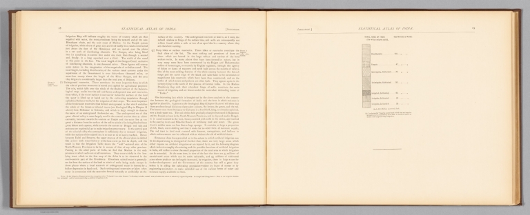
1-5 of 5
|