|
Author
[Mount, John, Page, Thomas, 1704-1762, Mount and Page]
Full Title
(Title Page) The English pilot for the Southern navigation : describing the sea-coasts, capes, headlands, bays, roads, harbours, rivers and ports : together with the soundings, sands, rocks and dangers on the coast of England, Scotland, Ireland, Holland, Flanders, Spain, Portugal, to the Streight's-Mouth, with the coasts of Barbary, and off to the Canary, Madeira, Cape de Verde and Western-Islands : shewing the courses and distances from one place to another, the setting of the tides and currents, the ebbing and flowing of the sea, &c. London : Printed for J. Mount and T. Page, on Tower Hill. M,DCC,LII (1752).
List No
13251.003
Note
Title page to the Part I: 'The English pilot for the Southern navigation". 1752.
Author
[Mount, John, Page, Thomas, 1704-1762, Mount and Page]
Full Title
A draught of the sands, shoals, buoys, beacons & sea marks from the coast of the England from the south Foreland to Orford. (to accompany) The English pilot for the Southern navigation .... London : Printed for J. Mount and T. Page, on Tower Hill. M,DCC,LII (1752).
List No
13251.005
Note
Double page engraved navigation chart, with 2 insets: The River Thames and continuation of map. Depths shown by soundings. Showing the course of the principal tracts and their distances from place to place. Includes decorative title and scale bar cartouche, compass rose and vignettes of light houses and sailing ships.
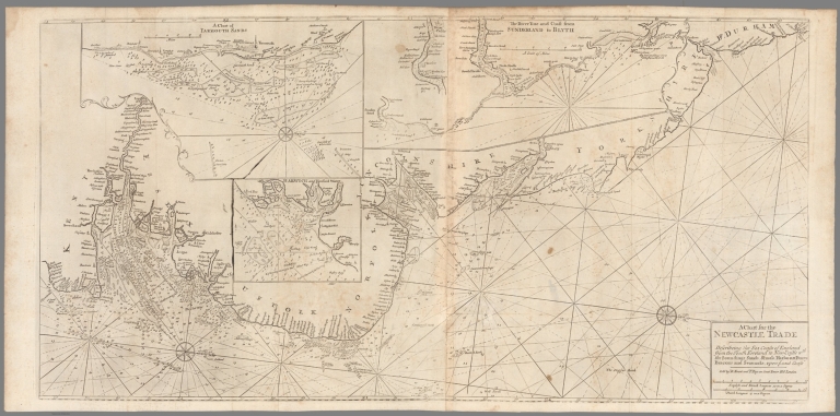
Author
[Mount, John, Page, Thomas, 1704-1762, Mount and Page]
Full Title
A chart for the Newcastle trade describeing the sea coasts of England from the south foreland to New-Castle wth. the soundings, sands, shoals, harbours, buoys, beacons and seamarks upon the said coast. Sold by R. Mount and T. Page, London. (to accompany) The English pilot for the Southern navigation .... London : Printed for J. Mount and T. Page, on Tower Hill. M,DCC,LII (1752).
List No
13251.009
Note
Folded engraved navigation chart of Eastern England, with 3 insets: A Chart of Yarmouth Sands -- The River Tine and coast from Sunderland to Blyth -- Harwich and Hanford Water. Includes compass rose. Depths shown by soundings. Showing the course of the principal tracts and their distances from place to place.
Author
[Apres de Mannevillette, Jean-Baptiste-Nicolas-Denis d', 1707-1780, Depot General de la Marine]
Full Title
Plan du Cap de Bonne Esperance et de ses Environs leve geometriquement en 1752 ... Guill. De La Haye. (to accompany) Neptune Oriental. De d'Apres.
List No
13102.012
Note
Chart of Cape of Good Hope. Shows place names. Relief shown pictorially. Depths shown by soundings.
Author
[Bellin, Jacques Nicolas, 1703-1772, Depot de la Marine]
Full Title
Carte Reduite des Isles Philippines.
List No
12059.130
Note
From J.F. Letenneur: "Exceptional onboard document of this rare and fabulous maritime atlas, a masterpiece by the greatest French hydrographer of the 18th century, with maps of all the coastlines known at the time. Bound with the coat of arms of the King of France, the atlas was taken by the English aboard the frigate la Nymphe, off the coasts of Ushant August 10, 1780, during one of the naval battles of the American War of Independence which took place on European waters. In the context of the war at the end of the 18th century, and of the rivalry between the French and British Navy, maritime atlases, were strategic tools, and this “Hydrographie Françoise” more so than any other, because its purpose was to provide the best maritime charts for the French ships that were fighting on the American side against the British. (The handwritten captions throughout most of the atlas are prices for individual maps and all include the same mention: “for sailors”). These atlases were not the kind to be kept in a library, but precious tools, based on the observations of the travelers and continuously improved upon, as reflect in the present copy. It was bound with the engraved title page of the edition of 1737-1765, but the index includes maps printed after 1765 (until 1772), and the copy was augmented by six maps that do not appear in the index (until 1776), as well as 14 pages of text from the Versailles edition of 1773. The later maps are signed by Verdun de la Crenne and were done during the campaigns of the Flore (1771-1772) and of the Isis led by Fleurieu in 1768-1769. The captions explain that the maps were created using the latest technology of the day that could measure longitude (maritime clocks)." (Continued in the Pub Note field).
Author
[Mount, John, Page, Thomas, 1704-1762, Mount and Page]
Full Title
(Text Page) The English pilot for the Southern navigation : describing the sea-coasts, capes, headlands, bays, roads, harbours, rivers and ports : together with the soundings, sands, rocks and dangers on the coast of England, Scotland, Ireland, Holland, Flanders, Spain, Portugal, to the Streight's-Mouth, with the coasts of Barbary, and off to the Canary, Madeira, Cape de Verde and Western-Islands ... London : Printed for J. Mount and T. Page, on Tower Hill. M,DCC,LII (1752).
List No
13251.002
Note
Gift inscription from Adie Atkinson to John Atkinson, dated 1755.
Author
[Mount, John, Page, Thomas, 1704-1762, Mount and Page]
Full Title
(Text Page to) The English pilot for the Southern navigation : describing the sea-coasts, capes, headlands, bays, roads, harbours, rivers and ports : together with the soundings, sands, rocks and dangers on the coast of England, Scotland, Ireland, Holland, Flanders, Spain, Portugal, to the Streight's-Mouth, with the coasts of Barbary, and off to the Canary, Madeira, Cape de Verde and Western-Islands : shewing the courses and distances from one place to another, the setting of the tides and currents, the ebbing and flowing of the sea, &c. London : Printed for J. Mount and T. Page, on Tower Hill. M,DCC,LII (1752).
List No
13251.004
Note
Ownership inscription.
Author
[Mount, John, Page, Thomas, 1704-1762, Mount and Page]
Full Title
(Text Page to) Direction to sail from the Mouth of the River Thames to Orford-Ness. (to accompany) The English pilot for the Southern navigation .... London : Printed for J. Mount and T. Page, on Tower Hill. M,DCC,LII (1752).
List No
13251.006
Note
Descriptive text of the Mouth of the River Thames to Orford-Ness.
Author
[Mount, John, Page, Thomas, 1704-1762, Mount and Page]
Full Title
(Text Page to) Direction to sail from the Mouth of the River Thames to Orford-Ness. (to accompany) The English pilot for the Southern navigation .... London : Printed for J. Mount and T. Page, on Tower Hill. M,DCC,LII (1752).
List No
13251.007
Note
Descriptive text of the Mouth of the River Thames to Orford-Ness.
Author
[Mount, John, Page, Thomas, 1704-1762, Mount and Page]
Full Title
(Text Page to) Direction to sail from the Mouth of the River Thames to Orford-Ness. (to accompany) The English pilot for the Southern navigation .... London : Printed for J. Mount and T. Page, on Tower Hill. M,DCC,LII (1752).
List No
13251.008
Note
Descriptive text of the Mouth of the River Thames to Orford-Ness.
Author
[Mount, John, Page, Thomas, 1704-1762, Mount and Page]
Full Title
(Text Page to) To Sail between Orford-ness and Burnham. (to accompany) The English pilot for the Southern navigation .... London : Printed for J. Mount and T. Page, on Tower Hill. M,DCC,LII (1752).
List No
13251.010
Note
Descriptive text. Includes 11 woodcut coastal profiles, showing churches and castles. Relief shown pictorially. Depth shown by soundings.
Author
[Mount, John, Page, Thomas, 1704-1762, Mount and Page]
Full Title
(Text Page to) To Sail between Orford-ness and Burnham. (to accompany) The English pilot for the Southern navigation .... London : Printed for J. Mount and T. Page, on Tower Hill. M,DCC,LII (1752).
List No
13251.011
Note
Descriptive text. Includes 11 woodcut coastal profiles, showing churches and castles. Relief shown pictorially. Depth shown by soundings.
Author
[Mount, John, Page, Thomas, 1704-1762, Mount and Page]
Full Title
(Text Page to) To Sail between Orford-ness and Burnham. (to accompany) The English pilot for the Southern navigation .... London : Printed for J. Mount and T. Page, on Tower Hill. M,DCC,LII (1752).
List No
13251.012
Note
Descriptive text. Includes 11 woodcut coastal profiles, showing churches and castles. Relief shown pictorially. Depth shown by soundings.
Author
[Mount, John, Page, Thomas, 1704-1762, Mount and Page]
Full Title
A new chart of the sea coast of Scotland with the islands thereof. Sold by W. & J. Mount and T. Page, London. (to accompany) The English pilot for the Southern navigation .... London : Printed for J. Mount and T. Page, on Tower Hill. M,DCC,LII (1752).
List No
13251.013
Note
Engraved folded navigation chart of cost of Scotland, with inset: A plan of Holy Island and Staples. Depths shown by soundings. Showing the course of the principal tracts from place to place. Includes Compass rose and rhimblines.
Author
[Mount, John, Page, Thomas, 1704-1762, Mount and Page]
Full Title
(Text Page to) To sail between Flamborough-Head and Berwick. A Description of the East-Coast of Scotland, From Berwick to Bokannais. (to accompany) The English pilot for the Southern navigation .... London : Printed for J. Mount and T. Page, on Tower Hill. M,DCC,LII (1752).
List No
13251.014
Note
Descriptive text of North coast of England and East coast of Scotland.
Author
[Mount, John, Page, Thomas, 1704-1762, Mount and Page]
Full Title
(Text Page to) To sail between Flamborough-Head and Berwick. A Description of the East-Coast of Scotland, From Berwick to Bokannais. (to accompany) The English pilot for the Southern navigation .... London : Printed for J. Mount and T. Page, on Tower Hill. M,DCC,LII (1752).
List No
13251.015
Note
Descriptive text of North coast of England and East coast of Scotland.
Author
[Mount, John, Page, Thomas, 1704-1762, Mount and Page]
Full Title
(Text Page to) To sail between Flamborough-Head and Berwick. A Description of the East-Coast of Scotland, From Berwick to Bokannais. (to accompany) The English pilot for the Southern navigation .... London : Printed for J. Mount and T. Page, on Tower Hill. M,DCC,LII (1752).
List No
13251.016
Note
Descriptive text of North coast of England and East coast of Scotland.
Author
[Mount, John, Page, Thomas, 1704-1762, Mount and Page]
Full Title
(Text Page to) A Description of the Coast of Flanders and the Flemitsh Banks. (to accompany) The English pilot for the Southern navigation .... London : Printed for J. Mount and T. Page, on Tower Hill. M,DCC,LII (1752).
List No
13251.017
Note
Descriptive text of the Coast of Flanders.
Author
[Mount, John, Page, Thomas, 1704-1762, Mount and Page]
Full Title
(Text Page to) A Description of the Coast of Flanders and the Flemitsh Banks. (to accompany) The English pilot for the Southern navigation .... London : Printed for J. Mount and T. Page, on Tower Hill. M,DCC,LII (1752).
List No
13251.018
Note
Descriptive text of the Coast of Flanders. Includes coastal profiles.
Author
[Mount, John, Page, Thomas, 1704-1762, Mount and Page]
Full Title
(Text Page to) A Description of the Coast of Flanders and Zealand. A description of the Channels of Teer-Veer, Zierickzee, and Brewers-Haven. (to accompany) The English pilot for the Southern navigation .... London : Printed for J. Mount and T. Page, on Tower Hill. M,DCC,LII (1752).
List No
13251.019
Note
Descriptive text of the Coast of Zealand.
Author
[Mount, John, Page, Thomas, 1704-1762, Mount and Page]
Full Title
A chart of the seacoasts of England, Flanders & Holland. Shewing all the sands, shoals, rocks and dangers, the bayes, roads, harbours, buoyes, beacons and seamarks on the said coasts. Sold by W. & J. Mount and T. Page, London. (to accompany) The English pilot for the Southern navigation .... London : Printed for J. Mount and T. Page, on Tower Hill. M,DCC,LII (1752).
List No
13251.020
Note
Engraved double page navigation chart. Depths shown by soundings. Showing the course of the principal tracts from place to place. Includes Compass rose and rhimblines.
Author
[Mount, John, Page, Thomas, 1704-1762, Mount and Page]
Full Title
(Text Page to) A Description of the Coast of Flanders and Zealand. A description of the Channels of Goerees-Gat and Maes. (to accompany) The English pilot for the Southern navigation .... London : Printed for J. Mount and T. Page, on Tower Hill. M,DCC,LII (1752).
List No
13251.021
Note
Descriptive text of the Coast of Zealand and A description of the Channels of Goerees-Gat and Maes.. Includes 2 coastal profiles.
Author
[Mount, John, Page, Thomas, 1704-1762, Mount and Page]
Full Title
(Text Page to) A Description of the Coast of Flanders and Zealand. A description of the Channels of Goerees-Gat and Maes. (to accompany) The English pilot for the Southern navigation .... London : Printed for J. Mount and T. Page, on Tower Hill. M,DCC,LII (1752).
List No
13251.022
Note
Descriptive text of the Coast of Hollands Includes coastal profiles.
Author
[Mount, John, Page, Thomas, 1704-1762, Mount and Page]
Full Title
(Text Page to) A Description of the Coast of Flanders and Zealand. A description of the Channels of Goerees-Gat and Maes. (to accompany) The English pilot for the Southern navigation .... London : Printed for J. Mount and T. Page, on Tower Hill. M,DCC,LII (1752).
List No
13251.023
Note
Descriptive text of the Coast of Hollands Includes coastal profiles.
Author
[Mount, John, Page, Thomas, 1704-1762, Mount and Page]
Full Title
(Text Page to) A description of the Coast of England, from the River Thames to Downs, and from Tence to Westwrd. (to accompany) The English pilot for the Southern navigation .... London : Printed for J. Mount and T. Page, on Tower Hill. M,DCC,LII (1752).
List No
13251.024
Note
Descriptive text of the Coast England.
Author
[Mount, John, Page, Thomas, 1704-1762, Mount and Page]
Full Title
(Text Page to) A description of the Coast of England, from the River Thames to Downs, and from Tence to Westwrd. (to accompany) The English pilot for the Southern navigation .... London : Printed for J. Mount and T. Page, on Tower Hill. M,DCC,LII (1752).
List No
13251.025
Note
Descriptive text of the Coast England.
Author
[Mount, John, Page, Thomas, 1704-1762, Mount and Page]
Full Title
(Text Page to) A description of the Coast of England, from the River Thames to Downs, and from Tence to Westwrd. (to accompany) The English pilot for the Southern navigation .... London : Printed for J. Mount and T. Page, on Tower Hill. M,DCC,LII (1752).
List No
13251.026
Note
Descriptive text of the Coast England.
Author
[Mount, John, Page, Thomas, 1704-1762, Mount and Page]
Full Title
A new chart of England, Scotland and Ireland. Sold by W. & J. Mount and T. Page, London. (to accompany) The English pilot for the Southern navigation .... London : Printed for J. Mount and T. Page, on Tower Hill. M,DCC,LII (1752).
List No
13251.027
Note
Engraved double page navigation chart. Depths shown by soundings. Showing the course of the principal tracts from place to place. Includes Compass rose, Title cartuche and coat of arms. "A Scale of English & French Leagues".
Author
[Mount, John, Page, Thomas, 1704-1762, Mount and Page]
Full Title
(Text Page to) Directions between Plymouth and Falmouth. (to accompany) The English pilot for the Southern navigation .... London : Printed for J. Mount and T. Page, on Tower Hill. M,DCC,LII (1752).
List No
13251.028
Note
Descriptive text of the Coast England. Includes profiles.
Author
[Mount, John, Page, Thomas, 1704-1762, Mount and Page]
Full Title
(Text Page to) Directions between Plymouth and Falmouth. Directions from the Isle of Wight to Portland. (to accompany) The English pilot for the Southern navigation .... London : Printed for J. Mount and T. Page, on Tower Hill. M,DCC,LII (1752).
List No
13251.029
Note
Descriptive text of the Coast England. Includes profiles.
Author
[Mount, John, Page, Thomas, 1704-1762, Mount and Page]
Full Title
(Text Page to) Directions between Portland and the Lizrd. (to accompany) The English pilot for the Southern navigation .... London : Printed for J. Mount and T. Page, on Tower Hill. M,DCC,LII (1752).
List No
13251.030
Note
Descriptive text of the Coast England.
Author
[Mount, John, Page, Thomas, 1704-1762, Mount and Page]
Full Title
(Text Page to) Directions between Plymouth and Falmouth. (to accompany) The English pilot for the Southern navigation .... London : Printed for J. Mount and T. Page, on Tower Hill. M,DCC,LII (1752).
List No
13251.031
Note
Descriptive text of the Coast England.
Author
[Mount, John, Page, Thomas, 1704-1762, Mount and Page]
Full Title
(Text Page to) Directions between Plymouth and Falmouth. (to accompany) The English pilot for the Southern navigation .... London : Printed for J. Mount and T. Page, on Tower Hill. M,DCC,LII (1752).
List No
13251.032
Note
Descriptive text of the Coast England. Includes coastal profiles.
Author
[Mount, John, Page, Thomas, 1704-1762, Mount and Page]
Full Title
(Text Page to) Directions between Lizard and Isles of Scilly. (to accompany) The English pilot for the Southern navigation .... London : Printed for J. Mount and T. Page, on Tower Hill. M,DCC,LII (1752).
List No
13251.033
Note
Descriptive text of the Coast England.
Author
[Mount, John, Page, Thomas, 1704-1762, Mount and Page]
Full Title
A new chart of British Channel. Extending from north foreland to Scilly Isles &c. on the English shore and from Dunkirk to Ushent on the French . Collected from accurate surveys ... by Cpt. Edmd. Halley. Sold by W. & J. Mount and T. Page, London. (to accompany) The English pilot for the Southern navigation .... London : Printed for J. Mount and T. Page, on Tower Hill. M,DCC,LII (1752).
List No
13251.034
Note
Engraved folded navigation chart, with 9 inset profiles. Depths shown by soundings. Showing the course of the principal tracts from place to place. Includes notes, advertisement, compass roses and Title cartouche.
Author
[Mount, John, Page, Thomas, 1704-1762, Mount and Page]
Full Title
(Text Page to) Directions for the Coast of France. A description of the Coast of France from Calais to the River Roan. (to accompany) The English pilot for the Southern navigation .... London : Printed for J. Mount and T. Page, on Tower Hill. M,DCC,LII (1752).
List No
13251.035
Note
Descriptive text of the Coast France.
Author
[Mount, John, Page, Thomas, 1704-1762, Mount and Page]
Full Title
(Text Page to) Directions for the Coast of France. A description of the Coast of France from Calais to the River Roan. (to accompany) The English pilot for the Southern navigation .... London : Printed for J. Mount and T. Page, on Tower Hill. M,DCC,LII (1752).
List No
13251.036
Note
Descriptive text of the Coast France.
Author
[Mount, John, Page, Thomas, 1704-1762, Mount and Page]
Full Title
(Text Page to) Directions for the Coast of France. A description of the Coast of Normandy ... (to accompany) The English pilot for the Southern navigation .... London : Printed for J. Mount and T. Page, on Tower Hill. M,DCC,LII (1752).
List No
13251.037
Note
Descriptive text of the Coast France. Includes coastal profiles.
Author
[Mount, John, Page, Thomas, 1704-1762, Mount and Page]
Full Title
(Text Page to) Directions for the Coast of France. (to accompany) The English pilot for the Southern navigation .... London : Printed for J. Mount and T. Page, on Tower Hill. M,DCC,LII (1752).
List No
13251.038
Note
Descriptive text of the Coast France. Includes coastal profiles.
Author
[Mount, John, Page, Thomas, 1704-1762, Mount and Page]
Full Title
(Text Page to) Directions for the Coast of France. (to accompany) The English pilot for the Southern navigation .... London : Printed for J. Mount and T. Page, on Tower Hill. M,DCC,LII (1752).
List No
13251.039
Note
Descriptive text of the Coast France.
Author
[Mount, John, Page, Thomas, 1704-1762, Mount and Page]
Full Title
(Text Page to) Directions for the Coast of France. (to accompany) The English pilot for the Southern navigation .... London : Printed for J. Mount and T. Page, on Tower Hill. M,DCC,LII (1752).
List No
13251.040
Note
Descriptive text of the Coast France.
Author
[Mount, John, Page, Thomas, 1704-1762, Mount and Page]
Full Title
(Text Page to) A Description of the West-Coast of England from the Land's-end to the Isle of Man. (to accompany) The English pilot for the Southern navigation .... London : Printed for J. Mount and T. Page, on Tower Hill. M,DCC,LII (1752).
List No
13251.041
Note
Descriptive text of the West coast of England.
Author
[Mount, John, Page, Thomas, 1704-1762, Mount and Page]
Full Title
(Text Page to) A Description of the West-Coast of England from the Land's-end to the Isle of Man. (to accompany) The English pilot for the Southern navigation .... London : Printed for J. Mount and T. Page, on Tower Hill. M,DCC,LII (1752).
List No
13251.042
Note
Descriptive text of the West coast of England and coast of Wales.
Author
[Mount, John, Page, Thomas, 1704-1762, Mount and Page]
Full Title
(Text Page to) A Description of the West-Coast of England from the Land's-end to the Isle of Man. (to accompany) The English pilot for the Southern navigation .... London : Printed for J. Mount and T. Page, on Tower Hill. M,DCC,LII (1752).
List No
13251.043
Note
Descriptive text of the West coast of England and coast of Chester and Liverpool.
Author
[Mount, John, Page, Thomas, 1704-1762, Mount and Page]
Full Title
A chart of the coasts of Ireland and part of England . Sold by Willm. Mount and Thos. Page, London. (to accompany) The English pilot for the Southern navigation .... London : Printed for J. Mount and T. Page, on Tower Hill. M,DCC,LII (1752).
List No
13251.044
Note
Engraved double page navigation chart. Depths shown by soundings. Showing the course of the principal tracts from place to place. compass roses.
Author
[Mount, John, Page, Thomas, 1704-1762, Mount and Page]
Full Title
The channel and city of Dublin . The County of Waterford. Wexfor County. County of Wicklow. (to accompany) The English pilot for the Southern navigation .... London : Printed for J. Mount and T. Page, on Tower Hill. M,DCC,LII (1752).
List No
13251.045
Note
2 engraved double page navigation chart on 1 sheet. Depths shown by soundings. Showing the course of the principal tracts from place to place. compass roses.
Author
[Mount, John, Page, Thomas, 1704-1762, Mount and Page]
Full Title
(Text Page to) A Description of the sea-coast round the Kingdom of Ireland. (to accompany) The English pilot for the Southern navigation .... London : Printed for J. Mount and T. Page, on Tower Hill. M,DCC,LII (1752).
List No
13251.046
Note
Descriptive text of the coast of Ireland.
Author
[Mount, John, Page, Thomas, 1704-1762, Mount and Page]
Full Title
(Text Page to) a Description of the sea-coast round the Kingdom of Ireland. (to accompany) The English pilot for the Southern navigation .... London : Printed for J. Mount and T. Page, on Tower Hill. M,DCC,LII (1752).
List No
13251.047
Note
Descriptive text of the coast of Ireland.
Author
[Mount, John, Page, Thomas, 1704-1762, Mount and Page]
Full Title
(Text Page to) a Description of the sea-coast round the Kingdom of Ireland. (to accompany) The English pilot for the Southern navigation .... London : Printed for J. Mount and T. Page, on Tower Hill. M,DCC,LII (1752).
List No
13251.048
Note
Descriptive text of the coast of Ireland. Includes coastal profiles.
Author
[Mount, John, Page, Thomas, 1704-1762, Mount and Page]
Full Title
A chart of the seacoasts of Ireland from Dublin to London-derry. (to accompany) The English pilot for the Southern navigation .... London : Printed for J. Mount and T. Page, on Tower Hill. M,DCC,LII (1752).
List No
13251.049
Note
Engraved double page navigation chart, with inset: Lough Foyle or the passage to Londonderry. Depths shown by soundings. Showing the course of the principal tracts from place to place. Includes compass rose. Relief shown pictorially.
|