|
Author
[Nusret, Milford Haven, Louis Alexander Mountbatten, Marquis of, 1854-1921]
Full Title
(Text Page to) [Example 1]. -- [Map 1].
List No
14475.007
Note
Description of navigation in [Martin'in manevra levhasiyla Batenberg'in rota müs'irinin sûret-i istimaline mahsûs talimat], Example 1. Text in Arabic, printed in black and red. With associated circular map on facing page, also printed in black and red. Includes a legend, bar scale and notes. Map features the route of a vessel by Prince Louis Alexander of Battenberg (1854-1921), a British naval officer and the first Marquess of Milford Haven, who commanded the British Atlantic Fleet from 1908 to 1910 and became First Sea Lord in 1912. Text in this volume was translated by Nusret - a lieutenant in the Ottoman Naval Forces - for use by Turkish naval officers. Map is 20 x 20 cm, on sheet 28 x 28 cm.
Author
[Nusret, Milford Haven, Louis Alexander Mountbatten, Marquis of, 1854-1921]
Full Title
(Text Page to) [Example 2]. -- [Map 2].
List No
14475.008
Note
Description of navigation in [Martin'in manevra levhasiyla Batenberg'in rota müs'irinin sûret-i istimaline mahsûs talimat], Example 2. Text in Arabic, printed in black. With associated circular map on facing page, printed in black and red. Includes a legend, bar scale and notes. Map features the route of a vessel by Prince Louis Alexander of Battenberg (1854-1921), a British naval officer and the first Marquess of Milford Haven, who commanded the British Atlantic Fleet from 1908 to 1910 and became First Sea Lord in 1912. Text in this volume was translated by Nusret - a lieutenant in the Ottoman Naval Forces - for use by Turkish naval officers. Map is 20 x 20 cm, on sheet 28 x 28 cm.
Author
[Nusret, Milford Haven, Louis Alexander Mountbatten, Marquis of, 1854-1921]
Full Title
(Text Page to) [Example 3]. -- [Map 3].
List No
14475.009
Note
Description of navigation in [Martin'in manevra levhasiyla Batenberg'in rota müs'irinin sûret-i istimaline mahsûs talimat], Example 3. Text in Arabic, printed in black and red. With associated circular map on facing page, also printed in black and red. Includes a legend, bar scale and notes. Map features the route of a vessel by Prince Louis Alexander of Battenberg (1854-1921), a British naval officer and the first Marquess of Milford Haven, who commanded the British Atlantic Fleet from 1908 to 1910 and became First Sea Lord in 1912. Text in this volume was translated by Nusret - a lieutenant in the Ottoman Naval Forces - for use by Turkish naval officers. Map is 20 x 20 cm, on sheet 28 x 28 cm.
Author
[Nusret, Milford Haven, Louis Alexander Mountbatten, Marquis of, 1854-1921]
Full Title
(Text Page to) [Example 4]. -- [Map 4].
List No
14475.010
Note
Description of navigation in [Martin'in manevra levhasiyla Batenberg'in rota müs'irinin sûret-i istimaline mahsûs talimat], Example 4. Text in Arabic, printed in black and red. With associated circular map on facing page, also printed in black and red. Includes a legend, bar scale and notes. Map features the route of a vessel by Prince Louis Alexander of Battenberg (1854-1921), a British naval officer and the first Marquess of Milford Haven, who commanded the British Atlantic Fleet from 1908 to 1910 and became First Sea Lord in 1912. Text in this volume was translated by Nusret - a lieutenant in the Ottoman Naval Forces - for use by Turkish naval officers. Map is 20 x 20 cm, on sheet 28 x 28 cm.
Author
[Nusret, Milford Haven, Louis Alexander Mountbatten, Marquis of, 1854-1921]
Full Title
(Text Page to) [Example 5]. -- [Map 5].
List No
14475.011
Note
Description of navigation in [Martin'in manevra levhasiyla Batenberg'in rota müs'irinin sûret-i istimaline mahsûs talimat], Example 5. Text in Arabic, printed in black. With associated circular map on facing page, printed in black and red. Includes a legend, bar scale and notes. Map features the route of a vessel by Prince Louis Alexander of Battenberg (1854-1921), a British naval officer and the first Marquess of Milford Haven, who commanded the British Atlantic Fleet from 1908 to 1910 and became First Sea Lord in 1912. Text in this volume was translated by Nusret - a lieutenant in the Ottoman Naval Forces - for use by Turkish naval officers. Map is 20 x 20 cm, on sheet 28 x 28 cm.
Author
[Nusret, Milford Haven, Louis Alexander Mountbatten, Marquis of, 1854-1921]
Full Title
(Text Page to) [Example 6]. -- [Map 6].
List No
14475.012
Note
Description of navigation in [Martin'in manevra levhasiyla Batenberg'in rota müs'irinin sûret-i istimaline mahsûs talimat], Example 6. Text in Arabic, printed in black and red. With associated circular map on facing page, also printed in black and red. Includes a legend, bar scale and notes. Map features the route of a vessel by Prince Louis Alexander of Battenberg (1854-1921), a British naval officer and the first Marquess of Milford Haven, who commanded the British Atlantic Fleet from 1908 to 1910 and became First Sea Lord in 1912. Text in this volume was translated by Nusret - a lieutenant in the Ottoman Naval Forces - for use by Turkish naval officers. Map is 20 x 20 cm, on sheet 28 x 28 cm. Text continues on subsequent pages.
Author
Heather, William, 1764-1812
Full Title
The Strait of Gibraltar. By Don Vincente Tofino. Stephenson engraver. (to accompany) The new Mediterranean Harbour pilot. By William Heather ... London : Printed for and published by J.W. Norie and Co., 1814.
List No
13404.005
Note
Engraved nautical chart of Strait of Gibraltar. Includes profile: "Appearance of the land as seen from the Pearl Rock, at the entrance to the Bay of Gibraltar ..."
Author
Heather, William, 1764-1812
Full Title
The Strait of Bonifacio. By M. Thomas Clements. Stephenson engraver. London, Published as the act directs, February 1st. 1809, by William Heather, at the Navigation Warehouse. (to accompany) The new Mediterranean Harbour pilot. By William Heather ... London : Printed for and published by J.W. Norie and Co., 1814.
List No
13404.006
Note
Engraved nautical chart of the Strait of Bonifacio, Corsica.
Author
Heather, William, 1764-1812
Full Title
The coast of Egypt. The passage of Dardanells. By W. Heather.Stephenson engraver. London, Published as the act directs, February 1st. 1809, by William Heather, at the Navigation Warehouse. (to accompany) The new Mediterranean Harbour pilot. By William Heather ...London : Printed for and published by J.W. Norie and Co., 1814.
List No
13404.007
Note
2 engraved nautical chart on 1 plate. Showing the Strait of Dardanelles and Coast of Egypt.
Author
Heather, William, 1764-1812
Full Title
No.1. Gibraltar Bay. No.2. The Bay of Malaga. By Michelot. No. 5. The Bay of Alicant. No. 6. The Port of Yvica, with the channels adjacent. By Vincent Tofino. J. Stephenson, Sc. (to accompany) The new Mediterranean Harbour pilot. By William Heather ... London : Printed for and published by J.W. Norie and Co., 1814.
List No
13404.008
Note
4 engraved nautical charts of the Western Mediterranean on 1 plate. each 15x19. Including: Chart Nos. 1-2, 5-6.
Author
Heather, William, 1764-1812
Full Title
No. 3. The Bay of Almeria. By Michelot. No. 4. The harbor of Carthagena. By Vincente Tofino. No. 7. The Bay of Majorca. By Michelot. No. 8. The Bay of Pollenza and Alcudia. By Vincente Tofino. J. Stephenson, Sc. (to accompany) The new Mediterranean Harbour pilot. By William Heather ... London : Printed for and published by J.W. Norie and Co., 1814.
List No
13404.009
Note
4 engraved nautical charts of Western Mediterranean on 1 plate. each 15x19. Including: Chart Nos. 3-4, 7-8.
Author
Heather, William, 1764-1812
Full Title
No.9. A plan of Port Mahon. By Vin. Tofino. No. 10. A plan of Le Sofa Bay. No. 13. The Bay of Philiou. By Michelot. No. 14. Port Palamos. J. Stephenson, Sc. (to accompany) The new Mediterranean Harbour pilot. By William Heather ... London : Printed for and published by J.W. Norie and Co., 1814.
List No
13404.010
Note
4 engraved nautical charts of Western Mediterranean on 1 plate. each 15x19. Includes inset to chart 9: Entrance to Citadel in Minorca. Including: Chart Nos. 9-1, 14-15.
Author
Heather, William, 1764-1812
Full Title
No.11. The road of Salo. By Ayrouard. No. 12. The Port of Barcelona. By Michelot. No. 15. The Bay of Roses. By Michelot. No. 16. Cadaquie. By Ayrouard. J. Stephenson, Sc. (to accompany) The new Mediterranean Harbour pilot. By William Heather ... London : Printed for and published by J.W. Norie and Co., 1814.
List No
13404.011
Note
4 engraved nautical charts of Western Mediterranean on 1 plate. each 15x19. Including: Chart Nos. 11-12, 15-16.
Author
Heather, William, 1764-1812
Full Title
No.17. Plan of Port Vendre. By Ayrouard. No. 18. The Port of Colioure. By Michelot. No. 21. The Port of Boug. By Ayrouard. No. 22. Bay of Marseilles. By Michelot. J. Stephenson, Sc. (to accompany) The new Mediterranean Harbour pilot. By William Heather ... London : Printed for and published by J.W. Norie and Co., 1814.
List No
13404.012
Note
4 engraved nautical charts of Western Mediterranean on 1 plate. each 15x19. Including: Chart Nos. 17-18, 21-22.
Author
Heather, William, 1764-1812
Full Title
No.19. Port of Agde and fort Brescon. No. 20. The Port of Cette. By Ayrouard. No. 23. The Port of Pormiou from the French. No. 24. Port of Cassis. J. Stephenson, Sc. (to accompany) The new Mediterranean Harbour pilot. By William Heather ... London : Printed for and published by J.W. Norie and Co., 1814.
List No
13404.013
Note
4 engraved nautical charts of Western Mediterranean on 1 plate. each 15x19. Including: Chart Nos. 19-2., 23-24.
Author
Bröuckner, Isaak, 1686-1762.
Full Title
(Index Page to) Carte generale du globe terrestre : dressee sur les memoires les plus approuvés et les observations les plus exactes. 1749. N.F. Sauerbreÿ sculpsit. (to accompany) Nouvel Atlas De Marine... Par Isaac Brouckner ... Approuve par l’ academie Royale des Sciences a Berlin l’ Annee 1749.
List No
13388.002
Note
Hand color Index map. Includes table.
Author
Bröuckner, Isaak, 1686-1762.
Full Title
(Title Page to) Nouvel Atlas De Marine Compose d'une Carte Generale, et de XII Cartes Particulieres, qui Representent Le Globe Terrestre jusqu'au 82.e Degre du Cote du Nord, et jusqu'au 60.e du Cote du Sud : Le tout Dresse sur les Observations les plus Nouvelles et les plus approuvees : Dedie Son Excellence M.gr Le Comte De Schmettau ... par son tres humble et tres obeissant Serviteur Isaac Brouckner Geographe de S.M.T.C. et Correspondant de l'Academie Royale des Sciences de Paris. Approuve par l’ Academie Royale des Sciences a Berlin l’ Annee 1749.
List No
13388.005
Note
Hand colored in outline nautical chart, with title cartouche.
Author
Bröuckner, Isaak, 1686-1762.
Full Title
(Composite Map) Nouvel Atlas De Marine... Par Isaac Brouckner ... Approuve par l’ academie Royale des Sciences a Berlin l’ Annee 1749.
List No
13388.015
Note
Composite map of sheets 1-12: Nouvel Atlas De Marine. 1749.
Author
[Mount, John, Page, Thomas, 1704-1762]
Full Title
The Northern Navigation: According to Mr. Wrights Projection commonly called Mercators Chart.. Sold by W. Mount and T. Page. (to accompany) The English pilot ... northern navigation ... London: Printed for W. and J. Mount, T. Page and Son. M,DCC,LVI. (1756).
List No
13301.004
Note
Folded engraved navigation chart of the Northern Europe coast line. Depth shown by soundings.
Author
[Mount, John, Page, Thomas, 1704-1762, Mount and Page]
Full Title
A draught of the sands, shoals, buoys, beacons & sea marks from the coast of the England from the south Foreland to Orford. (to accompany) The English pilot for the Southern navigation .... London : Printed for J. Mount and T. Page, on Tower Hill. M,DCC,LII (1752).
List No
13251.005
Note
Double page engraved navigation chart, with 2 insets: The River Thames and continuation of map. Depths shown by soundings. Showing the course of the principal tracts and their distances from place to place. Includes decorative title and scale bar cartouche, compass rose and vignettes of light houses and sailing ships.
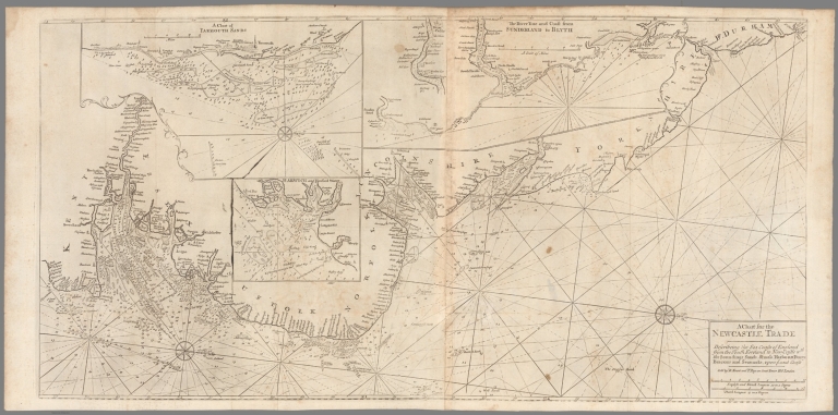
Author
[Mount, John, Page, Thomas, 1704-1762, Mount and Page]
Full Title
A chart for the Newcastle trade describeing the sea coasts of England from the south foreland to New-Castle wth. the soundings, sands, shoals, harbours, buoys, beacons and seamarks upon the said coast. Sold by R. Mount and T. Page, London. (to accompany) The English pilot for the Southern navigation .... London : Printed for J. Mount and T. Page, on Tower Hill. M,DCC,LII (1752).
List No
13251.009
Note
Folded engraved navigation chart of Eastern England, with 3 insets: A Chart of Yarmouth Sands -- The River Tine and coast from Sunderland to Blyth -- Harwich and Hanford Water. Includes compass rose. Depths shown by soundings. Showing the course of the principal tracts and their distances from place to place.
Author
Pirî Reis, d. 1554?
Full Title
fol. 24b Western hemisphere within a wind rose with the Atlantic Ocean in the center
List No
10108.055
Note
Author's name given on fol. 376b as Raʾīs al-Baḥr Pīrī ibn Muḥammad; author dates preferred by (Walters) cataloger: d. 962 AH / 1555 CE
Author
Pirî Reis, d. 1554?
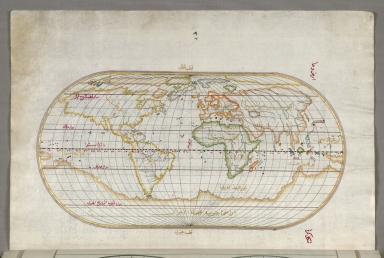
Full Title
fol. 41a Oval world map with the Atlantic Ocean in the center
List No
10108.088
Note
Author's name given on fol. 376b as Raʾīs al-Baḥr Pīrī ibn Muḥammad; author dates preferred by (Walters) cataloger: d. 962 AH / 1555 CE
Author
Pirî Reis, d. 1554?
Full Title
fol. 44b Islands of Semendrek and Imroz in the Aegean Sea
List No
10108.095
Note
Author's name given on fol. 376b as Raʾīs al-Baḥr Pīrī ibn Muḥammad; author dates preferred by (Walters) cataloger: d. 962 AH / 1555 CE
Author
Pirî Reis, d. 1554?
Full Title
fol. 4b Incipit page with illuminated headpiece
List No
10108.015
Note
Author's name given on fol. 376b as Raʾīs al-Baḥr Pīrī ibn Muḥammad; author dates preferred by (Walters) cataloger: d. 962 AH / 1555 CE
Author
Pirî Reis, d. 1554?
Full Title
fol. 23b Oval map of the world with the Pacific Ocean in the center
List No
10108.053
Note
Author's name given on fol. 376b as Raʾīs al-Baḥr Pīrī ibn Muḥammad; author dates preferred by (Walters) cataloger: d. 962 AH / 1555 CE
Author
Pirî Reis, d. 1554?
Full Title
fol. 39b Upper Aegean Sea with the islands of Imbros and Bozca
List No
10108.085
Note
Author's name given on fol. 376b as Raʾīs al-Baḥr Pīrī ibn Muḥammad; author dates preferred by (Walters) cataloger: d. 962 AH / 1555 CE
Author
Pirî Reis, d. 1554?
Full Title
fol. 40b World map in a double hemisphere
List No
10108.087
Note
Author's name given on fol. 376b as Raʾīs al-Baḥr Pīrī ibn Muḥammad; author dates preferred by (Walters) cataloger: d. 962 AH / 1555 CE
Author
Pirî Reis, d. 1554?
Full Title
fol. 43a Island of Bozjah off the coast of Anatolia
List No
10108.092
Note
Author's name given on fol. 376b as Raʾīs al-Baḥr Pīrī ibn Muḥammad; author dates preferred by (Walters) cataloger: d. 962 AH / 1555 CE
Author
Pirî Reis, d. 1554?
Full Title
fol. 45b Part of the European coastline with the islands of Semendrek and Imroz in the Aegean Sea further south
List No
10108.097
Note
Author's name given on fol. 376b as Raʾīs al-Baḥr Pīrī ibn Muḥammad; author dates preferred by (Walters) cataloger: d. 962 AH / 1555 CE
Author
Pirî Reis, d. 1554?
Full Title
fol. 47a Island of Lemnos, southwest of Imbroz in the Aegean Sea
List No
10108.100
Note
Author's name given on fol. 376b as Raʾīs al-Baḥr Pīrī ibn Muḥammad; author dates preferred by (Walters) cataloger: d. 962 AH / 1555 CE
Author
Pirî Reis, d. 1554?
Full Title
fol. 49a Area west of the island of Thasos and the Ayion Oros peninsula
List No
10108.104
Note
Author's name given on fol. 376b as Raʾīs al-Baḥr Pīrī ibn Muḥammad; author dates preferred by (Walters) cataloger: d. 962 AH / 1555 CE
Author
Pirî Reis, d. 1554?
Full Title
fol. 51a Bay of Salonica
List No
10108.108
Note
Author's name given on fol. 376b as Raʾīs al-Baḥr Pīrī ibn Muḥammad; author dates preferred by (Walters) cataloger: d. 962 AH / 1555 CE
Author
Pirî Reis, d. 1554?
Full Title
fol. 52b Bay of Salonica and the western coastline
List No
10108.111
Note
Author's name given on fol. 376b as Raʾīs al-Baḥr Pīrī ibn Muḥammad; author dates preferred by (Walters) cataloger: d. 962 AH / 1555 CE
Author
Pirî Reis, d. 1554?
Full Title
fol. 56a Islands of Skyros and Euboea
List No
10108.118
Note
Author's name given on fol. 376b as Raʾīs al-Baḥr Pīrī ibn Muḥammad; author dates preferred by (Walters) cataloger: d. 962 AH / 1555 CE
Author
Pirî Reis, d. 1554?
Full Title
fol. 62a Island of Midilli in the northeastern Aegean Sea
List No
10108.130
Note
Author's name given on fol. 376b as Raʾīs al-Baḥr Pīrī ibn Muḥammad; author dates preferred by (Walters) cataloger: d. 962 AH / 1555 CE
Author
Pirî Reis, d. 1554?
Full Title
fol. 62b Sea of Marmara and the islands of the eastern Aegean Sea from Semendrek as far as Chios
List No
10108.131
Note
Author's name given on fol. 376b as Raʾīs al-Baḥr Pīrī ibn Muḥammad; author dates preferred by (Walters) cataloger: d. 962 AH / 1555 CE
Author
Pirî Reis, d. 1554?
Full Title
fol. 63a Eastern Mediterranean, the Aegean, and the Black Sea
List No
10108.132
Note
Author's name given on fol. 376b as Raʾīs al-Baḥr Pīrī ibn Muḥammad; author dates preferred by (Walters) cataloger: d. 962 AH / 1555 CE
Author
Pirî Reis, d. 1554?
Full Title
fol. 63b Western Europe and North Africa
List No
10108.133
Note
Author's name given on fol. 376b as Raʾīs al-Baḥr Pīrī ibn Muḥammad; author dates preferred by (Walters) cataloger: d. 962 AH / 1555 CE
Author
Pirî Reis, d. 1554?
Full Title
fol. 64a
List No
10108.134
Note
Author's name given on fol. 376b as Raʾīs al-Baḥr Pīrī ibn Muḥammad; author dates preferred by (Walters) cataloger: d. 962 AH / 1555 CE
Author
Pirî Reis, d. 1554?
Full Title
fol. 63b and 64a Western Europe, North Africa, Mediterranean, the Aegean, and the Black Sea
List No
10108.135
Note
Author's name given on fol. 376b as Raʾīs al-Baḥr Pīrī ibn Muḥammad; author dates preferred by (Walters) cataloger: d. 962 AH / 1555 CE
Author
Pirî Reis, d. 1554?
Full Title
fol. 68b Anatolian coastline around the Bay of Izmir with two Izmir fortresses
List No
10108.144
Note
Author's name given on fol. 376b as Raʾīs al-Baḥr Pīrī ibn Muḥammad; author dates preferred by (Walters) cataloger: d. 962 AH / 1555 CE
Author
Pirî Reis, d. 1554?
Full Title
fol. 70a Island of Chios facing Kysos fortress on the Anatolian side
List No
10108.147
Note
Author's name given on fol. 376b as Raʾīs al-Baḥr Pīrī ibn Muḥammad; author dates preferred by (Walters) cataloger: d. 962 AH / 1555 CE
Author
Pirî Reis, d. 1554?
Full Title
fol. 73a Detail of the island of Chios with its fortress and other topographical features
List No
10108.153
Note
Author's name given on fol. 376b as Raʾīs al-Baḥr Pīrī ibn Muḥammad; author dates preferred by (Walters) cataloger: d. 962 AH / 1555 CE
Author
Pirî Reis, d. 1554?
Full Title
fol. 74a Island of Psara west of Chios
List No
10108.155
Note
Author's name given on fol. 376b as Raʾīs al-Baḥr Pīrī ibn Muḥammad; author dates preferred by (Walters) cataloger: d. 962 AH / 1555 CE
Author
Pirî Reis, d. 1554?
Full Title
fol. 75b Anatolian coastline facing the island of Samos
List No
10108.158
Note
Author's name given on fol. 376b as Raʾīs al-Baḥr Pīrī ibn Muḥammad; author dates preferred by (Walters) cataloger: d. 962 AH / 1555 CE
Author
Pirî Reis, d. 1554?
Full Title
fol. 77a Anatolian coastline facing the island of Samos
List No
10108.161
Note
Author's name given on fol. 376b as Raʾīs al-Baḥr Pīrī ibn Muḥammad; author dates preferred by (Walters) cataloger: d. 962 AH / 1555 CE
Author
Pirî Reis, d. 1554?
Full Title
fol. 79b Island of Samos
List No
10108.166
Note
Author's name given on fol. 376b as Raʾīs al-Baḥr Pīrī ibn Muḥammad; author dates preferred by (Walters) cataloger: d. 962 AH / 1555 CE
Author
Pirî Reis, d. 1554?
Full Title
fol. 80b Two small islands off the coast of Anatolia south of Samos and east of the city of Balat on the Anatolian side
List No
10108.168
Note
Author's name given on fol. 376b as Raʾīs al-Baḥr Pīrī ibn Muḥammad; author dates preferred by (Walters) cataloger: d. 962 AH / 1555 CE
Author
Pirî Reis, d. 1554?
Full Title
fol. 81b Several islands of the eastern Aegean Sea including Leros and Patmos
List No
10108.170
Note
Author's name given on fol. 376b as Raʾīs al-Baḥr Pīrī ibn Muḥammad; author dates preferred by (Walters) cataloger: d. 962 AH / 1555 CE
|
![Text: [Example 1]. ...](https://www.davidrumsey.com/rumsey/Size2/RUMSEY~8~1/205/14475007.jpg)
![Text: [Example 2]. ...](https://www.davidrumsey.com/rumsey/Size2/RUMSEY~8~1/205/14475008.jpg)
![Text: [Example 3]. ...](https://www.davidrumsey.com/rumsey/Size2/RUMSEY~8~1/205/14475009.jpg)
![Text: [Example 4]. ...](https://www.davidrumsey.com/rumsey/Size2/RUMSEY~8~1/205/14475010.jpg)
![Text: [Example 5]. ...](https://www.davidrumsey.com/rumsey/Size2/RUMSEY~8~1/205/14475011.jpg)
![Text: [Example 6].](https://www.davidrumsey.com/rumsey/Size2/RUMSEY~8~1/205/14475012.jpg)