|
Author
[Flemming, Carl, Kartographaischen Institut]
Full Title
Schweden, Norwegen, Finnland und Danemark. Carl Flemmings Generalkarten. No. 32. Druck und Verlag von Carl Flemming in Glogau. Bearbeitet im kartographaischen Institut der Verlagshandlung.
List No
7831.002
Note
Date estimated
Author
شكوفه مقبل [Şukufe Mukbil]
Full Title
(Scandinavia)
List No
10992.015
Note
Dimensions are sheet size.
Author
Borghi, Bartolomeo, 1750-1821
Full Title
La Svezia come era nella sua prima divisione, e secondo gli ultimi trattati, dell'A. B. Borghi. Firenze 1816.
List No
14255.014
Note
Engraved political map of Sweden, with hand-colored outlines delineating boundaries. Title translates to: [Sweden as it was in its first division, and according to the latest treaties]. Shows political boundaries, topography, drainage, coastlines and islands. Relief shown pictorially. With latitudinal and longitudinal lines, as well as two bar scales. Imprint beneath title. First in a series of four maps (plates 13-16). Map is 30 x 22 cm, on sheet 47 x 35 cm. Descriptive text appears on prior plate (11).
Author
Borghi, Bartolomeo, 1750-1821
Full Title
La Svezia Novissima, del A. B. Borghi. Firenze 1818. Ago. Costa Inc.
List No
14255.015
Note
Engraved political map of Sweden, with hand-colored outlines delineating boundaries. Title translates to: [Sweden, most recently]. Shows political boundaries, topography, drainage, coastlines and islands. Relief shown pictorially. With latitudinal and longitudinal lines, as well as two bar scales. Imprint beneath title. Second in a series of four maps (plates 13-16). Map is 30 x 22 cm, on sheet 47 x 35 cm. Descriptive text appears on prior plate (11).
Author
[Koch, Wilhelm, Opitz, C.]
Full Title
Deutsches Reich. Section 3. Eisenbahn und verkehrsatlas von Europa. Section 3.
List No
13679.012
Note
Railways and traffic map of Germany. Prime meridian: Greenwich. Shows boundaries. Includes list of German states and private railways, Danish, and Swedish private railways.
Author
Hermelin, Samuel Gustaf Benzelstierna
Full Title
Charta ofwer Swerige med Tilgransande Lander : Kongl. Majt. Konung Gustaf IV Adolph : i underdänighet tilegnad af S.G. Hermelin ; Graverad af Fredr. Akrel ; Sammandragen af C.E. Enagrins 1797. (to accompany) Geografiske kartor ofver Swerige. 1805.
List No
13427.004
Note
Hand colored map of Sweden and Finland on the Scandinavian peninsula. Shows administrative and political boundaries. Includes dedication statement.
Author
Hermelin, Samuel Gustaf Benzelstierna
Full Title
Charta ofver Wästerbottn och Svenske Lappmarcken, pa Bergs-Radet Friherre S.G. Hermelins Anstalt och Omkostnad,, efter aldre och nyare Chartor samt observationer vid en Resa ar 1795. Forfattad af Anton Swab ... och af Clas Wallman … Af den sistnamde vidare tilokad Ar 1796. Graverad af Fr. Akrel. (to accompany) Geografiske kartor ofver Swerige. 1805.
List No
13427.005
Note
Hand colored map of Lapland, northern Sweden. Shows administrative boundaries. Prime meridian is Ferro.
Author
Hermelin, Samuel Gustaf Benzelstierna
Full Title
Charta ofver Angermanland, Medelpad och Jamtland, efter den af Landshofdingen Friherre P.A. Ornskold ar 1771 utgifne Charta med Tillaggningar af Friherre S.G. Hermelin 1797. Graverad af G. Broling. (to accompany) Geografiske kartor ofver Swerige. 1805.
List No
13427.006
Note
Hand colored map of Angermanland Province. Based on Ornskold map of 1771. Shows administrative boundaries. Includes explanation.
Author
Hermelin, Samuel Gustaf Benzelstierna
Full Title
Charta ofver Herjeadalen, forfattad efter den af ... Herr Grefve F.A.U. Cronstedt lamnade Charta och efter Observationer vid en Resa ar 1796, af A. Swab ... och C.M. Robsahm ... pa Bergs-Radet Friherre S.G. Hermelins Anstalt och Omkostand, utgifven 1797. (to accompany) Geografiske kartor ofver Swerige. 1805.
List No
13427.007
Note
Hand colored map of Harjedalen, Province. Shows administrative boundaries.
Author
Hermelin, Samuel Gustaf Benzelstierna
Full Title
Charta ofver Gastrikland och Helsingland : Sammandragen under Landshofdigen och Comendeurens af Kongl Nordstjerne Orden Hogwaalborne Herr Grefve F.A.U. Crosntedts infeende, af Ingenieuren Olof Insulander Ar 1796; Utgifven af Frih S.G. Hermelin; Graverad af Fr. Akrel. (to accompany) Geografiske kartor ofver Swerige. 1805.
List No
13427.008
Note
Hand colored map of Gastrikland and Halsingland, Provinces, central Sweden. Shows administrative boundaries. Prime meridan" Ferro.
Author
Hermelin, Samuel Gustaf Benzelstierna
Full Title
Charta ofver Nylands och Tavastehus samt Kymmenegard Hofdingedomen : utgifven af Friherre S.G. Hermelins, och forfattad af C.P. Hallstrom ... 1798. Graverad af Fr. Akrel. (to accompany) Geografiske kartor ofver Swerige. 1805.
List No
13427.014
Note
Hand colored map of the Nyland and Tavastehus province. Shows administrative divisions. Includes notes.
Author
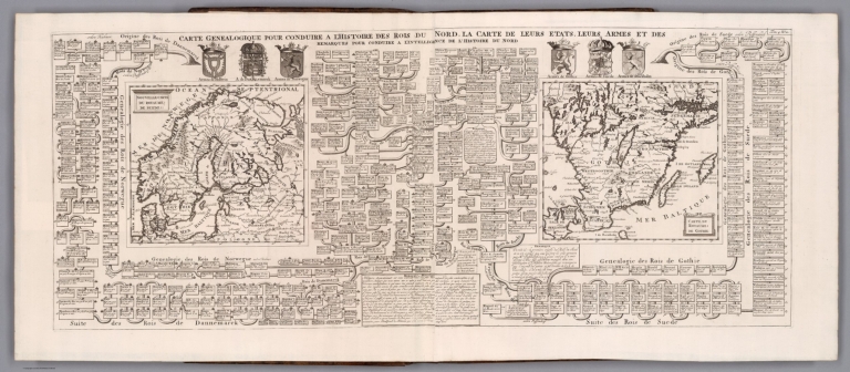
[Chatelain Henri, 1684-1743, Gueudeville, Nicolas]
Full Title
Carte genealogique pour conduire a l'histoire des rois du nord, la carte de leurs etats, leurs armes et des remarques : pour conduire a l'intelligence de l'histoire du nord. Nouvelle carte du royaume de Suede. Carte du royaume de Gothie. Tome 4. No. 2. (to accompany) Atlas Historique ... Tome IV. A Amsterdam, chez les Freres Chatelain Libraires. M DCC XIV (1714).
List No
13272.337
Note
2 engraved maps on 1 folded sheets, with a genealogical tree of the Kingdoms of the Scandinavian countries. Maps represent Scandinavia and Southern Sweden. Includes descriptive text. Relief shown pictorially.
Author
[Brockhaus, F.A., Leeder, Ehrenfried, Leutemann, Heinrich]
Full Title
Schwenden und Norwegen.
List No
6819.061
Note
Lavishly illustrated around margins of map with high quality vignettes of animals, structures and people. Relief shown in hachures.
Author
Ortelius, Abraham, 1527-1598
Full Title
Daniae Regni Typus. Cum Privilegio.
List No
10000.051
Author
Appleton, D. & Co.
Full Title
Norway and Sweden. Copyright 1892 by Appleton & Co. (untitled insets) Stockholm; Christianial. (to accompany) The Library Atlas Of Modern Geography ... New York, D. Appleton And Company 1892. (on upper margin) Norway & Sweden. 23.
List No
0026.050
Note
Color map on 2 sheets. Shows administrative divisions, major cities, roads, railways, canals, forts and fortifications, submarine cables, principal steam routes and distances from place to place, etc. Relief shown by hachures and spot heights in feet. Prime meridian is Greenwich. Map continues on next page.
Full Title
Sweden and Norway. Engraved by F. Shallus. (Boston: Published by Thomas & Andrews. 1812)
List No
0028.015
Note
Engraved map, uncolored. Relief shown by hachures. Covers also Finland and Denmark. Engraver's name partially erased.
Author
Arrowsmith, John
Full Title
Sweden & Norway, by J. Arrowsmith. London, pubd. 15 Feby. 1832 by J. Arrowsmith, 35 Essex Street, Strand.
List No
0036.008
Note
Engraved map. Hand colored boundaries. Relief shown by hachures. Includes inset.
Author
Brue, Adrien Hubert, 1786-1832
Full Title
Carte generale des royaumes de Suede, de Norvege et de Danemark, redigee par A. Brue, Geographe du Roi. (with) Danemark. (with) Islande. (with Iles Faroer). Paris, 1825. Chez l'Auteur, rue des Macons Sorbonne, no. 9, et chez les principaux m(archan)ds de cartes geographiques.
List No
0096.021
Note
Hand colored engraved map. Relief shown by hachures. Prime meridian: Paris.
Author
Colton, G.W.
Full Title
Sweden And Norway. Published By J.H. Colton & Co. No. 172 William St. New York. Entered ... 1855 by J.H. Colton & Co. ... New York. No. 20.
List No
0149.087
Note
In full color by region.
Author
Colton, G.W.
Full Title
Colton's Sweden and Norway. Published By J. H. Colton. No. 172 William St. New York.
List No
0151.084
Note
Prime meridians are Greenwich and Washington D.C. Relief shown by hachures.
Author
Colton, G.W.
Full Title
Colton's Sweden and Norway. Published By G. W & C. B. Colton & Co. No. 172 William St. New York.
List No
0152.086
Note
Prime meridians are Washington D.C. and Greenwich.
Author
Cram, George Franklin
Full Title
Europe in the Time of Napoleon I. Sweden & Norway.
List No
0210.067
Note
Prime meridians Greenwich and Washington.
Author
Delamarche, Felix
Full Title
Norwege, Suede et Danemark ... 1823.
List No
0231.008
Author
[Dower, John, Higgins, W.M.]
Full Title
Sweden and Norway.
List No
0247.042
Author
Duval, Henri
Full Title
Atlas Universel. Tableau historique et Geographique des Royaumes de Danemarck et de Suede. ... Par Henri Duval, Chevalier de la Legion d'honneur, Professeur d'histoire, de geographie, de belles-lettres, &. Paris (1834), Chez l'Auteur, rue de la Chaussee d'Antin, No.15... Johanneau, Rue du Coq. No. 8 bis. ,,, Ate. Foucher.
List No
0254.009
Note
Map of the Scandinavia with chronologies of historic events. Timelines include reigns of French kings for comparative reference. Hand tinted text to match mapped areas.
Author
Finley, Anthony
Full Title
Denmark, Sweden, And Norway. Young & Delleker Sc. Published by A. Finley, Philada. (to accompany) A New General Atlas Comprising a Complete Set of Maps, representing the Grand Divisions Of The Globe ... Philadelphia: Published by Anthony Finley. 1827.
List No
0282.039
Note
Full color map on sheet 35x27. Relief shown pictorially. Prime meridians are Washington and Greenwich. Shows political and administrative divisions, capitals, major cities and rivers.
Author
Finley, Anthony
Full Title
Denmark, Sweden, And Norway. Published by A. Finley Philada. Young & Delleker Sc.
List No
0285.036
Note
Full color.
Author
[Bowen, Emanuel, Gibson, John]
Full Title
Sweden And Norway. (to accompany) Atlas Minimus or a New Set of Pocket Maps of the Several Empires, Kingdoms and States of the Known World, with Historical Extracts relative to each. Drawn and Engraved by J. Gibson from the Best Authorities, Revis'd, Corrected and Improv'd by Eman: Bowen Geographer to His Majesty.
List No
0300.030
Note
First edition. The "Historical Extracts" are short bits of text printed on the maps giving relevant geographical information. A revised edition was published in London in 1792. In 1759, another edition was published adding separate geographical descriptions and correcting some of the maps (see our copy). The Philadelphia 1798 edition by Mathew Carey incorporates the 1759 edition text word for word (excepting the maps of United States which Carey omits in favor of his pocket atlas of the U.S.). Gibson and Bowen made the four sheet map of North America (Stevens 49), and Gibson made the four sheet map of America (Stevens 3).
Author
Johnson, A.J.
Full Title
Johnson's Prussia, Norway, Sweden and Denmark By Johnson and Ward.
List No
0352.054
Note
Full color map of Scandinavia, with heavy outlines around the countries. Includes Sweden, Norway, Finland, Denmark and Prussia, as well as parts of Estonia, Latvia and Lithuania.Accompanied by two vignettes of the Stockholm and Cologne. Show capital cities, cities and towns, waterways, major roadways, and railroads. Relief shown pictorially. Prime meridians are Greenwich and Washington D.C.
Author
Johnson, A.J.
Full Title
Johnson's Sweden and Norway. Entered ... 1865. Johnson's Denmark with Sleswick and Holstein.
List No
0358.060
Author
Johnston, Alexander Keith, 1804-1871
Full Title
Sweden & Norway, Scandinavia by Keith Johnston, F.R.S.E. (with) Stockholm and its environs. Engraved & printed by W. & A.K. Johnston, Edinburgh. William Blackwood & Sons, Edinburgh & London, (1861)
List No
0373.028
Note
Engraved map. Boundaries hand col.; hydrography printed in blue. Relief shown by hachures. Scale of inset (ca. 1:75,000). "Keith Johnston's general atlas 24."
Author
Johnston, Alexander Keith
Full Title
Sweden & Norway (Scandanavia). (with) Stockholm and its environs. By Keith Johnston, F.R.S.E. Keith Johnston's General Atlas. Engraved, Printed, and Published by W. & A.K. Johnston, Edinburgh & London.
List No
0377.028
Note
States and counties outlined in color. Relief shown by hachures. Four scales. One inset.
Author
Johnston, Alexander Keith
Full Title
Basin of the Baltic. (with) St. Peterburg and its environs. By Keith Johnston, F.R.S.E. Keith Johnston's General Atlas. Engraved, Printed, and Published by W. & A.K. Johnston, Edinburgh & London.
List No
0377.029
Note
Countries outlined in color. Relief shown by hachures. One inset.
Author
Kitchin, Thomas
Full Title
A new map of the Northern States containing the Kingdoms of Sweden, Denmark, and Norway, with the western parts of Russia, Livonia, Courland &ca. (By Thomas Kitchin). London, printed for Robert Sayer, Fleet Street, as the Act directs, October 10th, 1790.
List No
0411.025
Note
Engraved map in outline color. Shows vegetation, banks, etc. Relief shown pictorially. Prime meridian: Ferro. (W 8--E 52/N 72--N 53)
Author
Larousse
Full Title
Suede, Norvege et Danemark.
List No
0418.135
Full Title
Couronnes du Nord comprenant les royaumes de Danemarc, Suede et Norwege. Avec priv. (A Paris, chez Delamarche, Geogr., ca. 1800)
List No
0421.014
Note
Engraved map. Outline hand coloring. Relief shown pictorially. Prime meridian: Ferro.
Author
Lizars, Daniel
Full Title
Scandinavia. Published by D. Lizars, Edinburgh. (with) Iceland. (1831?)
List No
0436.017
Note
Hand colored engraved map. Relief shown by hachures.
Author
Lizars, William Home, 1788-1859
Full Title
Scandinavia :Including Sweden, Norway & Denmark. Published by W.H. Lizars, Edinburgh. (to accompany) Lizars' Edinburgh Geographical General Atlas ... 1841. (inset) Iceland.
List No
0438.024
Note
Double page engraved hand colored in outline map. Relief shown by hachures. Shows political and administrative boundaries, cities, roads, rivers, canals and mountains. Prime meridian is London.
Author
Malte-Brun, Conrad, 1775-1826
Full Title
Suede et Norvege, 1832. No. 43. Grave par Thierry. (1837)
List No
0458.037
Note
Engraved map. Districts trimmed in color. Rivers and lakes shown. Major relief shown by hachures. Includes 2 scales.
Author
Malte-Brun, Conrad, 1775-1826
Full Title
Danemark, 1832. No. 44. Grave par Thierry. (1837)
List No
0458.038
Note
Engraved map. Districts trimmed in color. Rivers and lakes shown. Major relief shown by hachures. Includes 2 scales. Insets of Iselande and Iles Faroe.
Author
[Martin, R.M., Tallis, J. & F.]
Full Title
Sweden and Norway. The Illustrations by J. Marchant & Engraved by J.H. Kernot. The Map Drawn & Engraved by J. Rapkin.
List No
0466.024
Note
Sweden in red outline and Norway in blue outline. Drawings of local peasants, skiers, iron mines, and Stockholm. Surrounded by decorative border.
Author
[Desbuissons, L.E., Migeon, J.]
Full Title
Suede et Norvege. Grave par L. Smith. Dresse Sous La Direction De J. Migeon Par Ch. Lacoste. Migeon, editeur, imp, r. du Moulin Vert, Paris. Ecrit par A. Bizet. (1892). Fillatreau del. and Soudain sc. (for vignette).
List No
0507.039
Note
Full color by state. Relief shown by hachures. Vignettes of Stockholm and Christiania.
Author
Johnson, A.J.
Full Title
Johnson's Sweden And Norway Published by Johnson And Ward. Johnson's Denmark With Sleswick (Schleswig) & Holstein Published by Johnson And Ward.
List No
0535.050
Note
In full color. Denmark map at a scale of 1:1,387,000. Relief shown by hachures. Meridians Greenwich and Washington D.C.
Author
Mitchell, Samuel Augustus
Full Title
Sweden & Norway.
List No
0537.052
Note
In full color by numbered District or Prefecture with key included.
Author
Mitchell, Samuel Augustus
Full Title
Sweden & Norway.
List No
0545.056
Note
Full color map. Includes explanation chart, showing canals, capitals, important towns, etc. Also includes a list of Noeway districts &c., and Sweden prefectures. Prime meridian is Greenwich. Relief shown by hachures.
Author
Mitchell, Samuel Augustus Jr.
Full Title
Russian in Europe, Sweden and Norway. (inset maps) 78. Map of Denmark. 79. Map of Holland and Belgium. Entered ... 1867 by S. Augustus Mitchell, Jr. ... Pennsylvania.
List No
0579.054
Note
Color map by province and counties. Relief shown by hachures. Prime meridians are Greenwich and Washington, D.C.
Author
Mitchell, Samuel Augustus
Full Title
Russia in Europe, Sweden, and Norway. (with) Map of Denmark. (with) Map of Holland and Belgium. Entered ... 1879 by S. Augustus Mitchell ... Washington. (1880)
List No
0586.061
Note
Hand colored map with 2 insets. Relief shown by hachures and spot heights. Shows provinces, settlements, railroads, rivers, etc. Prime meridians: Greenwich and Washington.
Author
Mitchell, Samuel Augustus Jr.
Full Title
Russia in Europe, Sweden, and Norway. (with) Map of Denmark. (with) Map of Holland and Belgium. Copyright by S. Augustus Mitchell 1884.
List No
0592.063
Note
Hand colored map with 2 insets. Relief shown by hachures and spot heights. Shows provinces, settlements, railroads, rivers, etc. Prime meridians: Greenwich and Washington.
Full Title
Russia in Europe, Sweden, and Norway. (with) Map of Denmark. (with) Map of Holland and Belgium. Copyright 1887 by Wm. M. Bradley & Bro. (1890)
List No
0594.061
Note
Hand colored map with 2 insets. Relief shown by hachures and spot heights. Shows provinces, settlements, railroads, rivers, etc. Prime meridians: Greenwich and Washington.
Author
[Morse, Charles W., Colby, Charles A.]
Full Title
Sweden and Norway.
List No
0623.057
|