|
Author
[Fisher, Joseph R., Planters Peanuts (Firm)]
Full Title
Minnesota : The gopher state -- Iowa : The hawkeye state -- Missouri : The show me state -- Kansas : The sunflower state.
List No
14374.011
Note
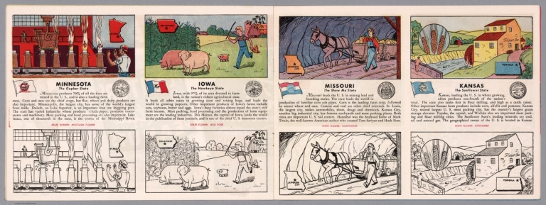
Four views, representing Minnesota, Iowa, Missouri and Kansas. Views show examples of the landscape and natural resources. Each view includes an inset map of the state, which marks the location of the capital city with a star. Accompanied by descriptive text, the state flags, seals and flowers: moccasin flower, wild rose, hawthorne and sunflower, respectively. The view of each state appears both in color (on top) and in black and white (bottom), the latter inviting coloration. Together, views are 18 x 52 cm, on two sheets 20 x 54 cm.
Author
Cram, George Franklin, 1841-1928
Full Title
New railroad and county map of Missouri : Showing latest government surveys. Published by Geo. F. Cram, 262-264 Wabash Ave. Chicago. 1882.
List No
14250.022
Note
Map of Missouri, showing railroads (both proposed and existing), county boundaries, cities and towns, and drainage. Political boundary lines in color. Includes a legend and a bar scale. With index numbers along the perimeter, and decorative border. Also, with two inset maps: The south-eastern extension of Missouri -- [St. Louis and vicinity]. 42 x 52 cm, on sheet 45 x 58.
Author
Appleton, D. & Co.
Full Title
Map of Missouri. Copyright 1891 by Matthews-Northrup Co. ... Buffalo, New York. (inset) City of St. Louis. (to accompany) The Library Atlas Of Modern Geography ... New York, D. Appleton And Company 1892. (on upper margin) Missouri. 79.
List No
0026.202
Note
Color map. Shows county boundaries and county seat, capital, railways, roads, etc. "Size of type indicates importance of the places". Includes notes. Relief shown by hachures. Prime meridians are Greenwich and Washington.
Author
Arbuckle Bros.
Full Title
Missouri, Oregon, Iowa, North Dakota. Copyright 1889 Arbuckle Bros. N.Y.
List No
0027.003
Note
Sheet with maps of four states in full color. Oregon is noted for its salmon fisheries, and the card features a fisherman as well as canned salmon. Little is written about North Dakota, but it is noted that "the temperature varies from 20 degrees below zero to 100 degrees Fahrenheit." Each card measures 7.5 x 12.5 cm.
Author
Asher & Adams
Full Title
Asher & Adams' Missouri. Entered according to Act of Congress in the year 1874 by Asher & Adams ... at Washington. (New York, 1874)
List No
0041.023
Note
Hand col. engraved map. Shows townships, distances along railroads, etc. Prime meridians: Greenwich and Washington.
Author
[Bartholomew, John, Black, Adam & Charles]
Full Title
Missouri and Arkansas. Published by A. & C. Black. Edinburgh. Printed in Colours by Schenck & Macfariane. Edinburgh. Drawn & Engraved by J. Bartholomew, Edinburgh.
List No
0073.013
Note
States outlined in color. Land tinted.
Author
Bradford, Thomas G.
Full Title
Missouri. Entered ... 1838, by T.G. Bradford ... Massachusetts. Engraved by G.W. Boynton.
List No
0089.036
Note
In full color.
Full Title
Carte geographique, statistique et historique du Missouri. Missouri. Grave par B. de Beaupre, Rue de Vaugirard, No. 81, a Paris. Fonderie et Imprimerie de J. Carez. (1825)
List No
0102.034
Note
Hand colored engraved map. Relief shown by hachures. Text and tables at sides and bottom. Prime meridians: Washington and Paris.
Author
Burr, David H., 1803-1875
Full Title
Map of Illinois & Missouri Exhibiting the Post Offices, Post Roads, Canals, Rail Roads, &c. By David H. Burr. (Late Topographer to the Post Office.) Geographer to the House of Representatives of the U.S. John Arrowsmith. Entered ... July 10th, 1839, by David H. Burr ... District of Columbia.
List No
0104.012
Note
In full color by county. Postal routes by coach, stage, sulkey, cross, rail roads and canals shown. In 8 sections mounted on linen. Label on back states "No. 12. Illinois, Missouri."
Author
[Carey, H. C., Lea, I.]
Full Title
Geographical, Historical, And Statistical Map Of Missouri. Missouri. No. 34. Engraved by Young & Delleker.
List No
0122.029
Note
In full color by county or region surrounded by text.
Author
[Carey, H. C., Lea, I.]
Full Title
Geographical, Historical, And Statistical Map Of Arkansas Territory. Map Of Arkansas And Other Territories of the United States Respectfully inscribed to the Hon. J.C. Calhoun Secretary Of War By S.H. Long Major T. Engineers. No. 35. Drawn by S.H. Long Maj. U.S. Engineers. Engraved by Young & Delleker.
List No
0122.030
Note
In full color by region surrounded by text.
Author
Colton, G.W.
Full Title
The City Of St. Louis Missouri. (with) The City Of Chicago Illinois. Published By J.H. Colton & Co. No. 172 William St. New York. Entered ... 1855 by J.H. Colton & Co. ... New York. No. 45.
List No
0149.050
Note
In full color by area. Numerous buildings are shown and labeled. Both maps inside decorative border.
Author
Colton, G.W.
Full Title
Missouri. (with) Vicinity Of St. Louis. Published By J.H. Colton & Co. No. 172 William St. New York. Entered ... 1855 by J.H. Colton & Co. ... New York. No. 46.
List No
0149.051
Note
In full color by county.
Author
Colton, G.W.
Full Title
Colton's Missouri. (inset) Vicinity of St. Louis. Published By J. H. Colton. No. 172 William St. New York.
List No
0151.056
Note
Prime meridians are Greenwich and Washington D.C. Map showing the county boundaries in color.
Author
Colton, G.W.
Full Title
The City of St. Louis, Missouri. The City of Chicago, Illinois. Published By J. H. Colton. No. 172 William St. New York.
List No
0151.057
Note
The plans of Chicago & St. Louis are upon the same scale.
Author
Colton, G.W.
Full Title
The City of St. Louis, Missouri. The City of Chicago, Illinois. Published By G. W & C. B. Colton & Co. No. 172 William St. New York.
List No
0152.055
Note
The plans of Chicago & St. Louis are upon the same scale.
Author
Colton, G.W.
Full Title
Colton's Missouri. (inset) Vicinity of St. Louis. Published By G. W & C. B. Colton & Co. No. 172 William St. New York.
List No
0152.056
Note
Prime meridians are Washington D.C. and Greenwich.
Author
Cram, George Franklin
Full Title
New Rail Road and County Map of Missouri.
List No
0210.033
Note
Prime meridians Greenwich and Washington.
Author
Finley, Anthony
Full Title
Map of the State of Missouri And Territory of Arkansas Compiled From The Latest Authorities. Drawn by D.H. Vance. Engraved by J.H. Young. Published by A. Finley Philadelphia 1826.
List No
0278.012
Note
In full color by county or region. Statistical table breaks down population from the 1820 census by white, blacks, and foreigners not naturalized. Square mileage also noted.
Author
Finley, Anthony
Full Title
Map of the State of Missouri and the Territory of Arkansas, Compiled from the Latest Authorities.
List No
0279.016
Note
Date estimated.
Author
Finley, Anthony
Full Title
Map of the States of Missouri and Territory of Arkansas, Compiled from the Latest Authorities. Drawn by D.H. Vance. Published by A. Finley, Philadelphia. Engraved by J.H. Young.
List No
0280.012
Note
Relief shown by hachures. Prime meridian Washington. Statistical table for each state.
Author
Finley, Anthony
Full Title
Missouri. Young & Delleker Sc. Published by A. Finley, Philada. (to accompany) A New General Atlas Comprising a Complete Set of Maps, representing the Grand Divisions Of The Globe ... Philadelphia: Published by Anthony Finley. 1827.
List No
0282.034
Note
Full color map on sheet 35x27. Relief shown pictorially. Prime meridians are Washington and Greenwich. Shows counties, major cities, roads and rivers.
Author
Finley, Anthony
Full Title
Missouri. Published by A. Finley Philada. Young & Delleker Sc.
List No
0285.030
Note
Full color by county.
Author
Gray, O.W.
Full Title
Gray's Atlas Map of Missouri.
List No
0310.062
Author
[Colton, G.W., Colton, C.B., Gray, O.W.]
Full Title
Missouri. Entered ... 1869 by G.W. & C.B. Colton & Co.
List No
0312.045
Author
Johnson, A.J.
Full Title
Johnson's Missouri And Kansas By Johnson And Ward.
List No
0352.039
Note
Full color by county or region, with heavy outlines around the states. Includes three vignettes: Santa Fe from the Great Missouri Trail, Spearing Fish, and Fire on the Prairie. Shows railroads, roads, and Indian reservations. Prime meridians are Greenwich and Washington D.C. Relief shown by hachures.
Author
Johnson, A.J.
Full Title
Johnson's Missouri and Kansas. Entered ... 1865.
List No
0358.044
Author
Johnson, A.J.
Full Title
Johnson's Missouri And Kansas By Johnson And Ward.
List No
0535.037
Note
In full color by county or region. Includes three vignettes: Santa Fe from the Great Missouri Trail, Spearing Fish, and Fire on the Prairie. Relief shown by hachures. Meridians Greenwich and Washington D.C.
Author
Mitchell, Samuel Augustus
Full Title
A New Map Of Missouri With Its Roads And Distances. Published By S. Augustus Mitchell, N.E. corner of Market & 7th Street Philada., 1846. Entered ... 1846 by H.N. Burroughs ... Pennsylvania.
List No
0537.033
Note
In full color by county with steamboat route distances included.
Author
Mitchell, Samuel Augustus
Full Title
Map of Missouri. Published By S. Augustus Mitchell. N.E. corner of Market & 7th. Streets. Philada. Entered ... 1847 by H.N. Burroughs ... Pennsylvania.
List No
0545.036
Note
Full color map. Prime meridians are Greenwich and Washington D.C.
Author
Mitchell, Samuel Augustus Jr.
Full Title
County map of the States of Iowa and Missouri. Drawn & Engraved by W.H. Gamble. Entered ... 1861 by S. Augustus Mitchell, Jr. ... Pennsylvania.
List No
0572.034
Note
Full color map by county. Prime meridians are Greenwich and Washington, D.C.
Author
Mitchell, Samuel Augustus Jr.
Full Title
County map of the States of Iowa and Missouri. Drawn and Engraved by W.H. Gamble. Entered ... 1867 by S. Augustus Mitchell, Jr. ... Pennsylvania.
List No
0579.036
Note
Color map. Prime meridians are Greenwich and Washington, D.C.
Author
Mitchell, Samuel Augustus Jr.
Full Title
St. Louis. Entered ... 1867 by S. Augustus Mitchell, Jr. ... Pennsylvania.
List No
0579.037
Note
Color map. Showing roads, railroads, etc.
Author
Mitchell, Samuel Augustus
Full Title
St. Louis. Entered ... 1879 by S. Augustus Mitchell ... Washington. (1880)
List No
0586.034
Note
Hand colored. Shows wards, railroads, etc.
Author
Mitchell, Samuel Augustus
Full Title
County & township map of the states of Iowa and Missouri. Drawn & engraved by W.H. Gamble, Philadelphia. Entered ... 1879 by S. Augustus Mitchell ... Washington. (1880)
List No
0586.035
Note
Hand colored. Shows settlements, rivers, etc. Prime meridians: Greenwich and Washington.
Author
Mitchell, Samuel Augustus Jr.
Full Title
St. Louis. Copyright by S. Augustus Mitchell 1884.
List No
0592.037
Note
Hand colored. Shows wards, railroads, etc.
Author
Mitchell, Samuel Augustus Jr.
Full Title
County & township map of the states of Iowa and Missouri. Copyright by S. Augustus Mitchell 1884.
List No
0592.038
Note
Hand colored. Shows settlements, rivers, etc. Prime meridians: Greenwich and Washington.
Author
Mitchell, Samuel Augustus Jr.
Full Title
Plan of Milwaukee. Copyright by S. Augustus Mitchell 1884.
List No
0592.039
Note
Hand colored. Shows settlements, rivers, etc.
Full Title
St. Louis. Copyright 1887 by Wm. M. Bradley & Bro. (1890)
List No
0594.036
Note
Hand colored. Shows wards, railroads, etc.
Full Title
County & township map of the states of Iowa and Missouri. Drawn & engraved by W.H. Gamble, Philadelphia. Copyright 1887 by Wm. M. Bradley & Bro. (1890)
List No
0594.037
Note
Hand colored. Shows settlements, rivers, etc. Prime meridians: Greenwich and Washington.
Author
[Morse, Charles W., Colby, Charles A.]
Full Title
Missouri.
List No
0623.039
Author
Society for the Diffusion of Useful Knowledge (Great Britain)
Full Title
North America sheet IX. Parts of Missouri, Illinois and Indiana. Published under the superintendence of the Society for the Diffusion of Useful Knowledge. Engraved by J. & C. Walker. Published July 1st. 1833 by Baldwin & Cradock, 47 Paternoster Row, London. Printed by Russell, Penge. (London: Chapman & Hall, 1844)
List No
0890.136
Note
Engraved map. Relief shown by hachures. County boundaries hand col. Source: Tanner.
Author
[Stieler, Adolf, Petermann, A.]
Full Title
Stieler's Hand-Atlas ... No. 85. Petermann: Vereinigte Staaten von Nord-Amerika in 6 Blattern, Bl.5.
List No
0960.102
Author
[Stieler, Adolf, Petermann, A.]
Full Title
Stieler's Hand-Atlas ... No. 86. Petermann: Vereinigte Staaten von Nord-Amerika in 6 Blattern, Bl.6. (inset) Florida. Texas.
List No
0960.103
Author
Tanner, Henry S.
Full Title
A New Map of Missouri with Its Roads & Distances by H.S. Tanner.
List No
0976.034
Author
Tanner, Henry S.
Full Title
A New Map Of Missouri With Its Roads & Distances. By H.S. Tanner. Entered ... 1833 by H.S. Tanner ... Pennsylvania. Published by H.S. Tanner No. 144 Chesnut St. Philadelphia. (above neat line) Tanner's Universal Atlas.
List No
0977.029
Note
Full color by county with inset chart of steamboat routes and distances.
Author
Tanner, Henry S.
Full Title
A New Map of Missouri with Its Roads & Distances by H.S. Tanner.
List No
0980.036
Author
U.S. General Land Office
Full Title
State of Missouri. Department of the Interior, General Land Office, October 2nd 1866. Jo. S. Wilson, Commissioner. No. 9. Bowen & Co. Lith. Phila.
List No
1070.009
Note
In outline color. Topographical information is included in the note area.
Author
[Campbell, R.A., Union Atlas Co., Warner & Beers]
Full Title
Map of St. Louis City. Copyright 1872 by R.A. Campbell. (Union Atlas Co., Warner & Beers, Proprietors. Lakeside Building Cor: of Clark & Adams Sts. Chicago. 1876. Entered ... 1876 by Warner & Beers ... Washington D.C.)
List No
1159.143
Note
Col. lithographed map. Show wards, street car lines, etc.
Author
Meyer, Joseph, 1796-1856
Full Title
Die staaten von Missouri, Illinois, Indiana, Ohio,Kentucky & Tennessee 1850. United States of North America. Stahlstich (Direction v. Kleinknecht) aus der Schweinfurter Geographischen Graviranstalt des Bibliographischen Instituts zu Hildburghausen, Amsterdam, Paris und Philadelphia. (in upper margin) Meyer's Zeitung Atlas. No. 68. (to accompany) Neuester Zeitungs-Atlas fur Alte und Neue Erdkunde. Herausgegeben von J. Meyer. (insets) Cincinnati. (with) Nashville. (with) Lexington.
List No
11652.096
Note
Engraved outline hand color map of the American Midwest. Shows administrative boundaries, cities and towns. Relief shown by hachures. Prime meridians are Greenwich and Washington.
|