|
REFINE
Browse All : Atlas Map of Great Britain from World War II
1-41 of 41
Author
U.S. Office of War Information
Full Title
Western Front. 3. Battle of Britain.
List No
1104.012
Note
Includes text and relief map of Great Britain, titled: 23. Hitler's First Strategic Blunder: Failure to conquer Great Britain. with location map, and inset, also 3 maps 20. Nazi Bombs: Invasion corner, 21. Nazi Bombs: Parts and naval Bases, 22. Nazi Bombs: Industrial Centers. Relief shown by shadings.
Author
Oberkommando der Wehrmacht (OKW) (Nazi German Supreme Command of the Armed Forces)
Full Title
Abb. 1. Die Gezeiten der britischen Gewasser.
List No
7808.006
Note
Black and white.
Author
Oberkommando der Wehrmacht (OKW) (Nazi German Supreme Command of the Armed Forces)
Full Title
Abb. 2. Die Gezeiten der britischen Gewasser.
List No
7808.007
Note
Black and white
Author
Oberkommando der Wehrmacht (OKW) (Nazi German Supreme Command of the Armed Forces)
Full Title
Abb. 3. Die Verwaltungliederung Englands (Counties).
List No
7808.009
Author
Oberkommando der Wehrmacht (OKW) (Nazi German Supreme Command of the Armed Forces)
Full Title
Abb 4. Uberblick uber die Oberflachenformen Englands.
List No
7808.011
Author
Oberkommando der Wehrmacht (OKW) (Nazi German Supreme Command of the Armed Forces)
Full Title
Abbildung 7. England: Ubersicht des Untergrundes.
List No
7808.015
Author
Oberkommando der Wehrmacht (OKW) (Nazi German Supreme Command of the Armed Forces)
Full Title
Abbildung 7a. England: Ubersicht des Untergrundes.
List No
7808.016
Author
Oberkommando der Wehrmacht (OKW) (Nazi German Supreme Command of the Armed Forces)
Full Title
Abb. 8. Uberblick uber die Landirtscharft in England.
List No
7808.023
Author
Oberkommando der Wehrmacht (OKW) (Nazi German Supreme Command of the Armed Forces)
Full Title
Abb. 9. Fischereihafen Grossbtitanniens.
List No
7808.025
Author
Oberkommando der Wehrmacht (OKW) (Nazi German Supreme Command of the Armed Forces)
Full Title
Abb. 10. Die wichtigsten Strassen Grossbritanniens.
List No
7808.030
Author
Oberkommando der Wehrmacht (OKW) (Nazi German Supreme Command of the Armed Forces)
Full Title
Abb. 11. Bevolkerungsdichte in England 1931.
List No
7808.042
Author
Oberkommando der Wehrmacht (OKW) (Nazi German Supreme Command of the Armed Forces)
Full Title
Landschaftsgliederung von England.
List No
7808.068
Note
Foldout.
Author
Oberkommando der Wehrmacht (OKW) (Nazi German Supreme Command of the Armed Forces)
Full Title
Ubersicht uber die Industriegebiete von England. Ausgabe 1940. Gen. St. d. H. Abt. fur Kriegskarten u. Vermessungswesen.
List No
7808.069
Note
Foldout.
Author
Oberkommando der Wehrmacht (OKW) (Nazi German Supreme Command of the Armed Forces)
Full Title
Militargeographische Operationkarte England. !:500,000. Sudblatt (Sud- und Mittelengland). Ausg. 15.8.1940.
List No
7808.256
Note
Contents as of August 15, 1940. Full color.
Author
Oberkommando der Wehrmacht (OKW) (Nazi German Supreme Command of the Armed Forces)
Full Title
Grossbritannien und Irland: Eisenbahnnetz mitz Stationsverzeichnis. (Great Britain and Ireland: Railways with Index of Stations). 1:1,000,000. Sonder-Ausgabe VIII. 1941. (Special Edition August, 1941). Nur fur den Dienstgebrauch! (Only for Internal Use!) (insets) Edinburgh U. Glasgow-Bezirk. Lancashire U. Yorkshire - Industrie-Bezirke. Midlands - Industrie-Bezirke. Newcastle U. Middlesbrough - Bezirke. Gross - London.
List No
7808.257
Author
Oberkommando der Wehrmacht (OKW) (Nazi German Supreme Command of the Armed Forces)
Full Title
Grossbritannien: Fernverkehrsstrassen. (Great Britain Highways). Anlage zu: Mil. Geo.-Angaben von England. (Supplement to: Mil. Geo.-information of England). Sonderausgabe VII. 40. (Special Edition July, 1940). Nur fur den Dienstgebrauch. (For Internal Use Only).
List No
7808.262
Author
Oberkommando der Wehrmacht (OKW) (Nazi German Supreme Command of the Armed Forces)
Full Title
Grossbritannien: Ubersicht der Gewasser. (Great Britain Water Bodies). Anlage zu: Mil. Geo.-Angaben von England. (Supplement to: Mil. Geo.-information of England). Sonderausgabe VII. 40. (Special Edition July, 1940). Nur fur den Dienstgebrauch. (For Internal Use Only).
List No
7808.263
Author
Oberkommando der Wehrmacht (OKW) (Nazi German Supreme Command of the Armed Forces)
Full Title
Grossbritannien und Irland: Fernsprech- und Telegraphennetz Funkstellen (Ruckseite).. (Great Britain Telephone and Telegraph Network Stations (back side)). Stand vom I.IX.1940. (September 1, 1940). Nur fur den Dienstgebrauch. (For Internal Use Only).
List No
7808.264
Note
Contents as of September 1, 1940. Printed both sides. Black and white.
Author
Oberkommando der Wehrmacht (OKW) (Nazi German Supreme Command of the Armed Forces)
Full Title
(verso) Grossbritannien und Irland: Fernsprech- und Telegraphennetz Funkstellen (Ruckseite).. (Great Britain Telephone and Telegraph Network Stations (back side)). Stand vom I.IX.1940. (September 1, 1940). (Nach den bisher vorliegenden Unterlagen, bearbeitet on Chi OKW). (According to the documents available to date, edited on Chi OKW). Nur fur den Dienstgebrauch. (For Internal Use Only).
List No
7808.265
Note
Contents as of September 1, 1940. Printed both sides. Black and white.
Author
Oberkommando der Wehrmacht (OKW) (Nazi German Supreme Command of the Armed Forces)
Full Title
Elektrizitatsversorgung von England und Scottland. Anlage zu: Militargeographische Angaben uber England. (Supplement to: Militargeographische information about England). Sonderausgabe 1940. (edition 1940).
List No
7808.266
Author
Oberkommando der Wehrmacht (OKW) (Nazi German Supreme Command of the Armed Forces)
Full Title
(Shoreline Type (cliff, sand, steep, flat, etc.). (Index Map) (Index of Images (Numbers 1-47)).
List No
7810.138
Note
Foldout. See Legend, page 114.
Author
Oberkommando der Wehrmacht (OKW) (Nazi German Supreme Command of the Armed Forces)
Full Title
(Shoreline Type (cliff, sand, steep, flat, etc.). (Index Map) (Index of Images (Numbers 48-83)).
List No
7810.139
Note
Foldout. See Legend, page 114.
Author
Oberkommando der Wehrmacht (OKW) (Nazi German Supreme Command of the Armed Forces)
Full Title
(Shoreline Type (cliff, sand, steep, flat, etc.). (Index Map) (Index of Images (Numbers 84-123)).
List No
7810.140
Note
Foldout. See Legend, page 114.
Author
Oberkommando der Wehrmacht (OKW) (Nazi German Supreme Command of the Armed Forces)
Full Title
(Shoreline Type (cliff, sand, steep, flat, etc.). (Index Map) (Index of Images (Numbers 1-26)).
List No
7810.243
Author
Oberkommando der Wehrmacht (OKW) (Nazi German Supreme Command of the Armed Forces)
Full Title
(Shoreline Type (cliff, sand, steep, flat, etc.). (Index Map) (Index of Images (Numbers 18-46)).
List No
7810.244
Author
Oberkommando der Wehrmacht (OKW) (Nazi German Supreme Command of the Armed Forces)
Full Title
(Shoreline Type (cliff, sand, steep, flat, etc.). (Index Map) (Index of Images (Numbers 50-80)).
List No
7810.245
Author
Oberkommando der Wehrmacht (OKW) (Nazi German Supreme Command of the Armed Forces)
Full Title
(Shoreline Type (cliff, sand, steep, flat, etc.). (Index Map) (Index of Images (Numbers 80-85)).
List No
7810.246
Author
Oberkommando der Wehrmacht (OKW) (Nazi German Supreme Command of the Armed Forces)
Full Title
(Index Map) (7. Mevagissey- und St. Austell Bay (Dodman Point - Gribbin Head) (Karten 8 und 9). 8. Gribben Head bis Rame Head (Karten 9, 10,11)). (Map 9). (Map 10).
List No
7810.324
Author
Oberkommando der Wehrmacht (OKW) (Nazi German Supreme Command of the Armed Forces)
Full Title
(Index Map) (15. Lyme Bay, Ostabschnitt (Bridport Harbour bis Bill of Part) (Karten 22 und 23)). (Map 23).
List No
7810.419
Author
Oberkommando der Wehrmacht (OKW) (Nazi German Supreme Command of the Armed Forces)
Full Title
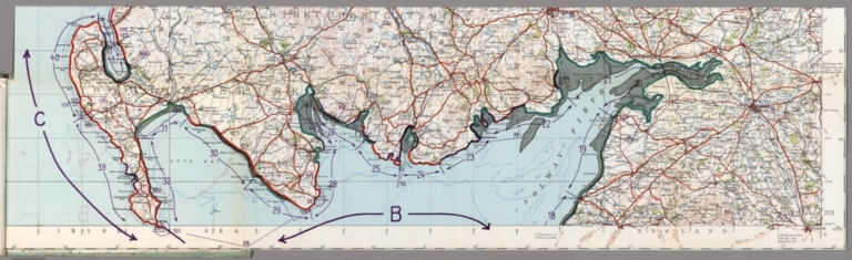
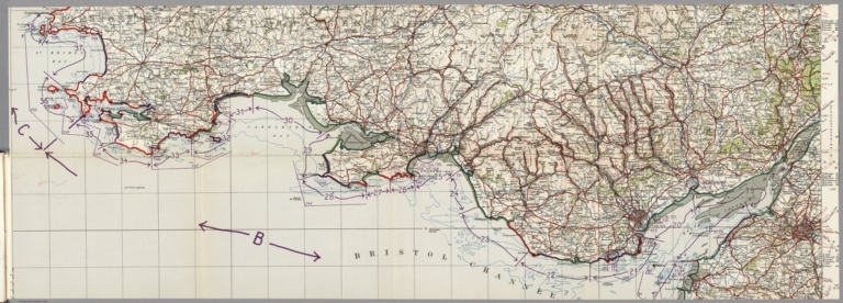
(Shoreline Type (cliff, sand, steep, flat, etc.). (Index Map) (Index of Images (Numbers 2-33)).
List No
7811.267
Note
Full color.
Author
Oberkommando der Wehrmacht (OKW) (Nazi German Supreme Command of the Armed Forces)
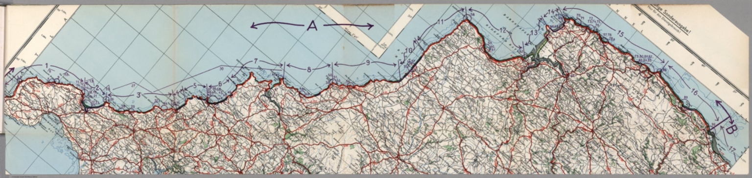
Full Title
(Shoreline Type (cliff, sand, steep, flat, etc.). (Index Map) (Index of Images (Numbers 34-82)). (inset) Isle of Man.
List No
7811.268
Note
Full color.
Author
Oberkommando der Wehrmacht (OKW) (Nazi German Supreme Command of the Armed Forces)
Full Title
(Shoreline Type (cliff, sand, steep, flat, etc.). (Index Map) (Index of Images (Numbers 83-128)).
List No
7811.269
Note
Full color.
Author
Oberkommando der Wehrmacht (OKW) (Nazi German Supreme Command of the Armed Forces)
Full Title
(Shoreline Type (cliff, sand, steep, flat, etc.). (Index Map) (Index of Images (Numbers 129-242)).
List No
7811.270
Note
Full color.
Author
Oberkommando der Wehrmacht (OKW) (Nazi German Supreme Command of the Armed Forces)
Full Title
(Shoreline Type (cliff, sand, steep, flat, etc.). (Index Map) (Index of Images (Numbers 157-250)).
List No
7811.271
Note
Full color.
Author
Oberkommando der Wehrmacht (OKW) (Nazi German Supreme Command of the Armed Forces)
Full Title
Linien gleichen mittleren Springtidenhubes. (Lines of Equal Mean Spring Tides).
List No
7811.284
Author
Oberkommando der Wehrmacht (OKW) (Nazi German Supreme Command of the Armed Forces)
Full Title
Linien gleichen mittleren Hochwasserzeitunterschiedes gegan die Zeit des Meridiandurchgangs des Mondes in Greenwich. (Lines of Equal High Water Time Difference from the Time of the Meridian High Passage of the Moon in Greenwich).
List No
7811.285
Author
Oberkommando der Wehrmacht (OKW) (Nazi German Supreme Command of the Armed Forces)
Full Title
(Shoreline Type (cliff, sand, steep, flat, etc.). (Index Map) (Index of Images (Numbers 1-90)).
List No
7811.507
Note
Full color.
Author
Oberkommando der Wehrmacht (OKW) (Nazi German Supreme Command of the Armed Forces)
Full Title
(Shoreline Type (cliff, sand, steep, flat, etc.). (Index Map) (Index of Images (Numbers 91-158)).
List No
7811.508
Note
Full color.
Author
Oberkommando der Wehrmacht (OKW) (Nazi German Supreme Command of the Armed Forces)
Full Title
(Shoreline Type (cliff, sand, steep, flat, etc.). (Index Map) (Index of Images (Numbers 159-178)).
List No
7811.509
Note
Full color.
Author
Oberkommando der Wehrmacht (OKW) (Nazi German Supreme Command of the Armed Forces)
Full Title
(Shoreline Type (cliff, sand, steep, flat, etc.). (Index Map) (Index of Images (Numbers 182-216)).
List No
7811.510
Note
Full color.
Author
Wirsing, Giselher
Full Title
Das Gefangnis der deutschen Flotte 1914/1918. (with) Deutschlands Durchbruch zum Atlantik 1940. (to accompany) Der Krieg 1939/41 in Karten.
List No
9997.024
Note
2 color maps on 2 pages.
1-41 of 41
|