|
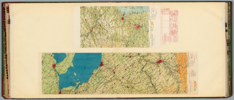
Author
Rand McNally and Company
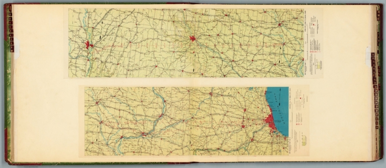
Full Title
Rand McNally standard map of Illinois. With air trails. No. 1:12S. & 7 R29. 10 N25. (to accompany) Rand McNally standard indexed and air trails maps of Illinois ... Copyright, 1930, by Rand McNally & Company, Chicago. (inset) Chicago and vicinity.
List No
11966.003
Note
Air trails map of Illinois, state and county boundaries in outline color. Shows major cities, state capital, county seats, cities, towns, airports, seaplane ports, revolving beacon lights, etc. Includes Air trails legend, compass rose and index to principal cities. Relief shown by hachures. Prime meridian is Greenwich.
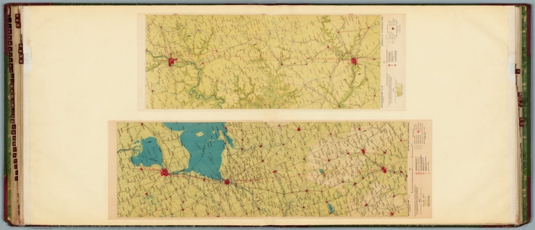
Author
Rand McNally and Company
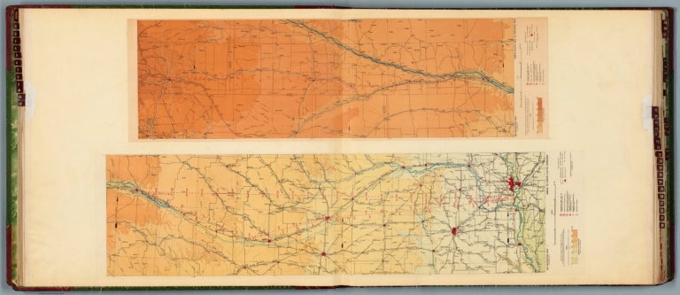
Full Title
Rand McNally standard map of Nevada. With air trails. No. 1:27S. 7 R29. (to accompany) Rand McNally standard indexed and air trails maps of Nevada ... Copyright, 1930, by Rand McNally & Company, Chicago.
List No
11981.003
Note
Air trails map of Nevada, state and county boundaries in outline color. Shows major cities, state capital, county seats, cities, towns, airports, seaplane ports, revolving beacon lights, etc. Includes Air trails legend, wind rose and index to principal cities. Prime meridian is Greenwich. Relief shown by hachures.
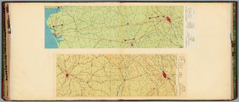
Author
Rand McNally and Company
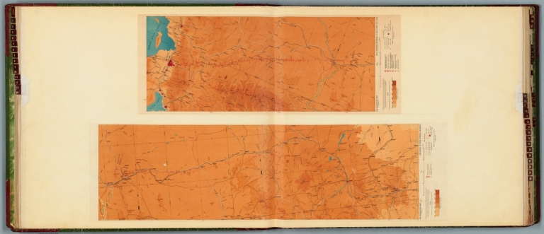
Full Title
Rand McNally standard map of New York. With air trails. No. 1:31SS. 7 R29. (to accompany) Rand McNally standard indexed and air trails maps of New York ... Copyright, 1930, by Rand McNally & Company, Chicago. (insets) Northern portion of New York on same scale. (with) Long Island extension.
List No
11985.003
Note
Air trails map of New York, state and county boundaries in outline color. Shows major cities, state capital, county seats, cities, towns, airports, seaplane ports, revolving beacon lights, etc. Includes Air trails legend, wind rose and index to principal cities. Prime meridian is Greenwich. Relief shown by hachures.
Author
News Map of the Week, Inc.
Full Title
World News of the Week : Monday, Apr. 24, 1944. Covering period Apr. 14 to Apr. 20. Volume 6, No. 34. Published and copyrighted (weekly), 1944, by News Map of the Week, Inc., 1512 Orleans Street, Chicago, Illinois. Published in two sections : Section one. Lithographed in U. S. A.
List No
14168.000
Note
Lithographed world map, in color. Shows political boundaries and military events of World War II, from April 14 to 20, 1944. Relief illustrated with hachures. Descriptive text throughout, e.g.: Where tornado struck. Map indexed according to historical notes beneath map. Features photographs, illustrations, and international time zones. With three inset maps: (Japanese advance in India) -- The size of the United States -- The Army's global airways. Map is 56 x 115 cm, on sheet 89 x 120 cm, folded to 31 x 23 cm.
Author
Gyro Air Lines, Inc.
Full Title
(Covers to) Proposed Gyro Air Line routes and schedules : Gyro Air Lines Inc. Denver.
List No
14503.001
Note
Covers to Proposed Gyro Air Line routes and schedules. Front cover includes title and an illustration of a plane over Denver Municipal Airport. Verso includes explanatory text, with title: Gyro Air Lines : General Information : Proposed complete air passenger and express service. Printed in color.
Author
Gyro Air Lines, Inc.
Full Title
The Flying-wing type, stream-lined Gyro plane is an outstanding development in aeronautics : Greatly reduced air and passenger rates will increase all kinds of transportation for Gyro Air Lines, Inc. By the Clayson Map Co. Denver, Colo.
List No
14503.003
Note
Aeronautical chart representing the United States. Shows air routes, political borders, cities, bodies of water, and coastlines. Includes a bar scale, given in miles. With descriptive text. Left side of sheet continues the flight schedule from previous page. Color lithograph. Chart is 18 x 29 cm, on fold out sheet, 24 x 41 cm.
Author
Gyro Air Lines, Inc.
Full Title
(Text Page to) Gyro Air Lines, Inc. : Class "A" stock.
List No
14503.005
Note
Certificate showing shares owned by Jos. A. Cooper of Gyro Air Lines, Inc.: Exactly fifty shares. With statement of ownership, as well as embossed seal of Gyro Air Lines. Printed in black and red with decorative border.
Author
Gyro Air Lines, Inc.
Full Title
(Text Page to) Gyro Air Lines, Inc. Gyro certificate for 50 preffered class "A" shares issued to Jos. A . Cooper, dated May 2, 1934. Gyro Air Lines, Inc. General offices, Denham Bldg., Denver, Colorado.
List No
14503.006
Note
Verso of certificate showing shares owned by Jos. A. Cooper of Gyro Air Lines, Inc. With statement of ownership, as well as embossed seal of Gyro Air Lines. Printed in black.
Author
USCOMM-ESSA-DC
Full Title
New York Metroplex (Part of FAA Air Traffic Control System - April, 1970)
List No
15901.001
Author
[Ford Motor Company, United States. Department of Commerce. Aeronautics Branch]
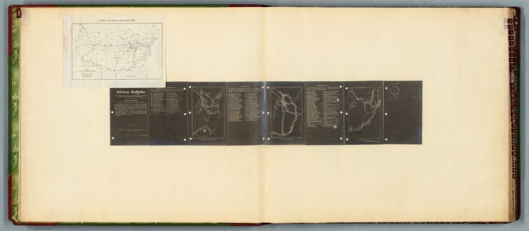
Full Title
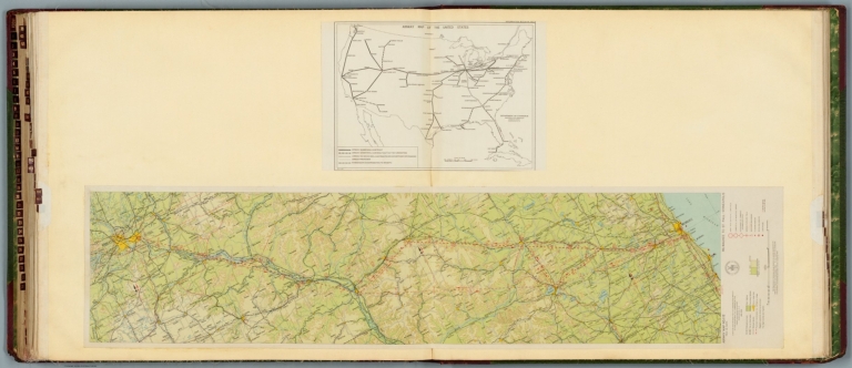
Commerce and Army Air Corps airway maps : Department of Commerce maps -- Air Corps maps -- Hydrographic Office. Airway bulletin. No. 11a, August 26, 1927. Published in Information Division, Aeronautics Branch, Department of Commerce, Washington, D.C. U.S. Government Printing Office : 1927.
List No
14501.002
Note
Four aeronautical charts of the United States. Charts feature airway strips. Charts also show political boundaries, cities with airports, bodies of water and coastlines. The first chart (printed on a white plate) is an index to the following three charts (printed in white on a black plate). The index chart includes a legend and bar scale given in miles. The following three charts each pertain to different departments - the Department of Commerce, Air Corps and Hydrographic Office - and each chart has a list of available maps, which are identifiable through the index map. Both plates are pasted to a double sheet. Together, maps are 37 x 99 cm, on double sheet, 60 x 136 cm.
Author
[Ford Motor Company, United States. Army. Air Corps, Geological Survey (U.S.). Topographic Branch]
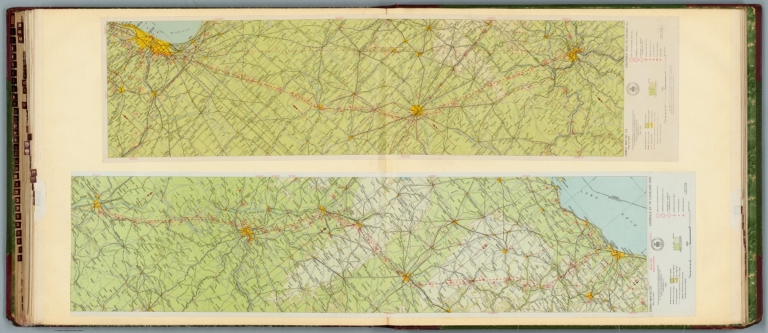
Full Title
Air navigation map no. 1 (experimental) : Dayton, Ohio to Uniontown, Pa. Compiled and reproduced by the Engineer Reproduction Plant, Corps of Engineers. Under the direction of the Airways Section, Office Chief of Air Corps. 1926, Engineer Reproduction Plant, U.S. Army, Washington Barracks, D.C. 6833. R-1927. -- Air navigation map no. 2 : Washington D.C. to Uniontown, Pa. Prepared under the direction of the Airways Section, Office of the Chief of Air Corps by the Topographic Branch, U.S. Geological Survey, 1923. Revised by Engineer Reproduction Plant, U.S. Army, 1927. Engineer Reproduction Plant, U.S. Army, Washington, D.C. 6919. 1927.
List No
14501.003
Note
Two aeronautical charts representing the areas from Dayton, Ohio, to Uniontown, Pennsylvania, and from Washington D.C., to Uniontown, Pennsylvania and Wheeling, West Virginia. Features military, municipal, commercial, emergency, and seaplane landing fields. Also shows political boundaries, roads, railways, cities, towns, topography, bodies of water, and drainage. Relief shown with contour lines and color coding. Maps include latitudinal and longitudinal lines, legend, scale statements, and bar scales given in miles, as well as compass roses oriented toward top of sheet (with slight variation between the two maps). Color lithographs. Together, maps are 56 x 103 cm, on double sheet, 60 x 136 cm.
Author
[Ford Motor Company, Geological Survey (U.S.). Topographic Branch]
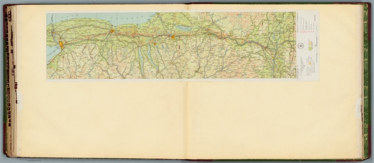
Full Title
Air navigation map no. 3 (experimental) : Washington D.C. to New York, N.Y. Prepared under the direction of the Airways Section Office of the Chief of Air Service by the Topographic Branch, U.S. Geological Survey, 1923. Engineer Reproduction Plant, U.S. Army, Washington Barracks, D.C. 4915. 1923 - reprint 1926 - R-1927. -- Air navigation map [4] (experimental) : Washington D.C. to Hampton, Va. Prepared under the direction of the Airways Section, Office of the Chief of Air Corps by the Topographic Branch, U.S. Geological Survey, 1923. Engineer Reproduction Plant, U.S. Army, Washington Barracks, D.C. 6520. 1926.
List No
14501.004
Note
Two aeronautical charts representing the areas from Washington D.C., to New York, New York, and from Washington D.C. to Hampton, Virginia. Features military, municipal, commercial, emergency, and seaplane landing fields, as well as beacon lights. Also shows political boundaries, roads, railways, cities, towns, topography, bodies of water, and drainage. Relief shown with contour lines and color coding. Maps include latitudinal and longitudinal lines, legend, scale statements, and bar scales given in miles, as well as compass roses oriented toward top of sheet (with slight variation between the two maps). Color lithographs. Together, maps are 57 x 94 cm, on double sheet, 60 x 136 cm. Map number 4 provided with a handwritten annotation.
Author
[Ford Motor Company, Geological Survey (U.S.). Topographic Branch]
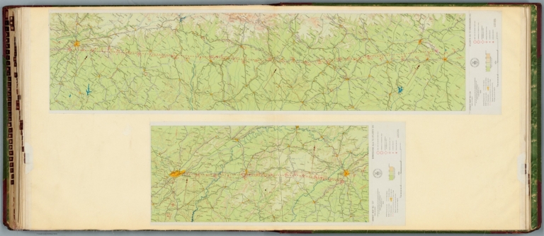
Full Title
Air navigation map [5] (experimental) : Dayton, Ohio to Rantoul, Ill. Prepared under the direction of the Airways Section Office of the Chief of Air Service by the Topographic Branch, U.S. Geological Survey, 1924. Engineer Reproduction Plant, U.S. Army, Washington Barracks, D.C. 1926, 4915-5. -- Air navigation map no. 6 (experimental) : New York, N.Y. to Boston, Mass. Prepared under the direction of the Airways Section Office of the Chief of Air Corps by the Topographic Branch, U.S. Geological Survey, 1924. Engineer Reproduction Plant, U.S. Army, Washington Barracks, D.C. 4915-6, 1924 - R-1927.
List No
14501.005
Note
Two aeronautical charts representing the areas from Dayton, Ohio to Rantoul, Illinois, and from New York, New York, to Boston, Massachusetts. Features military, municipal, commercial, emergency, and seaplane landing fields, as well as beacon lights. Also shows political boundaries, roads, railways, cities, towns, topography, bodies of water, and drainage. Relief shown with contour lines and color coding. Maps include latitudinal and longitudinal lines, legend, scale statements, and bar scales given in miles, as well as compass roses oriented toward top of sheet (with slight variation between the two maps). Color lithographs. Together, maps are 56 x 92 cm, on double sheet, 60 x 136 cm. Map number 5 provided with a handwritten annotation.
Author
[Ford Motor Company, Geological Survey (U.S.). Topographic Branch]
Full Title
Air navigation map no. 7 (experimental) : New Orleans, La. to Beaumont, Texas. Prepared under the direction of the Airways Section Office of the Chief of Air Corps. By the Topographic Branch, U.S. Geological Survey, revised to July 15, 1927. Engineer Reproduction Plant, U.S. Army, Washington Barracks, D.C. 4915. 1924 - R1927. -- Air navigation map no. 8 (experimental) : New Orleans, La. to Montgomery, Ala. Prepared under the direction of the Airways Section Office of the Chief of Air Corps by the Topographic Branch, U.S. Geological Survey, 1924. Engineer Reproduction Plant, U.S. Army, Washington Barracks, D.C. 4915-8, 1924 - R1927.
List No
14501.006
Note
Two aeronautical charts representing the areas from New Orleans, Louisiana, to Beaumont, Texas, and from New Orleans to Montgomery, Alabama. Features military, municipal, commercial, emergency, and seaplane landing fields. Also shows political boundaries, roads, railways, cities, towns, topography, bodies of water, and drainage. Relief shown with contour lines and color coding. Maps include latitudinal and longitudinal lines, legend, scale statements, and bar scales given in miles, as well as compass roses oriented toward top of sheet (with slight variation between the two maps). Color lithographs. Together, maps are 57 x 114 cm, on double sheet, 60 x 136 cm.
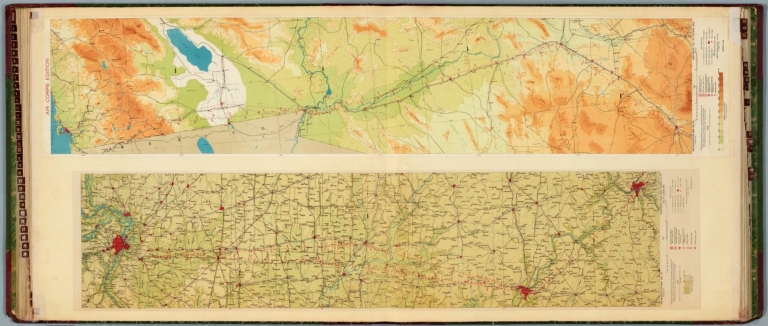
Author
[Ford Motor Company, United States. Army. Air Corps, Geological Survey (U.S.). Topographic Branch]
Full Title
Air navigation map no. 9 (experimental) : Chicago, Ill. to Iowa City, Iowa. Compiled and reproduced by the Engineer Reproduction Plant, Corps of Engineers. Under the direction of the Airways Section, Office Chief of Air Corps. 1924. Engineer Reproduction Plant, U.S. Army, Washington Barracks, D.C. 4915. 1924. -- Air navigation map [10] (experimental) : Iowa City, Iowa to Omaha, Nebr. Prepared under the direction of the Airways Section Office of the Chief of Air Service by the Topographic Branch, U.S. Geological Survey, 1924. Engineer Reproduction Plant, U.S. Army, Washington Barracks, D.C. 4915-10. 1924.
List No
14501.007
Note
Two aeronautical charts representing the areas from Chicago, Illinois, to Iowa City, Iowa, and from Iowa City, Iowa, to Omaha, Nebraska. Features military, municipal, commercial, emergency, and seaplane landing fields. Also shows political boundaries, roads, railways, cities, towns, topography, bodies of water, and drainage. Relief shown with contour lines and color coding. Maps include latitudinal and longitudinal lines, legend, scale statements, and bar scales given in miles, as well as compass roses oriented toward top of sheet (with slight variation between the two maps). Color lithographs. Together, maps are 57 x 96 cm on double sheet, 60 x 136 cm. Map number 10 provided with a handwritten annotation.
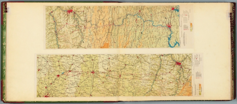
Author
[Ford Motor Company, Geological Survey (U.S.). Topographic Branch, United States. War Department. Office of the Chief of Air Service]
Full Title
Air navigation map [11] (experimental) : Omaha to North Platte, Nebraska. Prepared under the direction of the Airways Section of the Chief of Air Service by the Topographic Branch, U.S. Geological Survey. 1925. Engineer Reproduction Plant, U.S. Army, Washington Barracks, D.C. 6068-11. 1925. -- Air navigation map [12] (experimental) : North Platte, Neb. to Cheyenne, Wyo. Compiled and reproduced by the Engineer Reproduction Plant, Corps of Engineers. Under the direction of the Airways Section, Office Chief of Air Service. 1925. Engineer Reproduction Plant, U.S. Army, Washington Barracks, D.C.
List No
14501.008
Note
Two aeronautical charts representing the areas from Omaha, Nebraska, to North Platte, Nebraska, and from North Platte, Nebraska, to Cheyenne, Wyoming. Features military, mail, municipal, commercial, emergency, and seaplane landing fields. Also shows political boundaries, roads, railways, cities, towns, topography, bodies of water, and drainage. Relief shown with contour lines and color coding. Maps include latitudinal and longitudinal lines, legend, scale statements, and bar scales given in miles, as well as compass roses oriented toward top of sheet (with slight variation between the two maps). Color lithographs. Together, maps are 56 x 102 cm, on double sheet, 60 x 136 cm. Map numbers 11 and 12 provided with handwritten annotations.
Author
[Ford Motor Company, United States. War Department. Office of the Chief of Air Service]
Full Title
Air navigation map [13] (experimental) : Cheyenne to Rock Springs, Wyoming. Compiled and reproduced by the Engineer Reproduction Plant, Corps of Engineers. Under the direction of the Airways Section, Office Chief of Air Service. 1925. Engineer Reproduction Plant, U.S. Army, Washington Barracks, D.C. 4915-13. -- Air navigation map [14] (experimental) : Rock Springs, Wyoming to Salt Lake City, Utah. Compiled and reproduced by the Engineer Reproduction Plant, Corps of Engineers. Under the direction of the Airways Section, Office Chief of Air Service. 1925. Engineer Reproduction Plant, U.S. Army, Washington Barracks, D.C. 4915-14.
List No
14501.009
Note
Two aeronautical charts representing the areas from Cheyenne to Rock Springs, Wyoming, and from Rock Springs, Wyoming, to Salt Lake City, Utah. Features military, mail, municipal, commercial, emergency, and seaplane landing fields. Also shows political boundaries, roads, railways, cities, towns, topography, bodies of water, shorelines, and drainage. Relief shown with contour lines and color coding. Maps include latitudinal and longitudinal lines, legend, scale statements, and bar scales given in miles, as well as compass roses oriented toward top of sheet (with slight variation between the two maps). Color lithographs. Together, maps are 56 x 93 cm, on double sheet, 60 x 136 cm. Map numbers 13 and 14 provided with handwritten annotations.
Author
[Ford Motor Company, Geological Survey (U.S.). Topographic Branch, United States. Army. Air Corps]
Full Title
Air navigation map no. 15 (experimental) : Montgomery, Alabama to Augusta, Georgia. Prepared under the direction of the Airways Section Office of the Chief of Air Corps by the Topographic Branch, U.S. Geological Survey. 1926. Engineer Reproduction Plant, U.S. Army, Washington Barracks, D.C. 6572-15. 1926. -- Air navigation map no. 16 (experimental) : Augusta, GA. to Fayetteville, N.C. Compiled and reproduced by the Engineer Reproduction Plant, Corps of Engineers. Under the direction of the Airways Section, Office Chief of Air Corps. 1926. Engineer Reproduction Plant, U.S. Army, Washington Barracks, D.C. 4915. R-1927.
List No
14501.010
Note
Two aeronautical charts representing the areas from Montgomery, Alabama, to Augusta, Georgia, and from Augusta, Georgia, to Fayetteville, North Carolina. Features military, municipal, commercial, emergency, and seaplane landing fields. Also shows political boundaries, roads, railways, cities, towns, topography, bodies of water, shorelines, and drainage. Relief shown with contour lines and color coding. Maps include latitudinal and longitudinal lines, legend, scale statements, and bar scales given in miles, as well as compass roses oriented toward top of sheet (with slight variation between the two maps). Color lithographs. Together, maps are 57 x 102 cm, on double sheet, 60 x 136 cm.
Author
[Ford Motor Company, United States. War Department. Office of the Chief of Air Service]
Full Title
Air navigation map [18] (experimental) : Fayetteville, N.C. to Norfolk, Va. Compiled and reproduced by the Engineer Reproduction Plant, Corps of Engineers. Under the direction of the Airways Section, Office Chief of Air Service. 1925. Engineer Reproduction Plant, U.S. Army, Washington Barracks, D.C. 5737-18.
List No
14501.011
Note
Aeronautical chart representing the areas from Fayetteville, North Carolina, to Norfolk, Virginia. Features military, mail, municipal, commercial, emergency, and seaplane landing fields. Also shows political boundaries, roads, railways, cities, towns, topography, bodies of water, shorelines, and drainage. Relief shown with contour lines and color coding. Map includes latitudinal and longitudinal lines, legend, scale statement, and bar scale given in miles, as well as a compass rose oriented toward top of sheet. Color lithograph. Map is 26 x 86 cm, on double sheet, 60 x 136 cm. Map number 18 provided with a handwritten annotation.
Author
[Ford Motor Company, United States. Army. Air Corps]
Full Title
Air navigation map no. 19 (experimental) : New York, N.Y. to Bellefonte, Pa. Compiled and reproduced by the Engineer Reproduction Plant, Corps of Engineers. Under the direction of the Airways Section, Office Chief of Air Corps. 1923. Engineer Reproduction Plant, U.S. Army, Washington Barracks, D.C. 4915. 1923-R1928.
List No
14501.012
Note
Aeronautical chart representing the areas from New York, New York, to Bellefonte, Pennsylvania. Features military, mail, municipal, commercial, emergency, and seaplane landing fields, with beacon lights. Also shows political boundaries, roads, railways, cities, towns, topography, bodies of water, coastlines, and drainage. Relief shown with contour lines and color coding. Map includes latitudinal and longitudinal lines, legend, scale statement, and bar scale given in miles, as well as a compass rose oriented toward top of sheet. Color lithograph. Map is 27 x 90 cm, on double sheet, 60 x 136 cm.
Author
[Ford Motor Company, United States. Army. Air Corps]
Full Title
Air navigation map [20] (experimental) : Bellefonte, Pa. to Cleveland, Ohio. Compiled and reproduced by the Engineer Reproduction Plant, Corps of Engineers. Under the direction of the Airways Section, Office Chief of Air Service. 1923. Engineer Reproduction Plant, U.S. Army, Washington Barracks, D.C. 1926. 4915 20.
List No
14501.013
Note
Aeronautical chart representing the areas from Bellefonte, Pennsylvania, to Cleveland, Ohio. Features military, mail, municipal, commercial, emergency, and seaplane landing fields. Also shows political boundaries, roads, railways, cities, towns, topography, bodies of water, shoreline, and drainage. Relief shown with contour lines and color coding. Map includes latitudinal and longitudinal lines, legend, scale statement, and bar scale given in miles, as well as a compass rose oriented toward top of sheet. Color lithograph. Map is 27 x 87 cm, on double sheet, 60 x 136 cm. Map number 20 provided with a handwritten annotation.
Author
[Ford Motor Company, United States. War Department. Office of the Chief of Air Service]
Full Title
Air navigation map [21] (experimental) : Cleveland, Ohio to Chicago, Ill. Compiled and reproduced by the Engineer Reproduction Plant, Corps of Engineers. Under the direction of the Airways Section, Office Chief of Air Service. 1923. Engineer Reproduction Plant, U.S. Army, Washington Barracks, D.C. 1926. 4915-21. -- Air navigation map [22] (experimental) : Chicago, Ill. to St. Louis, Mo. Compiled and reproduced by the Engineer Reproduction Plant, Corps of Engineers. Under the direction of the Airways Section, Office Chief of Air Service. 1923. Engineer Reproduction Plant, U.S. Army, Washington Barracks, D.C. 1926. 4915-22.
List No
14501.014
Note
Two aeronautical charts representing the areas from Cleveland, Ohio, to Chicago, Illinois, and from Chicago, Illinois, to St. Louis, Missouri. Features military, municipal, commercial, emergency, and seaplane landing fields. Also shows political boundaries, roads, railways, cities, towns, topography, bodies of water, shorelines, and drainage. Relief shown with contour lines and color coding. Maps include latitudinal and longitudinal lines, legend, scale statements, and bar scales given in miles, as well as compass roses oriented toward top of sheet (with slight variation between the two maps). Color lithographs. Together, maps are 56 x 120 cm, on double sheet, 60 x 136 cm. Map numbers 21 and 22 provided with handwritten annotations.
Author
[Ford Motor Company, United States. Army. Air Corps, United States. War Department. Office of the Chief of Air Service]
Full Title
Air navigation map no. 23 (experimental) : Saint Louis to Kansas City, Mo. Compiled and reproduced by the Engineer Reproduction Plant, Corps of Engineers. Under the direction of the Airways Section, Office Chief of Air Corps. 1923. Engineer Reproduction Plant, U.S. Army, Washington Barracks, D.C. 4915. 1926. R1927. -- Air navigation map [24] (experimental) : Kansas City, Mo. to Muskogee, Okla. Compiled and reproduced by the Engineer Reproduction Plant, Corps of Engineers. Under the direction of the Airways Section, Office Chief of Air Service. 1923. Engineer Reproduction Plant, U.S. Army, Washington Barracks, D.C. 1924. 4915-24.
List No
14501.015
Note
Two aeronautical charts representing the areas from Saint Louis to Kansas City, Missouri, and from Kansas City, Missouri, to Muskogee, Oklahoma. Features military, municipal, commercial, emergency, and seaplane landing fields, as well as beacon lights. Also shows political boundaries, roads, railways, cities, towns, topography, bodies of water, shorelines, and drainage. Relief shown with contour lines and color coding. Maps include latitudinal and longitudinal lines, legend, scale statements, and bar scales given in miles, as well as compass roses oriented toward top of sheet (with slight variation between the two maps). aeronautical chart 24 includes eight inset maps showing route and landing facilities. Color lithographs. Together, maps are 56 x 120 cm, on double sheet, 60 x 136 cm. Map number 24 provided with a handwritten annotation.
Author
[Ford Motor Company, United States. War Department. Office of the Chief of Air Service]
Full Title
Air navigation map [25] (experimental) : Muskogee, Oklahoma to Ft. Worth and Dallas, Texas. Compiled and reproduced by the Engineer Reproduction Plant, Corps of Engineers. Under the direction of the Airways Section, Office Chief of Air Service. 1924. Engineer Reproduction Plant, U.S. Army, Washington Barracks, D.C. 1926. 4915-25. -- Air navigation map [26] (experimental) : Dallas and Ft. Worth to San Antonio, Texas. Compiled and reproduced by the Engineer Reproduction Plant, Corps of Engineers. Under the direction of the Airways Section, Office Chief of Air Service. 1923. Engineer Reproduction Plant, U.S. Army, Washington Barracks, D.C. 4915-25. 1924.
List No
14501.016
Note
Two aeronautical charts representing the areas from Muskogee, Oklahoma, to Ft. Worth and Dallas, Texas, and from Dallas and Fort Worth to San Antonio, Texas. Features military, municipal, commercial, emergency, and seaplane landing fields. Also shows political boundaries, roads, railways, cities, towns, topography, bodies of water, and drainage. Relief shown with contour lines and color coding. Maps include latitudinal and longitudinal lines, legend, scale statements, and bar scales given in miles, as well as compass roses oriented toward top of sheet (with slight variation between the two maps). Color lithographs. Together, maps are 56 x 102 cm, on double sheet, 60 x 136 cm. Map numbers 25 and 26 provided with handwritten annotations.
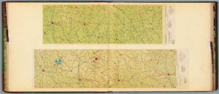
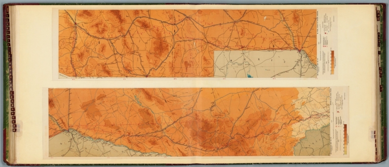
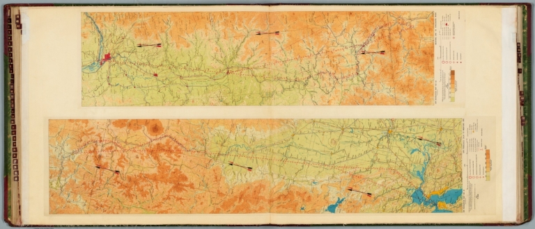
Author
[Ford Motor Company, United States. Army. Air Corps, United States. War Department. Office of the Chief of Air Service]
Full Title
Air navigation map no. 27 (experimental) : Beaumont to San Antonio, Texas. Compiled and reproduced by the Engineer Reproduction Plant, Corps of Engineers. Under the direction of the Airways Section, Office Chief of Air Corps. 1923. Engineer Reproduction Plant, U.S. Army, Washington Barracks, D.C. 4915. 1923 - R1927. -- Air navigation map [28] (experimental) : San Antonio to Dryden, Texas. Compiled and reproduced by the Engineer Reproduction Plant, Corps of Engineers. Under the direction of the Airways Section, Office Chief of Air Service. 1924. Engineer Reproduction Plant, U.S. Army, Washington Barracks, D.C. 1924. 4915.
List No
14501.017
Note
Two aeronautical charts representing the areas from Beaumont to San Antonio, Texas, and from San Antonio to Dryden, Texas. Features military, municipal, commercial, emergency, and seaplane landing fields. Also shows political boundaries, roads, railways, cities, towns, topography, bodies of water, drainage, and coastlines. Relief shown with contour lines and color coding. Maps include latitudinal and longitudinal lines, legend, scale statements, and bar scales given in miles, as well as compass roses oriented toward top of sheet (with slight variation between the two maps). Color lithographs. Together, maps are 56 x 110 cm, on double sheet, 60 x 136 cm. Map number 28 provided with a handwritten annotation.
Author
[Ford Motor Company, United States. Army. Air Corps]
Full Title
Air navigation map no. 29 (experimental) : Dryden to El Paso, Texas. Compiled and reproduced by the Engineer Reproduction Plant, Corps of Engineers. Under the direction of the Airways Section, Office Chief of Air Corps. 1924. Engineer Reproduction Plant, U.S. Army, Washington Barracks, D.C. 4915. 1924 -- Air navigation map no. 30 (experimental) : El Paso, Texas to Tucson, Arizona. Compiled and reproduced by the Engineer Reproduction Plant, Corps of Engineers. Under the direction of the Airways Section, Office Chief of Air Corps. 1924. Engineer Reproduction Plant, U.S. Army, Washington Barracks, D.C. 4915-30. 1924 R1927.
List No
14501.018
Note
Two aeronautical charts representing the areas from Dryden to El Paso, Texas, and from El Paso, Texas, to Tucson, Arizona. Features military, municipal, commercial, emergency, and seaplane landing fields. Also shows political boundaries, roads, railways, cities, towns, topography, bodies of water, and drainage. Relief shown with contour lines and color coding. Maps include latitudinal and longitudinal lines, legend, scale statements, and bar scales given in miles, as well as compass roses oriented toward top of sheet (with slight variation between the two maps). Color lithographs. Together, maps are 57 x 113 cm, on double sheet, 60 x 136 cm.
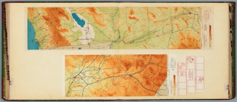
Author
[Ford Motor Company, United States. War Department. Office of the Chief of Air Service, United States. Army. Air Corps]
Full Title
Air navigation map [31] (experimental) : Nogales and Tucson to Phoenix, Arizona. Compiled and reproduced by the Engineer Reproduction Plant, Corps of Engineers. Under the direction of the Airways Section, Office Chief of Air Service. 1924. -- Air navigation map no. 32 (experimental) : Phoenix, Arizona to San Diego, Calif.. Compiled and reproduced by the Engineer Reproduction Plant, Corps of Engineers. Under the direction of the Airways Section, Office Chief of Air Corps. 1924. Engineer Reproduction Plant, U.S. Army, Washington Barracks, D.C. 4915-30. 1924 - R1927.
List No
14501.019
Note
Two aeronautical charts representing the areas from Nogales and Tucson to Phoenix, Arizona, and from Phoenix, Arizona, to San Diego, California. Features military, municipal, commercial, emergency, and seaplane landing fields. Also shows political boundaries, roads, railways, cities, towns, topography, bodies of water, drainage, and coastlines. Relief shown with contour lines and color coding. Maps include latitudinal and longitudinal lines, legend, scale statements, and bar scales given in miles, as well as compass roses oriented toward top of sheet (with slight variation between the two maps). aeronautical chart 31 includes four inset maps showing route and landing facilities. Color lithographs. Together, maps are 56 x 115 cm, on double sheet, 60 x 135 cm. Map number 31 provided with a handwritten annotation.
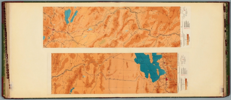
Author
[Ford Motor Company, United States. War Department. Office of the Chief of Air Service, United States. Army. Air Corps]
Full Title
Air navigation map [33] (experimental) : Salt Lake City, Utah to Elko, Nev. Compiled and reproduced by the Engineer Reproduction Plant, Corps of Engineers. Under the direction of the Airways Section, Office Chief of Air Service. 1924. Engineer Reproduction Plant, U.S. Army, Washington Barracks, D.C. 1926. 4915-33. -- Air navigation map [34] (experimental) : Elko to Reno, Nev. Compiled and reproduced by the Engineer Reproduction Plant, Corps of Engineers. Under the direction of the Airways Section, Office Chief of Air Corps. 1924. Engineer Reproduction Plant, U.S. Army, Washington Barracks, D.C. 4915-34.
List No
14501.020
Note
Two aeronautical charts representing the areas from Salt Lake City, Utah, to Elko, Nevada, and from Elko to Reno, Nevada. Features military, municipal, commercial, emergency, and seaplane landing fields. Also shows political boundaries, roads, railways, cities, towns, topography, bodies of water, drainage, and shorelines. Relief shown with contour lines and color coding. Maps include latitudinal and longitudinal lines, legend, scale statements, and bar scales given in miles, as well as compass roses oriented toward top of sheet (with slight variation between the two maps). aeronautical chart 31 includes four inset maps showing route and landing facilities. Color lithographs. Together, maps are 56 x 93 cm, on double sheet, 60 x 135 cm. Map numbers 33 and 34 provided with handwritten annotations.
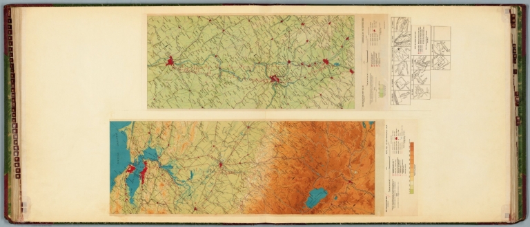
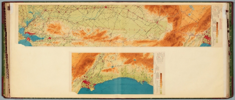
Author
[Ford Motor Company, United States. War Department. Office of the Chief of Air Service, United States. Army. Air Corps]
Full Title
Air navigation map [35] (experimental) : Reno, Nev. to San Francisco, Calif. Compiled and reproduced by the Engineer Reproduction Plant, Corps of Engineers. Under the direction of the Airways Section, Office Chief of Air Service. 1924. Engineer Reproduction Plant, U.S. Army, Washington Barracks, D.C. 4915-35. 1926. -- Air navigation map no. 36 (experimental) : Louisville, Ky. to Dayton, Ohio. Compiled and reproduced by the Engineer Reproduction Plant, Corps of Engineers. Under the direction of the Airways Section, Office Chief of Air Corps. 1925. Engineer Reproduction Plant, U.S. Army, Washington Barracks, D.C. 4915. R-1928.
List No
14501.021
Note
Two aeronautical charts representing the areas from Reno, Nevada, to San Francisco, California, and from Louisville, Kentucky, to Dayton, Ohio. Features military, municipal, commercial, emergency, and seaplane landing fields. Also shows political boundaries, roads, railways, cities, towns, topography, bodies of water, drainage, and coastlines. Relief shown with contour lines and color coding. Maps include latitudinal and longitudinal lines, legend, scale statements, and bar scales given in miles, as well as compass roses oriented toward top of sheet (with slight variation between the two maps). aeronautical chart no. 36 includes eleven inset maps showing route and landing facilities. Color lithographs. Together, maps are 56 x 85 cm, on double sheet, 60 x 135 cm. Map number 35 provided with a handwritten annotation.
Author
[Ford Motor Company, United States. Army. Air Corps]
Full Title
Air navigation map no. 37 (experimental) : Cincinatti, Ohio and Louisville, Ky. to St. Louis, Mo. Compiled and reproduced by the Engineer Reproduction Plant, Corps of Engineers. Under the direction of the Airways Section, Office Chief of Air Corps. 1925. Engineer Reproduction Plant, U.S. Army, Washington Barracks, D.C. 4915. 1926 - R1927. -- Air Corps Edition : Air navigation map no. 38 (experimental) : San Diego, Cal. to Tucson, Ariz. Compiled and reproduced by the Engineer Reproduction Plant, Corps of Engineers. Under the direction of the Airways Section, Office Chief of Air Corps. 1926. Engineer Reproduction Plant, U.S. Army, Washington Barracks, D.C. 6695.
List No
14501.022
Note
Two aeronautical charts representing the areas from Cincinnati, Ohio, and Louisville, Kentucky. to Saint Louis, Missouri, and from San Diego, California, to Tucson, Arizona. Features military, municipal, commercial, emergency, and seaplane landing fields, as well as beacon lights. Also shows political boundaries, roads, railways, cities, towns, topography, bodies of water, drainage, and coastlines. Relief shown with contour lines and color coding. Maps include latitudinal and longitudinal lines, legend, scale statements, and bar scales given in miles, as well as compass roses oriented toward top of sheet (with slight variation between the two maps). Color lithographs. Together, maps are 56 x 130 cm, on double sheet, 60 x 135 cm.
Author
[Ford Motor Company, United States. Army. Air Corps]
Full Title
Air navigation map no. 39 (experimental) : San Diego to Los Angeles, Cal. Compiled and reproduced by the Engineer Reproduction Plant, Corps of Engineers. Under the direction of the Airways Section, Office Chief of Air Corps. 1925. Engineer Reproduction Plant, U.S. Army, Washington Barracks, D.C. 6762-39. R1927. -- Air navigation map no. 40 (experimental) : San Francisco to Los Angeles, Cal. Compiled and reproduced by the Engineer Reproduction Plant, Corps of Engineers. Under the direction of the Airways Section, Office Chief of Air Corps. 1926. Engineer Reproduction Plant, U.S. Army, Washington Barracks.
List No
14501.023
Note
Two aeronautical charts representing the areas from San Diego to Los Angeles, California, and from San Francisco to Los Angeles, California. Features military, municipal, commercial, emergency, and seaplane landing fields, as well as beacon lights. Also shows political boundaries, roads, railways, cities, towns, topography, bodies of water, drainage, and coastlines. Relief shown with contour lines and color coding. Maps include latitudinal and longitudinal lines, legend, scale statements, and bar scales given in miles, as well as compass roses oriented toward top of sheet (with slight variation between the two maps). Color lithographs. Together, maps are 56 x 127 cm, on double sheet, 60 x 135 cm.
Author
[Ford Motor Company, United States. Army. Air Corps]
Full Title
Air navigation map no. 41 (experimental) : San Francisco, Calif. to Medford, Ore. Compiled and reproduced by the Engineer Reproduction Plant, Corps of Engineers. Under the direction of the Airways Section, Office Chief of Air Corps. 1927. Engineer Reproduction Plant, U.S. Army, Washington Barracks, D.C. 6467. 1927. R1928. -- Air navigation map no. 42 (experimental) : Medford, Ore. to Vancouver, Wash. 1927. R-1928. Compiled and reproduced by the Engineer Reproduction Plant, Corps of Engineers. Under the direction of the Airways Section, Office Chief of Air Corps. 1926. Engineer Reproduction Plant, U.S. Army, Washington Barracks. 6468.
List No
14501.024
Note
Two aeronautical charts representing the areas from San Francisco, California. to Medford, Oregon, and from Medford, Oregon, to Vancouver, Washington. Features military, municipal, commercial, emergency, and seaplane landing fields, as well as beacon lights. Also shows political boundaries, roads, railways, cities, towns, topography, bodies of water, drainage, and coastlines. Relief shown with contour lines and color coding. Maps include latitudinal and longitudinal lines, legend, scale statements, and bar scales given in miles, as well as compass roses oriented toward top of sheet (with slight variation between the two maps). Color lithographs. Together, maps are 56 x 121 cm, on double sheet, 60 x 135 cm.
Author
[Ford Motor Company, United States. Army. Air Corps]
Full Title
Air navigation map no. 43 (experimental) : Vancouver to Seattle, Washington. Compiled and reproduced by the Engineer Reproduction Plant, Corps of Engineers. Under the direction of the Airways Section, Office Chief of Air Corps. 1927. R-1928. Engineer Reproduction Plant, U.S. Army, Washington Barracks, D.C. 6470. 1927 - R-1929. -- Air navigation map [44] (experimental) : Rantoul, Ill. to Mt. Clemens, Mich. Compiled and reproduced by the Engineer Reproduction Plant, Corps of Engineers. Under the direction of the Airways Section, Office Chief of Air Service. 1925. Engineer Reproduction Plant, U.S. Army, Washington Barracks, D.C. 4915-44.
List No
14501.025
Note
Two aeronautical charts representing the areas from Vancouver to Seattle, Washington, and from Rantoul, Illinois, to Mount Clemens, Michigan. Features military, municipal, commercial, emergency, and seaplane landing fields, as well as beacon lights. Also shows political boundaries, roads, railways, cities, towns, topography, bodies of water, drainage, and coastlines. Relief shown with contour lines and color coding. Maps include latitudinal and longitudinal lines, legend, scale statements, and bar scales given in miles, as well as compass roses oriented toward left of sheet (with slight variation between the two maps). Color lithographs. Together, maps are 54 x 123 cm, on double sheet, 60 x 135 cm. Map number 44 provided with a handwritten annotation.
Author
[Ford Motor Company, United States. Army. Air Corps]
Full Title
Air navigation map no. 45 (experimental) : Uniontown, Pittsburgh, Pa. to Cleveland, O. and Mt. Clemens, Mich. Compiled and reproduced by the Engineer Reproduction Plant, Corps of Engineers. Under the direction of the Airways Section, Office Chief of Air Corps. 1925. Engineer Reproduction Plant, U.S. Army, Washington Barracks, D.C. 6158. R-1928. -- Air navigation map [46] (experimental) : Washington, D.C. to Middletown, Pa. Compiled and reproduced by the Engineer Reproduction Plant, Corps of Engineers. Under the direction of the Airways Section, Office Chief of Air Service. 1925. Engineer Reproduction Plant, U.S. Army, Washington Barracks, D.C. 4915-46.
List No
14501.026
Note
Two aeronautical charts representing the areas from Uniontown, Pittsburgh, Pennsylvania, to Cleveland, Ohio and Mount Clemens, Michigan, and from Washington, D.C., to Middletown, Pennsylvania. Features military, municipal, commercial, emergency, and seaplane landing fields. Also shows political boundaries, roads, railways, cities, towns, topography, bodies of water, drainage, and coastlines. Relief shown with contour lines and color coding. Maps include latitudinal and longitudinal lines, legend, scale statements, and bar scales given in miles, as well as compass roses oriented toward left of sheet (with slight variation between the two maps). aeronautical chart 46 includes six inset maps showing route and landing facilities. Color lithographs. Together, maps are 56 x 97 cm, on double sheet, 60 x 135 cm. Map number 46 provided with a handwritten annotation.
Author
[Ford Motor Company, United States. War Department. Office of the Chief of Air Service, United States. Army. Air Corps]
Full Title
Air navigation map [47] (experimental) : Dayton, Ohio to Mt. Clemens, Mich. Compiled and reproduced by the Engineer Reproduction Plant, Corps of Engineers. Under the direction of the Airways Section, Office Chief of Air Service. 1925. Engineer Reproduction Plant, U.S. Army, Washington Barracks, D.C. 4915-47. 1926. -- Air navigation map 48 (experimental) : Louisville, Ky. to Nashville, Tenn. Compiled and reproduced by the Engineer Reproduction Plant, Corps of Engineers. Under the direction of the Airways Section, Office Chief of Air Corps. 1927. Engineer Reproduction Plant, U.S. Army, Washington Barracks, D.C. 6275-48.
List No
14501.027
Note
Two aeronautical charts representing the areas from Dayton, Ohio, to Mount Clemens, Michigan, and from Louisville, Kentucky, to Nashville, Tennessee. Features military, municipal, commercial, emergency, and seaplane landing fields. Also shows political boundaries, roads, railways, cities, towns, topography, bodies of water, drainage, and coastlines. Relief shown with contour lines and color coding. Maps include latitudinal and longitudinal lines, legend, scale statements, and bar scales given in miles, as well as compass roses oriented toward left of sheet (with slight variation between the two maps). Color lithographs. Together, maps are 56 x 86 cm, on double sheet, 60 x 135 cm. Map number 47 provided with a handwritten annotation.
Author
[Ford Motor Company, United States. Army. Air Corps]
Full Title
Air navigation map no. 49 (experimental) : Nashville, Tenn. to Birmingham, Ala. Compiled and reproduced by the Engineer Reproduction Plant, Corps of Engineers. Under the direction of the Airways Section, Office Chief of Air Corps. 1927. Engineer Reproduction Plant, U.S. Army, Washington Barracks, D.C. 6276. -- Air navigation map no. 50 (experimental) : Birmingham, Ala. to Pensacola, Fla. Compiled and reproduced by the Engineer Reproduction Plant, Corps of Engineers. Under the direction of the Airways Section, Office Chief of Air Corps. 1927. R-1928. Engineer Reproduction Plant, U.S. Army, Washington Barracks, D.C. 6277.
List No
14501.028
Note
Two aeronautical charts representing the areas from Nashville, Tennessee, to Birmingham, Alabama, and from Birmingham to Pensacola, Florida. Features military, municipal, commercial, emergency, and seaplane landing fields. Also shows political boundaries, roads, railways, cities, towns, topography, bodies of water, drainage, and coastlines. Relief shown with contour lines and color coding. Maps include latitudinal and longitudinal lines, legend, scale statements, and bar scales given in miles, as well as compass roses oriented toward left and right of sheet, respectively. Color lithographs. Together, maps are 56 x 92 cm, on double sheet, 60 x 135 cm.
Author
[Ford Motor Company, United States. Army. Air Corps]
Full Title
Air navigation map no. 51 (experimental) : Muskogee, Okla. To Belleville, ILL. Compiled and reproduced by the Engineer Reproduction Plant, Corps of Engineers. Under the direction of the Airways Section, Office Chief of Air Corps. 1927. Engineer Reproduction Plant, U.S. Army, Washington Barracks, D.C. 6276. -- Air navigation map no. 52 (experimental) : Dayton, Ohio To Belleville ILL .. Compiled and reproduced by the Engineer Reproduction Plant, Corps of Engineers. Under the direction of the Airways Section, Office Chief of Air Corps. 1927. Engineer Reproduction Plant, U.S. Army, Washington Barracks, D.C. 6277.
List No
14501.029
Note
Two aeronautical charts representing the areas from Muskogee, Okla, to Belleville, ILL. and from Dayton, Ohio to Belleville, ILL. Features military, municipal, commercial, emergency, and seaplane landing fields. Also shows political boundaries, roads, railways, cities, towns, topography, bodies of water, drainage, and coastlines. Relief shown with contour lines and color coding. Maps include latitudinal and longitudinal lines, legend, scale statements, and bar scales given in miles, as well as compass roses oriented toward left and right of sheet, respectively. Color lithographs. Together, maps are 56 x 92 cm, on double sheet, 60 x 135 cm.
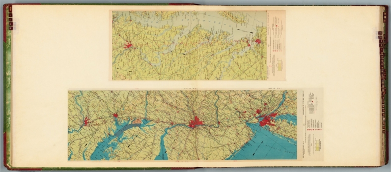
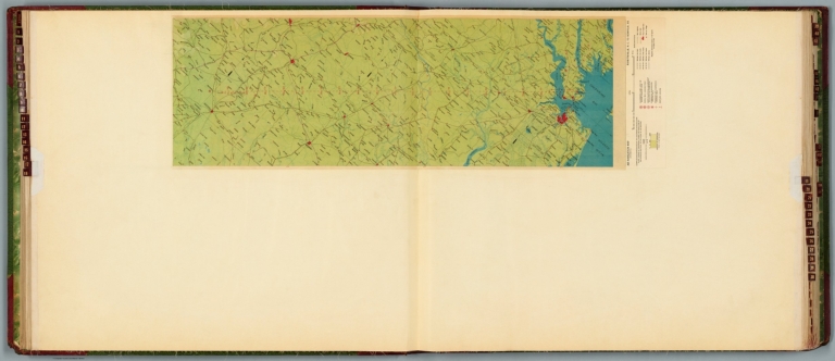
Author
[Ford Motor Company, United States. Hydrographic Office]
Full Title
U.S. Navy aviation chart : Philadelphia - Norfolk. Washington, D.C. Published Feb. 1927, at the Hydrographic Office, under the authority of the Secretary of the Navy. 1st edition, Feb. 1927.
List No
14501.030
Note
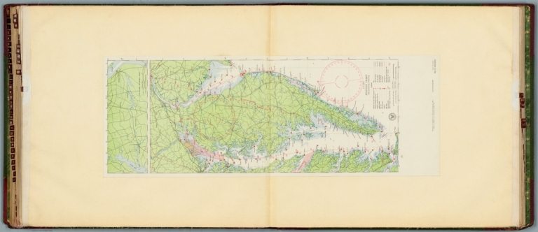
Aeronautical chart representing the areas from Philadelphia, Pennsylvania, to Norfolk, Virginia. Features military, municipal, commercial, emergency, and seaplane landing fields, as well as racetracks, coast guard stations, lighthouses, and radio stations. Also shows roads, railways, cities, towns, bodies of water, drainage, and coastlines. Map includes latitudinal and longitudinal lines, a legend, scale statement, and bar scales given in nautical miles and statute miles, as well as a compass rose oriented toward top of sheet. Includes the seal of the Hydrographic Office, U.S. Navy. With one inset map: Chesapeake - Delaware Canal. Color lithograph. Map is 90 x 32 cm, on double sheet, 136 x 60 cm.
Author
[Ford Motor Company, United States. Hydrographic Office]
Full Title
U.S. Navy aviation chart : Baltimore - Washington - Norfolk. Washington, D.C., published Dec. 1925 at the Hydrographic Office, under the authority of the Secretary of the Navy. No.V-050001. Edition : 2d, April, 1925.
List No
14501.031
Note
Aeronautical chart representing the areas from Baltimore, Maryland, to Washington, D.C. and to Norfolk, Virginia. Features landing fields and seaplane anchorage. Also shows roads, railways, cities, towns, bodies of water, drainage, and coastlines. Includes latitudinal and longitudinal lines, a legend, scale statement, and bar scales given in nautical miles and miles, as well as a compass rose oriented toward top of sheet. Surrounding the chart are black and white photographic vignettes of select lighthouses and landing fields. With seal of the Hydrographic Office, U.S. Navy. Color lithograph. Chart is 72 x 41 cm, on double sheet, 136 x 60 cm.
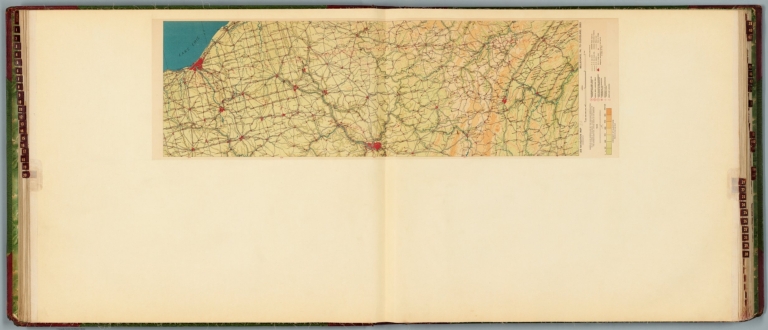
Author
[Ford Motor Company, U.S. Coast and Geodetic Survey]
Full Title
Airway map no. 102 : Dallas to Oklahoma City. Compiled and printed for the Aeronautics Branch of the Department of Commerce by the Coast and Geodetic Survey, Washington, D.C. 1927. -- Airway map no. 103 : Oklahoma City Okla. to Wichita Kan. Compiled and printed for the Aeronautics Branch of the Department of Commerce by the Coast and Geodetic Survey, Washington, D.C. 1929.
List No
14501.032
Note
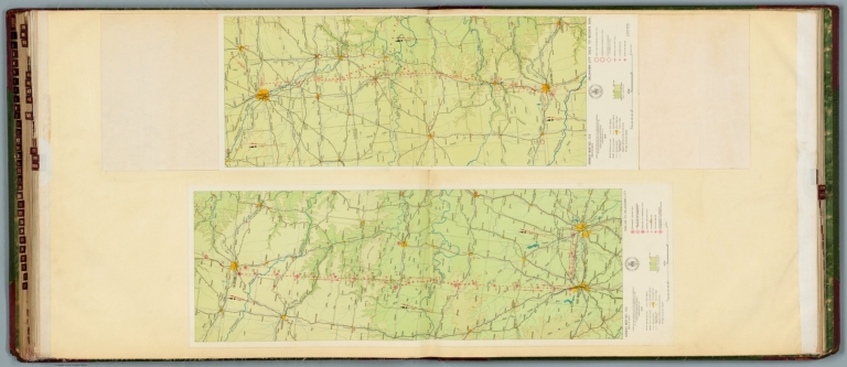
Two aeronautical charts representing the areas from Dallas, Texas, to Oklahoma City, Oklahoma, and from Oklahoma City to Wichita, Kansas. Features military, municipal, and commercial landing fields, as well as beacons. Also shows political boundaries, roads, railways, cities, towns, topography, bodies of water, and drainage. Relief shown with contour lines and color coding. Maps include latitudinal and longitudinal lines, legend, scale statements, and bar scales given in miles, as well as compass roses oriented toward left of sheet (with slight variation between the two maps). With the seal of the Department of Commerce, United States of America. Color lithographs. Together, maps are 56 x 83 cm, on double sheet, 60 x 136 cm.
Author
[Ford Motor Company, U.S. Coast and Geodetic Survey]
Full Title
Airway map no. 104 : Wichita, Kan. to Kansas City Mo. Compiled and printed for the Aeronautics Branch of the Department of Commerce by the Coast and Geodetic Survey, Washington, D.C. 1929. -- Airway map no. 105 : Kansas City, Mo. to Moline, Ill. Compiled and printed for the Aeronautics Branch of the Department of Commerce by the Coast and Geodetic Survey, Washington, D.C. 1930.
List No
14501.033
Note
Two aeronautical charts representing the areas from Wichita, Kansas to Kansas City, Missouri, and from Kansas City to Moline, Illinois. Features military, municipal, and commercial landing fields, as well as beacons. Also shows political boundaries, roads, railways, cities, towns, topography, bodies of water, and drainage. Relief shown with contour lines and color coding. Maps include latitudinal and longitudinal lines, legend, scale statements, and bar scales given in miles, as well as compass roses oriented toward top of sheet (with slight variation between the two maps). With the seal of the Department of Commerce, United States of America. Color lithographs. Together, maps are 54 x 110 cm, on double sheet, 60 x 136 cm.
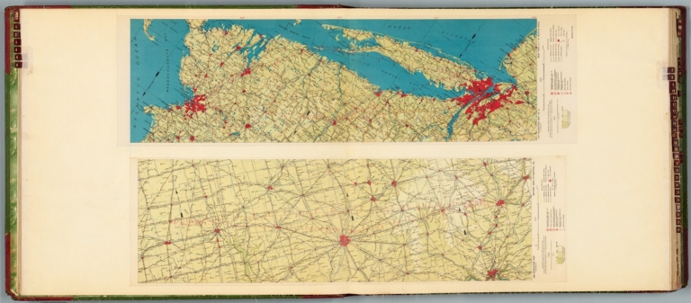
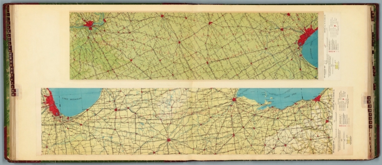
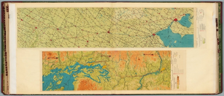
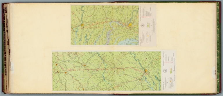
Author
[Ford Motor Company, U.S. Coast and Geodetic Survey]
Full Title
Airway map no. 111 : Chicago Ill. to Milwaukee Wis. Compiled and printed for the Aeronautics Branch of the Department of Commerce by the Coast and Geodetic Survey, Washington, D.C. Jan. 1930. -- Airway map no. 110 : St. Louis Mo. to Chicago Ill. Compiled and printed for the Aeronautics Branch of the Department of Commerce by the Coast and Geodetic Survey, Washington, D.C. 1927.
List No
14501.034
Note
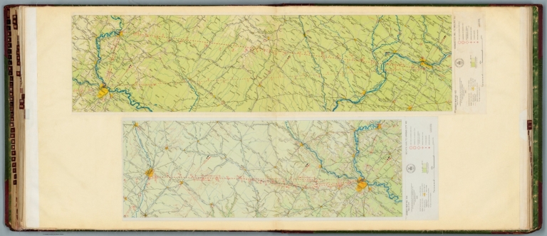
Two aeronautical charts representing the areas from Chicago, Illinois, to Milwaukee, Wisconsin, and from Saint Louis, Missouri, to Chicago, Illinois. Features military, municipal, and commercial landing fields, seaplane anchorage, and beacons. Also shows political boundaries, roads, railways, cities, towns, topography, bodies of water, drainage, and shorelines. Relief shown with contour lines and color coding. Maps include latitudinal and longitudinal lines, legend, scale statements, and bar scales given in miles, as well as compass roses oriented toward left and right of sheet, respectively. With the seal of the Department of Commerce, United States of America. Color lithographs. Together, maps are 56 x 104 cm, on double sheet, 60 x 136 cm. (Map numbers appear in reverse order: first number 111, followed by number 110.)
Author
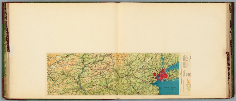
[Ford Motor Company, U.S. Coast and Geodetic Survey, United States. Department of Commerce. Aeronautics Branch. Air Information Division]
Full Title
Airway map no. 112 : Milwaukee to St. Paul - Minneapolis. Compiled and printed for the Aeronautics Branch of the Department of Commerce by the Coast and Geodetic Survey, Washington, D.C. Jan. 1930. -- Airway map of the United States : Information bulletin no. 8. Department of Commerce, Aeronautics Branch, Information Division, Washington, D.C. March 15, 1928.
List No
14501.035
Note
Two aeronautical charts representing the areas from Milwaukee, Wisconsin, to Saint Paul - Minneapolis, Minnesota, and a map of airway routes for the United States and Cuba. Airway map no. 112 features military, municipal, and commercial landing fields, as well as beacons. Also shows political boundaries, roads, railways, cities, towns, topography, bodies of water, drainage, and shorelines. Relief shown with contour lines and color coding. Includes a legend, scale statement, and bar scales given in miles, as well as compass rose oriented toward top of sheet. With the seal of the Department of Commerce, United States of America. The Airway map of the United States shows airway routes under contract or proposed for mail and passengers. Color lithographs and black and white lithograph, respectively. Together, maps are 56 x 118 cm, on double sheet, 60 x 136 cm.
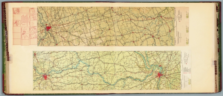
Author
[Ford Motor Company, U.S. Coast and Geodetic Survey]
Full Title
Airway map no. 115 : Louisville Ky to Cleveland Ohio. Compiled and printed for the Aeronautics Branch of the Department of Commerce by the Coast and Geodetic Survey, Washington, D.C. 1929. -- Airway map no. 114 : Cincinnati Ohio to Chicago Ill. Compiled and printed for the Aeronautics Branch of the Department of Commerce by the Coast and Geodetic Survey, Washington, D.C. Jan. 1930.
List No
14501.036
Note
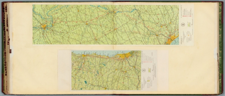
Two aeronautical charts representing the areas from Louisville, Kentucky, to Cleveland, Ohio, and from Cincinnati, Ohio, to Chicago, Illinois. Features military, municipal, and commercial landing fields, seaplane anchorage, beacons, and lighthouse. Also shows political boundaries, roads, railways, cities, towns, topography, bodies of water, drainage, and shorelines. Relief shown with contour lines and color coding. Maps include latitudinal and longitudinal lines, legend, scale statements, and bar scales given in miles, as well as compass roses oriented toward right and left of sheet, respectively. With the seal of the Department of Commerce, United States of America. Color lithographs. Together, maps are 57 x 118 cm, on double sheet, 60 x 135 cm. (Map numbers appear in reverse order: first number 115, followed by number 114.)
Author
[Ford Motor Company, U.S. Coast and Geodetic Survey]
Full Title
Airway map no. 119 : Buffalo N.Y. to Albany N.Y. Compiled and printed for the Aeronautics Branch of the Department of Commerce by the Coast and Geodetic Survey, Washington, D.C. 1929.
List No
14501.037
Note
Aeronautical chart representing the areas from Buffalo to Albany, New York. Features military, municipal, and commercial landing fields, as well as beacons. Also shows political boundaries, roads, railways, cities, towns, topography, bodies of water, drainage, and shorelines. Relief shown with contour lines and color coding. Map includes a legend, scale statement, and bar scale given in miles, as well as a compass rose oriented toward top of sheet. With the seal of the Department of Commerce, United States of America. Color lithograph. Map is 26 x 106 cm, on double sheet, 60 x 135 cm.
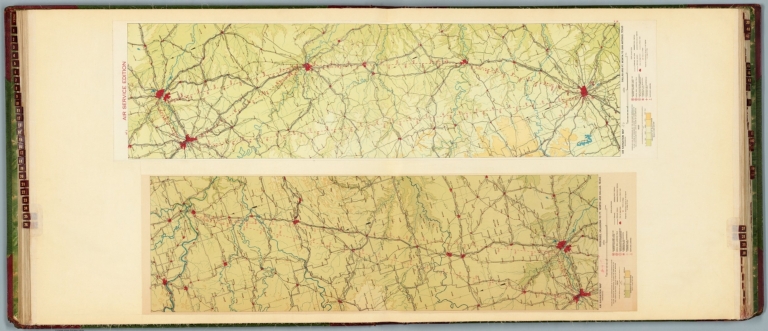
Author
[Ford Motor Company, U.S. Coast and Geodetic Survey]
Full Title
Airway map no. 127 : Birmingham Ala. to Atlanta Ga. Compiled and printed for the Aeronautics Branch of the Department of Commerce by the Coast and Geodetic Survey, Washington, D.C. 1929. -- Airway map no. 128 : Atlanta Ga. to Greensboro N.C. Compiled and printed for the Aeronautics Branch of the Department of Commerce by the Coast and Geodetic Survey, Washington, D.C. 1929.
List No
14501.038
Note
Two aeronautical charts representing the areas from Birmingham, Alabama, to Atlanta, Georgia, and from Atlanta to Greensboro, North Carolina. Features military, municipal, and commercial landing fields, seaplane anchorage and beacons. Also shows political boundaries, roads, railways, cities, towns, topography, bodies of water, and drainage. Relief shown with contour lines and color coding. Maps include latitudinal and longitudinal lines, legend, scale statements, and bar scales given in miles, as well as compass roses oriented toward top of sheet (with slight variation between the two maps). With the seal of the Department of Commerce, United States of America. Color lithographs. Together, maps are 56 x 120 cm, on double sheet, 60 x 135 cm.
Author
[Ford Motor Company, U.S. Coast and Geodetic Survey]
Full Title
Airway map no. 129 : Greensboro N.C. to Richmond Va. Compiled and printed for the Aeronautics Branch of the Department of Commerce by the Coast and Geodetic Survey, Washington, D.C. 1929. -- Airway map no. 130 : Richmond Va. to Washington D.C. Compiled and printed for the Aeronautics Branch of the Department of Commerce by the Coast and Geodetic Survey, Washington, D.C. Jan. 1930.
List No
14501.039
Note
Two aeronautical charts representing the areas from Greensboro, North Carolina, to Richmond, Virginia, and from Richmond, Virginia, to Washington, D.C. Features military, municipal, and commercial landing fields, seaplane anchorage and beacons. Also shows political boundaries, roads, railways, cities, towns, topography, bodies of water, drainage, and shorelines. Relief shown with contour lines and color coding. Maps include latitudinal and longitudinal lines, legend, scale statements, and bar scales given in miles, as well as compass roses oriented toward top and right of sheet, respectively. With the seal of the Department of Commerce, United States of America. Color lithographs. Together, maps are 56 x 81 cm, on double sheet, 60 x 135 cm.
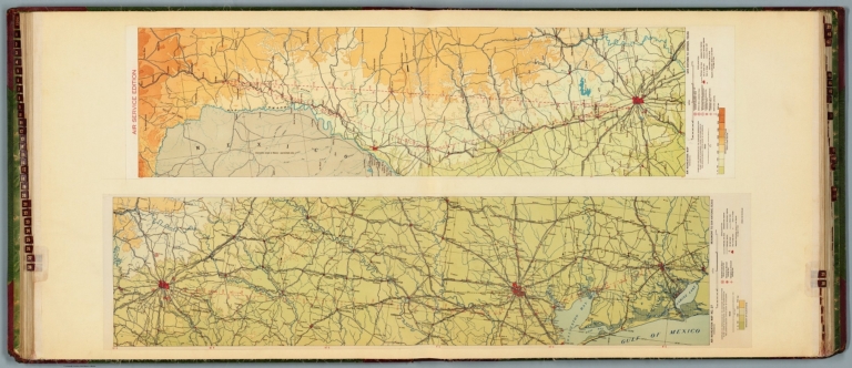
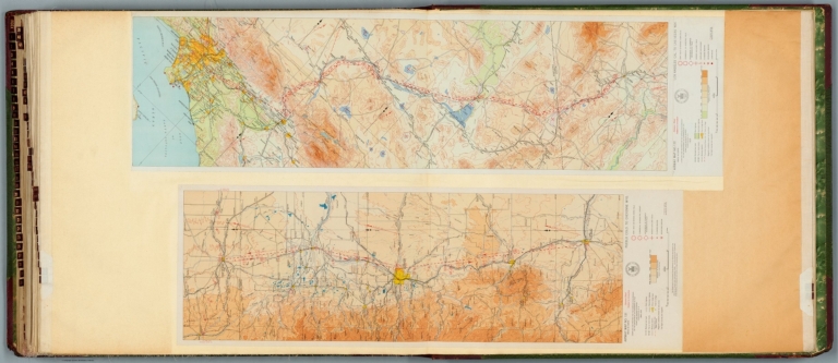
Author
[Ford Motor Company, U.S. Coast and Geodetic Survey]
Full Title
Airway map no. 131 : Pueblo Colo. to Cheyenne Wyo. Compiled and printed for the Aeronautics Branch of the Department of Commerce by the Coast and Geodetic Survey, Washington, D.C. Mar. 1930. -- Airway map no. 132 : Los Angeles Cal. to Las Vegas Nev. Compiled and printed for the Aeronautics Branch of the Department of Commerce by the Coast and Geodetic Survey, Washington, D.C. 1929.
List No
14501.040
Note
Two aeronautical charts representing the areas from Pueblo, Colorado, to Cheyenne, Wyoming, and from Los Angeles, California, to Las Vegas, Nevada. Features military, municipal, and commercial landing fields, seaplane anchorage and beacons. Also shows political boundaries, roads, railways, cities, towns, topography, bodies of water, drainage, and coastlines. Relief shown with contour lines and color coding. Maps include latitudinal and longitudinal lines, legend, scale statements, and bar scales given in miles, as well as compass roses oriented toward left and right of sheet, respectively. With the seal of the Department of Commerce, United States of America. Color lithographs. Together, maps are 56 x 102 cm, on double sheet, 60 x 135 cm.
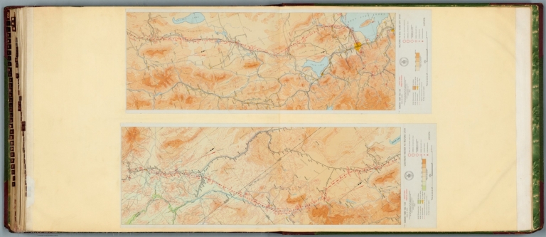
Author
[Ford Motor Company, U.S. Coast and Geodetic Survey]
Full Title
Airway map no. 133 : Las Vegas Nevada to Milford Utah. Compiled and printed for the Aeronautics Branch of the Department of Commerce by the Coast and Geodetic Survey, Washington, D.C. 1929. -- Airway map no. 134 : Milford to Salt Lake City Utah. Compiled and printed for the Aeronautics Branch of the Department of Commerce by the Coast and Geodetic Survey, Washington, D.C. 1929.
List No
14501.041
Note
Two aeronautical charts representing the areas from Las Vegas, Nevada, to Milford, Utah, and from Milford to Salt Lake City, Utah. Features military, municipal, and commercial landing fields, seaplane anchorage and beacons. Also shows political boundaries, roads, railways, cities, towns, topography, bodies of water, drainage, and shorelines. Relief shown with contour lines and color coding. Maps include latitudinal and longitudinal lines, legend, scale statements, and bar scales given in miles, as well as compass roses oriented toward top right of sheet (with slight variation between the two maps). With the seal of the Department of Commerce, United States of America. Color lithographs. Together, maps are 57 x 83 cm, on double sheet, 60 x 135 cm.
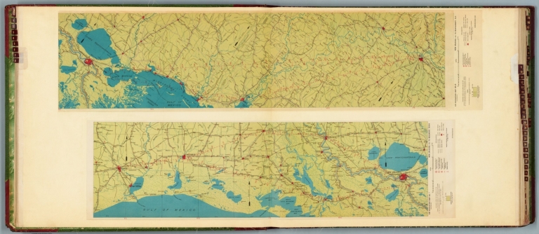
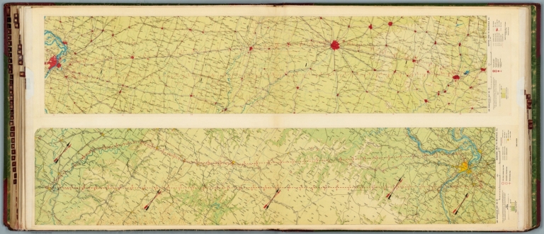
Author
Rand McNally and Company
Full Title
Rand McNally standard map of Alabama. With air trails. No. 101 S. 7 R29. 1 N26. (to accompany) Rand McNally standard indexed and air trails maps of Alabama ... Copyright, 1930, by Rand McNally & Company, Chicago. (inset) Birmingham and vicinity.
List No
11958.003
Note
Air trails map of Alabama, state and county boundaries in outline color. Shows major cities, state capital, county seats, cities, towns, airports, seaplane ports, revolving beacon lights, etc. Includes Air trails legend and index to principal cities. Relief shown by hachures. Prime meridian is Greenwich.
|