COLLECTION NAME:
David Rumsey Historical Map Collection
Record
Author:
Union Atlas Co.
Author:
Warner & Beers
Author:
Worthen, Amos Henry, 1813-1888
Date:
1876
Short Title:
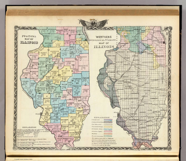
Political map of Illinois. Worthens geological and climate map of Illinois.
Publisher:
Warner & Beers
Publisher Location:
Chicago
Type:
Atlas Map
Obj Height cm:
34
Obj Width cm:
41
Scale 1:
2,000,000
Note:
Two hand col. lithographed maps. Political map shows presidential vote in 1872, and congressional, judicial and senatorial districts. The geologic and climate map is probably based on the "Geological map of the State of Illinois ... made under the direction of by A.H. Worthen, State Geologist" in 1875 (Checklist of printed maps of the Middle West to 1900, 4-1687). Climatic information is average annual rainfall and temperature.
State/Province:
Illinois
Subject:
Climate
Subject:
Geology
Full Title:
Political map of Illinois. Worthens geological and climate map of Illinois. (Union Atlas Co., Warner & Beers, Proprietors. Lakeside Building Cor: of Clark & Adams Sts. Chicago. 1876. Entered ... 1876 by Warner & Beers ... Washington D.C.)
List No:
1159.142
Page No:
151
Series No:
146
Publication Author:
Union Atlas Co.
Publication Author:
Warner & Beers
Pub Date:
1876
Pub Title:
Atlas of the State of Illinois to which are added various general maps, history, statistics and illustrations. Union Atlas Co., Warner & Beers, Proprietors. Lakeside Building Cor: of Clark & Adams Sts. Chicago. 1876. Entered ... 1876 by Warner & Beers ... Washington D.C.
Pub Reference:
Phillips, 1513; LeGear Atlas of the United States, L4062; Phillips Maps of America, p. 330.
Pub Note:
This is very much in the Andreas Minnesota Atlas style - Warner and Beers in fact collaborated with Andreas and did the coloring on the Minnesota Atlas. This 1876 edition bears little resemblance to the earlier 1871 edition by Warner, Higgins & Beers (see our #3749) which used entirely different maps and had no views. Bound in half leather dark brown cloth covered boards with "Atlas of Illinois 1876 illustrated" stamped in gold on the front and blind stamped on the back.
Pub List No:
1159.000
Pub Type:
State Atlas
Pub Maps:
120
Pub Height cm:
46
Pub Width cm:
39
Image No:
1159142
Authors:
Union Atlas Co.; Warner & Beers ; Worthen, Amos Henry, 1813-1888
Collection:
Rumsey Collection