Detail View: David Rumsey Historical Map Collection: Map of the County of Norfolk, Massachusetts.
|
Author:
|
Walling, H. F.
|
|
Date:
|
1858
|
|
Short Title:
|
Map of the County of Norfolk, Massachusetts.
|
|
Publisher:
|
Smith & Bumstead
|
|
Publisher Location:
|
Boston
|
|
Type:
|
Case Map
|
|
Obj Height cm:
|
149
|
|
Obj Width cm:
|
157
|
|
Scale 1:
|
40,000
|
|
Note:
|
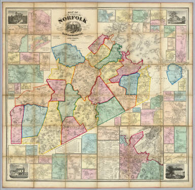
This is a classic Walling county map with four views of prominent residences in the four corners, forty six inset maps of towns, a geological map of the county, a table of distances and a business directory. An earlier, smaller map of Norfolk County was published by Walling in 1853. Map has full hand color, cloth edging, and is dissected into 36 sections. Folds with marbled end sheets into brown cloth covered boards 28.5x27 with ties, titled in gold "Map Of Norfolk County Mass." Shows structures, landowners, etc. Relief shown by hachures.
|
|
Reference:
|
LC Landownership maps, 318.
|
|
State/Province:
|
Massachusetts
|
|
City:
|
Norfolk County (Mass.)
|
|
Full Title:
|
Map of the County of Norfolk, Massachusetts based on the trigonometrical survey of the State. The details from actual surveys under the direction of Henry F. Walling, Supt. of the State map. 1858. Engraved, printed, colored & mounted at H.F. Wallings Map Establishment, No. 90 Fulton St., New York. Published by Smith & Bumstead, 106 Washington St., Boston and 90 Fulton St., New York. Entered ... 1858 by H.F. Walling ... Massachusetts. (with inset maps of Roxbury, Quincy, Dedham, Brookline, Jamaica Plain, geological map, etc.)
|
|
List No:
|
5046.001
|
|
Series No:
|
2
|
|
Publication Author:
|
Walling, H. F.
|
|
Pub Date:
|
1858
|
|
Pub Title:
|
Map of the County of Norfolk, Massachusetts based on the trigonometrical survey of the State. The details from actual surveys under the direction of Henry F. Walling, Supt. of the State map. 1858. Engraved, printed, colored & mounted at H.F. Wallings Map Establishment, No. 90 Fulton St., New York. Published by Smith & Bumstead, 106 Washington St., Boston and 90 Fulton St., New York. Entered ... 1858 by H.F. Walling ... Massachusetts. (with inset maps of Roxbury, Quincy, Dedham, Brookline, Jamaica Plain, geological map, etc.)
|
|
Pub Reference:
|
LC Landownership maps, 318.
|
|
Pub Note:
|
See note field above.
|
|
Pub List No:
|
5046.000
|
|
Pub Type:
|
Case Map
|
|
Pub Maps:
|
1
|
|
Pub Height cm:
|
149
|
|
Pub Width cm:
|
157
|
|
Image No:
|
5046001
|
|
Download 1:
|
|
|
Download 2:
|
|
|
Authors:
|
Walling, H. F.
|
|
Collection:
|
Rumsey Collection
|