COLLECTION NAME:
David Rumsey Historical Map Collection
Record
Author:
Krallert, Wilfried (1912 - 1969)
Date:
1941
Short Title:
Blatt 8. Komorn
Publisher:
Publikationsstelle Wien
Publisher Location:
Vienna
Type:
Separate Map
Obj Height cm:
72
Obj Width cm:
50
Scale 1:
200,000
Country:
Slovakia
Subject:
Ethnography; Nationality; Race
Subject:
Data Visualization
Full Title:
Blatt 8. Komorn
List No:
15851.008
Series No:
8
Publication Author:
Krallert, Wilfried (1912 - 1969)
Pub Date:
1941
Pub Title:
Volkstumskarte der Slowakei / Unter Mitarbeit von E. Brunner, G. Ebel, G. Krallert, F. Volkmann, bearbeitet von Wilfried Krallert auf Grund der Nationalitätsangabe der Zählung der Tschechoslowakei von 1930. 9 Blätter im Masstab 1:200 000.
Pub Reference:
British Library: Cartographic Items Maps 27550.(2.); Staatsbibliothek zu Berlin: Mapp. IX,374 p-1/9; Library of Congress: G1948.S6 K7 1941; Beinecke Library (Yale University): 437ed 1930A; United Nations Archives (Geneva): LON-G6516.E3 s200 .K73; OCLC: 31410034, 557497526, 495081777; Erik ARNBERGER, Handbuch der thematischen Kartographie (1966), p. 98; Mitchell G. ASH, Wolfram NIESS and Ramon PILS (eds.), Geisteswissenschaften im Nationalsozialismus: das Beispiel der Universitat Wien (2010), p, 121; Jeremy Black, A History of the Second World War in 100 Maps (Chicago: University of Chicago Press 2020), pp. 28-9.
Pub Note:
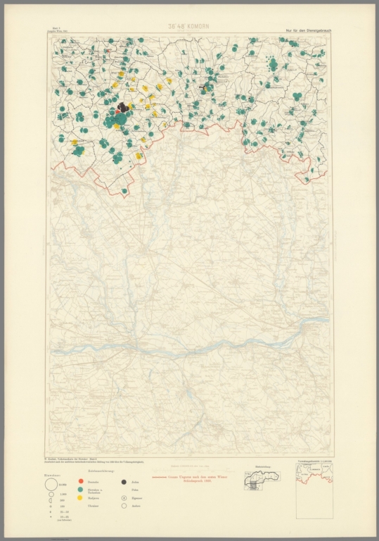
"A colossal and sophisticated ethnographic map of the ‘Slovak State’, the Nazi puppet ‘clerical fascist’ entity that controlled most of modern Slovakia during World War II, that shows the precise locations and populations of all the country’s ethnic Slovak/Czech, German, Hungarian, Ukrainian, Jewish and Roma communities, made by the brilliant but heinous Austrian geographer, commando and spy Wilfried Krallert at the Nazi ethnographic research unit ‘P-Stelle’ in Vienna; published the year before the official start of the Holocaust in Slovakia, the map, classified as ‘For Official Use Only’, was chillingly employed by Axis agents as a blueprint for facilitating the genocide of the majority of country’s Jewish and Roma populations - very rare on the market. On the eve of World War II, and in the wake of Germany’s takeover of Czechoslovakia, the Nazis permitted the creation of the (First) Slovak Republic (Slovak: [Prva] Slovenska republika), alternatively known as the Slovak State (Slovensky štat), a puppet state that comprised most of modern Slovakia (save the southern regions that were given to Hungary by the First Vienna Award of November 2, 1938). The Slovak State existed between March 14, 1939 and April 4, 1945, and was ruled by a malevolent despot, a Roman Catholic priest named Monsignor Jozef Gašpar Tiso, who instituted a regime of ‘clerical fascism’. In 1930, Slovakia had a population of 2.6 million people, of which 85% were ethnically Slovak, while the percentages for the other communities were: Germans (4.8%), Czechs (2.9%), Rusyns (2.6%), Hungarians (2.1%), Jews (1.1%), and Roma (0.9%). Tiso’s regime espoused tremendous enthusiasm for the Nazi’s heinous ethnic cleansing policies that led to the Holocaust. Tiso was so dedicated to annihilating Slovakia’s Jewish community, that he even paid the Nazis 500 Reichsmarks (a considerable sum) for each Jewish person that they deported to their concentration and death camps in Poland. The Holocaust had a devastating impact upon Slovakia’s Jewish community, as of the out of 89,000 Jews in the country in 1940, an estimated 69,000 perished due to Tiso and the Nazis evil endeavours. In order to assist the Nazis and the regimes of their puppet states, in 1941, the Austrian cartographer Wilfried Krallert, an ardent Nazi, created a series of highly sophisticated ethnographic maps of various Eastern European countries, predicated upon the best sources, that showed precisely were different ethnic communities could be located. In addition to the present map of Slovakia, Krallert made the Volkstumskarte von Ungarn, 23 sheets (1941); Volkstumskarte von Rumanien, 44 sheets (1941); and the Volkstumskarte von Jugoslawien, 40 sheets (1941). While superficially the maps, which are void of any overtly rhetorical content, seem like innocent academic endeavors, they were invidious blueprints for genocide, as they allowed Axis agents to locate and capture Jews and Roma, sending them to terrible fates. The Present Work in Focus: Roadmap for The Holocaust in Slovakia The present gargantuan 9-sheet work is a sophisticated ethnographic map of the Slovak State. Created by Wilfried Krallert and his team, it was published in 1941, at the special Nazi ethnographic information office, the ‘Publikationsstelle Wien’, or ‘P-Stelle’ (Vienna). Made to a scale of 1:200,000 and built upon an underlying accurate topographic template shown in grisaille, the overlaying thematic content is noted as having been predicated upon information ‘Bearbeitet nach der amtlichen tschechoslowakischen Zahlung von 1930 uber die Staatszugehorigkeit’ [‘Edited from the official Czechoslovak census of 1930 on nationality’]. The 9 sheets are individually labelled as 1. Lundenburg [including the Title]; 2. Tretchin; 3. Oświecin und Neusohl; 4. Locse und Miscolc; 5. Kassa (Kaschau); 6. Ungvar; 7. Preszburg [Bratislava]; 8. Komorn; and 9. Budapest, Losoncz. The red border line running along the south of Slovakia represents the recently amended frontier with Hungary, noted as ‘Grenze Ungarn nach dem ersten Wiener Schiedsspruch 1939’, being the ‘Border of Hungary after the First Vienna Arbitration Award in 1939 [sic, actually 1938]’. As explained in the legend, in the lower right corner of each sheet, every and town in Slovakia features, under the category ‘Einwohner’ (Residents), a series of colour-coded circles and semi-circles employed to note 6 levels of population in any given place, ranging from 10-25 (trace) to 10,000. Accordingly, the ‘Zeichenerklarung’ [Explanation of Symbols], explains the colour coding of the Einwohner circles, with ‘Deutsche’ (Germans) = orange; ‘Slowaken u, Tschetchen’ (Slovaks and Czechs) = dark green; ‘Madjaren’ (Hungarians) = yellow; ‘Ukrainer’ (Ukrainians) = light green; ‘Juden’ (Jews) = black; ‘Zigeuner’ (Roma) = with a ‘Z’ inside circle. Chillingly, the map which is labeled as being ‘Nur fur den Dienstgebrauch’ [‘For official use only’], shows exactly where all significant communities of Jews and Roma live in Slovakia, so allowing the Slovak State and its Nazi ‘advisers’ to efficiently direct resources to commit genocide against these populations. Notably, the map was highlighted for its historical significance by its appearance as an exhibit held by the British Library, Lie of the Land: The Secret Life of Maps, British Library, 2001-2002. Today, the map is held by several institutions, but is very rare on the market, for we cannot trace any sales records for any other examples. Wilfried Krallert: The Pathfinder of The Holocaust Wilfried Krallert (1912 - 1969) was a brilliant yet truly evil individual who played a major role in enabling the Holocaust in several Eastern European countries. A geography graduate from the University of Vienna, he pursued his doctorate at the Institute for Austrian Historical Research under the well-known Pan-Germanic-chauvinist historian Hans Hirsch. A supporter of Far-Right movements since his teens, Krallert was a zealous ideological Nazi, joining the Party as soon as he was eligible, in 1933. Early in World War II, he was placed in charge of the ‘Publikationsstelle Wien’ (Vienna), often known simply as ‘P-Stelle’, a special research and publishing office dedicated to ethnographic subjects that advanced notions of German racial superiority, and eventually the ethnic cleansing of Jews, Roma and other people targeted by the Nazis. Krallert also worked as a senior agent for the Reichssicherheitshauptamt (RSHA / Reich Security Main Office) and the SS Race and Settlement Main Office. In these capacities, often operating under the pseudonyms “Fritz Bergmann” or “Agent Z”, he conducted espionage missions to various Eastern European countries to gather intelligence on ethnic comminutes that were used to advance the Holocaust. Not long after creating the present map, Krallert served as a member of the ‘Kunsberg Sonderkommando’, a special German military unit that conducted terror and genocide missions in Yugoslavia. In 1943, Krallert was appointed as the head of the ‘RSHA VI G’ (“Scientific-Methodological Research Service”), and in 1944 personally oversaw the looting of Jewish assets in Hungary to finance P-Stelle’s operations. At the end of World War II, Krallert was arrested by the Allies but somehow avoided prosecution, being released from detention in 1948. He subsequently served as a secret agent, variously for the British, French and West German intelligence services, but proved to be unreliable and self-dealing, often selling his employers’ secrets to their enemies." (Alexander Johnson/Dasa Pahor, 2023)
Pub List No:
15851.000
Pub Type:
Separate Map
Pub Maps:
9
Pub Height cm:
72
Pub Width cm:
50
Image No:
15851008.jp2
Authors:
Krallert, Wilfried (1912 - 1969)