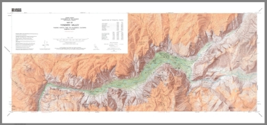
Detail View: David Rumsey Historical Map Collection: Map of Yosemite Valley Yosemite National Park and Wilderness, California Mariposa County
|
Author:
|
USGS (U.S. Geological Survey)
|
|
Date:
|
2010
|
|
Short Title:
|
Map of Yosemite Valley Yosemite National Park and Wilderness, California Mariposa County
|
|
Publisher:
|
USGS (U.S. Geological Survey)
|
|
Publisher Location:
|
Washington D.C.
|
|
Type:
|
Separate Map
|
|
Obj Height cm:
|
41
|
|
Obj Width cm:
|
100
|
|
Scale 1:
|
24,000
|
|
Note:
|
A later reissue of the 1970 edition.
|
|
Region:
|
Yosemite Valley
|
|
Full Title:
|
Map of Yosemite Valley Yosemite National Park and Wilderness, California Mariposa County
|
|
List No:
|
15037.003
|
|
Series No:
|
3
|
|
Publication Author:
|
USGS (U.S. Geological Survey)
|
|
Pub Date:
|
1970
|
|
Pub Title:
|
Map of Yosemite Valley Yosemite National Park and Wilderness, California Mariposa County
|
|
Pub Note:
|
First published in 1858, here updated to 1870 on the first sheet, and then updated again, probably 2010, estimated. Verso of sheet 1 has history and descriptions.
|
|
Pub List No:
|
15037.000
|
|
Pub Type:
|
Separate Map
|
|
Pub Height cm:
|
41
|
|
Pub Width cm:
|
100
|
|
Image No:
|
15037003.jp2
|
|
Download 1:
|
|
|
Download 2:
|
|
|
Authors:
|
USGS (U.S. Geological Survey)
|