Detail View: David Rumsey Historical Map Collection: Arctic Regions.
|
Author:
|
Fullarton, A. & Co.
|
|
Date:
|
1872
|
|
Short Title:
|
Arctic Regions.
|
|
Publisher:
|
A. Fullarton & Co.
|
|
Publisher Location:
|
London and Edinburgh
|
|
Type:
|
Atlas Map
|
|
Obj Height cm:
|
46
|
|
Obj Width cm:
|
31
|
|
Scale 1:
|
Various
|
|
Note:
|
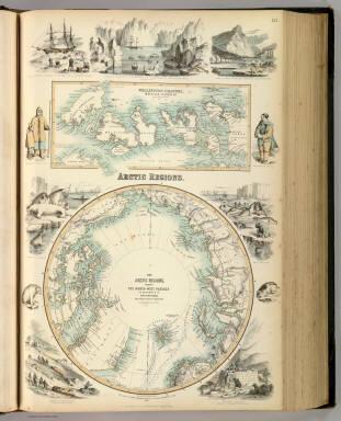
In full color. Maps are surrounded by local scenes, wildlife, and depictions of local people.
|
|
Reference:
|
cf P838 (1862); M&B p182; Tooley Australia 659 (1872); NMM 521.
|
|
World Area:
|
Arctic
|
|
Full Title:
|
Arctic Regions. The Arctic Regions, showing the North-West Passage as determined by Cap. R. McClure and other Arctic Voyagers. Compiled by J. Hugh Johnson, F.R.G.S. (with) Wellington Channel, Melville Island &c. from Admiralty Chart. III. Engraved by A. Fullarton & Co. A. Fullarton & Co. London and Edinburgh.
|
|
List No:
|
3007.003
|
|
Page No:
|
3
|
|
Series No:
|
9
|
|
Engraver or Printer:
|
Johnson, J. Hugh
|
|
Engraver or Printer:
|
McClure, Cap. R.
|
|
Publication Author:
|
Fullarton, A. & Co.
|
|
Pub Date:
|
1872
|
|
Pub Title:
|
The Royal Illustrated Atlas, Of Modern Geography With An Introductory Notice By Dr. N. Shaw, Secretary To The Royal Geographical Society &c. A. Fullarton And Co. London And Edinburgh. (title page only) W.B. Scott. W. Holl.
|
|
Pub Reference:
|
cf P838 (1862); M&B p182; Tooley Australia 659 (1872); NMM 521.
|
|
Pub Note:
|
1st edition 1864; published in 27 parts 1854-62. The date of 1872 is estimated by the Australia map; all the maps are undated and probably date throughout the period 1864 to 1872: the North America map shows Colorado and Russian America while the United States map has no Colorado. The World maps show Alaska. This is the last highly decorative atlas published in England. Even the maps without views or figures are beautifully engraved and colored with a mixture of printed color and hand color. Swanston, Petermann, Bartholomew, Macnab and Johnson engraved the maps. The introduction by Shaw among other things lists important general atlases published over a long period. He lists only one United States atlas, Mitchell's Universal Atlas of 1853! The maps bear a superficial resemblance to Keith Johnston's Royal Atlas. Fullarton frequently gives the sources for his maps - for the United States maps he gives Calvin Smith and Tanner as sources. The atlas is bound in half leather dark green cloth covered boards with "The Royal Illustrated Atlas." stamped in gilt on the cover; the spine reads "Royal Illustrated Atlas" in gold.
|
|
Pub List No:
|
3007.000
|
|
Pub Type:
|
World Atlas
|
|
Pub Maps:
|
76
|
|
Pub Height cm:
|
49
|
|
Pub Width cm:
|
35
|
|
Image No:
|
3007003
|
|
Download 1:
|
|
|
Download 2:
|
|
|
Authors:
|
Fullarton, A. & Co.
|
|
Collection:
|
Rumsey Collection
|