COLLECTION NAME:
David Rumsey Historical Map Collection
Record
Author:
Canet Alvarez, Gerardo A., 1911-
Author:
Raisz, Erwin, 1893-1968
Author:
Harvard University. Institute of Geographical Exploration
Author:
Cuba. Ministerio de Agricultura
Date:
1949
Short Title:
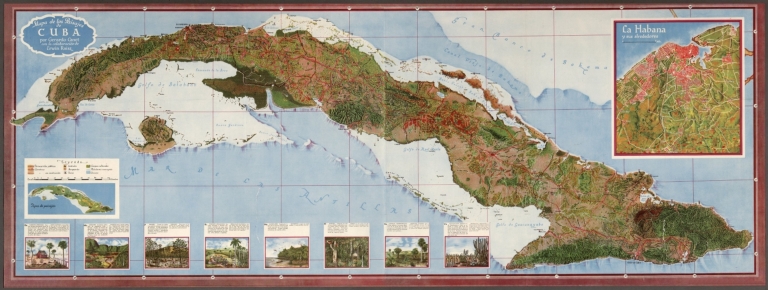
Mapa de los Paisajes de Cuba.
Publisher:
Harvard University Press
Publisher Location:
Cambridge
Type:
Atlas Map
Type:
View
Obj Height cm:
53
Obj Width cm:
146
Scale 1:
750,000
Note:
Map of Cuba. Shows cities, roads, railways, topography, vegetation, drainage, coastline, lighthouses, islands and ocean depths. Relief shown pictorially. Includes latitudinal and longitudinal lines, as well as a legend and bar scale. With two inset maps: Tipos de paisajes [= Types of landscapes] -- La Habana y sus alrededores [= Havana and its surroundings]. In addition, with views depicting various ecosystem types, accompanied by descriptive text, which appears in Spanish, with English translations. Map is 53 x 146 cm, on fold-out sheet 56 x 151 cm.
Country:
Cuba
City:
Havana (Cuba)
Subject:
Pictorial map
Full Title:
Mapa de los Paisajes de Cuba por Gerardo Canet con la colaboración de Erwin Raisz.
List No:
14350.037
Series No:
37
Publication Author:
Canet Alvarez, Gerardo A., 1911-
Publication Author:
Raisz, Erwin, 1893-1968
Publication Author:
Harvard University. Institute of Geographical Exploration
Publication Author:
Cuba. Ministerio de Agricultura
Pub Date:
1949
Pub Title:
Altas de Cuba por Gerardo Canet, Profesor de Geografía en el INstituto de la Víbora, La Habana. Bacario de la John Simon Guggenheim Memorial Foundation. Representante Nacional de la Comisión de Cartografía del Instituto Panamericano de Geografía e Historia. Con la colaboración de Erwin Raisz, Cartógrafo del Instituto de Exploraciones Geográficas Universidad de Harvard. Preparado en el Instituto de Exploraciones Geográficas de la Universidad de Harvard y publicado en cooperación con el Ministerio de Agricultura de la República de Cuba. Cambridge, Massachusetts : Harvard University Press, 1949.
Pub Note:
Altas de Cuba, by Gerardo Canet and Erwin Raisz; published in 1949 by the Institute of Geographical Exploration at Harvard University. Bound in thin maroon-colored board, with title in gold on front cover. With ink inscription: Para Roberto ... Agosto 195. Collation: [1] plate, 63 pages, [1] plate, with 1 fold-out map. Volume contains 32 plates, including 29 double and 1 fold-out, comprised of maps, views, diagrams and charts. Includes table of contents, Introduction, index and bibliography. Maps show cities, administrative boundaries, roads, railways, air routes, topography, vegetation, drainage, coastline, islands and lighthouses. In addition, maps feature themes illustrating life in Cuba, such as its weather, agricultural and mineral resources, economy, transportation and education. Maps use pictorial elements and are accompanied by views, diagrams and charts, as well as descriptive text, which appears in Spanish, with English translations. Introduction excerpt: This Atlas is more than an attempt to describe Cuba. Our aim is not only to present the setting in which the drama of Cuban life is played but to show how this life itself changes its own setting, creating new problems and new adjustments to them. by visual representation the most complicated problems may be brought within the understanding of the layman. Everyone should know the geography of his own country, and in the case of Cuba this need is imperative, since few countries have such clear-cut dependence on location, climate and soil Cuba’s internal problems of adjustment and interdependence with the rest of the world demand a high degree of understanding from its citizens. “The atlas is result of collaboration between Raisz, the American cartographer born in Hungary and a Cuban geographer and cartographer, Canet. Using Canet’s words in the Introduction, the atlas is “a living picture of Cuban Geography”. A total of 34 themes were represented by maps and graphics, presenting the history of the country, its’ physical geographical characteristics, the major parameters to describe the society (standard of living, health, social composition, government, etc.) and the national economy. The atlas is the rich combination of maps with pictures, charts and text. The authors not only wanted to create an atlas for scientists and specialists with the different topics represented in the maps: their intention was to make all this information available and easily understandable for the public in general. The atlas joined two peculiar cartographic styles: the delicacy of the drawing ability of Erwin Raisz and Canet’s interest to represent the broader spectrum of data collected by him, using all the graphic tools at their disposal to make the atlas more attractive.” - José Jesús Reyes Nunez, Eötvös Loránd University in Budapest, Hungary.
Pub List No:
14350.000
Pub Type:
National Atlas
Pub Maps:
32
Pub Height cm:
34
Pub Width cm:
26
Image No:
14350037.jp2
Authors:
Canet Alvarez, Gerardo A., 1911-; Raisz, Erwin, 1893-1968; Harvard University. Institute of Geographical Exploration; Cuba. Ministerio de Agricultura
