C.S. Hammond & Company. London: George Philip & Son, Ltd. The London Geographical Institute
publisher
C.S. Hammond & Company. London: George Philip & Son, Ltd. The London Geographical Institute
Publisher
false
Publisher Location:
New York
publisher_location
New York
Publisher Location
false
Publisher:
Philip, Son & Nephew, Ltd.
publisher
Philip, Son & Nephew, Ltd.
Publisher
false
Publisher Location:
Liverpool
publisher_location
Liverpool
Publisher Location
false
Type:
Atlas Map
type
Atlas Map
Type
false
Obj Height cm:
48
obj_height_cm
48
Obj Height cm
false
Obj Width cm:
67
obj_width_cm
67
Obj Width cm
false
Scale 1:
20,000,000
scale_1
20,000,000
Scale 1
false
Note:
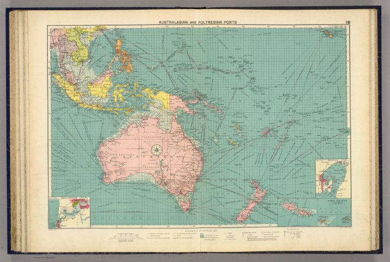
Color lithographed map. Depths shown by layer tints. Shows mail routes and duration, steamship routes, distances, navigable waters for large steamers, canals, principal railways, cables, lighthouses, lightships, docks, coaling stations, British and American consular offices, naval stations, dockyards, etc. Inset maps: Perth & Fremantle. Scale 1:200,000 -- Wellington. Scale 1:200,000 -- Samoa Islands. Scale 1:2,500,000.
note
Color lithographed map. Depths shown by layer tints. Shows mail routes and duration, steamship routes, distances, navigable waters for large steamers, canals, principal railways, cables, lighthouses, lightships, docks, coaling stations, British and American consular offices, naval stations, dockyards, etc. Inset maps: Perth & Fremantle. Scale 1:200,000 -- Wellington. Scale 1:200,000 -- Samoa Islands. Scale 1:2,500,000.
Note
false
World Area:
Pacific
world_area
Pacific
World Area
false
Country:
Australia
country
Australia
Country
false
Country:
Indonesia
country
Indonesia
Country
false
Region:
Samoan Islands
region
Samoan Islands
Region
false
Subject:
Shipping
subject
Shipping
Subject
false
Full Title:
Australasian and Polynesian ports. George Philip & Son, Ltd. The London Geographical Institute. (1922)
full_title
Australasian and Polynesian ports. George Philip & Son, Ltd. The London Geographical Institute. (1922)
Full Title
false
List No:
5746.021
list_no
5746.021
List No
false
Page No:
15
page_no
15
Page No
false
Series No:
26
series_no
26
Series No
false
Engraver or Printer:
C.S. Hammond & Co.
engraver_or_printer
C.S. Hammond & Co.
Engraver or Printer
false
Engraver or Printer:
George Philip & Son
engraver_or_printer
George Philip & Son
Engraver or Printer
false
Engraver or Printer:
London Geographical Institute
engraver_or_printer
London Geographical Institute
Engraver or Printer
false
Engraver or Printer:
Philip, Son & Nephew
engraver_or_printer
Philip, Son & Nephew
Engraver or Printer
false
Publication Author:
Philip, George
publication_author
Philip, George
Publication Author
false
Pub Date:
1922
pub_date
1922
Pub Date
false
Pub Title:
New mercantile marine atlas. A series of 35 plates containing over 200 charts and plans with tables of 12,000 distances between ports. Supplemented by a new and original diagrammatic chart for calculating speed, time & distance; national and commercial flags, cable, oiling stations and wireless telegraphy charts with list of wireless stations, and complete index of over 20,000 ports, &c. Specially designed for merchant shippers, exporters & ocean travellers and for general use. Edited by George Philip, F.R.G.S. Ninth edition. C.S. Hammond & Company, publishers, New York City, U.S.A. London: George Philip & Son, Ltd., the London Geographical Institute, 32 Fleet Street, E.C. Liverpool: Philip, Son & Nephew, Ltd., 20 Church St. (1922)
pub_title
New mercantile marine atlas. A series of 35 plates containing over 200 charts and plans with tables of 12,000 distances between ports. Supplemented by a new and original diagrammatic chart for calculating speed, time & distance; national and commercial flags, cable, oiling stations and wireless telegraphy charts with list of wireless stations, and complete index of over 20,000 ports, &c. Specially designed for merchant shippers, exporters & ocean travellers and for general use. Edited by George Philip, F.R.G.S. Ninth edition. C.S. Hammond & Company, publishers, New York City, U.S.A. London: George Philip & Son, Ltd., the London Geographical Institute, 32 Fleet Street, E.C. Liverpool: Philip, Son & Nephew, Ltd., 20 Church St. (1922)
<a href="https://www.extensis.com/support/geoviewer-9" target="_blank">GeoViewer for JP2 and SID files</a>
Download 2
false
Authors:
Philip, George
author_thumbnail_label
Philip, George
Authors
false
Collection:
Rumsey Collection
institution
Rumsey Collection
Collection
false
Custom:
AI-Generated Summary:
The work titled "Australasian and Polynesian Ports" is an atlas map created by George Philip in 1922, with contributions from C.S. Hammond & Company and the London Geographical Institute. The map is part of a world atlas, measuring 67 cm in width and 48 cm in height. It is printed using a color lithograph technique, which was a common method for producing detailed and colorful maps during that period.
This map covers the Pacific region, specifically focusing on Australia, Indonesia, and the Samoan Islands. It is designed at a scale of 1:20,000,000, providing a broad overview of the area. The map includes additional inset maps of Perth & Fremantle, Wellington, and the Samoa Islands at varying scales, offering more detailed views of those regions.
The composition of the map is visually striking, with the use of different colors to denote various territories and geographical features. Australia is prominently displayed in pink, while surrounding regions are depicted in shades of yellow and green. The ocean is represented in a light blue hue, with shipping paths intricately marked across the waters.
The map's primary focus is on shipping routes, which are meticulously illustrated with lines connecting major ports. The routes indicate mail routes, steamship paths, distances, and navigable waters for large steamers. Additional features include canals, principal railways, cables, lighthouses, lightships, docks, coaling stations, and naval stations, highlighting the infrastructure supporting maritime navigation and trade.
Inscribed on the map are various notations indicating the presence of British and American consular offices, which were essential for supporting maritime and trading activities in the early 20th century. This reflects the colonial and geopolitical interests in the Pacific region during that era.
The map's style is typical of early 20th-century cartography, characterized by precise detailing and an emphasis on practical information for navigation and trade. The use of color and detailed annotations convey both the complexity and the importance of maritime routes in connecting distant parts of the world.
Culturally and historically, this map provides insight into the geopolitical landscape of the time, illustrating the importance of the Pacific region in global shipping and colonial influence. The presence of British and American consular offices signifies the strategic interests of these powers in the area.
The map is part of a larger collection found in the Rumsey Collection, identified by the "Pub List No" 5746.000 and "List No" 5746.021. This collection is a valuable resource for understanding the historical context of maritime navigation and the role of cartography in documenting and facilitating global trade networks during the early 20th century.