Detail View: David Rumsey Historical Map Collection: Punchinello-graphy of England
|
Author:
|
Wauthier, John M.
|
|
Date:
|
1808
|
|
Short Title:
|
Punchinello-graphy of England
|
|
Publisher:
|
Peter Didier and William Tebbett
|
|
Publisher Location:
|
London
|
|
Type:
|
Game Map
|
|
Obj Height cm:
|
57
|
|
Obj Width cm:
|
48
|
|
Country:
|
England
|
|
Country:
|
Wales
|
|
Subject:
|
Pictorial map
|
|
Subject:
|
Satirical
|
|
Full Title:
|
Punchinello-graphy of England
|
|
List No:
|
10652.005
|
|
Series No:
|
5
|
|
Publication Author:
|
Wauthier, John M.
|
|
Pub Date:
|
1808
|
|
Pub Title:
|
Punchinello-graphy of England
|
|
Pub Reference:
|
OCLC: 498146882 (locates 2 copies only, one in the UK and one in the US). Muir, English Children’s Books, 1600 to 1900. p 225 Whitehouse, Victorian Table Games p. 99
|
|
Pub Note:
|
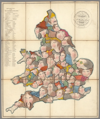
"In this beautifully engraved game, each English or Welsh county is represented by a grotesque portrait of a character from history, literature or folklore; a numbered list appears in the left hand margin. Counters with these characters’ names (which may have been printed, or may have been handwritten, but are not present here) were picked from a bag. The player then had to name the county and repeat the list of principal towns given in the rules. Failure gave other players the chance to complete the list and win the token. The rules suggest awarding ‘some present’ to the winner, to ‘awaken emulation’ in the breast of the other pupils. With the exception of Tom Thumb, who represents Rutland (England’s smallest county) there is no obvious connection between the characters and the locations: Cardinal Wolsey has no obvious connection with Radnor, the demonised radical MP John Wilkes none with Gloucestershire and I can think of nothing which links Joan of Arc with Yorkshire. Some historical figures would have figured more prominently in popular culture then than now: ‘Obi, or 3 Finger’d Jack’, or Jack Mansong, led a slave revolt in 1770s Jamaica and featured in plays, novels and broadsides. King Lear is drawn from Shakespeare, Squire Weston and Parson Thwackum from Fielding and Sir Fretful Plagiary from Sherridan. Surprisingly, perhaps, none of these characters are described in the rules, and learning about them is not part of the game. Percy Muir cites the game as an example of the ‘more lively titles’ which began to appear in the early 19th century, promising ‘something more palatable to juvenile taste’. Whitehouse lists it as a game which was known to have been published but does not appear to have seen a copy and supplies no details. He gives the publisher as John Harris, which suggests he was only aware of a later version. The original publishers were Peter Didier and William Tebbett of 75 St James’s Street, and it was advertised in the 16 January 1808 edition of the ‘Oxford University and City Herald’, as being available from Didier and Tebbett’s ‘Juvenile Library of English French and Italian Books and instructive games’. In the same year they published a conventional folding map of England and Wales, a ‘traveller’s guide’, as a counterpart to the Punchinellography. Their output included more general works, including an 1807 plan of London, but children’s books and educational games seem to have been their core business. They collaborated with John M Wauthier (fl. 1803-1823) on other projects, including atlases of ancient geography and European history and an 1807 map of England ‘being a map of that Kingdom illustrative of the principal battles fought in it’. As reported in the ‘London Gazette’ Didier and Tebbett were declared bankrupt in 1810. A handful of books appear under their imprint dated 1811, but the lease and contents of 75 St James’s Street, including an ‘elegant stock of bound books’ was auctioned in March 1810 (‘Morning Chronicle’ March 10 1810). A further entry in the ‘Gazette’ suggests that proceedings dragged on into 1812; final claims were settled then, or disallowed. This may explain why the ‘Punchinellography’ appears in a catalogue of John Harris’ stock in the same year (bound at the end of Sandham’s ‘Travels of St Paul’, published by Harris in 1812): Harris may have bought copies at the auction in 1810, or acquired them subsequently, perhaps in settlement of an outstanding debt. It is not clear if it was revised to show his imprint. It seems at least as likely, though, that Harris’ involvement demonstrates that something was salvaged from the ruins. Didier and Tebbett had collaborated with Harris before their bankruptcy, and we find editions of the abbé Gaultier’s ‘Complete course of geography’ published in 1811 and 1813 under the joint imprint of Harris and P. Didier, who had moved north to Bolsover Street." (Tim Bryars, 2020)
|
|
Pub List No:
|
10652.000
|
|
Pub Type:
|
Game Map
|
|
Pub Height cm:
|
16
|
|
Pub Width cm:
|
11
|
|
Image No:
|
10652005.jp2
|
|
Download 1:
|
|
|
Download 2:
|
|
|
Authors:
|
Wauthier, John M.
|