Detail View: David Rumsey Historical Map Collection: Ukrainae
|
Author:
|
Le Vasseur de Beauplan, Guillaume
|
|
Date:
|
1650
|
|
Short Title:
|
Ukrainae
|
|
Publisher:
|
Willem Hondius
|
|
Publisher Location:
|
Gdansk
|
|
Type:
|
Atlas Map
|
|
Type:
|
Wall Map
|
|
Obj Height cm:
|
91
|
|
Obj Width cm:
|
216
|
|
Scale 1:
|
Scale not determined.
|
|
Note:
|
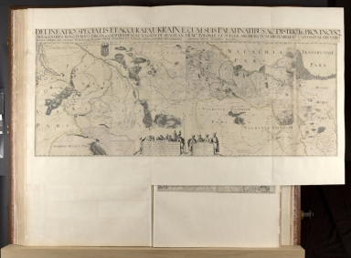
Oriented with north at the bottom. 1 map : copperplate engraving on 8 sheets, hand colour. Section of the Dniepr inset on a curtain in the top left corner of the map. Arms of the Kingdom of Poland at the top edge. Two tablets at the bottom of the map, one contianing the scale bars, the other a key, both surrounded by figures in regional dress. Born in Normandy, Beauplan entered the service of the Polish Monarchy as a soldier in 1630, and in 1637-8 he was sent to Ukraine, where he collected material for the first descriptive map of that country, which he completed in 1639. In that same year he also led an expedition down the Dniepr River, and over the next few years he added more regions to his map: the southern part of the Dniepr, Podole, Pokucie and Wołyń. In 1645 he received permission from King Wiadyslaw IV to have some of his researches engraved as a wall or ‘special’ map, which was undertaken in Gdańsk by Willem Hondius, another émigré in the service of the Polish court. According to the dates on the map Hondius finished the plates in 1650, by which time Beauplan had returned to Poland and was able to make final alterations to the plates. A smaller but more extensive map of Beauplan’s was also engraved by Hondius in 1654, which was soon copied, notably by the Blaeus.
|
|
Country:
|
Ukraine
|
|
Country:
|
Poland
|
|
Full Title:
|
Delineatio Specialis Et Accurata Ukrainae Cum Suis Palatinatibus Ac Districtibq Provincysq Adiacentibus Bono Publico Erecta Per Guilhelmum Le Vasseur De Beauplan S.R.Mtis Poloniæ Et Sueciæ Architectum Militarem Et Capitaneum Æri Vero Incisa Opera Et Studio Wilhelmi Hondy S.R.Mis Poloniæ Et Sueciæ Chalcographi Privilegiati, Gedani Anno Domini M.C D.L. / Guilhelmus le Vasseur de Beauplan S.R.Mtis. Architectus Militaris et Capitaneus mensuravit et delineavit. ; Wilhelmus Hondius S.R.Mtis. Chalcographus sculpsit Cum privilegio S. R. Majtis. in triginta Annos. Gedani Ano. MDCL.
|
|
List No:
|
10151.036
|
|
Page No:
|
BL System Number 004948639 Maps K.A.R.(32).
|
|
Series No:
|
36
|
|
Publication Author:
|
Blaeu, Joan, 1596-1673
|
|
Publication Author:
|
Hondius, Jodocus, 1563-1612
|
|
Publication Author:
|
Visscher, Claes Jansz
|
|
Publication Author:
|
Blaeu, Willem Janszoon, 1571-1638
|
|
Publication Author:
|
Tassin, Christophe Nicolas
|
|
Pub Date:
|
1660
|
|
Pub Title:
|
(Klencke Atlas). Orbis Terræ Compendium, Carolo Secundo dedicatum a I. Kliencke (a Collection of Maps by Blaeu, Hondius, Visscher, &c.)
|
|
Pub Reference:
|
British Library Maps K.A.R. R. Shirley, The Mapping of the World: Early Printed World Maps 1472-1700, London, 1993, 2nd ed, pp. 392-6, no. 371. In the Catalogue of Maps, Prints, Drawings, etc., forming the geographical and topographical collection attached to the Library of his late Majesty King George the third, etc., London, 1829. .British Museum, Catalogue of Maps, Prints, Drawings, etc., forming the geographical and topographical collection attached to the Library of his late Majesty King George the third, etc., London, 1829
|
|
Pub Note:
|
The Klencke Atlas resides at the British Library and we are grateful to them for providing scanned images of the atlas and complete catalog metadata as part of a joint project to scan and catalog the maps and atlases from the low countries of Europe that are part of the King George III Topographical Collections. From the British Library description: "The Klencke Atlas is one of the world's biggest: it measures 176 x 231 cm when open. It takes its name from Joannes Klencke, who presented it to Charles II on his restoration to the British thrones in 1660. Its size and its 40 or so large wall maps from the Golden Age of Dutch mapmaking were supposed to suggest that it contained all the knowledge in the world. At another level, it was a bribe intended to spur the King into granting Klencke and his associates trading privileges and titles. Charles, who was a map enthusiast, appreciated the gift. He placed the atlas with his most precious possessions in his cabinet of curiosities, and Klencke was knighted. Later generations have benefited too. The binding has protected the wall maps which have survived for us to enjoy - unlike the vast majority of other wall maps which, exposed to light, heat and dirt when hung on walls, have crumbled away. Titled 'Orbis Terræ Compendium, Carolo Secundo dedicatum a I. Kliencke. i.e. a Collection of Maps by Blaeu, Hondius, Visscher, &c. One Volume 5 feet 10 inches by 3 feet 2 inches." For more on the Klencke Atlas, see the British Library website, https://www.bl.uk/collection-items/klencke-atlas
|
|
Pub List No:
|
10151.000
|
|
Pub Type:
|
World Atlas
|
|
Pub Maps:
|
42
|
|
Pub Height cm:
|
176
|
|
Pub Width cm:
|
116
|
|
Image No:
|
10151036.jp2
|
|
Download 1:
|
|
|
Download 2:
|
|
|
Authors:
|
Beauplan, Guillaume Le Vasseur, sieur de, approximately 1600- cartographer.
|