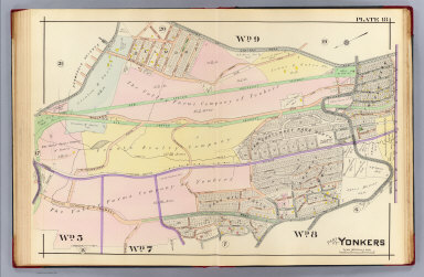
Detail View: David Rumsey Historical Map Collection: 18. Yonkers.
|
Attributed Author:
|
Kiser, Ellis
|
|
Attributed Author:
|
Mueller, A. H.
|
|
Date:
|
1907
|
|
Short Title:
|
18. Yonkers.
|
|
Publisher:
|
A.H. Mueller
|
|
Publisher Location:
|
Philadelphia
|
|
Type:
|
Atlas Map
|
|
Obj Height cm:
|
54
|
|
Obj Width cm:
|
81
|
|
Scale 1:
|
3,600
|
|
Note:
|
Hand colored map. Maps in this atlas show buildings by construction material (stone, brick, frame, iron) with name or function, landowners, fire hydrants, water and sewer pipes, railroads, paved, unpaved and unopened streets, aqueducts and city and ward boundaries. Includes Lincoln Station, Dunwoodie Station, Van Cortlandt Park North, Lincoln Park, Lowerre Summit and Park Hill South.
|
|
State/Province:
|
New York
|
|
City:
|
Yonkers (N.Y.)
|
|
Full Title:
|
Part of Yonkers. Plate 18. (A.H. Mueller, lith., Philada., 1907)
|
|
List No:
|
0650.019
|
|
Page No:
|
18
|
|
Series No:
|
22
|
|
Publication Author:
|
Kiser, Ellis
|
|
Publication Author:
|
Mueller, A. H.
|
|
Pub Date:
|
1907
|
|
Pub Title:
|
Atlas of the city of Yonkers, Westchester County, New York. Also embracing north-west section of the borough of Bronx. Compiled from official records, private plans and actual surveys, by Ellis Kiser, C.E. Under the direct management and supervision of A.H. Mueller, publisher, 530 Locust Street, Philadelphia, Pa., 1907. A.H. Mueller, Lithographer, 530 Locust St., Philadelphia. Copyright, A.D. 1907, by A.H. Mueller.
|
|
Pub Reference:
|
P2337; U.S. Atlases L2678.
|
|
Pub Note:
|
See note field above.
|
|
Pub List No:
|
0650.000
|
|
Pub Type:
|
City Atlas
|
|
Pub Maps:
|
26
|
|
Pub Height cm:
|
58
|
|
Pub Width cm:
|
44
|
|
Image No:
|
0650019
|
|
Download 1:
|
|
|
Download 2:
|
|
|
Authors:
|
Kiser, Ellis; Mueller, A. H.
|
|
Collection:
|
Rumsey Collection
|