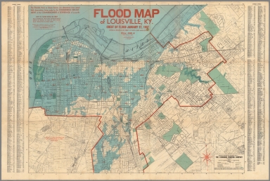
Detail View: David Rumsey Historical Map Collection: Louisville Flood Map Showing Flooded Area of Louisville, Kentucky. January 1937.
|
Author:
|
The Standard Printing Company Incorporated
|
|
Date:
|
1938
|
|
Short Title:
|
Louisville Flood Map Showing Flooded Area of Louisville, Kentucky. January 1937.
|
|
Publisher:
|
The Standard Printing Company Incorporated
|
|
Publisher Location:
|
Louisville
|
|
Type:
|
Separate Map
|
|
Obj Height cm:
|
71
|
|
Obj Width cm:
|
107
|
|
Scale 1:
|
20,000
|
|
City:
|
Louisville (Kty.)
|
|
Full Title:
|
Louisville Flood Map Showing Flooded Area of Louisville, Kentucky. January 1937. Price 50¢. Copyright ... The Standard Printing Company Incorporated, Louisville, Kentucky, U.S.A.
|
|
List No:
|
9033.003
|
|
Page No:
|
map
|
|
Series No:
|
3
|
|
Publication Author:
|
The Standard Printing Company Incorporated
|
|
Pub Date:
|
1938
|
|
Pub Title:
|
Louisville Flood Map Showing Flooded Area of Louisville, Kentucky. January 1937. Price 50¢. Copyright ... The Standard Printing Company Incorporated, Louisville, Kentucky, U.S.A.
|
|
Pub Note:
|
Color.
|
|
Pub List No:
|
9033.000
|
|
Pub Type:
|
Separate Map
|
|
Pub Maps:
|
1
|
|
Pub Height cm:
|
25
|
|
Pub Width cm:
|
12
|
|
Image No:
|
9033003.jp2
|
|
Download 1:
|
|
|
Download 2:
|
|
|
Authors:
|
The Standard Printing Company Incorporated
|