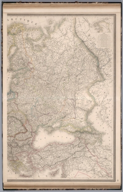
Detail View: David Rumsey Historical Map Collection: Carte Physique and Politique de l'Europe (eastern sheet).
|
Author:
|
Andriveau-Goujon, E.
|
|
Date:
|
1853
|
|
Short Title:
|
Carte Physique and Politique de l'Europe (eastern sheet).
|
|
Publisher:
|
Chez J. Andriveau-Goujon
|
|
Type:
|
Atlas Map
|
|
Obj Height cm:
|
99
|
|
Obj Width cm:
|
67
|
|
Scale 1:
|
44,300,000
|
|
World Area:
|
Europe
|
|
Full Title:
|
Carte Physique and Politique de l'Europe (eastern sheet).
|
|
List No:
|
12050.025
|
|
Page No:
|
22
|
|
Series No:
|
25
|
|
Engraver or Printer:
|
P. Flahaut
|
|
Publication Author:
|
Andriveau-Goujon, E.
|
|
Pub Date:
|
1854
|
|
Pub Title:
|
Atlas de Choix, ou Recueil des Meilleures Cartes de Geographie Ancienne et Moderne Dressees par Divers Auteurs. Table. Paris. Chez J. Andriveau-Goujon.
|
|
Pub Note:
|
This atlas was published in many compilations over a thirty year period. It was indeed an atlas of "choice" of the publisher and as such consists of a wide variety of maps that Andriveau-Goujon favored to include at the time. It consists of ancient and modern geographical maps, engraved and hand colored. Date estimated; based on newest map sheet in atlas, 1854.
|
|
Pub List No:
|
12050.000
|
|
Pub Type:
|
World Atlas
|
|
Pub Maps:
|
60
|
|
Pub Height cm:
|
70
|
|
Pub Width cm:
|
51
|
|
Image No:
|
12050025.jp2
|
|
Download 1:
|
|
|
Download 2:
|
|
|
Authors:
|
Andriveau-Goujon, E.
|