Detail View: David Rumsey Historical Map Collection: Territory of Dakota
|
Author:
|
U.S. General Land Office
|
|
Date:
|
1876
|
|
Short Title:
|
Territory of Dakota
|
|
Publisher:
|
Julius Bien
|
|
Publisher Location:
|
New York
|
|
Type:
|
Atlas Map
|
|
Obj Height cm:
|
74
|
|
Obj Width cm:
|
62
|
|
Scale 1:
|
1,140,480
|
|
Note:
|
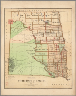
Color map. Includes references. Relief shown by hachures. Prime meridian is Greenwich.
|
|
State/Province:
|
North Dakota
|
|
State/Province:
|
South Dakota
|
|
Full Title:
|
Department of the Interior, General Land Office. S.S. Burdett, Commissioner.Territory of Dakota. 1876. Compiled from the official records of the General Land Office and other sources by C. Roeser, Principal Draughtsman G.L.O. Photolith. & Print by Julius Bien 16 & 18 Park Place, N.Y.
|
|
List No:
|
11179.008
|
|
Page No:
|
(6)
|
|
Series No:
|
8
|
|
Engraver or Printer:
|
S.S. Burdett
|
|
Engraver or Printer:
|
Roeser, C.
|
|
Publication Author:
|
U.S. General Land Office
|
|
Pub Date:
|
1876
|
|
Pub Title:
|
Department of the Interior, General Land Office. Geographical and political atlas of the states and territories of the United States of America in which the Public Land Surveys are now in operation. S.S. Burdett, Commissioner. Washington City. 1876. Julius Bien, Photolith. & Print.
|
|
Pub Note:
|
Atlas in 20 plates,19 color maps. Including:1- New Mexico. 2-Idaho. 3-Kansas. 4-Washington. 5-Louisiana. 6-Dakota. 7-Nebraska. 8-Wyoming. 9- Arizona. 10-Utah. 11-Nevada. 12-Indian Territory.- 13-Oregon. 14-Montana. 15-Florida. 16-California in 2 shoots. 17-Minnesota. 18-Colorado. Maps showing land offices, townships subdivided, county seats, cities, towns, boundaries of land districts, railroad limits, military reservations, boundaries of counties, and Indian reservations. "Compiled from the official records of the General Land Office and other sources by C. Roeser, Principal Draughtsman G.L.O."
|
|
Pub List No:
|
11179.000
|
|
Pub Type:
|
National Atlas
|
|
Pub Maps:
|
19
|
|
Pub Height cm:
|
70
|
|
Pub Width cm:
|
88
|
|
Image No:
|
11179008.jp2
|
|
Download 1:
|
|
|
Download 2:
|
|
|
Authors:
|
U.S. General Land Office
|