COLLECTION NAME:
David Rumsey Historical Map Collection
Record
Author:
Beauregard, G. T.
Author:
Confederate States of America. Army
Date:
1895
Short Title:
Forts Sumter & Moultrie.
Publisher:
U.S. Government Printing Office
Publisher Location:
Washington
Type:
View
Obj Height cm:
43
Obj Width cm:
70
Note:
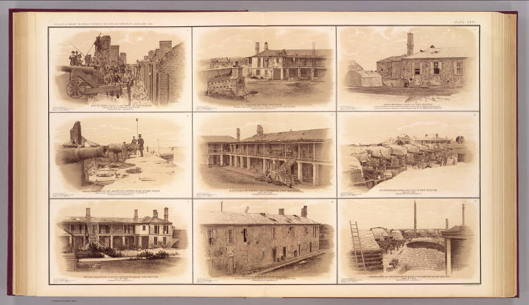
Nine sepia-toned lithographs.
State/Province:
South Carolina
City:
Fort Moultrie (S.C.)
City:
Fort Sumter (Charleston, S.C.)
Event:
U.S. Civil War
Subject:
Military
Full Title:
View of terre-plein of the gorge of Fort Sumter showing the guns on barbette, April 15th, 1861. Parade of Fort Moultrie showing south-western portion of soldiers barracks &c. April 16th, 1861 ... North-western angle of Fort Moultrie, interior of ramparts, back of western barracks, western side of Citadel, brick traverse for protection of magazine, sandbags covering magazine ... View of terre-pleine and parapet of eastern flank of Fort Sumter, also showing traverse constructed to counteract enfilading fire ... Barracks on north face of parade, Fort Moultrie ... South-western angle and face of Fort Moultrie ... Officers quarters, eastern portion of parade, Fort Moultrie ... Western barracks, Fort Moultrie seen from parapets showing the back of the buildings ... Channel face and south-western angle of the ramparts of Fort Moultrie ... (all) Charleston Harbor, S.C.. Accompanying report of Brig. Gen. G.T. Beauregard, C.S. Army. Julius Bien & Co., Lith., N.Y. (1891-1895)
List No:
1780.121
Page No:
pl. CXXI
Series No:
125
Engraver or Printer:
Julius Bien & Co.
Publication Author:
Cowles, Calvin D.
Publication Author:
Davis, George B.
Publication Author:
Kirkley, JAW.
Publication Author:
Perry, Leslie J.
Publication Author:
United States. War Department
Pub Date:
1895
Pub Title:
Atlas to accompany the official records of the Union and Confederate armies. Published under the direction of the Hons. Redfield Proctor, Stephen B. Elkins and Daniel S. Lamont, secretaries of war, by Maj. George B. Davis, U.S. Army, Mr. Leslie J. Perry, civilian expert, Mr. Joseph W. Kirkley, civilian expert, Board of Publication. Compiled by Capt. Calvin D. Cowles, 23d U.S. Infantry. Washington: Government Printing Office, 1891-1895.
Pub Reference:
LC Civil War maps (2nd ed.), 99; Civil War maps in the National Archives, 8; Phillips, 1353; LeGear. Atlases of the United States, 266.
Pub Note:
See note field above.
Pub List No:
1780.000
Pub Type:
Military Atlas
Pub Maps:
158
Pub Height cm:
47
Pub Width cm:
40
Image No:
1780121
Authors:
Beauregard, G. T.; Confederate States of America. Army
Collection:
Rumsey Collection