COLLECTION NAME:
David Rumsey Historical Map Collection
Record
Author:
United States. War Department
Date:
1895
Short Title:
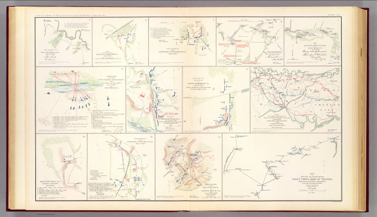
Hanover, Hanover C.H., New Bridge, Mechanicsville, New Market, Malvern Hill, Cross Keys.
Publisher:
U.S. Government Printing Office
Publisher Location:
Washington
Type:
Atlas Map
Obj Height cm:
43
Obj Width cm:
70
Scale 1:
Various
Note:
Thirteen col. maps on 1 sheet. Relief shown by hachures.
State/Province:
Virginia
County:
Hanover County (Va.)
City:
Hanover (Va.)
City:
Old Church (Va.)
Region:
Richmond Region (Va.)
Event:
U.S. Civil War
Subject:
Military
Full Title:
Rough sketch of reconnaissance, May 24th, 1862 (by) R.H. Rush, Col. Lancers. Map illustrating the Battle of Hanover, Va., May 27, 1862. Accompanying report of Brig. Gen. John H. Martindale ... Engagement near Hanover Court-House, Va., May 27, 1862. Accompanying report of Col. S.W. Stryker ... Reconnaissance made on the afternoon of May the 23d, 1862 (by) Alexander Doull ... Map of march from Mount Airey to Old Church, Va., May 23rd 1862 ... accompanying report of Col. R.O. Tyler ... Skirmish between two rebel batteries and Battery B, 1st Md. Arty., June 5th, 1862 at New Bridge, Va. Accompanying report of Captain A. Snow ... Battle of Mechanicsville, Va., June 26 and 27, 1862. Accompanying report of Brig. Gen. T. Seymour ... Sketch of the Battle of New Market, Va., June 30, 1862 ... Map to accompany the report of Brig. Gen. J.E.B. Stuart ... commanding Pamunkey Expedition to the enemy's rear, June 13, 14 and 15, 1862 ... Malvern Hill, Va., Morrell's Division, July 1st, 1862. Engagement near Hanover Court-House, Va., May 27, 1862. Accompanying report of Brig. Gen. D. Butterfield ... Topography of the battle-field of Cross Keys, Va. by Lieut. Col. John Pilsen ... Accompanying report of Maj. Gen. J.C. Fremont ... Map of route and positions, First Corps, Army of Virginia, Major General Sigel, commanding from July 7th to Sept. 10th 1862 (by) Franz Kappner, Maj. and Chf. Engr. Julius Bien & Co., Lith., N.Y. (1891-1895)
List No:
1780.021
Page No:
pl. XXI
Series No:
25
Engraver or Printer:
Butterfield, Daniel
Engraver or Printer:
Doull, Alexander
Engraver or Printer:
Julius Bien & Co.
Engraver or Printer:
Martindale, John H.
Engraver or Printer:
Morrell, George W.
Engraver or Printer:
Pilsen, John
Engraver or Printer:
Rush, Richard H.
Engraver or Printer:
Seymour, Truman
Engraver or Printer:
Snow, Alonzo
Engraver or Printer:
Stryker, Stephen W.
Engraver or Printer:
Stuart, James E. B.
Engraver or Printer:
Tyler, Robert O.
Publication Author:
Cowles, Calvin D.
Publication Author:
Davis, George B.
Publication Author:
Kirkley, JAW.
Publication Author:
Perry, Leslie J.
Publication Author:
United States. War Department
Pub Date:
1895
Pub Title:
Atlas to accompany the official records of the Union and Confederate armies. Published under the direction of the Hons. Redfield Proctor, Stephen B. Elkins and Daniel S. Lamont, secretaries of war, by Maj. George B. Davis, U.S. Army, Mr. Leslie J. Perry, civilian expert, Mr. Joseph W. Kirkley, civilian expert, Board of Publication. Compiled by Capt. Calvin D. Cowles, 23d U.S. Infantry. Washington: Government Printing Office, 1891-1895.
Pub Reference:
LC Civil War maps (2nd ed.), 99; Civil War maps in the National Archives, 8; Phillips, 1353; LeGear. Atlases of the United States, 266.
Pub Note:
See note field above.
Pub List No:
1780.000
Pub Type:
Military Atlas
Pub Maps:
158
Pub Height cm:
47
Pub Width cm:
40
Image No:
1780021
Authors:
United States. War Department
Collection:
Rumsey Collection