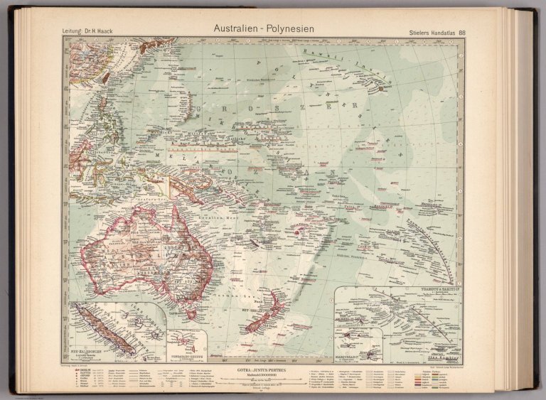
88. Australien - Polynesien. Australia - Polynesia.
short_title
88. Australien - Polynesien. Australia - Polynesia.
Short Title
false
Publisher:
Justus Perthes
publisher
Justus Perthes
Publisher
false
Publisher Location:
Gotha
publisher_location
Gotha
Publisher Location
false
Type:
Atlas Map
type
Atlas Map
Type
false
Obj Height cm:
39
obj_height_cm
39
Obj Height cm
false
Obj Width cm:
42
obj_width_cm
42
Obj Width cm
false
Scale 1:
30,000,000
scale_1
30,000,000
Scale 1
false
Reference:
Espenhorst 2.1.1.1.10
reference
Espenhorst 2.1.1.1.10
Reference
false
World Area:
Pacific
world_area
Pacific
World Area
false
Region:
Oceania
region
Oceania
Region
false
Region:
Oceanica
region
Oceanica
Region
false
Region:
Polynesia
region
Polynesia
Region
false
Full Title:
88. Australien - Polynesien. Australia - Polynesia. (insets) (New Caledonia. Tonga. French Polynesia.)
full_title
88. Australien - Polynesien. Australia - Polynesia. (insets) (New Caledonia. Tonga. French Polynesia.)
Full Title
false
List No:
7839.183
list_no
7839.183
List No
false
Page No:
88
page_no
88
Page No
false
Series No:
183
series_no
183
Series No
false
Engraver or Printer:
Haack
engraver_or_printer
Haack
Engraver or Printer
false
Engraver or Printer:
G. Schmidt
engraver_or_printer
G. Schmidt
Engraver or Printer
false
Engraver or Printer:
Schmidt
engraver_or_printer
Schmidt
Engraver or Printer
false
Engraver or Printer:
Judae
engraver_or_printer
Judae
Engraver or Printer
false
Engraver or Printer:
Reichenbecher
engraver_or_printer
Reichenbecher
Engraver or Printer
false
Publication Author:
Haack, H.
publication_author
Haack, H.
Publication Author
false
Publication Author:
Stieler, Adolf
publication_author
Stieler, Adolf
Publication Author
false
Pub Date:
1925
pub_date
1925
Pub Date
false
Pub Title:
Stieler's Atlas of Modern Geography. 254 Maps & Insets on 108 Sheets Engraved on Copper. Tenth (Centenary) Edition. Completely Revised & Largely Redrawn under the Direction of Professor H. Haack in Justus Perthes' Geogr. Institute. (in two parts). 1925. Gotha: Justus Perthes.
pub_title
Stieler's Atlas of Modern Geography. 254 Maps & Insets on 108 Sheets Engraved on Copper. Tenth (Centenary) Edition. Completely Revised & Largely Redrawn under the Direction of Professor H. Haack in Justus Perthes' Geogr. Institute. (in two parts). 1925. Gotha: Justus Perthes.
Pub Title
false
Pub Note:
Two volume set in English. 10th edition and the Centenary edition. This edition was a very important revision and was issued in German, French, English, Spanish, and Italian. Each map preceded by index map, printed in blue, which is labeled, "Stielers Handatlas, Zehnte Auflage / Hundertjahr-Ausgabe. Gotha: Justus Perthes." Relief shown in hachures. Alphabetical Index of place names not scanned. Over 43 different draftsmen and engravers are listed on the various sheets.
pub_note
Two volume set in English. 10th edition and the Centenary edition. This edition was a very important revision and was issued in German, French, English, Spanish, and Italian. Each map preceded by index map, printed in blue, which is labeled, "Stielers Handatlas, Zehnte Auflage / Hundertjahr-Ausgabe. Gotha: Justus Perthes." Relief shown in hachures. Alphabetical Index of place names not scanned. Over 43 different draftsmen and engravers are listed on the various sheets.
<a href="https://www.extensis.com/support/geoviewer-9" target="_blank">GeoViewer for JP2 and SID files</a>
Download 2
false
Authors:
Haack, H.; Stieler, Adolf
author_thumbnail_label
Haack, H.; Stieler, Adolf
Authors
false
Custom:
AI-Generated Summary:
The map titled "Australien - Polynesien" was authored by H. Haack and Adolf Stieler, published in 1925. It measures 42 cm in width and 39 cm in height and is part of an atlas produced by Justus Perthes. This particular work is a detailed cartographic representation of the Pacific region, specifically highlighting Oceania, including areas such as Australia and Polynesia. It is part of the "Stielers Handatlas," specifically page 88, with the List No 7839.183 and Pub List No 7839.000.
Composition and Medium:
The map is an atlas map, printed with a scale of 1:30,000,000, utilizing color to distinguish various geographical and political features. Relief is depicted using hachures, a technique that uses lines to indicate terrain elevations and slopes, giving a sense of the region's topography.
Style and Features:
The cartographic style is highly detailed and typical of early 20th-century German atlases, known for their precision and clarity. The map includes numerous labels for countries, cities, islands, and oceanic features, providing a comprehensive overview of the region. Insets are present for specific areas such as New Caledonia, Tonga, and French Polynesia, offering more detailed views of these locations.
Subject Matter:
This map covers the vast expanse of the Pacific Ocean, focusing on the landmasses and island groups within Oceania. It highlights Australia prominently, with its states and territories clearly defined. Polynesia and other island groups are meticulously labeled, illustrating the geopolitical landscape of the early 20th century.
Cultural and Historical Context:
In the early 20th century, maps like these were crucial for understanding the geopolitical boundaries and colonial interests in the Pacific region. This map reflects the territorial divisions and naming conventions of the time, which were influenced by European exploration and colonization. The inclusion of detailed insets for specific islands suggests areas of particular interest or strategic importance during this period.
Notable Features:
- Insets: The map contains insets for New Caledonia, Tonga, and French Polynesia, providing more granular detail for these regions. - Inscription and Labels: Numerous place names are inscribed throughout the map, offering insights into the geopolitical and cultural nomenclature of the era. - Scale and Relief: The use of a 1:30,000,000 scale allows for a broad overview of the region, while hachures convey the relief and topography effectively.
Publication and Authorship:
The map is from the 10th edition of "Stielers Handatlas," a significant revision available in multiple languages, underscoring its broad appeal and use. The atlas was a collaborative effort involving over 43 draftsmen and engravers, showcasing the expertise and attention to detail typical of works published by Justus Perthes.
Summary:
This map is a valuable historical document, illustrating the geography, political boundaries, and colonial interests in the Pacific region during the early 20th century. Its detailed cartography and comprehensive labeling make it an important resource for understanding the historical context and geographic knowledge of the time.
Text on Maps:
88. Australien - Polynesien. Australia - Polynesia.