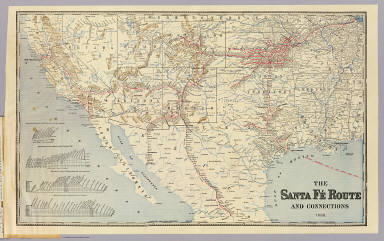
Detail View: David Rumsey Historical Map Collection: Sante Fe Route and connections.
|
Author:
|
Atchison, Topeka, and Santa Fe Railroad Company
|
|
Date:
|
1888
|
|
Short Title:
|
Sante Fe Route and connections.
|
|
Publisher:
|
Rand McNally
|
|
Publisher Location:
|
Chicago
|
|
Type:
|
Timetable Map
|
|
Obj Height cm:
|
39
|
|
Obj Width cm:
|
63
|
|
Scale 1:
|
6,000,000
|
|
Note:
|
Relief shown by hachures. Covers area from Chicago west and south to Veracruz. Profiles: Elevations between San Bernardino and Los Angeles -- Elevations between Barstow and National City -- Elevations between Kansas City and San Francisco -- Elevations between Kansas City and Mexico.
|
|
Reference:
|
LC U.S. railroad maps, 553; Guthorn 553 (map); Guthorn N.A. 34 (illustrated).
|
|
Country:
|
Mexico
|
|
State/Province:
|
U.S. South
|
|
State/Province:
|
U.S. West
|
|
Full Title:
|
Santa Fe Route. Official guide, main lines, branches and connections. Traffic Department, Topeka, Kansas. August, 1888. Rand, McNally & Co., Printers, Chicago.
|
|
List No:
|
3342.001
|
|
Series No:
|
2
|
|
Engraver or Printer:
|
Rand McNally and Company
|
|
Publication Author:
|
Atchison, Topeka, and Santa Fe Railroad Company
|
|
Pub Date:
|
1888
|
|
Pub Title:
|
Santa Fe Route. Official guide, main lines, branches and connections. Traffic Department, Topeka, Kansas. August, 1888. Rand, McNally & Co., Printers, Chicago. (with map) The Santa Fe Route and connections 1888. Rand, McNally & Co., Engravers, Chicago.
|
|
Pub Note:
|
Includes a stamped ticket from Kansas City to Albuquerque. Covers are tan card board 22 x 11 printed with above title against a dark blue and black background.
|
|
Pub List No:
|
3342.000
|
|
Pub Type:
|
Timetable Map
|
|
Pub Maps:
|
1
|
|
Pub Height cm:
|
39
|
|
Pub Width cm:
|
63
|
|
Image No:
|
3342001
|
|
Download 1:
|
|
|
Download 2:
|
|
|
Authors:
|
Atchison, Topeka, and Santa Fe Railroad Company
|
|
Collection:
|
Rumsey Collection
|