COLLECTION NAME:
David Rumsey Historical Map Collection
Record
Author:
Barnard, J.G.
Author:
Bruff, J.
Attributed Author:
Goldsborough
Date:
1851
Short Title:
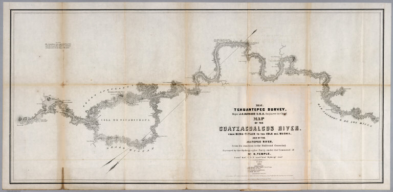
No.5. Map of the Coatzacoalcos River from Mina-titlan to the Isla del Suchil
Publisher:
D. Appleton & Co.
Publisher Location:
New York
Type:
Chart Map
Obj Height cm:
38
Obj Width cm:
80
Scale 1:
120,000
Note:
Uncolored engraved & lithographic map, folded to 24x15. Relief shown by hachures. Depth shown by soundings. Notes: " The soundings are expressed in feet ..." Includes list of Assistants.
Country:
Mexico
Region:
Tehuantepec, Isthmus of (Mexico)
Subject:
Nautical Charts
Full Title:
1851 Tehuantepec Survey, Major J.G. Barnard. U.S.Engineers, Engineer in Chief. Map of the Coatzacoalcos River from Mina-titlan to the Isla del Suchil and of the Jaltepec River from its junction to the railroad crossing. Surveyed by the Hydrographic party under the command of Wm. G. Temple. Passd. Midn. U.S.N. and Chief Hydroge. Asst. Drawn by Louis R.O. Townsend. Lith. of Sarony & Major 117, Fulton St. New York. Entered ... 1852 by B. Fallon ... in the court of Sn. Desct. of New York. (to accompany) Maps Illustrating The Isthmus of Tehuantepec.
List No:
2735.008
Page No:
(5)
Series No:
8
Engraver or Printer:
Endicott & Co.
Engraver or Printer:
Bruff.
Engraver or Printer:
Sarony & Major.
Engraver or Printer:
Smith, Chas. C.
Engraver or Printer:
Williams, J.J.
Engraver or Printer:
Avery, J.C.
Engraver or Printer:
Sherman & Smith.
Engraver or Printer:
Murphy, J.Mc.L.
Engraver or Printer:
Temple, Wm. G.
Engraver or Printer:
Trastour, P.E.
Engraver or Printer:
Schedler, J.
Attributed Publication Author:
Goldsborough
Publication Author:
Barnard, J.G.
Publication Author:
Bruff, J.
Pub Date:
1852
Pub Title:
Maps Illustrating The Isthmus of Tehuantepec. New York: D. Appleton & Company, 200 Broadway. M DCCC LII (1852). (on verso) Entered ... 1852, by B. Fallon ... Louisiana.
Pub Note:
Tooley: Maps were drawn by Bruff; Lacks report vol. Although Bruff is only credited on the second map, he may have had a hand in drawing all or most of them, as he was present for the entire survey. 8 engraved & lithographic maps on 8 sheets; 102 x 98 cm. or smaller, folded in cover 24 x 15 cm. All maps enclosed in brown cloth covered boards with the title on the cover.
Pub List No:
2735.000
Pub Type:
Separate Map
Pub Maps:
8
Pub Height cm:
24
Pub Width cm:
15
Image No:
2735008
Authors:
Barnard, J.G.; Bruff, J.; Goldsborough
