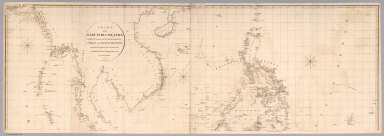
Detail View: David Rumsey Historical Map Collection: Top sheet: Chart of the East India Islands
|
Author:
|
Arrowsmith, Aaron
|
|
Date:
|
1812
|
|
Short Title:
|
Top sheet: Chart of the East India Islands
|
|
Publisher:
|
A. Arrowsmith
|
|
Publisher Location:
|
London
|
|
Type:
|
Chart Map
|
|
Obj Height cm:
|
65
|
|
Obj Width cm:
|
188
|
|
Scale 1:
|
3,000,000
|
|
Note:
|
In two large sheets. Map of Southeast Asia showing the coasts of Burma, Thailand, Malaysia, Indonesia, Vietnam, Philippines and West Papua. Depth shown by bathymetric soundings. Prime meridian: Greenwich.
|
|
Country:
|
Indonesia
|
|
Country:
|
Philippines
|
|
Country:
|
Thailand
|
|
Country:
|
Vietnam
|
|
Region:
|
Southeast Asia
|
|
Full Title:
|
(Top sheet of) Chart of the East India Islands, Exhibiting the several Passages between the Indian and Pacific Oceans; Inscribed to the Commanders and Officers of the British Ships Navigating those Seas, by A. Arrowsmith. Additions to 1812. engraved by S.I. Neele, 352 Strand.
|
|
List No:
|
6711.001
|
|
Series No:
|
1
|
|
Engraver or Printer:
|
Neele, S.J.
|
|
Publication Author:
|
Arrowsmith, Aaron
|
|
Pub Date:
|
1812
|
|
Pub Title:
|
Chart of the East India Islands, Exhibiting the several Passages between the Indian and Pacific Oceans; Inscribed to the Commanders and Officers of the British Ships Navigating those Seas, by A. Arrowsmith. Additions to 1812. engraved by S.I. Neele, 352 Strand.
|
|
Pub List No:
|
6711.000
|
|
Pub Type:
|
Chart Map
|
|
Pub Height cm:
|
131
|
|
Pub Width cm:
|
188
|
|
Image No:
|
6711001
|
|
Download 1:
|
|
|
Download 2:
|
|
|
Authors:
|
Arrowsmith, Aaron
|