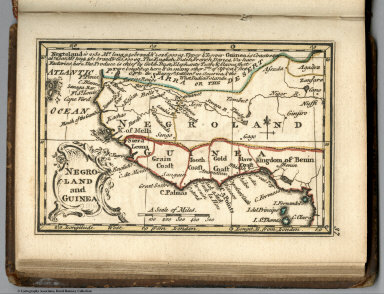
Detail View: David Rumsey Historical Map Collection: Negro Land In Guinea
|
Author:
|
Bowen, Emanuel
|
|
Author:
|
Gibson, John
|
|
Date:
|
1758
|
|
Short Title:
|
Negro Land In Guinea
|
|
Publisher:
|
J. Newberry
|
|
Publisher Location:
|
London
|
|
Type:
|
Atlas Map
|
|
Obj Height cm:
|
7
|
|
Obj Width cm:
|
10
|
|
Scale 1:
|
35,000,000
|
|
Note:
|
First edition. The "Historical Extracts" are short bits of text printed on the maps giving relevant geographical information. A revised edition was published in London in 1792. In 1759, another edition was published adding separate geographical descriptions and correcting some of the maps (see our copy). The Philadelphia 1798 edition by Mathew Carey incorporates the 1759 edition text word for word (excepting the maps of United States which Carey omits in favor of his pocket atlas of the U.S.). Gibson and Bowen made the four sheet map of North America (Stevens 49), and Gibson made the four sheet map of America (Stevens 3).
|
|
Reference:
|
P621.
|
|
Country:
|
Guinea
|
|
Region:
|
West Africa
|
|
Full Title:
|
Negro-Land In Guinea. (to accompany) Atlas Minimus or a New Set of Pocket Maps of the Several Empires, Kingdoms and States of the Known World, with Historical Extracts relative to each. Drawn and Engraved by J. Gibson from the Best Authorities, Revis'd, Corrected and Improv'd by Eman: Bowen Geographer to His Majesty.
|
|
List No:
|
0300.041
|
|
Page No:
|
37
|
|
Series No:
|
41
|
|
Publication Author:
|
Bowen, Emanuel
|
|
Publication Author:
|
Gibson, John
|
|
Pub Date:
|
1758
|
|
Pub Title:
|
Atlas Minimus or a New Set of Pocket Maps of the Several Empires, Kingdoms and States of the Known World, with Historical Extracts relative to each. Drawn and Engraved by J. Gibson from the Best Authorities, Revis'd, Corrected and Improv'd by Eman: Bowen Geographer to His Majesty.
|
|
Pub Reference:
|
P621.
|
|
Pub Note:
|
See note field above.
|
|
Pub List No:
|
0300.000
|
|
Pub Type:
|
World Atlas
|
|
Pub Maps:
|
52
|
|
Pub Height cm:
|
12
|
|
Pub Width cm:
|
9
|
|
Image No:
|
0300041
|
|
Download 1:
|
|
|
Download 2:
|
|
|
Authors:
|
Gibson, John; Bowen, Emanuel
|