COLLECTION NAME:
David Rumsey Historical Map Collection
Record
Author:
Warren, Gouverneur Kemble, 1830-1882
Date:
1861
Short Title:
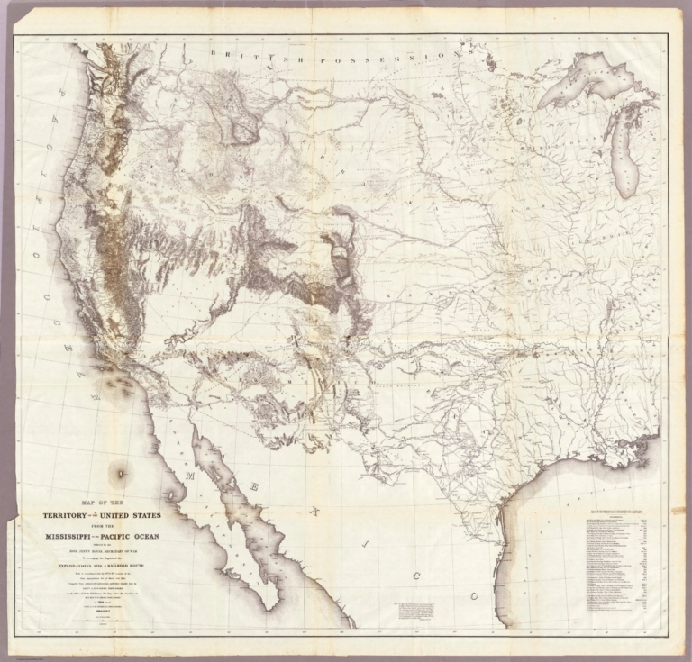
Map Of The Territory Of The United States From The Mississippi To The Pacific.
Publisher:
A.O.P. Nicholson I-XI
Publisher Location:
Washington
Publisher:
T. Ford XII.
Type:
Book Map
Obj Height cm:
106
Obj Width cm:
116
Scale 1:
3,000,000
Note:
The general map published with the Pacific Railroad Survey Reports. This map had earlier issues and later issues. A preliminary listed of those would be: 1855 (our #2289); 1857 (WH and AH's copies)- blank areas in eastern Oregon, fewer authorities; 1857 published with the reports; 1858 early (see Schubert);1858 late (our #2750); 1867 (our #2594). We suspect there are other states and issues, particularly in the period of 1859 to 1866. This is one of the most important maps of the West in the 1850's and 1860's and a study of its different states shows the rapid growth of topographical information from government exploration and mapping. Without color.
Country:
United States
Subject:
U.S. War Dept.
Full Title:
Map Of The Territory Of The United States From The Mississippi To The Pacific Ocean Ordered by the Hon. Jeff'n Davis, Secretary Of War To accompany the Reports of the Explorations For A Railroad Route ... Compiled from authorized explorations and other reliable data by Lieut. G.K. Warren, Topl. Engrs. In the Office of Pacific R.R. Surveys, War Dep. under the direction of Bvt. Maj. W.H. Emory, Topl Engrs. in 1854 and of Capt. A.A. Humphreys, Topl. Engrs. 1854-5-6-7. Engr. by Selmar Siebert.
List No:
0693.018
Series No:
26
Engraver or Printer:
Emory, W.H.
Engraver or Printer:
Humphreys, A.A.
Engraver or Printer:
Siebert, Selmar
Publication Author:
Pacific Railroad Survey
Publication Author:
Warren, Gouverneur Kemble, 1830-1882
Pub Date:
1861
Pub Title:
Reports of Explorations and Surveys, to Ascertain the Most Practicable and Economical Route for a Railroad From the Mississippi River to the Pacific Ocean. Made Under the Direction of the Secretary of War, In 1853-56, According to Acts of Congress of March 3, 1853, May 31, 1854, and August 5, 1854. Volume XI. Washington: George W. Bowman, Printer. 1861. 36th Congress, 2d Session, Senate, Ex. Doc.
Pub Reference:
WC 262.
Pub Note:
This Quarto issue of the report is the House issue, except for volume XI which is the Senate issue. W. Heckrotte has an unusual copy of the Warren U.S. map found in this report. It is dissected on linen and is an earlier version of the map published with the Quarto report. It has 40 authorities vs. 42 in the quarto issue map, shorter note to left of authorities, lots of plate differences, especially: nothing in Owyhee area, differences in N.M., Calif., etc. Looks like someone asked for the map before it was finished -see the Lack of ocean lines in the top half south of Gray's Harbor. In 13 volumes. Bound in full leather with "Explorations and Surveys for a Railroad to the Pacific Ocean" and the volume number on the spine in gold.
Pub List No:
0693.000
Pub Type:
Exploration Book
Pub Maps:
24
Pub Height cm:
31
Pub Width cm:
25
Image No:
0693018.jp2
Authors:
Warren, Gouverneur Kemble, 1830-1882
Collection:
Rumsey Collection